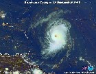
http://www.ssd.noaa.gov/PS/TROP/DATA/RT ... IR4/20.jpg
Also looks like he might have moved just a tad to the SW in this image.
IS NICHOLAS TRYING TO BAND?!.......
Moderator: S2k Moderators
Forum rules

The posts in this forum are NOT official forecasts and should not be used as such. They are just the opinion of the poster and may or may not be backed by sound meteorological data. They are NOT endorsed by any professional institution or STORM2K. For official information, please refer to products from the National Hurricane Center and National Weather Service.
-
dixiebreeze

- S2K Supporter

- Posts: 5140
- Joined: Wed Sep 03, 2003 5:07 pm
- Location: crystal river, fla.
-
Weathermaster
- Tropical Depression

- Posts: 79
- Joined: Thu Sep 04, 2003 10:33 am
- Location: Carolina, PR
Yes, a wobble to the south, but moving more west.
If you see the Water Vapor loops, it appear that there is a channel where the shear has relax. This Channel is between the Leewards and the storm, the shears go south after the westerlies passes PR and the Cold Front is still in higher latitudes.
So, I think that the route of less resistance and hostility for the storm is the west, and Nick may continue to the west for a while and possible a litlle stronger.
:?
So, I think that the route of less resistance and hostility for the storm is the west, and Nick may continue to the west for a while and possible a litlle stronger.
:?
0 likes
-
dixiebreeze
- S2K Supporter
- Posts: 5140
- Joined: Wed Sep 03, 2003 5:07 pm
- Location: crystal river, fla.
-
wxman57

- Moderator-Pro Met

- Posts: 23131
- Age: 68
- Joined: Sat Jun 21, 2003 8:06 pm
- Location: Houston, TX (southwest)
Banding?
I wouldn't exactly say Nick is "banding". Nor would I say Nick is getting better organized. For weak systems like this, you need to look at visible imagery. The circulation center is becoming more broad today. Convection is firing in only one locatin east of the center. I doubt that Nick has TS-force winds any longer. Certainly no TS-force winds near the center.
<img src="http://home.houston.rr.com/wx/nick.gif">
<img src="http://home.houston.rr.com/wx/nick.gif">
0 likes
Who is online
Users browsing this forum: Hurricanehink, Ulf and 45 guests