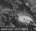
midget cyclone over Thyrrenian Sea

This is the general tropical discussion area. Anyone can take their shot at predicting a storms path.

Moderator: S2k Moderators

Forum rules

The posts in this forum are NOT official forecasts and should not be used as such. They are just the opinion of the poster and may or may not be backed by sound meteorological data. They are NOT endorsed by any professional institution or STORM2K. For official information, please refer to products from the National Hurricane Center and National Weather Service.

Help Support Storm2K
Message
Author
User avatar
DanieleItalyRm
Category 1
Category 1
Posts: 487
Age: 39
Joined: Mon Sep 22, 2008 7:52 am
Location: Rome - Italy - Mediterranean sea

midget cyclone over Thyrrenian Sea

#1 Postby DanieleItalyRm » Wed Jan 18, 2017 6:04 am

Warm core cyclone over THYrrenian sea (FINJAS [met.fu-berlin]) show a tropical characteristics, outflow, spiral band, convection in the center:
998 hpa
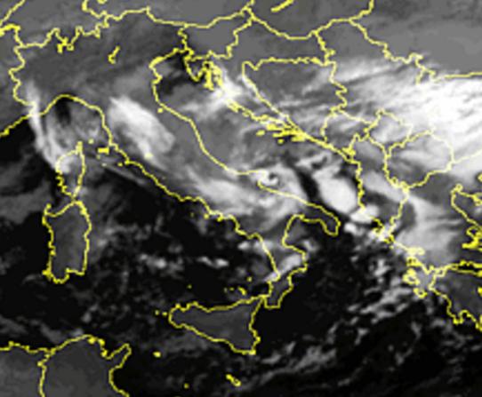
I Think this is a subtropical depression; convection top -40°C and only 15-16°C sea surface.

SAT: http://en.sat24.com/HD/en/it/visual
CAM: (60 km from midget cyclonic center) http://www.vedetta.org/index.php/only-w ... i-san-vito

Image

Image

yesterday 17/01/17 (about 190 km in diameter; 50/70 km extende the max winds from the center)
Image

today 18/01/17 (about 90 km in diameter)

Image
Last edited by DanieleItalyRm on Thu Jan 19, 2017 6:32 am, edited 6 times in total.
0 likes   

User avatar
DanieleItalyRm
Category 1
Category 1
Posts: 487
Age: 39
Joined: Mon Sep 22, 2008 7:52 am
Location: Rome - Italy - Mediterranean sea

Re: midget cyclone over Thyrrenian Sea

#2 Postby DanieleItalyRm » Wed Jan 18, 2017 10:09 am

the system weakening in the next hours (about 90 km in diameter; 30/40 km extende the max winds from the center):
Image

The desert and the cyclone..

Image
Last edited by DanieleItalyRm on Thu Jan 19, 2017 6:31 am, edited 4 times in total.
0 likes   

User avatar
DanieleItalyRm
Category 1
Category 1
Posts: 487
Age: 39
Joined: Mon Sep 22, 2008 7:52 am
Location: Rome - Italy - Mediterranean sea

Re: midget cyclone over Thyrrenian Sea

#3 Postby DanieleItalyRm » Wed Jan 18, 2017 12:59 pm

evening 19:00, extremly midget-central convection, and bands (35 km in diameter; 10/15 km extende the max winds from the center)

Image

Image
Last edited by DanieleItalyRm on Thu Jan 19, 2017 6:32 am, edited 1 time in total.
0 likes   

User avatar
chaser1
S2K Supporter
S2K Supporter
Posts: 5464
Age: 64
Joined: Sat Oct 15, 2005 5:59 pm
Location: Longwood, Fl

Re: midget cyclone over Thyrrenian Sea

#4 Postby chaser1 » Thu Jan 19, 2017 3:31 am

Any analysis suggesting what max. winds might have been at the surface? These spin up's fascinate me, given both their very short lives but often rapid organization.
0 likes   
Andy D

(For official information, please refer to the NHC and NWS products.)

User avatar
DanieleItalyRm
Category 1
Category 1
Posts: 487
Age: 39
Joined: Mon Sep 22, 2008 7:52 am
Location: Rome - Italy - Mediterranean sea

Re: midget cyclone over Thyrrenian Sea

#5 Postby DanieleItalyRm » Thu Jan 19, 2017 5:55 am

chaser1 wrote:Any analysis suggesting what max winds might have been at the surface? .

only 25/30 kt max wind; However,
none has passed through the extremly small center for real datas.
0 likes   

User avatar
chaser1
S2K Supporter
S2K Supporter
Posts: 5464
Age: 64
Joined: Sat Oct 15, 2005 5:59 pm
Location: Longwood, Fl

Re: midget cyclone over Thyrrenian Sea

#6 Postby chaser1 » Thu Jan 19, 2017 3:12 pm

Wild.... certainly would've assumed something appearing as well defined on Satellite would've translated to higher surface winds? I wonder if that end result is essentially that common or if its development (and demise) were so quick that stronger winds simply stayed aloft or just above the surface??
0 likes   
Andy D

(For official information, please refer to the NHC and NWS products.)

Digital-TC-Chaser

Re: midget cyclone over Thyrrenian Sea

#7 Postby Digital-TC-Chaser » Sat Jan 21, 2017 1:26 am

0 likes   

User avatar
chaser1
S2K Supporter
S2K Supporter
Posts: 5464
Age: 64
Joined: Sat Oct 15, 2005 5:59 pm
Location: Longwood, Fl

Re: midget cyclone over Thyrrenian Sea

#8 Postby chaser1 » Sat Jan 21, 2017 2:08 am

Digital-TC-Chaser wrote:http://www.sat.dundee.ac.uk/gallery/gallery_image.php?id=2128&size=s


"dead link"; takes one to a UK Satellite site requiring an account ID and password
0 likes   
Andy D

(For official information, please refer to the NHC and NWS products.)

Digital-TC-Chaser

Re: midget cyclone over Thyrrenian Sea

#9 Postby Digital-TC-Chaser » Sat Jan 21, 2017 2:27 am

chaser1 wrote:
Digital-TC-Chaser wrote:http://www.sat.dundee.ac.uk/gallery/gallery_image.php?id=2128&size=s


"dead link"; takes one to a UK Satellite site requiring an account ID and password


Sorry did not think a sign up was needed.

Image
Image
0 likes   

User avatar
chaser1
S2K Supporter
S2K Supporter
Posts: 5464
Age: 64
Joined: Sat Oct 15, 2005 5:59 pm
Location: Longwood, Fl

Re: midget cyclone over Thyrrenian Sea

#10 Postby chaser1 » Sat Jan 21, 2017 11:12 pm

Awesome and fascinating up close shot there!
0 likes   
Andy D

(For official information, please refer to the NHC and NWS products.)

User avatar
DanieleItalyRm
Category 1
Category 1
Posts: 487
Age: 39
Joined: Mon Sep 22, 2008 7:52 am
Location: Rome - Italy - Mediterranean sea

Re: midget cyclone over Thyrrenian Sea

#11 Postby DanieleItalyRm » Wed Jan 25, 2017 5:37 am

chaser1 wrote:Wild.... certainly would've assumed something appearing as well defined on Satellite would've translated to higher surface winds? I wonder if that end result is essentially that common or if its development (and demise) were so quick that stronger winds simply stayed aloft or just above the surface??


Image

Image
Last edited by DanieleItalyRm on Wed Jan 25, 2017 11:25 am, edited 1 time in total.
0 likes   

User avatar
DanieleItalyRm
Category 1
Category 1
Posts: 487
Age: 39
Joined: Mon Sep 22, 2008 7:52 am
Location: Rome - Italy - Mediterranean sea

Re: midget cyclone over Thyrrenian Sea

#12 Postby DanieleItalyRm » Wed Jan 25, 2017 6:27 am

19 January 2017: Another interesting 35 kt cyclone developed the next day, 19 January, over Adriatic Sea and landfall over Gargano (Apulia)
Also in this case the model show a warm core; Unfortunately, high-resolution Ir images are not available in the most 'interesting hours (05:00 / 05:30);
The convection around the center was more strong than 18 January system.
It rapidly weakened at landfall during the morning.

Image

Image

Image Image
0 likes   

User avatar
chaser1
S2K Supporter
S2K Supporter
Posts: 5464
Age: 64
Joined: Sat Oct 15, 2005 5:59 pm
Location: Longwood, Fl

Re: midget cyclone over Thyrrenian Sea

#13 Postby chaser1 » Thu Jan 26, 2017 3:46 am

They certainly have a fairly decent size wind field with them. Nearly like rapid little tropical depressions that form, then dissipate. I"m curious, in terms of "lifespan".... how long do these mesoscale-like systems tend to last?
0 likes   
Andy D

(For official information, please refer to the NHC and NWS products.)

User avatar
DanieleItalyRm
Category 1
Category 1
Posts: 487
Age: 39
Joined: Mon Sep 22, 2008 7:52 am
Location: Rome - Italy - Mediterranean sea

Re: midget cyclone over Thyrrenian Sea

#14 Postby DanieleItalyRm » Mon Feb 13, 2017 11:57 am

chaser1 wrote:They certainly have a fairly decent size wind field with them. Nearly like rapid little tropical depressions that form, then dissipate. I"m curious, in terms of "lifespan".... how long do these mesoscale-like systems tend to last?


This depends on Shear and other factors. Sometimes they last a 6-10h. but in other cases also 2/4 day. ...
Sometimes these have a very rapid tropical development, more 'rapidly than a normal tropical cyclone. Their ideal condition are often restricted in an old cut off. Perhaps that's why they are also small (like Vince 2005 or Grace 2009) and burn quickly the necessary fuel.

(However, in this 17-18 january case it was a subtropical development).
0 likes   

User avatar
chaser1
S2K Supporter
S2K Supporter
Posts: 5464
Age: 64
Joined: Sat Oct 15, 2005 5:59 pm
Location: Longwood, Fl

Re: midget cyclone over Thyrrenian Sea

#15 Postby chaser1 » Thu Feb 23, 2017 3:58 pm

Hmmmm?? Interesting stuff! Thanks Danielle :D
Basically, "looks" nearly tropical but "acts" baroclinic. Of course, we've seen a few occasions where cold lows over time found a way to transition into respectable tropical cyclones. That process certainly takes a bit of time and of course is occurring over relatively warm water. What is the warmest that those SST's get up there, in the area of the Thyrrenian Sea when these odd spin-up lows try and develop?
0 likes   
Andy D

(For official information, please refer to the NHC and NWS products.)

Alyono
Professional-Met
Professional-Met
Posts: 6961
Joined: Fri Apr 26, 2013 3:52 pm
Location: Texas Coast

Re: midget cyclone over Thyrrenian Sea

#16 Postby Alyono » Thu Feb 23, 2017 7:00 pm

chaser1 wrote:Hmmmm?? Interesting stuff! Thanks Danielle :D
Basically, "looks" nearly tropical but "acts" baroclinic. Of course, we've seen a few occasions where cold lows over time found a way to transition into respectable tropical cyclones. That process certainly takes a bit of time and of course is occurring over relatively warm water. What is the warmest that those SST's get up there, in the area of the Thyrrenian Sea when these odd spin-up lows try and develop?


SSTs are not what is important. It is the difference between the SST and tropopause temperatures that dictates whether or not tropical development occurs. An unusually cold tropopause results in development
1 likes   


Return to “Talkin' Tropics”

Who is online

Users browsing this forum: AnnularCane, floridasun, Hurricane2022, Ivanhater, Kingarabian, TheBurn and 48 guests