Upper Low Over FL Straits: 0% / 0%
Moderator: S2k Moderators
Forum rules

The posts in this forum are NOT official forecasts and should not be used as such. They are just the opinion of the poster and may or may not be backed by sound meteorological data. They are NOT endorsed by any professional institution or STORM2K. For official information, please refer to products from the National Hurricane Center and National Weather Service.
-
StormTracker

- S2K Supporter

- Posts: 2909
- Age: 59
- Joined: Thu Jun 29, 2006 6:06 am
- Location: Quail Heights(Redlands), FL.
Re: Upper Low Over FL Straits: 10% / 10%
Been watching this thing since this am thinking it might be a sleeper(no model support)! This time of year, you never know...ST
0 likes
Something's wrong when you regret, things that haven't happened yet!
-
Hurricaneman

- Category 5

- Posts: 7404
- Age: 45
- Joined: Tue Aug 31, 2004 3:24 pm
- Location: central florida
Re: Upper Low Over FL Straits: 10% / 10%
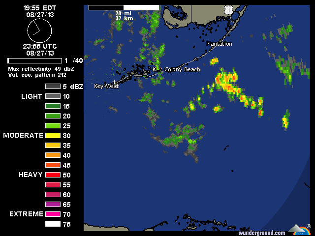
This looks interesting as of now, even T'storms around the possible center according to radar
http://www.atmos.albany.edu/student/ppa ... r_keys.gif
The posts in this forum are NOT official forecast and should not be used as such. They are just the opinion of the poster and may or may not be backed by sound meteorological data. They are NOT endorsed by any professional institution or storm2k.org. For official information, please refer to the NHC and NWS products
0 likes

-
Hurricaneman
- Category 5
- Posts: 7404
- Age: 45
- Joined: Tue Aug 31, 2004 3:24 pm
- Location: central florida
Re: Upper Low Over FL Straits: 10% / 10%
I wouldn't be surprised if this beat pouch25 to invest 96L status
The posts in this forum are NOT official forecast and should not be used as such. They are just the opinion of the poster and may or may not be backed by sound meteorological data. They are NOT endorsed by any professional institution or storm2k.org. For official information, please refer to the NHC and NWS products
The posts in this forum are NOT official forecast and should not be used as such. They are just the opinion of the poster and may or may not be backed by sound meteorological data. They are NOT endorsed by any professional institution or storm2k.org. For official information, please refer to the NHC and NWS products
0 likes

-
Aric Dunn
- Category 5
- Posts: 21238
- Age: 43
- Joined: Sun Sep 19, 2004 9:58 pm
- Location: Ready for the Chase.
- Contact:
Re:
MGC wrote:Just looking at the Key West radar you would go WOW....with time the ULL could bore down to the surface. Something to watch for sure....MGC
its not a "boring" down ... more a convective process of lowering pressure at the surface. the density of the upper atmosphere is not enough to "work" to the surface in that sense.... however it can aid convection that eventually ( do to dynamical processes) develop a surface circ that eventually if either the upper low propagates far enough away or weakens allows the surface circ to deepen... all that said.. the radar out of key west is looking not far above the surface there appears to be at least some development of a lower level circ. it however has a long way to go.
0 likes
Note: If I make a post that is brief. Please refer back to previous posts for the analysis or reasoning. I do not re-write/qoute what my initial post said each time.
If there is nothing before... then just ask
Space & Atmospheric Physicist, Embry-Riddle Aeronautical University,
I believe the sky is falling...
If there is nothing before... then just ask
Space & Atmospheric Physicist, Embry-Riddle Aeronautical University,
I believe the sky is falling...
-
northjaxpro

- S2K Supporter
- Posts: 8900
- Joined: Mon Sep 27, 2010 11:21 am
- Location: Jacksonville, FL
Yeah, Aric it has way to go still. However, Key West radar clearly shows a mid level circulation moving through the Middle Keys currently. Pressure at Marathon at this hour was at 1015.8 mb, not very low but pressures there earlier on Tuesday was at 1017 mb, so slight drop.
We will see what happens on Wednesday. The system will enter the SE GOM and if it can buid convection, it will definitely help the process of getting this at the surface as time progresses. A system to watch for sure.
We will see what happens on Wednesday. The system will enter the SE GOM and if it can buid convection, it will definitely help the process of getting this at the surface as time progresses. A system to watch for sure.
Last edited by northjaxpro on Wed Aug 28, 2013 12:32 am, edited 1 time in total.
0 likes
NEVER, EVER SAY NEVER in the tropics and weather in general, and most importantly, with life itself!!
________________________________________________________________________________________
Fay 2008 Beryl 2012 Debby 2012 Colin 2016 Hermine 2016 Julia 2016 Matthew 2016 Irma 2017 Dorian 2019
________________________________________________________________________________________
Fay 2008 Beryl 2012 Debby 2012 Colin 2016 Hermine 2016 Julia 2016 Matthew 2016 Irma 2017 Dorian 2019
-
jaguarjace

- Category 4

- Posts: 975
- Age: 31
- Joined: Sat Jun 11, 2011 7:38 am
- Location: Khon Kaen, Thailand
Re: Upper Low Over FL Straits: 10% / 10%
Made a gif loop.

0 likes
Owner of the Tropical Archive YouTube channel
Web Developer at Force Thirteen
Twitter/X : @force13_support
Web Developer at Force Thirteen
Twitter/X : @force13_support

Re: Upper Low Over FL Straits: 10% / 10%
Still 10% at 2am per NHC but sure does look interesting after this slow summer..grin! Either way gonna be a poor day in the Keys for suntans. KMTH dropped from 30.02 to 29.95 over past 6 hours...Marathon...which is midway down the Keys. KEYW=Key West went from 30.02 to 29.96 at the far end of the Keys. Up on the mainland KMIA, Miami International, did a 30.03 to a 29.96
0 likes
-
Hurricane Alexis

- Category 2

- Posts: 683
- Age: 29
- Joined: Thu Jun 14, 2012 7:59 pm
- Location: Miami,Florida
Feeder band setting up over SE Florida. Kinda weird cause only tropical cyclone's bring feeder bands like this over here.
0 likes
Personal Forecast Disclaimer:
The posts in this forum are NOT official forecast and should not be used as such. They are just the opinion of the poster and may or may not be backed by sound meteorological data. They are NOT endorsed by any professional institution or storm2k.org. For official information, please refer to the NHC and NWS products.
The posts in this forum are NOT official forecast and should not be used as such. They are just the opinion of the poster and may or may not be backed by sound meteorological data. They are NOT endorsed by any professional institution or storm2k.org. For official information, please refer to the NHC and NWS products.
-
cycloneye

- Admin

- Posts: 148728
- Age: 69
- Joined: Thu Oct 10, 2002 10:54 am
- Location: San Juan, Puerto Rico
Re: Upper Low Over FL Straits: 0% / 0%
Down to 0%-0%.
CLOUDINESS AND THUNDERSTORMS OVER SOUTH FLORIDA AND ADJACENT WATERS
ARE ASSOCIATED WITH A LOW PRESSURE SYSTEM IN THE MIDDLE TO UPPER
LEVELS OF THE ATMOSPHERE. THERE ARE NO SIGNS OF A SURFACE
CIRCULATION...AND NO DEVELOPMENT OF THIS DISTURBANCE IS EXPECTED
WHILE IT DRIFTS NORTHWARD DURING THE NEXT FEW DAYS. THIS SYSTEM
HAS A LOW CHANCE...NEAR 0 PERCENT...OF BECOMING A TROPICAL CYCLONE
DURING THE NEXT 48 HOURS...AND A LOW CHANCE...NEAR 0 PERCENT...OF
BECOMING A TROPICAL CYCLONE DURING THE NEXT 5 DAYS.
0 likes
Visit the Caribbean-Central America Weather Thread where you can find at first post web cams,radars
and observations from Caribbean basin members Click Here
and observations from Caribbean basin members Click Here

Re: Upper Low Over FL Straits: 0% / 0%
That about sums up the season so far. lolcycloneye wrote:Down to 0%-0% ...
0 likes
-
vbhoutex

- Storm2k Executive
- Posts: 29139
- Age: 74
- Joined: Wed Oct 09, 2002 11:31 pm
- Location: Cypress, TX
- Contact:
Re: Upper Low Over FL Straits: 0% / 0%
ok, am I crazy? Uh, don't answer that!!! Did this make a right turn overnight? IIRC, it was moving WNW to NW yesterday and now it looks like it is going up the spine of the peninsula.
0 likes
Skywarn, C.E.R.T.
Please click below to donate to STORM2K to help with the expenses of keeping the site going:

Please click below to donate to STORM2K to help with the expenses of keeping the site going:
Re: Upper Low Over FL Straits: 0% / 0%
vbhoutex wrote:ok, am I crazy? Uh, don't answer that!!! Did this make a right turn overnight? IIRC, it was moving WNW to NW yesterday and now it looks like it is going up the spine of the peninsula.
the NAM has it drifting up the spine as well...really hasnt moved all that much for a few days. Steering flow for surface features would suggest a northern drift.....
0 likes

Re: Upper Low Over FL Straits: 0% / 0%
Story of this season most times, watching mid and upper level lows for entertainment because there is nothing else going on in the tropics. 
0 likes
-
northjaxpro
- S2K Supporter
- Posts: 8900
- Joined: Mon Sep 27, 2010 11:21 am
- Location: Jacksonville, FL
The steering flow is weak currently, and the system did resume a more northward drift the past several hours. Look like a wet day in store for the extreme southern peninsula. No development expected, especially now that this Mid-Upper Low appears headed to move up the spine of the peninsula for the time being. Just another rainmaker for the southern peninsula.
0 likes
NEVER, EVER SAY NEVER in the tropics and weather in general, and most importantly, with life itself!!
________________________________________________________________________________________
Fay 2008 Beryl 2012 Debby 2012 Colin 2016 Hermine 2016 Julia 2016 Matthew 2016 Irma 2017 Dorian 2019
________________________________________________________________________________________
Fay 2008 Beryl 2012 Debby 2012 Colin 2016 Hermine 2016 Julia 2016 Matthew 2016 Irma 2017 Dorian 2019

Re: Upper Low Over FL Straits: 0% / 0%
Local met is saying that this is going north and will only be a rainmaker for Florida - rest of Gulf is protected by the high and its dry air.
0 likes
Re: Upper Low Over FL Straits: 0% / 0%
LaBreeze wrote:Local met is saying that this is going north and will only be a rainmaker for Florida - rest of Gulf is protected by the high and its dry air.
there is a naked LLC in the middle of the GOM moving towards TX....
0 likes
Who is online
Users browsing this forum: No registered users and 68 guests