#66 Postby HURAKAN » Sat Apr 03, 2010 10:22 pm
I got this on my e-mail
ATLANTIC (ATL) - North Atlantic Ocean, Caribbean Sea, Gulf of Mexico
Canary Islands LOW
------------------
I do not have a track for this system, but I wanted to include a
few brief comments by way of documenting an interesting eastern
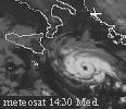
Atlantic low-pressure system in early February. A 1045 UTC visible
image made on the morning of 1 February depicts a LOW to the west-
southwest of the Canary Islands. The system was characterized by
convection which had wrapped around the low-level center, and some of
the models had analyzed the system as symmetric warm core on the
preceding day. According to Sheldon Kusselson of the Satellite
Analysis Branch, precipitable water values near the center were running
about 150 to 175% of normal--very unusual for that location at that
time of year. NHC considered opening an invest on the system, but the
convection soon became sheared so no invest was opened.
After the weakening LOW had become sheared and moved to the north of
the Canary Islands, Julian Heming of the UK Met. Office noted that its
appearance was similar to Hurricane Vince of 2005 after it had become
sheared and weakened. Julian reported on 2 February that on the
previous day he had noted a couple of 35-kt wind barbs in ASCAT data.
On 4 February, as the LOW was approaching the Straits of Gibraltar
area, convection made a comeback and an image at 04/1945 UTC depicts
a sort of "eye-like feature". A weather station at Gibraltar reported
64 mm of rain from 04/0000 to 04/0600 UTC.
According to Jack Beven of NHC, there are no formal plans to add
this system as an unnamed subtropical storm. Jack indicated that there
appeared to be a frontal structure connected with the system when it
looked at its convective best on 1 February.
0 likes