http://hurricane.atmos.colostate.edu/Fo ... ct2008.pdf
They say that the MJO being favored to enhance activity in the first part of the month will be the main cause for the tropical action in this month.
Frank2,what is your take on this October forecast by the Colorado State University team?
Philip J. Klotzbach / Dr Gray October forecast=3/2/1
Moderator: S2k Moderators
Forum rules

The posts in this forum are NOT official forecasts and should not be used as such. They are just the opinion of the poster and may or may not be backed by sound meteorological data. They are NOT endorsed by any professional institution or STORM2K. For official information, please refer to products from the National Hurricane Center and National Weather Service.
-
HURAKAN

- Professional-Met

- Posts: 46086
- Age: 38
- Joined: Thu May 20, 2004 4:34 pm
- Location: Key West, FL
- Contact:
Three named systems in October seems logical. Expect another non-tropical system to evolve into a named system.
Forum rules
The posts in this forum are NOT official forecast and should not be used as such. They are just the opinion of the poster and may or may not be backed by sound meteorological data. They are NOT endorsed by any professional institution or storm2k.org. For official information, please refer to the NHC and NWS products.
0 likes

Re: Philip J. Klotzbach / Dr Gray October forecast=3/2/1
Big reliance on the MJO phase going positive over the next few weeks. Sounds like a set up for a big Mitch type storm in the Caribbean.
They practically say we have had a negative MJO capping of convection for the last weeks but the uncapping and positive phase with good SST's is coming in October.
They practically say we have had a negative MJO capping of convection for the last weeks but the uncapping and positive phase with good SST's is coming in October.
0 likes
-
cycloneye

- Admin

- Posts: 148742
- Age: 69
- Joined: Thu Oct 10, 2002 10:54 am
- Location: San Juan, Puerto Rico
Re: Philip J. Klotzbach / Dr Gray October forecast=3/2/1
Here is why the Colorado team has those October numbers.MJO that will favor Tropical Activity is in the green lines.

0 likes
Re: Philip J. Klotzbach / Dr Gray October forecast=3/2/1
From Wikkipedia:
The Madden-Julian Oscillation (MJO) is an equatorial traveling pattern of anomalous rainfall that is planetary in scale. The mechanism and cause of the MJO is as yet not well-understood and is a subject of ongoing study.
The MJO is characterized by an eastward progression of large regions of both enhanced and suppressed tropical rainfall, observed mainly over the Indian Ocean and Pacific Ocean. The anomalous rainfall is usually first evident over the western Indian Ocean, and remains evident as it propagates over the very warm ocean waters of the western and central tropical Pacific. This pattern of tropical rainfall then generally becomes very nondescript as it moves over the cooler ocean waters of the eastern Pacific but reappears over the tropical Atlantic and Indian Ocean. The wet phase of enhanced convection and precipitation is followed by a dry phase where convection is suppressed. Each cycle lasts approximately 30-60 days.
The MJO is also known as the 30-60 day oscillation, 30-60 day wave, or intraseasonal oscillation.
Atmospheric patterns
There are distinct patterns of lower-level and upper-level atmospheric circulation anomalies which accompany the MJO-related pattern of tropical rainfall. These circulation features extend around the globe and are not confined to only the eastern hemisphere.
There is strong year-to-year (interannual) variability in MJO activity, with long periods of strong activity followed by periods in which the oscillation is weak or absent. This interannual variability of the MJO is partly linked to the El Niño-Southern Oscillation (ENSO) cycle. In the Pacific, strong MJO activity is often observed 6 - 12 months prior to the onset of an El Niño episode, but is virtually absent during an El Niño episode, while MJO activity is typically greater during a La Niña episode. Globally, the interannual variability of the MJO is most determined by atmospheric internal dynamics.
The phase of the MJO is also extremely important for assessing whether conditions are conducive to tropical storm development over the tropical and subtropical North Pacific and North Atlantic ocean basins. For example, MJO-related descending motion over the tropical Atlantic is not favorable for tropical storm development, whereas MJO-related ascending motion over the North Atlantic is quite favorable for tropical storm development. The MJO is monitored routinely by both the USA National Hurricane Center and the USA Climate Prediction Center during the Atlantic hurricane (tropical cyclone) season to aid in anticipating periods of relative activity or inactivity.
0 likes
cycloneye,
It sounds like CSU depending on the MJO (in only the first part of the month, as they stated) is a big "if", if you ask me, since it takes far more than that to make a hurricane, even with above normal SST's and below normal SLP's, since both are almost never "just normal"...
It does seem like they realize that the season might end a bit early or "on time" this year, since they mention this favorable period to only be in the first part of the month...
0 likes
-
Ed Mahmoud
Re: Philip J. Klotzbach / Dr Gray October forecast=3/2/1
JB has been expecting one last pulse in October based on the MJO.
I don't want to say a certain major US state is off the hook, even though it almost certainly is, but Louisiana to Florida, IMHO, need to keep a watch during October, remembering systems like Lili, Opal and Wilma.
A certain major US state now turns its eyes to the Pacific, where landfalling EPac systems can send remnant mid level circulations and moisture, which can sometimes interact with mid-latitude features to produce excessive rainfall.
I think we all remember the remnants of Pacific Hurricane Rosa in 1994, and how the San Jacinto river caught fire near Houston.
0 likes
-
bvigal

- S2K Supporter

- Posts: 2276
- Joined: Sun Jul 24, 2005 8:49 am
- Location: British Virgin Islands
- Contact:
Re: Philip J. Klotzbach / Dr Gray October forecast=3/2/1
Hmm, hadn't seen this, thanks for posting, Luis!
If +MJO is back, will know soon enough. Looks like we will have to wait and see what happens, certainly not out of the woods yet.
If +MJO is back, will know soon enough. Looks like we will have to wait and see what happens, certainly not out of the woods yet.
0 likes
-
El Nino

- Category 1

- Posts: 454
- Age: 48
- Joined: Sun Oct 16, 2005 3:18 pm
- Location: Lima - Miraflores (Peru)
- Contact:
Re: Philip J. Klotzbach / Dr Gray October forecast=3/2/1
3 more storms in october is quite possible. Surely if MJO is back. And one last in november.
What are the statistics over the last 20 years ?
What are the statistics over the last 20 years ?
0 likes
Re: Philip J. Klotzbach / Dr Gray October forecast=3/2/1
Considering we had 2 systems get named last week....3 for the entire month of october doesn't seem unreasonable, esp if the MJO goes positive....we could get a few spin-ups in a pretty small stretch of time. Not saying they will all be landfalling 'canes....but 3 formations in the basin seems plausible.
Here is the climatology view...looks like 2 or so storms after october 1 is the average in the prototype 10 storm season.
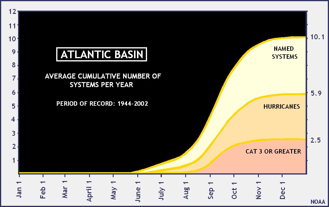
Here is the climatology view...looks like 2 or so storms after october 1 is the average in the prototype 10 storm season.
El Nino wrote:3 more storms in october is quite possible. Surely if MJO is back. And one last in november.
What are the statistics over the last 20 years ?
0 likes
Re: Philip J. Klotzbach / Dr Gray October forecast=3/2/1
3 more storms in october is quite possible. Surely if MJO is back. And one last [one] in november.
With all due respect, let's hope that we don't have to deal with anything else this month or next, since we are the ones up here who have to deal with it, if it comes our way...
0 likes
Re: Philip J. Klotzbach / Dr Gray October forecast=3/2/1
october fish or florida?
Frank2 wrote:3 more storms in october is quite possible. Surely if MJO is back. And one last [one] in november.
With all due respect, let's hope that we don't have to deal with anything else this month or next, since we are the ones up here who have to deal with it, if it comes our way...
0 likes
Who is online
Users browsing this forum: kevin and 52 guests