Bermuda ever been hit?
Moderator: S2k Moderators
Forum rules

The posts in this forum are NOT official forecasts and should not be used as such. They are just the opinion of the poster and may or may not be backed by sound meteorological data. They are NOT endorsed by any professional institution or STORM2K. For official information, please refer to products from the National Hurricane Center and National Weather Service.
-
DESTRUCTION5

- Category 5

- Posts: 4430
- Age: 44
- Joined: Wed Sep 03, 2003 11:25 am
- Location: Stuart, FL
Bermuda ever been hit?
Anyone know if a storm has ever OFFICIALLY made landfall in bermuda as in the Center crossing directly over the Island?
Last edited by DESTRUCTION5 on Fri Sep 08, 2006 10:08 am, edited 1 time in total.
0 likes

-
StormWarning1
- Category 1

- Posts: 254
- Joined: Sun Jul 10, 2005 9:29 pm
- Location: Nashville TN
This one in 1948 did, it was storm number 8 of that year.
http://www.wunderground.com/hurricane/at1948.asp
Fabians eyewall in 2003 also.
http://www.wunderground.com/hurricane/at2003.asp
http://www.wunderground.com/hurricane/at1948.asp
Fabians eyewall in 2003 also.
http://www.wunderground.com/hurricane/at2003.asp
0 likes
-
dwsqos2
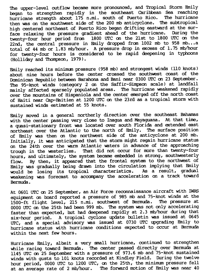
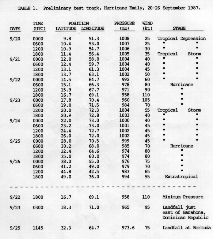
Hurricane Emily (1987) made an official landfall on Bermuda.
Page 2 of Preliminary Report
Page 7 of Preliminary Report (BT)
Page 2 of Preliminary Report
Page 7 of Preliminary Report (BT)
0 likes

I'm sure they have been hit directly several times. Records just don't go back far enough to prove it. Nevertheless, this should shed more light on the issue.
Bermuda is probably the most exposed piece of real estate in the entire Atlantic because of the natural tendency of Cape Verde storms to recurve. It's also probably the safest place to ride out a hurricane because of their incredibly strict building code.
Bermuda is probably the most exposed piece of real estate in the entire Atlantic because of the natural tendency of Cape Verde storms to recurve. It's also probably the safest place to ride out a hurricane because of their incredibly strict building code.
0 likes
-
CrazyC83
- Professional-Met

- Posts: 34310
- Joined: Tue Mar 07, 2006 11:57 pm
- Location: Deep South, for the first time!
abajan wrote:I'm sure they have been hit directly several times. Records just don't go back far enough to prove it. Nevertheless, this should shed more light on the issue.
Bermuda is probably the most exposed piece of real estate in the entire Atlantic because of the natural tendency of Cape Verde storms to recurve. It's also probably the safest place to ride out a hurricane because of their incredibly strict building code.
IIRC, only 4 people died in Fabian there. (The rest died offshore)
0 likes


And three of the four people from Fabian died from drowning because they decided to go out in the middle of the storm, and got swept off a bridge that should have been closed.
IIRC, the NHC was also getting snippy with Bermudan officials because it felt like the building codes there might be giving some people a false sense of security about the approaching storm.
HURRICANE FABIAN DISCUSSION NUMBER 36
NWS TPC/NATIONAL HURRICANE CENTER MIAMI FL
11 AM EDT FRI SEP 05 2003
ALTHOUGH THE EYE IS NOT VISIBLE AT THIS TIME ON SATELLITE
IMAGERY...MICROWAVE DATA STILL SHOWS THE PRESENCE OF A LARGE AND WELL-DEFINED EYE. THIS WAS CONFIRMED BY DATA FROM A RECONNAISSANCE PLANE THAT INDICATED THAT THE EYE WAS LARGE AND ELONGATED. THE MINIMUM PRESSURE HAS RISEN TO 951 BUT FLIGHT LEVEL WINDS WERE 118 KNOTS. THIS DATA SUPPORT AN INITIAL INTENSITY OF 105 KNOTS AT THIS TIME. SOME FLUCTUATIONS IN INTENSITY ARE LIKELY WITHIN THE NEXT 12 TO 24 HOURS BUT A GRADUAL WEAKENING THEN SHOULD BEGIN THEREAFTER...AS THE SHEAR INCREASES ANDTHE HURRICANE ENCOUNTERS COOL WATERS. FABIAN SHOULD BEGIN TO BECOME EXTRATROPICAL BY 48 HOURS.
FABIAN IS MOVING NORTHWARD OR 355 DEGREES AT 15 KNOTS. FABIAN INNER CORE IS EXPECTED TO PASS VERY CLOSE TO BERMUDA THIS AFTERNOON. IN FACT...UNFORTUNATELY...THE PROJECTED TRACK BRINGS THE EAST EYEWALL WITH THE STRONGEST WINDS OVER THE ISLAND. FABIAN IS READY TO RECURVE AND IN ABOUT 12 TO 24 HOURS...IT WILL BE MOVING TOWARD THE NORTHEAST WITH A SIGNIFICANT INCREASE IN FORWARD SPEED.
BERMUDA IS ALREADY EXPERIENCING STRONG WINDS AND THE WEATHER SHOULD GRADUALLY WORSEN. BERMUDA OFFICIALS AND RESIDENTS HAVE IMPLEMENTED THEIR HURRICANE PLANS AND AT THIS TIME...WE CAN ONLY HOPE FOR THE BEST.
FORECASTER AVILA
0 likes
-
NC George

- Category 2

- Posts: 635
- Age: 55
- Joined: Sun Sep 14, 2003 11:44 am
- Location: Washington, NC, USA
I don't think that was being snippy. It is just the truth, what more could they do with winds already approaching hurricane force? It's not like the people could all evacuate the island.
0 likes
Bertha '96, Fran '96, Bonnie '98, Dennis '99, Floyd '99  , Isabel '03, Irene '11, Matthew '16, Isaias '20, PTC16????
Avatar is heading into Florence 2018, moving friend's boat, only land between us and Hurricane Florence is Ocracoke Island!
Avatar is heading into Florence 2018, moving friend's boat, only land between us and Hurricane Florence is Ocracoke Island!
-
StormTracker

- S2K Supporter

- Posts: 2909
- Age: 59
- Joined: Thu Jun 29, 2006 6:06 am
- Location: Quail Heights(Redlands), FL.
-
StormTracker
- S2K Supporter
- Posts: 2909
- Age: 59
- Joined: Thu Jun 29, 2006 6:06 am
- Location: Quail Heights(Redlands), FL.
Who is online
Users browsing this forum: Kingarabian and 80 guests