*new* TS Ernesto - Florida Impact #4 *unnoficial*
Moderator: S2k Moderators
Forum rules

The posts in this forum are NOT official forecasts and should not be used as such. They are just the opinion of the poster and may or may not be backed by sound meteorological data. They are NOT endorsed by any professional institution or STORM2K. For official information, please refer to products from the National Hurricane Center and National Weather Service.
-
johngaltfla

- Category 5

- Posts: 2073
- Joined: Sun Jul 10, 2005 9:17 pm
- Location: Sarasota County, FL
- Contact:
-
johngaltfla
- Category 5
- Posts: 2073
- Joined: Sun Jul 10, 2005 9:17 pm
- Location: Sarasota County, FL
- Contact:
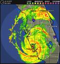
Kevin_Cho wrote:One reason I put 65+ MPH winds lol...the only thing that may change in my opinion is the core winds, the periphery will stay relatively the same w/ TS winds. However, at this time, it looks as if Ernesto is now starting to go more northwesterly, so...my forecast may be scrapped lol...At this rate, it may actually make landfall where the NHC thinks it will...but who knows, it's wait and see at this point.
k e v i n . c h o
naples, fl
The last VDM was WSW of NHC projected point, so I think we may have more time over water than originally thought. Keep up the good work Kevin!
0 likes
-
CentralFlGal

- S2K Supporter

- Posts: 573
- Joined: Mon May 16, 2005 9:32 pm
- Location: Cocoa Beach, FL
Kevin,
Are you and Mike still collaborating on weather update videos? I did a search for his SN here, but nothing came up. Is he no longer here?
I enjoyed watching what you two put together last season - very informative, as is your work above.
Keep up the good work translating information into easy-to-see graphics for us laypersons.
0 likes


-
gatorcane89
- Tropical Wave

- Posts: 2
- Joined: Tue Aug 29, 2006 5:20 am
Whew!... not my problem anymore
Moved to Pittsburgh from Jupiter. It's 75 here and sunny. I was done with the storms. Glad to be a spectator for once and not a participant.
0 likes
Who is online
Users browsing this forum: No registered users and 79 guests