After Florida...then where
Moderator: S2k Moderators
Forum rules

The posts in this forum are NOT official forecasts and should not be used as such. They are just the opinion of the poster and may or may not be backed by sound meteorological data. They are NOT endorsed by any professional institution or STORM2K. For official information, please refer to products from the National Hurricane Center and National Weather Service.
-
tomboudreau

- Category 5

- Posts: 1869
- Age: 48
- Joined: Tue Feb 18, 2003 6:07 pm
- Location: Carnegie, PA
- Contact:
After Florida...then where
Okay...I know its heading towards Florida...where is this system heading? Am I going to need to pay more attention to this system on vacation on the Outer Banks? Just curious. If need be, I can keep the laptop on and downloading the latest information.
0 likes


-
hurricanedude

- Military Member

- Posts: 1856
- Joined: Tue Oct 08, 2002 9:54 am
- Location: Virginia Beach, Virginia
- Contact:
-
Hurricaneman

- Category 5
- Posts: 7404
- Age: 45
- Joined: Tue Aug 31, 2004 3:24 pm
- Location: central florida
-
tomboudreau
- Category 5
- Posts: 1869
- Age: 48
- Joined: Tue Feb 18, 2003 6:07 pm
- Location: Carnegie, PA
- Contact:

-
Hybridstorm_November2001

- S2K Supporter

- Posts: 2817
- Joined: Sat Aug 21, 2004 2:50 pm
- Location: SW New Brunswick, Canada
- Contact:
hurricanedude wrote:Lyons said after crossing florida it could go up to the carolinas and then new england...multiple landfalls are possibe with this
This is just my own thoughts, and we all know tracks can change. However looking at the latest NHC track, and the model runs, it kind of reminds me of old charts I have of Donna in 1960 (both in terms of projected track, and pattern setup). Donna was somewhat different though (longer tracker, and North of the Islands), but we'll see.

0 likes
-
FrontRunner
- Tropical Depression

- Posts: 68
- Age: 42
- Joined: Wed Aug 23, 2006 9:01 pm
- Location: Westchester, NY
Who knows, it could end up having a track similar to this notable hurricane:
http://weather.unisys.com/hurricane/atlantic/1960/DONNA/track.gif
At this point though it looks like Ernesto probably won't be as strong when hitting Florida or during any possible track up the east coast. Just a possible track similarity.
http://weather.unisys.com/hurricane/atlantic/1960/DONNA/track.gif
At this point though it looks like Ernesto probably won't be as strong when hitting Florida or during any possible track up the east coast. Just a possible track similarity.
0 likes
-
brunota2003

- S2K Supporter
- Posts: 9476
- Age: 35
- Joined: Sat Jul 30, 2005 9:56 pm
- Location: Stanton, KY...formerly Havelock, NC
- Contact:
Yea...it will come down to how strong it gets in the Gulf and how badly does the inner core get disrupted when it crosses Florida...assuming it crosses Florida...I have my eyes on it and wont look back until I know I am safe...FrontRunner wrote:Who knows, it could end up having a track similar to this notable hurricane:
http://weather.unisys.com/hurricane/atlantic/1960/DONNA/track.gif
At this point though it looks like Ernesto probably won't be as strong when hitting Florida or during any possible track up the east coast. Just a possible track similarity.
0 likes
-
wxwatcher91

- Category 5
- Posts: 1606
- Joined: Wed Jul 06, 2005 2:43 pm
- Location: Keene, NH
- Contact:

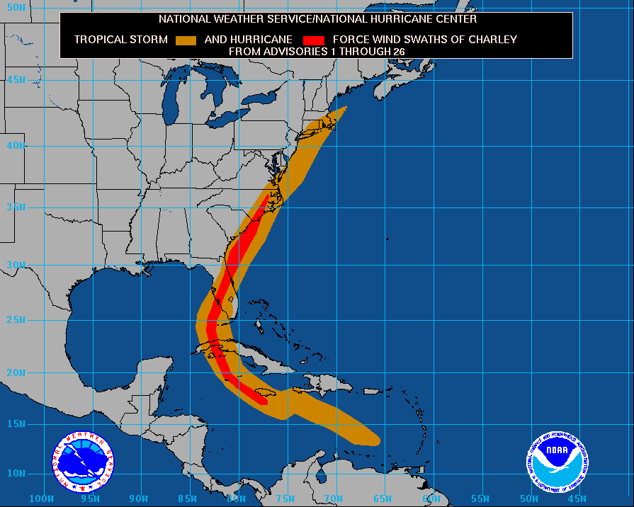

The Charley track posted from wunderground is incorrect in one aspect. The storm was a hurricane during its landfall near Myrtle Beach.
Such a storm would be even worse this year since it has been a VERY wet summer in parts of the eastern Carolinas. The similar was true in 1999 when Floyd caused moderated damage to areas that saw only TS force winds. The wet ground couldn't hold on to all the trees.
What would be even worse would be for Ernesto to hit the area dumping even more rain then have Florence or a later storm come up behind it.
0 likes
-
brunota2003
- S2K Supporter
- Posts: 9476
- Age: 35
- Joined: Sat Jul 30, 2005 9:56 pm
- Location: Stanton, KY...formerly Havelock, NC
- Contact:
That is what happend to us during Floyd...Dennis came and soaked the area, then Floyd came and finished the job...I still remember seeing all the video in the news with pigs ontop of roofs at the farms and all the flooding...very horrible...and yes I did also notice the wunderground track is just a "tad" off since it was still a hurricane well up into Eastern NC according to the NHC windfield map...Regit wrote:The Charley track posted from wunderground is incorrect in one aspect. The storm was a hurricane during its landfall near Myrtle Beach.
Such a storm would be even worse this year since it has been a VERY wet summer in parts of the eastern Carolinas. The similar was true in 1999 when Floyd caused moderated damage to areas that saw only TS force winds. The wet ground couldn't hold on to all the trees.
What would be even worse would be for Ernesto to hit the area dumping even more rain then have Florence or a later storm come up behind it.
0 likes
-
oceancounty
- Tropical Low

- Posts: 33
- Joined: Mon Sep 19, 2005 1:46 pm
- Location: Ocean County, New Jersey
If it was only remnants here at the Jersey shore, then we could use the rain. If it is a strong tropical storm or even a hurricane up here, then we would definately have a problem. I don't even think people up here would know what to do if a hurricane hit us, it would probably be mass chaos at the shore.
0 likes
-
storms in NC

- S2K Supporter
- Posts: 2338
- Joined: Thu Jul 28, 2005 2:58 pm
- Location: Wallace,NC 40 miles NE of Wilm
- Contact:
brunota2003 wrote:That is what happend to us during Floyd...Dennis came and soaked the area, then Floyd came and finished the job...I still remember seeing all the video in the news with pigs ontop of roofs at the farms and all the flooding...very horrible...and yes I did also notice the wunderground track is just a "tad" off since it was still a hurricane well up into Eastern NC according to the NHC windfield map...Regit wrote:The Charley track posted from wunderground is incorrect in one aspect. The storm was a hurricane during its landfall near Myrtle Beach.
Such a storm would be even worse this year since it has been a VERY wet summer in parts of the eastern Carolinas. The similar was true in 1999 when Floyd caused moderated damage to areas that saw only TS force winds. The wet ground couldn't hold on to all the trees.
What would be even worse would be for Ernesto to hit the area dumping even more rain then have Florence or a later storm come up behind it.
I know all to well. I live it. The smell was so so bad. still once in a while you will still get a smell that remines you of that time. I don't want to leave my house again in a boat.
0 likes
-
OuterBanker
- S2K Supporter
- Posts: 1761
- Joined: Wed Feb 26, 2003 10:53 am
- Location: Nags Head, NC
- Contact:
Tom,
I tell you what you can't leave this place for even a day. I haven't been near my puter since Fri (puter full time here though). When I left Fri I was prepared to come back Mon and see if Mx or Tx was going to get Ernesto, west coast of Fla wasn't even a thought of back then. Wow,what a difference a day can make. Anyway, come on down unless they evac (hope you purchesed hurricane ins). If the media starts mentioning the OBX as a second landfall it will kill business for Labor Day weekend.
I tell you what you can't leave this place for even a day. I haven't been near my puter since Fri (puter full time here though). When I left Fri I was prepared to come back Mon and see if Mx or Tx was going to get Ernesto, west coast of Fla wasn't even a thought of back then. Wow,what a difference a day can make. Anyway, come on down unless they evac (hope you purchesed hurricane ins). If the media starts mentioning the OBX as a second landfall it will kill business for Labor Day weekend.
0 likes
-
hurricanefreak1988
- Category 3

- Posts: 869
- Joined: Thu Jul 22, 2004 10:13 pm
- Location: Fayetteville, NC
- Contact:
-
Stormsfury

- Category 5
- Posts: 10549
- Age: 53
- Joined: Wed Feb 05, 2003 6:27 pm
- Location: Summerville, SC
Charley's situation was an unusually deep trough for August and accelerated Charley's forward movement to near 20 kts at landfall and kept it speeding along. HOWEVER, scenarios are possibly panning out that suggest a potential stallout after landfall. Several global guidance suggested the possibility of a wedging high pressure dome along the Eastern side of the Appalachian mountains (IOW, warm season cold air damming/wedging) ...
WAY WAY too early to exactly tell at this point ...
Should that scenario pan out, it would cause a potential stall and a westward drift in time and could become a rainmaker story. Too early to really speculate at this time to effects however.
SF
WAY WAY too early to exactly tell at this point ...
Should that scenario pan out, it would cause a potential stall and a westward drift in time and could become a rainmaker story. Too early to really speculate at this time to effects however.
SF
0 likes

brunota2003 wrote:That is what happend to us during Floyd...Dennis came and soaked the area, then Floyd came and finished the job...I still remember seeing all the video in the news with pigs ontop of roofs at the farms and all the flooding...very horrible...and yes I did also notice the wunderground track is just a "tad" off since it was still a hurricane well up into Eastern NC according to the NHC windfield map...Regit wrote:The Charley track posted from wunderground is incorrect in one aspect. The storm was a hurricane during its landfall near Myrtle Beach.
Such a storm would be even worse this year since it has been a VERY wet summer in parts of the eastern Carolinas. The similar was true in 1999 when Floyd caused moderated damage to areas that saw only TS force winds. The wet ground couldn't hold on to all the trees.
What would be even worse would be for Ernesto to hit the area dumping even more rain then have Florence or a later storm come up behind it.
funny you mentioned the pigs on rooftops since we are now inudated with wild feral pigs in my county because of this.We have been helping farmers try to control them and i shot one that was over 350 pounds a few weeks ago.People dont think of livestock and pets that get loose during storms and the subsequent damage they cause.Also the map showing hurricane force winds into eastern NC from charley is a bit out of sorts we never had a gust over 55 here in greenville....
Ernesto and his effects on the east coast depend largly on how far he moves out over the atlantic and how much room he has to strengthen
0 likes
Who is online
Users browsing this forum: Majestic-12 [Bot], Team Ghost and 72 guests