000
ABPZ20 KNHC 222237
TWOEP
TROPICAL WEATHER OUTLOOK
NWS TPC/NATIONAL HURRICANE CENTER MIAMI FL
400 PM PDT MON MAY 22 2006
FOR THE EASTERN NORTH PACIFIC...EAST OF 140 DEGREES WEST LONGITUDE..
SHOWERS AND THUNDERSTORMS HAVE BECOME A LITTLE MORE CONCENTRATED THIS
AFTERNOON WITH AN AREA OF LOW PRESSURE LOCATED ABOUT 950 MILES
SOUTH-SOUTHWEST OF THE SOUTHERN TIP OF BAJA CALIFORNIA. HOWEVER...
ANY DEVELOPMENT OF THIS SYSTEM IS EXPECTED TO BE SLOW TO OCCUR.
ELSEWHERE...TROPICAL STORM FORMATION IS NOT EXPECTED THROUGH TUESDAY.
FORECASTER FRANKLIN
Interesting system for eastern pacific
Moderator: S2k Moderators
Forum rules

The posts in this forum are NOT official forecasts and should not be used as such. They are just the opinion of the poster and may or may not be backed by sound meteorological data. They are NOT endorsed by any professional institution or STORM2K. For official information, please refer to products from the National Hurricane Center and National Weather Service.
-
CHRISTY

-
Epsilon_Fan

- Category 1

- Posts: 353
- Joined: Fri Jan 13, 2006 1:03 pm
- Location: Charleston, SC
-
SouthFloridawx

- S2K Supporter

- Posts: 8346
- Age: 47
- Joined: Tue Jul 26, 2005 1:16 am
- Location: Sarasota, FL
- Contact:
cycloneye wrote:A below average season according to NOAA'S May outlook is on tap for the Eastern Pacific 2006 season.

NOAA EPAC Outlook
Epsilon_Fan wrote:interesting... the EPac has been full of blobs like this though and they go poof
Seasonal Eastern Pacific Tropical Outlook = Below Normal
0 likes
-
HurricaneJoe22
- Category 1
- Posts: 456
- Joined: Wed Sep 08, 2004 12:45 am
- Location: Temple, Texas


-
cycloneye

- Admin

- Posts: 148791
- Age: 69
- Joined: Thu Oct 10, 2002 10:54 am
- Location: San Juan, Puerto Rico
000
ABPZ20 KNHC 230922
TWOEP
TROPICAL WEATHER OUTLOOK
NWS TPC/NATIONAL HURRICANE CENTER MIAMI FL
0400 AM PDT TUE MAY 23 2006
FOR THE EASTERN NORTH PACIFIC...EAST OF 140 DEGREES WEST LONGITUDE..
SHOWERS AND THUNDERSTORMS CONTINUE IN ASSOCIATION WITH A BROAD AREA
OF LOW PRESSURE CENTERED ABOUT 950 MILES SOUTH-SOUTHWEST OF THE
SOUTHERN TIP OF BAJA CALIFORNIA. ANY DEVELOPMENT IN THIS AREA IS
EXPECTED TO BE SLOW TO OCCUR.
ELSEWHERE...TROPICAL STORM FORMATION IS NOT EXPECTED THROUGH
WEDNESDAY.
FORECASTER FRANKLIN
$$
0 likes
Visit the Caribbean-Central America Weather Thread where you can find at first post web cams,radars
and observations from Caribbean basin members Click Here
and observations from Caribbean basin members Click Here

-
x-y-no

- Category 5

- Posts: 8359
- Age: 65
- Joined: Wed Aug 11, 2004 12:14 pm
- Location: Fort Lauderdale, FL
Well that does look pretty interesting.
Don't know about there being any spin there, you really can't see that with IR, and it'll be a few hours before we have enough of a visible loop to tell ...
Here's the TAFB surface analysis for this morning:
http://www.nhc.noaa.gov/tafb_latest/EPAC_latest.gif
it does show a tropical wave in that area, but the nearest surface low is well displaced to the NW. Still, with that amount of convection going on, it could pull its act together fairly quickly.
Don't know about there being any spin there, you really can't see that with IR, and it'll be a few hours before we have enough of a visible loop to tell ...
Here's the TAFB surface analysis for this morning:
http://www.nhc.noaa.gov/tafb_latest/EPAC_latest.gif
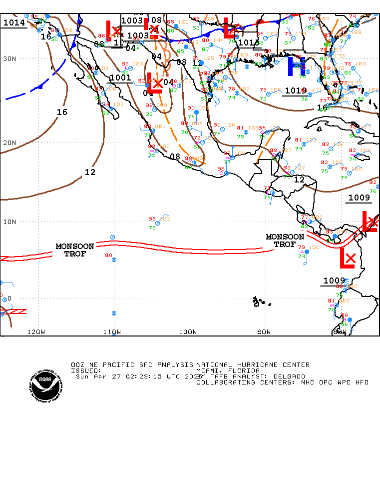
it does show a tropical wave in that area, but the nearest surface low is well displaced to the NW. Still, with that amount of convection going on, it could pull its act together fairly quickly.
0 likes
-
x-y-no
- Category 5
- Posts: 8359
- Age: 65
- Joined: Wed Aug 11, 2004 12:14 pm
- Location: Fort Lauderdale, FL
and from the discussion:
...TROPICAL WAVES...
A TROPICAL WAVE IS ALONG 93W TO THE S OF 14N AND HAS MOVED W AT
12 KT THE PAST 24 HOURS. THE WAVE IS EMBEDDED IN A BROAD AREA OF
LOW PRES THAT COVERS THE AREA FROM ROUGHLY 3N TO 13N BETWEEN
103W AND 83W. SEVERAL OTHER CYCLONIC SWIRLS ARE NOTED ON IMAGERY
INCLUDING ONE NEAR 11N99W THAT IS ANALYZED AS A SURFACE LOW PRES
1009 MB BUT IS DISORGANIZED. CURRENTLY SCATTERED MODERATE
ISOLATED STRONG CONVECTION OBSERVED WITHIN 90 NM OF 12N94W.
0 likes
-
cycloneye
- Admin
- Posts: 148791
- Age: 69
- Joined: Thu Oct 10, 2002 10:54 am
- Location: San Juan, Puerto Rico
I would not be surprised to see an invest later today as long the disturbance continues to organize.
0 likes
Visit the Caribbean-Central America Weather Thread where you can find at first post web cams,radars
and observations from Caribbean basin members Click Here
and observations from Caribbean basin members Click Here
Who is online
Users browsing this forum: Google Adsense [Bot] and 158 guests