Tim,
As far as I know, the NHC/TAFB folks have not mentioned this
particular storm system... meaning as far as they're concerned this
was an extratropical event. Of course, I could be wrong and I'll dig a
little deeper on the subject. I'm assuming you've read the case
study.. so.. that's the best reference that I know of that's out there
right now.. unless someone is actively (university grad student, govt.
or private sector) doing rsearch on it.. which is always a possibility.
My own thoughts are pretty much spelled out in the case review at:
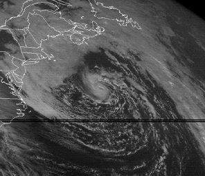
http://www.erh.noaa.gov/mhx/06May2005/050605event.htmlA few more thoughts for you.. since I know you love this type of
weather. There are several major differences between tropical and
extatropical systems. Here is the crash course, if you don't already
know...
Tropical systems form and maintain themselves in more or less
barotropic environments (environments that are fairly uniform in
temperature along a constant horizontal pressure surface) and derive
their energy from the latent heat release of organized clusters of
thunderstorms (tropical waves) in the low tropical latitudes that are
10+ degrees N or S of the equator where the coriolis effect is strong
enough to cause that essential cyclonic curvature). Latent heat
release occurs when water vapor condenses into liquid water droplets
as moist air in the thunderstorms is forced to rise and cool to its
lifted condensation level (LCL). If conditions are right.. i.e. warm
water (80+ F) and weak wind shear aloft...an inital tropical wave may
soon become an efficient heat engine that results in a feedback loop
where latent heat release warms the atmosphere and causes the surface
pressure beneath to drop (warm air is less dense, lower pressure
beneath a warmer column of air)...resulting in a stronger pressure
gradient at the surface...stronger winds/moisture inflow into the
system... more fuel (in the form of moisure/subsequent latent heat
release)...which in turn warms the atmosphere more and keeps dropping
the surface pressure...increasing the winds/moisture transport...and
so on and so forth...this is where you can see the positive feedback
cycle kick in. Once an eye forms...the heat engine becomes even more
efficient as subsidence in the eye warms the air dry adiabatically as
it sinks and compresses...further warming the column of air in the
central core of convection and further dropping the surface pressures.
That is why these systems are called 'warm-core' systems.
Extratropical systems derive their energy from baroclinic
environments...that is...environments where there are large
temperature differences over short distances along a constant pressure
surface (usually in the mid-latitudes ~30-50 degreees N or S of the
equator). These systems have warm/cold fronts and are the result of
the stetching of pre-existing vorticity that exists along strong
temperature gradients (i.e. in the winter along the NC coast where
inland temps can be in the 30s and offshore temps in the gulf stream
just 100 miles away can be in the 70s). The stretching of this pre-
existing sfc vorticity is accomplished by positive vorticity advection
assoc/w upper-level systems such as 500 mb troughs, shortwaves, lows
and also via diffluence aloft assoc/w ageostropic circulations in jet
entrance and exits. Extratropical cyclogenesis can be looked at in
many different ways and it is pretty tough to describe it any more
than I have...and it would take much longer...and the description
above is pretty technical at the least. But basically...you need a
good surface temperature gradient and a potent upper-level system to
cross that gradient for an extratropical system to develop. These
systems are called 'Cold-Core' because these systems tilt W or NW with
height connecting to the cold, upstream upper-level trough or low.
As you can see, they are both very complicated weather systems...and
there are two extreme ends of the spectrum.. purely tropical and
purely extratropical.. with a lot of room in-between for storms to
have characteristics for both given the right conditions. I'll have to
take a more detailed look at the data again, but I'd say this was a
storm that definitely fell in-between the tropical and extratropical
spectrum. If the experts over at NHC haven't mentioned anything about
it...then most likely it didn't meet their criteria for subtropical
storms...or in other words it wasn't close enough to the tropical end
of the spectrum to start it as such.