Atlantic/Pacific SSTs/Anomalies=South Pacific Neg PDO

This is the general tropical discussion area. Anyone can take their shot at predicting a storms path.

Moderator: S2k Moderators

Forum rules

The posts in this forum are NOT official forecasts and should not be used as such. They are just the opinion of the poster and may or may not be backed by sound meteorological data. They are NOT endorsed by any professional institution or STORM2K. For official information, please refer to products from the National Hurricane Center and National Weather Service.

Help Support Storm2K
Message
Author
MiamiensisWx

Atlantic/Pacific SSTs/Anomalies=South Pacific Neg PDO

#1 Postby MiamiensisWx » Mon Jan 02, 2006 2:06 pm

This thread is for discussing about current trends in SSTs and SST anomalies in the Atlantic Ocean and Pacific Ocean. Since the 2006 season is soon coming up, now is the perfect time to monitor SST anomaly trends in the Atlantic and Pacific to determine if conditions are trending toward neutral or El Nino or La Nina conditions. These factors will play an important part in how 2006 will go in terms of tropical activity, although they are only a few factors. Now is the time to monitor SST trends! Thoughts, comments, and discussions are welcome!

Currently, SST anomalies have cooled hugely in the Atlantic over the past few weeks. Even the area of high SST anomalies off Africa has cooled significantly. See below...

Image

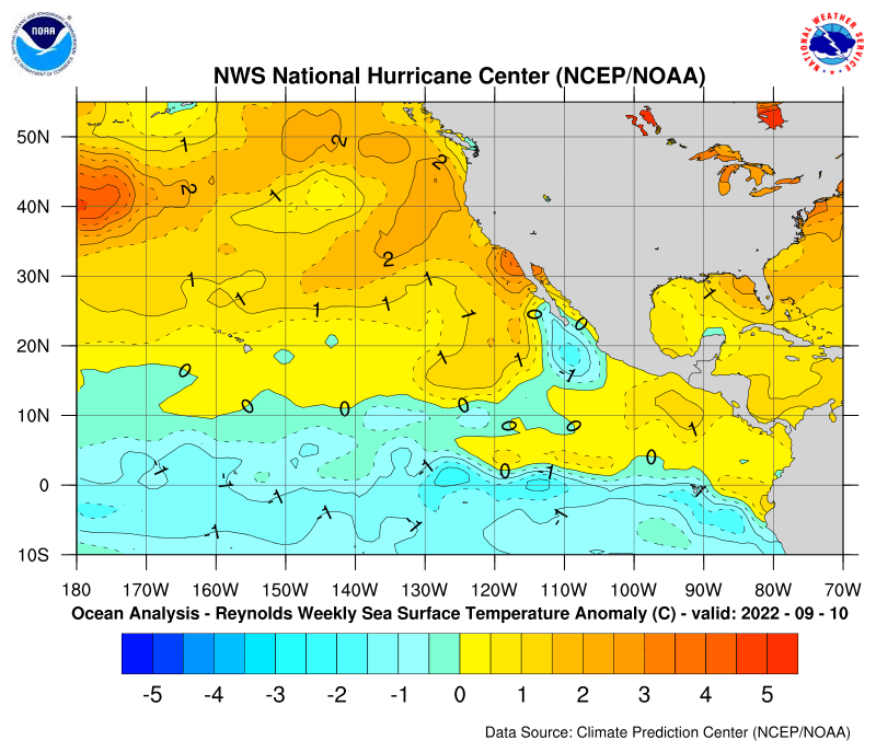
Meanwhile, the Pacific SST anomalies have warmed over the past few weeks. The areas of cooler SST anomalies are getting warmer and smaller right now as well. See below...
Image

Currently, this qualifies as neutral conditions. With these trends, however, a La Nina is starting to look less likely, while neutral conditions or an El Nino are increasing in probability. If these trends continue, an El Nino may very well occur.

Will an El Nino develop? Stay tuned! Thoughts, comments, and discussions are welcome! This will now be the official SST discussion and monitoring thread! Your thoughts are welcome!
Last edited by MiamiensisWx on Sat Jan 07, 2006 12:28 pm, edited 5 times in total.
0 likes   

MiamiensisWx

#2 Postby MiamiensisWx » Mon Jan 02, 2006 2:14 pm

Scorpion, we can continue our SST discussion here!
0 likes   

Scorpion

#3 Postby Scorpion » Mon Jan 02, 2006 2:24 pm

While the SSTA's in the Atlantic have cooled the SSTA's in the Pacific have barely warmed. Last year in the Pacific in April we were talking about +3 or greater anomolies in the Pacific, right now they are normal to below normal. So a neutral year is likely, but a slight Nina isn't out of the question.
0 likes   

MiamiensisWx

#4 Postby MiamiensisWx » Mon Jan 02, 2006 2:26 pm

Scorpion wrote:While the SSTA's in the Atlantic have cooled the SSTA's in the Pacific have barely warmed. Last year in the Pacific in April we were talking about +3 or greater anomolies in the Pacific, right now they are normal to below normal. So a neutral year is likely, but a slight Nina isn't out of the question.


True... however, it is still early. Also, look at the trends. A month ago, SST anomalies in the Pacific were more below average than they are now. Also, SST anomalies in the Atlantic have exhibited rapid cooling, in tandem with the warming of Pacific SST anomalies. I agree... for now, it looks like more of a neutral year, with an El Nino becoming more possible. You need to look at trends, Scorpion.
0 likes   

User avatar
cycloneye
Admin
Admin
Posts: 146225
Age: 69
Joined: Thu Oct 10, 2002 10:54 am
Location: San Juan, Puerto Rico

#5 Postby cycloneye » Mon Jan 02, 2006 2:30 pm

CapeVerdeWave I took out the word official at the title of this thread as you know there is my thread at tropical analysis forum where I go in more detail about the sst's and ssta's in both the Atlantic and Pacific.
0 likes   
Visit the Caribbean-Central America Weather Thread where you can find at first post web cams,radars
and observations from Caribbean basin members Click Here

MiamiensisWx

#6 Postby MiamiensisWx » Mon Jan 02, 2006 2:31 pm

That's fine, cycloneye! Good!
0 likes   

MiamiensisWx

#7 Postby MiamiensisWx » Tue Jan 03, 2006 2:40 pm

*BUMP*

Come on! Let's discuss SST trends here!
0 likes   

User avatar
wxmann_91
Category 5
Category 5
Posts: 8013
Age: 34
Joined: Fri Jul 15, 2005 2:49 pm
Location: Southern California
Contact:

#8 Postby wxmann_91 » Tue Jan 03, 2006 7:13 pm

The anomalies have cooled in the CPAC. That could be good news for next hurricane season.
0 likes   

MiamiensisWx

#9 Postby MiamiensisWx » Tue Jan 03, 2006 7:53 pm

wxmann_91 wrote:The anomalies have cooled in the CPAC. That could be good news for next hurricane season.


Huh? Don't you mean that SST anomalies in the central Pacific have warmed instead?
0 likes   

User avatar
wxmann_91
Category 5
Category 5
Posts: 8013
Age: 34
Joined: Fri Jul 15, 2005 2:49 pm
Location: Southern California
Contact:

#10 Postby wxmann_91 » Tue Jan 03, 2006 7:58 pm

CapeVerdeWave wrote:
wxmann_91 wrote:The anomalies have cooled in the CPAC. That could be good news for next hurricane season.


Huh? Don't you mean that SST anomalies in the central Pacific have warmed instead?


Actually, no. During most of the past two years, the north central Pacific has been much warmer than usual. This, according to Dr. Gray, set up a longwave pattern that made the ridge along the east coast anomalously strong, steering hurricanes toward the U.S.
0 likes   

MiamiensisWx

#11 Postby MiamiensisWx » Tue Jan 03, 2006 8:00 pm

wxmann_91 wrote:Actually, no. During most of the past two years, the north central Pacific has been much warmer than usual. This, according to Dr. Gray, set up a longwave pattern that made the ridge along the east coast anomalously strong, steering hurricanes toward the U.S.


True... however, I thought that SST anomalies in the Pacific are now starting to warm instead! I checked the latest SST anomaly graphics, and it shows warming Pacific SST anomalies and cooling Atlantic SST anomalies. Please reply!
0 likes   

User avatar
wxmann_91
Category 5
Category 5
Posts: 8013
Age: 34
Joined: Fri Jul 15, 2005 2:49 pm
Location: Southern California
Contact:

#12 Postby wxmann_91 » Tue Jan 03, 2006 8:03 pm

CapeVerdeWave wrote:
wxmann_91 wrote:Actually, no. During most of the past two years, the north central Pacific has been much warmer than usual. This, according to Dr. Gray, set up a longwave pattern that made the ridge along the east coast anomalously strong, steering hurricanes toward the U.S.


True... however, I thought that SST anomalies in the Pacific are now starting to warm instead! I checked the latest SST anomaly graphics, and it shows warming Pacific SST anomalies and cooling Atlantic SST anomalies. Please reply!


Yes... however, the area between 30 and 40 N has cooled significantly, now to negative anomaly. South of that is a patch of warm water, but from my vantage point it's a lot smaller than what I saw in November. Anybody got a link for entire Pacific SST anomalies (with archives to a few months back)?
0 likes   

Wirbelsturm
Tropical Low
Tropical Low
Posts: 33
Joined: Mon Oct 17, 2005 11:06 am
Location: Central Kentucky

#13 Postby Wirbelsturm » Tue Jan 03, 2006 8:30 pm

Sent by Carmeyia Gillis of CPC.

The following are some bullets that CPC prepared with regards to the developing La Nina.


1) Based on current conditions in the tropical Pacific, the most recent SST predictions, and on results from historical studies on the effects of cold episodes, we expect wetter-than-normal (drier-than-normal) conditions to prevail over Indonesia (the central equatorial Pacific) during the remainder of the NH winter.

2) That pattern of tropical precipitation favors a northward shift in the position of the jet stream over the eastern North Pacific during winter, which is usually accompanied by drier than average conditions over southern California and Arizona.

3) However, given the late onset of La Niña, there is considerable uncertainty as to whether or not typical La Niña effects will be experienced in the West this winter.

4) The JFM seasonal outlook and discussion increases the likelihood of "drier than normal conditions over much of the southern third of the CONUS." Many of the seasonal forecasting tools lean toward this dryness, which is a consistent response to weak La Nina conditions.

5) Recent and expected rains in the NW CONUS are typical of winter, and not necessarily driven by La Nina.

6) The persistent pattern which has been delivering below normal temperatures to the East (+ PNA and -AO) is trending toward moderation in the models into week-2, as we approach the end of CY2005.
La Nina on the way...or here already.
0 likes   

MiamiensisWx

#14 Postby MiamiensisWx » Sat Jan 07, 2006 12:25 pm

*BUMP*
0 likes   


Return to “Talkin' Tropics”

Who is online

Users browsing this forum: Google Adsense [Bot], ljmac75 and 74 guests