Weather in Croatia:Goodbye 2013

Weather events from around the world plus Astronomy and Geology and other Natural events.

Moderator: S2k Moderators

Forum rules

The posts in this forum are NOT official forecast and should not be used as such. They are just the opinion of the poster and may or may not be backed by sound meteorological data. They are NOT endorsed by any professional institution or STORM2K.

Help Support Storm2K
Message
Author
User avatar
Crostorm
Category 5
Category 5
Posts: 2060
Age: 49
Joined: Mon Dec 25, 2006 3:51 pm
Location: Croatia-Europe
Contact:

Re: Weather in Croatia and Italy

#101 Postby Crostorm » Tue Oct 21, 2008 5:37 pm

Tornado
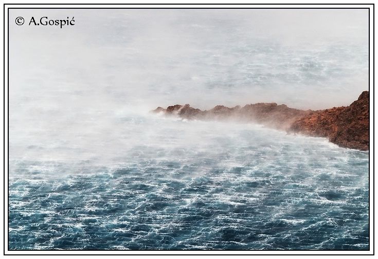
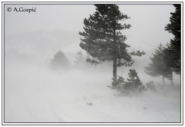
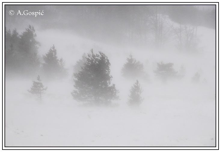
13.07.2008 - Medvode / Slowenien(Pictures and videos)

http://www.skywarn.de/forum/viewtopic.php?f=30&t=5767


Image
0 likes   

User avatar
Crostorm
Category 5
Category 5
Posts: 2060
Age: 49
Joined: Mon Dec 25, 2006 3:51 pm
Location: Croatia-Europe
Contact:

Re: Weather in Croatia and Europe

#102 Postby Crostorm » Sun Oct 26, 2008 2:15 pm

Some severe weather coming to Croatia,


The first wave of stronger precipitation over Istria on Tuesday evening
Image

The next wave is strong, night from Wednesday to Thursday
Image

And after that fairy tale on Friday, the cyclone comes from Italy
Image

Friday morning, exactly 994 hPa over Istria
Image

Of course all this is accompanied with plenty of rainfall
Image

And finally the wind, whose average speed exceeds 20 m / s
Image
0 likes   

User avatar
Crostorm
Category 5
Category 5
Posts: 2060
Age: 49
Joined: Mon Dec 25, 2006 3:51 pm
Location: Croatia-Europe
Contact:

Re: Weather in Croatia and Europe

#103 Postby Crostorm » Sun Nov 23, 2008 8:42 am

min temperature this morning in Croatia

Image

min temperature in Slovenia

Vrijeme po Sloveniji u 8. sati
Bilje pri N.Gorici - vedro - (-6C)
Celje - vedro - (-6C)
Let. J.Pucnika Lj. - vedro - (-5C)
Let.Cerklje ob Krki - vedro - (-6C)
Let. E.Rusjana MB - vedro - (-3C)
Letališce Portorož - vedro - (-2C)
Lisca - vedro - (-2C)
Ljubljana - vedro - (-3C)
Murska Sobota - djelomicno oblacno - (-3C)
Novo mesto - (-4C)
Triglav Kredarica - pretežno vedro - (-16C)

Snow report from Croatia-Dalmatian coast -Split(21.11.2008)

http://www.crometeo.net/site/index.php? ... user_op=...

Sutina

http://crometeo.net/phpbb/viewtopic.php?t=4838

Gradiste

http://crometeo.net/phpbb/viewtopic.php?t=4843

Bosnia and Herzegovina

Dubica
http://crometeo.net/phpbb/viewtopic.php?t=4840
Sarajevo
http://crometeo.net/phpbb/viewtopic.php?t=4841
Bosanski Petrovac
http://crometeo.net/phpbb/viewtopic.php?t=4839
0 likes   

User avatar
Crostorm
Category 5
Category 5
Posts: 2060
Age: 49
Joined: Mon Dec 25, 2006 3:51 pm
Location: Croatia-Europe
Contact:

Re: Weather in Croatia and Europe

#104 Postby Crostorm » Mon Nov 24, 2008 4:46 am

Image
0 likes   

User avatar
Crostorm
Category 5
Category 5
Posts: 2060
Age: 49
Joined: Mon Dec 25, 2006 3:51 pm
Location: Croatia-Europe
Contact:

Re: Weather in Croatia and Europe

#105 Postby Crostorm » Mon Nov 24, 2008 9:05 am

Slovenia *641

Image
Image
Image
Image
Image

ljubljana(log)
0 likes   

User avatar
Crostorm
Category 5
Category 5
Posts: 2060
Age: 49
Joined: Mon Dec 25, 2006 3:51 pm
Location: Croatia-Europe
Contact:

Re: Weather in Croatia and Europe

#106 Postby Crostorm » Mon Nov 24, 2008 10:11 pm

Anomaly for Europe 16-22 november
Image
Image
Image
Image
0 likes   

User avatar
Crostorm
Category 5
Category 5
Posts: 2060
Age: 49
Joined: Mon Dec 25, 2006 3:51 pm
Location: Croatia-Europe
Contact:

Re: Weather in Croatia and Europe

#107 Postby Crostorm » Thu Nov 27, 2008 12:34 pm

Very stormy for Friday and Saturday

Image


7-day Meteogram for Split, Croatia
Lat:43.51 Lon: 16.45 Aver. Elev.: 61m.

http://freemeteo.com/default.asp?pid=15 ... id=3190261
0 likes   

User avatar
Crostorm
Category 5
Category 5
Posts: 2060
Age: 49
Joined: Mon Dec 25, 2006 3:51 pm
Location: Croatia-Europe
Contact:

Re: Weather in Croatia and Europe

#108 Postby Crostorm » Thu Nov 27, 2008 2:45 pm

Image

Storm Forecast
Valid: Fri 28 Nov 2008 06:00 to Sat 29 Nov 2008 06:00 UTC
Issued: Thu 27 Nov 2008 18:01
Forecaster: TUSCHY

SYNOPSIS

Another arctic outbreak is underway, although this time more to the west or just west of Europe. An extensive vortex establishes over Europe, resulting in unsettled conditions as numerous disturbances rotate around this feature. Cool and stable conditions prevail over E-Europe.

DISCUSSION

... Sicily, Italy ,Tyrrhenian Sea, and the Adriatic Sea ...

Generally speaking, all models converge to the solution of a developing surface depression just off the coast of NE-Algeria already during the early morning hours, moving slowly to the north, before it strikes a new path more to the NE. They also agree in timing and path solution as this feature crosses N-CNTRL Italy during the evening and night hours. However the strength of this low remains still uncertain with WRF/GME on the more intense side ( sub-990hPa pressure core between Corsica and Italy ), whereas the rest of the model pool sticks with the more conservative/weaker solutions. Not the best data coverage over Algeria could be one reason for the remarkable spread. Final strength of the surface depression is crucial for vigorousness of return flow and hence instability release over the forecast area.However, as even more conservative models show enough CAPE for sustained convection, confidence has increased during the past few runs that organized thunderstorms are possible in the highlighted area.

...Sicily and S-Italy ...

Thermal ridge over Sicily and S-Italy flattens out quite fast with strongest CIN values well to south of Sicily/S-Italy, so atmosphere will be weakly capped. Both scenarios, a persistent moisture advection in the broad warm sector and some cooling at mid-levels will be more than adequate for widespread 400-800 J/kg SBCAPE with MLCAPE values running a bit lower. On the contrary, WRF has well above 1kJ/kg CAPE, so we think that plenty of instability will be in place, especially offshore.

Focus for initiation is quite difficult, as intense 40-45m/s mid-level streak sneaks in from the SW already during the morning hours, so initiation should already occur over Sicily during the morning hours and S-Italy around noon, which is in line with most of the models. Thereafter, a slowly eastward propagating cold front crosses the area from the west, affecting Sicily between 09-18Z and S-Italy between 15Z-00Z. Thunderstorm coverage will be widespread.

Shear values are impressive! (What a surprise for the winter time). As mid-level jet approaches, DLS boosts to 30-45m/s and 0-3km shear values reach up to 20m/s, so developing thunderstorms will gain organisation right away. It looks like a multiple severe weather threat for the upcoming period. Initiation in the prefrontal warm sector should be more of isolated nature, so discrete thunderstorms are well possible in an environment with LCLs below 500m, LL shear above 10m/s and SRH1 values in excess of 200m^2/s^2. In combination with aforementioned intene DLS, the environment is favorable for LL/mid-level mesocyclones with an attendant tornado threat. Even LL CAPE release increases during the day and we can't exclude strong tornadoes with such a set-up. Large hail and severe wind gusts are also likely with those supercells.

In addition, the cold front will spread eastwards and environment remains favorable for all facets of severe weather.More front-parallel flow, persistent and moist inflow from the S and a strong/progressive vorticity lobe hint on a mixture of a rapidly eastward racing and a southward/back-building MCS over S-Italy at 18Z onwards with a more widespread severe wind gust threat especially over extreme SE-Italy where latest GFS runs constantly had 35-40m/s at 850hPa during the cold front passage. Thunderstorms will finally clear the area to the east/southeast after 00Z.

...Tyrrhenian Sea, CNTRL Italy and the N/CNTRL Adriatic Sea ...

A strong and progressive cold front will reach the coastal area of W-CNTRL Italy between 9-12Z from the WSW. Prefrontal, stable airmass is strongly sheared with SRH1 of 400-600m^2/s^2. Passage of cold front coincides with the arrivial of a well evolved dry slot and strong lift, so there is the concern of potential instability release along the cold front and enhanced thunderstorm evolution just along the backside of the boundary. Those storms could still take profit of the intense LL shear/ abundant 0-3km CAPE release and tornadoes would be possible also well inland despite rapidly diminishing CAPE. We want to examine further model data before updating/upgrading.

The same high-shear/moderate instability environment evolves over the Adriatic Sea and especially along the NE/E coast. Right now we are somewhat concerned about the intense convection over S-Italy and attendant anvil debris/weakening mid-level lapse rates, which could affect most parts of the CNTRL/S-Adriatic Sea, limiting thunderstorm chances. However modest MLCAPE over the N-Adriatic Sea looks likely during the evening hours, as mid-levels continue to cool down. Rapidly strengthening DLS to well above 30m/s permits rapid thunderstorm organisation and an attendant severe wind gust / large hail / isolated tornado threat.

An augmented waterspout risk exists for Corsica and surrounding areas during the morning and early afternoon hours due to weak background shear and steep LL lapse rates.
0 likes   

User avatar
Crostorm
Category 5
Category 5
Posts: 2060
Age: 49
Joined: Mon Dec 25, 2006 3:51 pm
Location: Croatia-Europe
Contact:

Re: Weather in Croatia and Europe

#109 Postby Crostorm » Fri Nov 28, 2008 11:38 am

Wind speed on dalmatian coast

62.0mph / 99.8km/h

Image
0 likes   

User avatar
Crostorm
Category 5
Category 5
Posts: 2060
Age: 49
Joined: Mon Dec 25, 2006 3:51 pm
Location: Croatia-Europe
Contact:

Re: Weather in Croatia and Europe

#110 Postby Crostorm » Fri Nov 28, 2008 2:41 pm

WEATHER REPORT ISSUED BY THE MARINE METEOROLOGICAL CENTER SPLIT
ON 28.11.2008 AT 1200 HOURS

WARNING
GUSTS OF SE WIND 40-60, IN PLACES TODAY UP TO 70 KNOTS. IN THE EXTREME NORTH OF THE ADRIATIC ALONG THE COAST GUSTS OF E and NE WIND 30-45 KNOTS. SEA 4-5, IN THE OPEN 5-6. A RISK OF THUNDERSTORMS.

SYNOPSIS
A low over the western Mediterranean is shifting toward the Adriatic.

WEATHER FORECAST FOR THE ADRITATIC FOR THE FIRST 12 HOURS
SE wind increasing to 16-34, locally in the open today up to 40 knots. In the extreme north of the Adriatic along the coast NE and E wind 12-24 knots. Sea 3-4, locally 4-5, and in the open 5-6. Visibility 10-20, in places with rain reduced to around 4 km. Cloudy with rain in places, then with isolated rain showers and thunder, particularly late in the day and during the night.

WEATHER FORECAST FOR THE NEXT 12 HOURS
Cloudy with rain in places. Near gale and gale force SE wind will turn during the forenoon to moderate to strong SW, then in the North and in a part of the Central Adriatic briefly to NW wind. Sea in the open up to rough. A little warmer.

PMC - Split
0 likes   

User avatar
Crostorm
Category 5
Category 5
Posts: 2060
Age: 49
Joined: Mon Dec 25, 2006 3:51 pm
Location: Croatia-Europe
Contact:

Re: Weather in Croatia and Europe

#111 Postby Crostorm » Fri Jan 09, 2009 5:36 pm

This morning temperature :cold: :froze:
Croatia

Code: Select all

Temperature zraka u 7 sati

-18  Zagreb-aerodrom, Lipik, Požega

-17  Daruvar, Gradište-Županja, Vinkovci

-16  Gospić, Slavonski Brod

-15  Gorice-Nova Gradiška

-14  Osijek, Osijek-aerodrom

-13  Bjelovar, Sisak, Zagreb-Maksimir

-12  Karlovac, Koprivnica, Križevci, Sljeme, Varaždin

-11  Krapina

-10  Bilogora, Parg-Čabar

 -8  Zagreb-Grič, Risnjak, Plitvička jezera

 -7  Otočac, Pazin

 -6  Ogulin

 -5  Knin, Sinj

 -4  Zavižan

 -2  Poreč, Rijeka, Senj

 -1  Imotski, Malinska, Šibenik

  0  Pula-aerodrom, Zadar-aerodrom, Pag

  2  Ploče, Rovinj-Sv.Ivan n/p, Split-aerodrom, Zadar

  3  Mali Lošinj, Rab, Split

  4  Kornati

  5  Dubrovnik-aerodrom, Hvar

  6  Makarska, Mljet

  7  Dubrovnik

  8  Komiža, Lastovo

10  Palagruža


Slovenija

Image
0 likes   

User avatar
Crostorm
Category 5
Category 5
Posts: 2060
Age: 49
Joined: Mon Dec 25, 2006 3:51 pm
Location: Croatia-Europe
Contact:

Re: Weather in Croatia and Europe

#112 Postby Crostorm » Fri Jan 09, 2009 5:39 pm

Image

Image


Image

...

Image
0 likes   

User avatar
Crostorm
Category 5
Category 5
Posts: 2060
Age: 49
Joined: Mon Dec 25, 2006 3:51 pm
Location: Croatia-Europe
Contact:

Re: Weather in Croatia and Europe

#113 Postby Crostorm » Fri Jan 09, 2009 5:55 pm

Temperature on 2 meters for this night

Image
0 likes   

Ed Mahmoud

Re: Weather in Croatia and Europe

#114 Postby Ed Mahmoud » Sat Jan 10, 2009 12:43 am

Any reports on recent Italian snows?
0 likes   

User avatar
Crostorm
Category 5
Category 5
Posts: 2060
Age: 49
Joined: Mon Dec 25, 2006 3:51 pm
Location: Croatia-Europe
Contact:

Re: Weather in Croatia and Europe

#115 Postby Crostorm » Sat Jan 10, 2009 3:33 pm

Continues to make very cold in central and eastern Europe. Friday was particularly icy Romania, where Miercurea Ciuc fell to -24.9 ° C and Mount Omu (2504 m) to -22.6 ° C. There are also (in brackets the average minimum in January), these minimum: -19.4 ° C Bacau, Sibiu -17.8 ° C (-8.3 ° C), Cluj-Napoca -15.3 ° C ( average -6.5 ° C), Bucharest -15.0 ° C (-5.5 ° C) -14.2 ° C Botosani, Iasi -13.6 ° C (-6.9 ° C).

Great frost in Slovakia. Bratislava has a minimum of -12.7 ° C, but Sliac fell to -20.5 ° C, Poprad to -17.9 ° C (-9.4 ° C, the average minimum in January) and Kosice to -17.8 ° C. All grossly negative, just entered the country in the eurozone, the maximum temperature. Very cool to Hungary, where Budapest fell to -9.9 ° C, but Debrecen and Szeged are precipitated to -16.7 ° and -15.4 ° C (12 ° and 11 ° C below their averages) .

Besides the snow in Madrid (which we have devoted an article in-depth), in Spain are to be reported very low temperatures reached in the "hot" Andalusia. Friday, January 9, -3.1 ° C above the minimum in Jerez de la Frontera (10 ° C maximum, already 0 ° C to 21 local), -2.6 ° C in Cordoba, "only" -0.1 ° C Granada (which is situated over 500 meters), 0 ° C to Seville (already returned, after a maximum of only 10 ° C, 3 ° C to 22 local).

Very cold in Portugal. Lisbon-Gago Cotinho Friday saw a minimum temperature of -0.1 ° C only 8.0 ° C maximum. The average January Lisbon are 8.2 ° / 14.5 ° C, the historical record is -1.2 ° C. 0.4 ° / 10.5 ° C in the extreme southern Faro, 7.7 ° / 16.1 ° C averages in January, -1.2 ° C, the historical record. Inland, Braganca has average January 0.5 ° / 8.4 ° C, the extreme heat Friday were -3.4 ° / 0.6 ° C and is drawn snowed. -0.6 ° / 3.3 ° C the extreme heat of Oporto, where he fell for several hours a cold rain, sometimes mixed with snow. The averages of the second Portuguese city is, to January, 5.1 ° / 13.5 ° C.

Friday, January 9, the three most cold Siberia were Ojmjakon, Verhojansk and Selagoncy Thursday, with minimal -51.4 °, -48.7 °, -46.9 ° C.

Image
0 likes   

User avatar
Crostorm
Category 5
Category 5
Posts: 2060
Age: 49
Joined: Mon Dec 25, 2006 3:51 pm
Location: Croatia-Europe
Contact:

Re: Weather in Croatia and Europe

#116 Postby Crostorm » Sat Jan 10, 2009 3:56 pm

Ed Mahmoud wrote:Any reports on recent Italian snows?


On south Italy is Flooding and in North ice

video
http://www.video.mediaset.it/mplayer.ht ... udioaperto
0 likes   

User avatar
Crostorm
Category 5
Category 5
Posts: 2060
Age: 49
Joined: Mon Dec 25, 2006 3:51 pm
Location: Croatia-Europe
Contact:

Re: Weather in Croatia and Europe

#117 Postby Crostorm » Sat Jan 10, 2009 7:33 pm

Today one of our member went on Plitvice Lake National Park and he made some outstanding pictures
The temperature where -15°C
Just look and enyoy
This picture is from summer time
Image

And this one in winter time

Image

Here are the rest of images
http://crometeo.net/phpbb/viewtopic.php?t=5109
0 likes   

User avatar
Crostorm
Category 5
Category 5
Posts: 2060
Age: 49
Joined: Mon Dec 25, 2006 3:51 pm
Location: Croatia-Europe
Contact:

Re: Weather in Croatia and Europe

#118 Postby Crostorm » Mon Jan 26, 2009 3:09 pm

0 likes   

User avatar
Crostorm
Category 5
Category 5
Posts: 2060
Age: 49
Joined: Mon Dec 25, 2006 3:51 pm
Location: Croatia-Europe
Contact:

Re: Weather in Croatia and Europe

#119 Postby Crostorm » Wed Feb 18, 2009 4:43 am

Its snoving in Croatia

Dalmatian coast Split

Image
0 likes   

User avatar
Crostorm
Category 5
Category 5
Posts: 2060
Age: 49
Joined: Mon Dec 25, 2006 3:51 pm
Location: Croatia-Europe
Contact:

Re: Weather in Croatia and Europe

#120 Postby Crostorm » Sun Dec 13, 2009 10:46 pm

The cyclone center will move over central and southern Italy in the southern Adriatic Sea during the Tuesday, 15.12. On its rear side will flow colder continental air, in combination with moisture in Croatia will fall first real winter snow in some places and over 20cm.

Image

Image

Image

Image
0 likes   


Return to “Global Weather”

Who is online

Users browsing this forum: No registered users and 1 guest