Page 1 of 1
Severe T-Storm Warning UPDATED
Posted: Fri Jun 08, 2007 2:47 pm
by dizzyfish
Yikes! I've been hearing it thunder for about 45 minutes now. That radar looks nasty.
Radar
http://radar.weather.gov/radar.php?rid= ... 11&loop=no
Text
http://www.srh.noaa.gov/showsigwx.php?w ... rm+Warning
Look out Rainband - it sounds like it is heading for us.
Posted: Fri Jun 08, 2007 3:13 pm
by dizzyfish
Just came out with a severe T-Storm warning for Pinellas and Hillsborough counties too.
http://www.srh.noaa.gov/tbw/html/tbw/
Posted: Fri Jun 08, 2007 3:16 pm
by JonathanBelles
Im in a SVR warning !!! yay. no rain yet. I just checked the warning and it is just north of me.
Posted: Fri Jun 08, 2007 3:20 pm
by JonathanBelles
There is a hail signature
Posted: Fri Jun 08, 2007 3:23 pm
by dizzyfish
Ours was a bust. Lots of lightning but little rain. Maybe a tenth. Still hear some thunder.
Posted: Fri Jun 08, 2007 3:33 pm
by JonathanBelles
SEVERE WEATHER STATEMENT
NATIONAL WEATHER SERVICE TAMPA BAY AREA - RUSKIN FL
428 PM EDT FRI JUN 8 2007
FLC057-103-082045-
/O.CON.KTBW.SV.W.0062.000000T0000Z-070608T2045Z/
PINELLAS-HILLSBOROUGH-
428 PM EDT FRI JUN 8 2007
...A SEVERE THUNDERSTORM WARNING REMAINS IN EFFECT UNTIL 445 PM EDT
FOR WESTERN HILLSBOROUGH AND CENTRAL PINELLAS COUNTIES...
AT 428 PM EDT...A SKYWARN SPOTTER REPORTED PENNY SIZE HAIL NEAR THE
ST PETE CLEARWATER INTERNATIONAL AIRPORT.
NATIONAL WEATHER SERVICE DOPPLER RADAR INDICATED THE SEVERE
THUNDERSTORM WAS NOW 5 MILES EAST OF PINELLAS PARK...MOVING SOUTHWEST
AT 5 MPH.
THE SEVERE THUNDERSTORM WILL BE NEAR...
FEATHER SOUND.
PINELLAS PARK.
MOVE INTO A STURDY BUILDING IMMEDIATELY!
PLEASE REPORT TORNADOES OR FUNNEL CLOUDS...WINDS OF 58 MPH OR
HIGHER...HAIL THE SIZE OF PENNIES OF LARGER...AND ANY WIND DAMAGE TO
YOUR NATIONAL WEATHER SERVICE IN RUSKIN BY CALLING 813-645-2323.
&&
Posted: Fri Jun 08, 2007 3:45 pm
by tbstorm
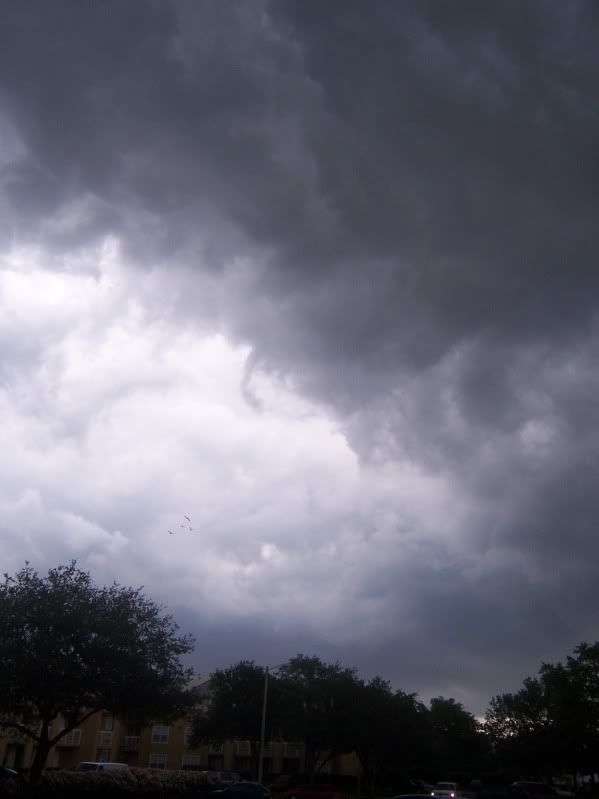
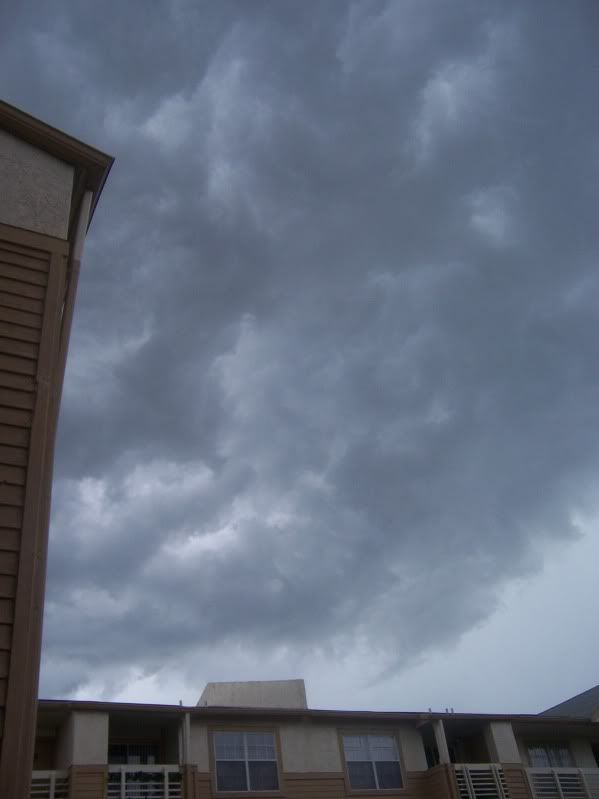
Hey everyone! Nice storm. Here's a couple of pics of the outflow/shelf cloud as it moved over S. Tampa about 430p
Posted: Fri Jun 08, 2007 3:58 pm
by tbstorm
There is a nice outflow boundary moving from about Brandon NE into Polk County N of Lakeland... this is the area to watch for new storms
Posted: Fri Jun 08, 2007 4:26 pm
by JonathanBelles
That storm had a weird track, It started in Old Tampa Bay and then moved Se and then SW and out of Tampa Bay, right around Pinellas County!!
Posted: Fri Jun 08, 2007 5:13 pm
by feederband
Thought we may miss out today...But now were being HAMMERED......I love the rainy season..
Posted: Fri Jun 08, 2007 5:28 pm
by JonathanBelles
Another line may come through here in about an hour.
Posted: Fri Jun 08, 2007 5:37 pm
by JonathanBelles
Hail Reports 6-8-2007
Time Size Location County State Lat Lon Comments
**1916 100 NORTH BLOCKS GOLDEN GAT COLLIER FL 2623 8154 QUARTER INCH HAIL OBSERVED ALONG WITH STRONG WINDS WHICH BLEW DOWN A 150 FOOT SECTION OF A FENCE. REPORT RELAYED BY WFO TBW. (MFL)
**1928 75 N LAND O' LAKES PASCO FL 2822 8245 THOMAS LAKE AREA. (TBW)
**2023 75 SAINT PETE CLEARWATER A PINELLAS FL 2791 8269 REPORTED ON ROAD NEAR AIRPORT (TBW)
**2129 175 HOLMES BEACH MANATEE FL 2751 8272 *** 1 INJ *** GUSTY WINDS AND GOLF BALL SIZE HAIL. CUT ABOVE RIGHT EYE. (TBW)
[hr]
Wind Reports 6-8-2007
Time Speed Location County State Lat Lon Comments
**1905 UNK CAPE CORAL LEE FL 2658 8199 POWER LINES DOWN. FIRE STARTED ON ONE HOME. TIME CHANGED BASED ON RADAR. (TBW)
**1920 UNK CAPE CORAL LEE FL 2658 8199 POWER LINES DOWN. FIRE STARTED ON ONE HOME. (TBW)
**1928 65 N LAND O' LAKES PASCO FL 2822 8245 NUMEROUS TREES DOWN AROUND THOMAS LAKE. (TBW)
**2010 UNK TOWN 'N' COUNTRY HILLSBOROUGH FL 2801 8258 TREE DOWN ON HOUSE ON CRESTVIEW DR. (TBW)
-updated 6:37edt-
Posted: Fri Jun 08, 2007 6:40 pm
by tbstorm
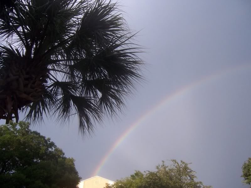
Feederband, those storms fired up right over Lakeland like I expected. I just the NWS site didnt see any storm reports though that looked like a hailer in the Green Swamp. Here's what they look like from Tampa looking east, now.
Mamatus

And a nice rainbow... too bad I couldnt it them all in the same shot
Posted: Fri Jun 08, 2007 7:13 pm
by BreinLa
These pictures are awesome thanks for sharing
Posted: Fri Jun 08, 2007 7:20 pm
by feederband
tbstorm wrote:Feederband, those storms fired up right over Lakeland like I expected. I just the NWS site didnt see any storm reports though that looked like a hailer in the Green Swamp. Here's what they look like from Tampa looking east, now.
Mamatus
And a nice rainbow... too bad I couldnt it them all in the same shot
We did have some hail about half a mile to my south..The lightning was the real story ...It really put on a show...
Posted: Fri Jun 08, 2007 7:38 pm
by tbstorm
BreinLa wrote:These pictures are awesome thanks for sharing
My pleasure! I love taking pictures of clouds and storms. trying to get some 'snaps of lightning but I havent quite figured out how to do it yet (the fish that got away...) The one on my sig is from video I shot.
I think it's cool to chat/post with people around experiencing the same weather but in different places in my area.