Page 1 of 2

Derecho in North Texas

Posted: Wed May 02, 2007 7:21 pm
by CrazyC83
http://media.myfoxdfw.com/live/severeweather2.html

Widespread wind damage reported - winds up to 100 mph...stretching from north of Dallas to south of Waco...

Posted: Wed May 02, 2007 7:23 pm
by JonathanBelles
I cant get the video to work.

Posted: Wed May 02, 2007 7:27 pm
by CrazyC83
Oh we'll find out on the news soon enough. Probably hundreds of thousands without power.

Posted: Wed May 02, 2007 7:29 pm
by srainhoutx
live streaming via http://www.wfaa.com if interested...

Posted: Wed May 02, 2007 7:31 pm
by JenBayles
From the above WFAA link: WOW!

There are reports of water eight to 10 inches deep in the inside lanes of I-30 near Hulen in Fort Worth. Our Weather Watcher in Dalworthington Gardens reports 2.30 inches of rain in a period of 30 minutes and it is still coming down. This is also a serious flooding situation; and if you don’t have to get out, you should just stay put this evening. New Severe Thunderstorm Warnings have been issued for Delta, Hopkins, Hunt, Rains and Van Zandt counties until 8:45 p.m.

Posted: Wed May 02, 2007 7:33 pm
by JonathanBelles
the WFAA vidoe keeps loading and loading...

Posted: Wed May 02, 2007 7:34 pm
by CrazyC83
They should replace the Tornado Watch with a PDS Severe Thunderstorm Watch...

Posted: Wed May 02, 2007 7:45 pm
by O Town
Just got this link from Catagory5 in another thread. 8 tornado reports, alot of hail reports and the wind reports are toward the bottom of the page. Alot of 60 and 70 MPH reports and I see one 80mph in Cleburne. Wow, TX got hammered today and is still getting some from the looks of radar.
http://www.spc.noaa.gov/climo/reports/today.html

Posted: Wed May 02, 2007 7:55 pm
by JonathanBelles
Those tornadoes are not in the last 3 hours: http://www.spc.noaa.gov/climo/reports/last3hours.html

Posted: Wed May 02, 2007 7:55 pm
by KatDaddy
Wow is right. This is a serious bow. Lets hope a it does not become derecho but has potential. A powerful bow currently

Posted: Wed May 02, 2007 8:06 pm
by CrazyC83
It already has produced destructive winds - widespread tree damage reported, structural damage, widespread power outages per TV coverage...reported winds to 100 mph (or more?)

New watch (IMO the wrong type) in the Arklatex area. I would have upgraded to MDT across the region, and killed the current Tornado Watch and put up a PDS Severe Watch with threat of 100+ mph winds.

Posted: Wed May 02, 2007 8:14 pm
by TexasStooge
100 MPH?!?! Looks more like a hurricane than a severe thunderstorm. Glad the power is still up and running here so far for my neighborhood.

Posted: Wed May 02, 2007 8:19 pm
by CrazyC83
TexasStooge wrote:100 MPH?!?! Looks more like a hurricane than a severe thunderstorm. Glad the power is still up and running here so far for my neighborhood.


Yep, it has the look and feel of a Category 2-3 hurricane...definitely a very dangerous and life-threatening situation if you are ahead of it...

Posted: Wed May 02, 2007 8:36 pm
by CrazyC83
What were the conditions ahead of the system? This seems like not exactly a classic setup for such a powerful derecho...

Posted: Wed May 02, 2007 8:56 pm
by Tampa Bay Hurricane
That's almost a Major Hurricane with winds over 100 mph!!! Very Scary!!!!

Posted: Wed May 02, 2007 9:08 pm
by Category 5
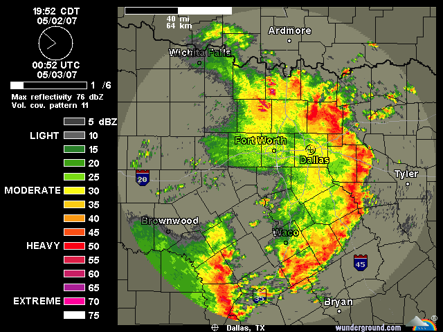
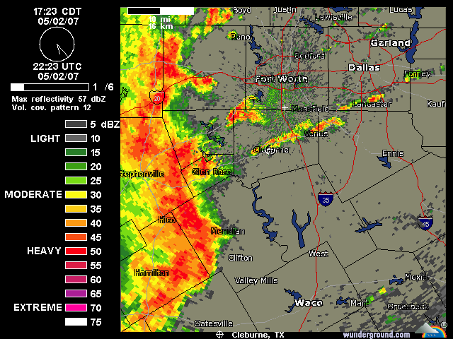
reports are pouring in
http://www.spc.noaa.gov/climo/reports/today.html


SEVERE WEATHER STATEMENT
NATIONAL WEATHER SERVICE FORT WORTH TX
902 PM CDT WED MAY 2 2007

TXC119-223-231-379-467-030245-
/O.CON.KFWD.SV.W.0171.000000T0000Z-070503T0245Z/
DELTA TX-HUNT TX-HOPKINS TX-RAINS TX-VAN ZANDT TX-
902 PM CDT WED MAY 2 2007

...A SEVERE THUNDERSTORM WARNING REMAINS IN EFFECT UNTIL 945 PM CDT
FOR EASTERN VAN ZANDT...RAINS...HOPKINS...NORTHEASTERN HUNT AND DELTA
COUNTIES...

AT 902 PM CDT...NATIONAL WEATHER SERVICE METEOROLOGISTS DETECTED LINE
OF SEVERE THUNDERSTORMS CAPABLE OF PRODUCING DESTRUCTIVE WINDS IN
EXCESS OF 70 MPH. THESE STORMS WERE LOCATED ALONG A LINE EXTENDING
FROM TIRA TO 33 MILES SOUTHEAST OF COMO TO 36 MILES SOUTHEAST OF
VAN...MOVING EAST AT 60 MPH. RADAR INDICATED STRONG WINDS BEHIND
THIS LINE OF THUNDERSTORMS THAT MAY CONTINUE TO CAUSE DAMAGE IN THE
WARNED AREA.

THE LINE OF SEVERE THUNDERSTORMS WILL OTHERWISE REMAIN OVER MAINLY
RURAL AREAS OF THE INDICATED COUNTIES.

HEAVY RAINS MAY FLOOD LOW LYING AREAS SUCH AS STREETS...DITCHES AND
UNDERPASSES. AVOID THESE AREAS AND DO NOT CROSS FLOODED ROADS AS THEY
MAY BE WASHED OUT.

THIS STORM HAS A HISTORY OF PRODUCING WIDESPREAD WIND DAMAGE. THIS IS
AN EXTREMELY DANGEROUS SITUATION. SEEK SHELTER NOW INSIDE A STURDY
STRUCTURE AND STAY AWAY FROM WINDOWS!

A TORNADO WATCH REMAINS IN EFFECT UNTIL 1000 PM CDT WEDNESDAY EVENING
FOR EASTERN TEXAS.

LAT...LON 3237 9582 3296 9588 3338 9616 3340 9587
3346 9585 3348 9579 3348 9560 3337 9530
3297 9531 3296 9566 3272 9564 3269 9560
3249 9560 3237 9548

Posted: Wed May 02, 2007 9:08 pm
by jasons2k
Earliest ones I could grab:

Image

Image

Posted: Wed May 02, 2007 9:11 pm
by Category 5
Image

Posted: Wed May 02, 2007 9:14 pm
by Category 5
Image

Posted: Wed May 02, 2007 9:19 pm
by Extremeweatherguy
CrazyC83 wrote:
TexasStooge wrote:100 MPH?!?! Looks more like a hurricane than a severe thunderstorm. Glad the power is still up and running here so far for my neighborhood.


Yep, it has the look and feel of a Category 2-3 hurricane...definitely a very dangerous and life-threatening situation if you are ahead of it...
Actually I believe those are 100mph+ gusts. Gusts of that magnitude are easily reached within a Category 1 hurricane. So far, I don't believe any place has seen Cat. 3 force winds out of this (111mph+ sustained) and I am skeptical about any place seeing Cat. 2 force sustained winds (96mph+) from this. Those type of winds are extremely rare to see in a sustained form from a thunderstorm...they were probably just gusts of Cat 2/3 strength. That is still incredible though for a line of storms! Any time 100mph+ gusts are produced, it is a very very serious event. I hope everyone is safe up there tonight!