Page 1 of 2
Severe Storms Tampa Bay Area-Hail, Damaging Winds
Posted: Wed Apr 11, 2007 7:15 pm
by tbstorm
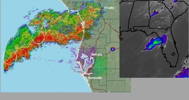
Just checking in looks like there is a little blow up of convection offshore the Nature Coast. NWS Tampa Bay has a special marine warning out for it; I wonder if this will hold through as it approaches the coast.
I overlaid the SRV and the BASE with photoshop and I did see some interesting areas offshore in the SRV, possible rotation in the gulf (white circled areas). Will track them, I wouldn't mind seeing a thunderstorm tonight.
700 PM EDT WED APR 11 2007
THE NATIONAL WEATHER SERVICE IN RUSKIN HAS ISSUED A
* SPECIAL MARINE WARNING FOR...
WATERS FROM TARPON SPRINGS TO SUWANNEE RIVER FL OUT 20 TO 60 NM.
COASTAL WATERS FROM TARPON SPRINGS TO SUWANNEE RIVER FL OUT 20 NM.
* UNTIL 830 PM EDT
* AT 700 PM EDT...NATIONAL WEATHER SERVICE DOPPLER RADAR INDICATED AN
AREA OF STRONG THUNDERSTORMS...WITH WIND GUSTS OVER 34 KNOTS...30
MILES WEST OF BAYPORT...MOVING EAST AT 30 KNOTS.
ANY OF THESE THUNDERSTORMS CAN PRODUCE A WATERSPOUT WITH LITTLE OR
NO ADVANCE WARNING. MARINERS CAN ALSO EXPECT LOCALLY HIGH
WAVES...DANGEROUS LIGHTNING...AND TORRENTIAL RAIN. SEEK SAFETY
IMMEDIATELY!.
Posted: Wed Apr 11, 2007 8:00 pm
by Extremeweatherguy
seems to be holding together pretty well based on the latest radar check.
Posted: Wed Apr 11, 2007 8:03 pm
by JonathanBelles
This looks like it might be falling apart closer to me.
Posted: Wed Apr 11, 2007 8:14 pm
by Tampa Bay Hurricane
Very Heavy Rain Just North of Tampa...some moderate rain is likely for saint petersburg...we have yet to see if any heavy
rain moves towards us in Saint Petersburg...but very heavy storms are occuring just north of Saint Petersburg
Posted: Wed Apr 11, 2007 8:18 pm
by tbstorm
We have an outflow boundary from Clearwater curving up to Wesley Chapel area. The storms are holding up in Pasco, and I am getting some beeps on my lightning detector (20-40 mile range from S. Tampa).
Looks like we will get some thunderstorms after all.
Posted: Wed Apr 11, 2007 8:18 pm
by JonathanBelles
Thats moving faster than I thought it was, possible heavy rain here WOOHOO
Posted: Wed Apr 11, 2007 8:25 pm
by JonathanBelles
Hillsborough and Pasco county are in a SVR
Posted: Wed Apr 11, 2007 8:27 pm
by Tampa Bay Hurricane
fact789 get ready for some big August Type Thunderstorms...Rainy Season wanted to give us a sneak preview.
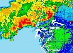
Folks it's going to get pretty rough in the next 2 hours here. I was looking at the base velocities and I am seeing possible gusts
to 60 mph with the offshore storms! Get Ready...an outflow boundary is moving SE from Clearwater's storms and will
likely generate more storms over Pinellas County and give Tampa Bay Wind Gusts of 40-50 mph if I am reading the velocities correctly.
Get ready for some wild weather folks.
Posted: Wed Apr 11, 2007 8:31 pm
by tbstorm
Oh yeah right on the outflow boundary. Classic. Possible hail in New Tampa, Central Pasco
Lightning is picking up here as well

* AT 921 PM EDT...NATIONAL WEATHER SERVICE DOPPLER RADAR INDICATED A
SEVERE THUNDERSTORM...CAPABLE OF PRODUCING PENNY SIZE HAIL...7
MILES WEST OF LUTZ...MOVING EAST AT 25 MPH.
Posted: Wed Apr 11, 2007 8:34 pm
by JonathanBelles
I do not have tornado detection capabillities, please post pics here if anything threatens.
Posted: Wed Apr 11, 2007 8:43 pm
by JonathanBelles
Tornado Warning for Pasco County!
Posted: Wed Apr 11, 2007 8:43 pm
by tbstorm
...Tornado Warning Dade City area
Posted: Wed Apr 11, 2007 8:46 pm
by MiamiensisWx
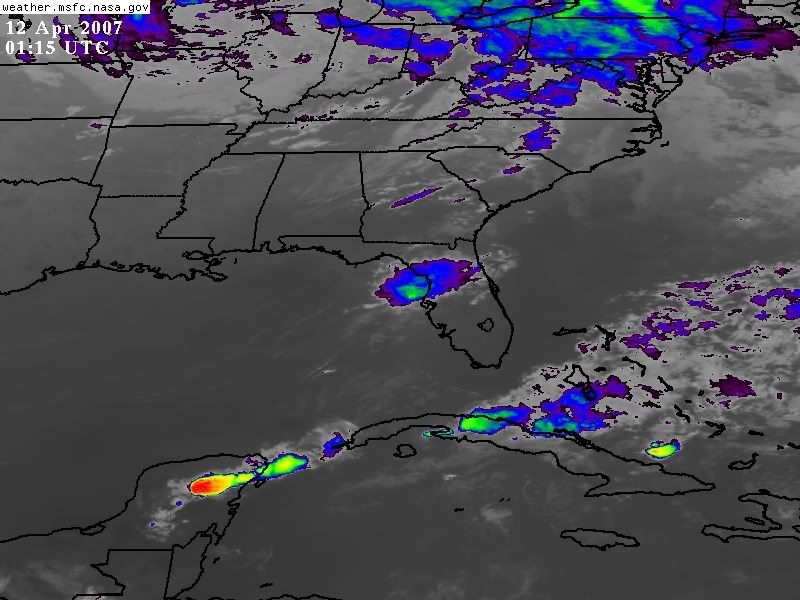
The southern end of the ejecting shortwave trough (assocoiated with an impressive mid-level trough over the Southeast) has enhanced the southwest and westerly return flow in the eastern Gulf of Mexico. Due to decent convergence, a classic outflow dominant squall line has developed with isolated individual supercells producing small hail and possible tornadoes as they move ashore. The overall coverage appears to be weakening as the best mid-level dynamics move east and northeast. You can see the progression on the
Tampa-Ruskin NWS radar loop.
Here is a good infra-red view of the southern end of the large system. Note the upper-level divergence and westerly surface flow that sparked severe weather over southwest Georgia and other portions of the Southeast. The tally has included a reported tornado near Birmingham, Alabama.
TORNADO WARNING
FLC101-120200-
/O.NEW.KTBW.TO.W.0005.070412T0140Z-070412T0200Z/
BULLETIN - EAS ACTIVATION REQUESTED
TORNADO WARNING
NATIONAL WEATHER SERVICE TAMPA BAY AREA - RUSKIN FL
940 PM EDT WED APR 11 2007
THE NATIONAL WEATHER SERVICE IN RUSKIN HAS ISSUED A
* TORNADO WARNING FOR...
NORTHEASTERN PASCO COUNTY IN FLORIDA.
* UNTIL 1000 PM EDT
* AT 940 PM EDT...NATIONAL WEATHER SERVICE DOPPLER RADAR INDICATED A
TORNADO OVER DADE CITY...MOVING EAST AT 30 MPH.
* THE TORNADO WILL BE NEAR...
DADE CITY NORTH BY 940 PM EDT.
PLEASE REPORT TORNADOES OR FUNNEL CLOUDS...WINDS OF 58 MPH OR
HIGHER...HAIL THE SIZE OF PENNIES OF LARGER...AND ANY WIND DAMAGE TO
YOUR NATIONAL WEATHER SERVICE IN RUSKIN BY CALLING 813-645-2323.
&&
LAT...LON 2845 8228 2828 8224 2832 8207 2843 8213
$$
57
http://www.srh.noaa.gov/tbw/html/tbw/
Posted: Wed Apr 11, 2007 8:46 pm
by Tampa Bay Hurricane
OK we have TORNADO WARNING IN PASCO AND SEVERE STORM WARNINS IN HILLSBOROUGH
Take SHELTER IF YOU ARE IN DADE CITY!!!!!
Posted: Wed Apr 11, 2007 8:53 pm
by MiamiensisWx
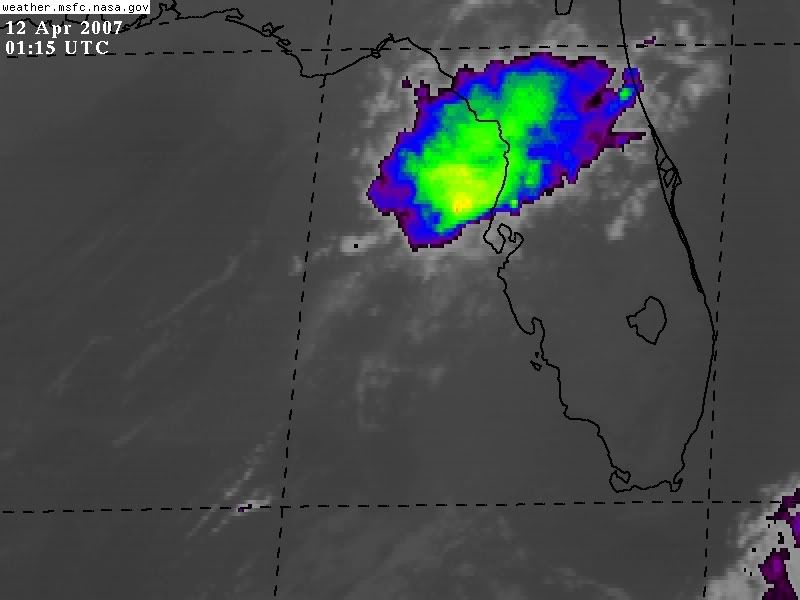
Here's another overhead infra-red shot indicating the low-level and upper-level divergence and surface convergence producing the broken squall line and supercells.
Posted: Wed Apr 11, 2007 8:54 pm
by JonathanBelles
When can I expect the worst?
Posted: Wed Apr 11, 2007 8:56 pm
by simplykristi
I would be getting off my pc and in a place of shelter if you are in harm's way!
Posted: Wed Apr 11, 2007 8:56 pm
by JonathanBelles
Its falling apart.
Posted: Wed Apr 11, 2007 8:57 pm
by tbstorm
Just getting the gust front now here in S, Tampa, 30 mph gusts so far... lightning has diminished here though.
Looks like that supercell is moving into S. Lake county... also getting word of SVR Tstorm Warning for W Orange County for this cell
* SEVERE THUNDERSTORM WARNING FOR...
SOUTHWESTERN LAKE COUNTY IN FLORIDA.
WESTERN ORANGE COUNTY IN FLORIDA.
Posted: Wed Apr 11, 2007 9:17 pm
by tbstorm
Watching a cell around Bradenton about to hit the outflow boundary from these storms near the Skyway, moving NE... this could be our next svr. storm.
And getting word of damage in Dade City where the Tornado Warning was earlier.
0955 PM TSTM WND DMG DADE CITY 28.36N 82.20W
04/11/2007 PASCO FL BROADCAST MEDIA
TREES AND WIRES KNOCKED DOWN AT ROSE AVENUE AND 14TH
STREET IN DADE CITY.