Possible Southeast severe threat today and tomorrow
Posted: Wed Apr 11, 2007 2:40 pm
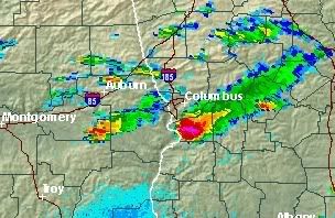
With a 990 mbar surface low located over central Missouri and Illinois and associated surface front trailing southward along the interior of a weak dry slot, localized instability may produce severe thunderstorms over the interior Southeast behind a mid-level trough and shortwave. The area at risk are western Tennessee and southwest Kentucky, northern and central Alabama and portions of Missouri, central and eastern Arkansas, the southern portions of Ohio and Indiana, and extreme northwest Georgia. Due to isolated cumulus fields on the south side of the low-level flow around the surface low, instability may be hindered in regions further west just behind the surface frontal boundary.
Due to decent surface temperatures and mid-level convergence and divergence at the upper levels within the warm sector (notably behind the departing shortwave), low-topped supercell development may be possible within the risk area (especially further east).

Due to decent surface temperatures and mid-level convergence and divergence at the upper levels within the warm sector (notably behind the departing shortwave), low-topped supercell development may be possible within the risk area (especially further east).