Page 1 of 1
Severe weather outbreak? On the 33rd Anniversary...
Posted: Sun Apr 01, 2007 11:05 pm
by CrazyC83
...of the biggest outbreak of all time.
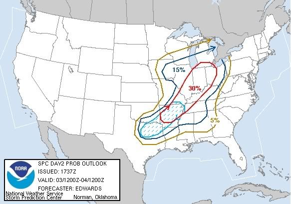
Models are showing a potential for a major outbreak this Tuesday, April 3, perhaps into Wednesday, April 4. Another Super Outbreak? Not likely, but still a major outbreak and a wide-ranging one.
Posted: Mon Apr 02, 2007 3:51 pm
by HarlequinBoy
So far, from what I've been reading/hearing, the main threat seems to be extensive damaging winds and further south the threat for large hail also increases. I don't really know that much about the tornado threat for tomorrow though.
Posted: Mon Apr 02, 2007 8:08 pm
by CrazyC83
I'm hearing conflicting things. The models are all over the map right now...
Posted: Tue Apr 03, 2007 5:39 pm
by simplykristi
We had storms roll thru this morning. In fact, lightning hit the car dealership where two of my brothers and oldest niece work. Thankfully, my oldest brother, who is the GM, went in early this morning and unfortunately discovered a fire in the service area. The fire would have not been discovered for at least another hour or so if he had not gone in early this AM. No power at the dealership tho.
When I took my dog out at 6:20 AM, it was a light show to my north. Then we got a fast-moving storm that rolled thru,
My weather radio alarm went off at 5:15 this AM for a severe thunderstorm warning in Douglas County KS and Jefferson County KS.
Posted: Tue Apr 03, 2007 6:12 pm
by CrazyC83
This has to be one of the most confusing weather events I can remember. It is trying to be so many things in different areas yet can only put down hail...there are signs of squall lines, supercells, derecho trying to form for a while, tornado outbreak seemed possible a while ago...
Posted: Tue Apr 03, 2007 6:26 pm
by HarlequinBoy
Sorry about the lightning and fire simplykristi, but I'm glad to hear no one was hurt.
We're under a tornado watch right now, but today has been a wonderful day weatherwise with very warm and sunny conditions, it's been really windy too. The local media has been reporting that a tornado touched down in Clay County, Arkansas but they don't report any damage.. and the NWS also reports a tornado report near Rector, AR but no damage reported.
So far it mostly looks like a lot of hail is moving across the area with an isolated tornado.
Posted: Tue Apr 03, 2007 6:31 pm
by Bunkertor
Really big echos, Caps seem to be very robust.
Posted: Tue Apr 03, 2007 7:09 pm
by pojo
We are going to have a nice cluster of storms come through the Little Rock area in the next few minutes... This will be an interesting light show.
Posted: Tue Apr 03, 2007 7:15 pm
by HarlequinBoy
Have fun and stay safe pojo!
...A TORNADO WARNING REMAINS IN EFFECT UNTIL 715 PM CDT FOR CRAIGHEAD
COUNTY...
AT 702 PM CDT...TRAINED WEATHER SPOTTERS REPORTED A TORNADO. THIS
TORNADO WAS LOCATED NEAR LAKE CITY...MOVING EAST AT 35 MPH.
OTHER LOCATIONS IN THE WARNING INCLUDE BUT ARE NOT LIMITED TO BLACK
OAK...MONETTE AND CARAWAY.
.IN ADDITION TO THE TORNADO...THIS STORM IS CAPABLE OF PRODUCING
GOLFBALL SIZE HAIL AND DESTRUCTIVE STRAIGHT LINE WINDS.
0654 PM TORNADO 1 E JONESBORO 35.82N 90.67W
04/03/2007 CRAIGHEAD AR TRAINED SPOTTER
JUST ON THE EAST SIDE OF JONESBORO
Posted: Tue Apr 03, 2007 7:21 pm
by pojo
HarlequinBoy wrote:Have fun and stay safe pojo!
...A TORNADO WARNING REMAINS IN EFFECT UNTIL 715 PM CDT FOR CRAIGHEAD
COUNTY...
AT 702 PM CDT...TRAINED WEATHER SPOTTERS REPORTED A TORNADO. THIS
TORNADO WAS LOCATED NEAR LAKE CITY...MOVING EAST AT 35 MPH.
OTHER LOCATIONS IN THE WARNING INCLUDE BUT ARE NOT LIMITED TO BLACK
OAK...MONETTE AND CARAWAY.
.IN ADDITION TO THE TORNADO...THIS STORM IS CAPABLE OF PRODUCING
GOLFBALL SIZE HAIL AND DESTRUCTIVE STRAIGHT LINE WINDS.
0654 PM TORNADO 1 E JONESBORO 35.82N 90.67W
04/03/2007 CRAIGHEAD AR TRAINED SPOTTER
JUST ON THE EAST SIDE OF JONESBORO
there is an evident sig radar... our storm is moving SE.... looks like it will miss LRAFB
Posted: Tue Apr 03, 2007 7:26 pm
by Category 5
How many severe thunderstorm warnings are out right now? 20?
Posted: Tue Apr 03, 2007 7:29 pm
by pojo
we have a lovely orangish color sky as the sun is setting and the rain/thunderstorms start moving in.
Posted: Tue Apr 03, 2007 7:36 pm
by breeze
We're bracing - the line looks to be pulling into the NW corner of TN, right now.
It'll probably roll through here between 9pm and 10pm.
~Annette~
Posted: Tue Apr 03, 2007 8:06 pm
by JonathanBelles
Just talked to my uncle in near Memphis, TN. He reported a dark, gloomy sky with a slight on and off drizzle. He did say, statlingly, that the sky was brown, red, and or purple at times. He is preparing for the worst.
Posted: Tue Apr 03, 2007 8:39 pm
by pojo
The storm is headed to the SE... there is a storm to the NW of Jacksonville that's heading SE... we'll probably get that... Right now its rain and lightning... some thunder
Posted: Tue Apr 03, 2007 9:33 pm
by HarlequinBoy
Local Tv mets in Memphis are saying there have been numerous reports of hail in northern part of Memphis called in over the past half hour.
Also a Tornado Warning is in effect of McNairy County, TN.
Here there's a spectacular lightning display to the north as the line sags southward. I think it has weakened as it's approached my area, but what's really neat is that the sky is very clear with tons of stars and then a lot of lightning coming from the north. I don't see that very often!
Also many reports of trees and powerlines down according to media in NE AR and NW TN from the storms, along with possible tornado damage in Craighead County.
Posted: Tue Apr 03, 2007 9:55 pm
by Category 5
Posted: Wed Apr 04, 2007 11:06 am
by Brent
Storms Damage Homes; Knocks Out Power
POSTED: 11:04 am EDT April 4, 2007
UPDATED: 12:01 pm EDT April 4, 2007
FLOWERY BRANCH, Ga. -- 11:55 UPDATE: Weather Service confirms 'micro-burst' damaged home; winds were up to 110 mph.
The storm that made its way across northeast Georgia packed hail, downed powerlines and trees, and damaged at least 35 houses in the Flowery Branch area of south Hall County.
Hall County Fire Marshall Scott Cagle says damage extends from shingles and vinyl siding being blown off to one house being destroyed.
The high winds blew that house off its foundation and split it right down the middle.
He says no injuries have been reported. Cagle says the people who live in the house that was destroyed are on spring break in Florida.
In north Forsyth County, pea-size hail covered yards after the storm; hail also was reported in Dawson County.
