


Even the 0z 5/23 GFS suggests a SIMILAR scenario, although the closed upper low on the GFS interpretation is weaker and the amplitude of the trof across the midwest appears to be somewhat more shallow than the ETA implies, with its double-contour closed 500mb low at 84hrs.


ECMWF idea supports both the GFS and ETA w/ the trof progressing into the EUS by FRI.
http://web.wright-weather.com/wxp-model ... 96_500.gif
http://web.wright-weather.com/wxp-model ... 20_500.gif
http://web.wright-weather.com/wxp-model ... 44_500.gif
Notice how the height field along the east coast is significantly lower than it is at the present time with 500mb heights as low as 582 DM into Northern FL by 12z FRI, and the persistent deep layer ridge along the SE coast is all but gone.
0z GGEM is similar at 12z WED w/ single contour cloased upper low off the CA coast and the trough progressing into the midwest....

Which by THU ends up in the lakes.

Same basic idea as the ECMWF had...which flattens the height field across the EUS, and gets rid of the pain in the arse deep layer ridging along the SE coast driving the pattern we're currently dealing with.
ditto that for the 0z UKMET
http://meteocentre.com/models/ukmet_ame ... _panel.gif
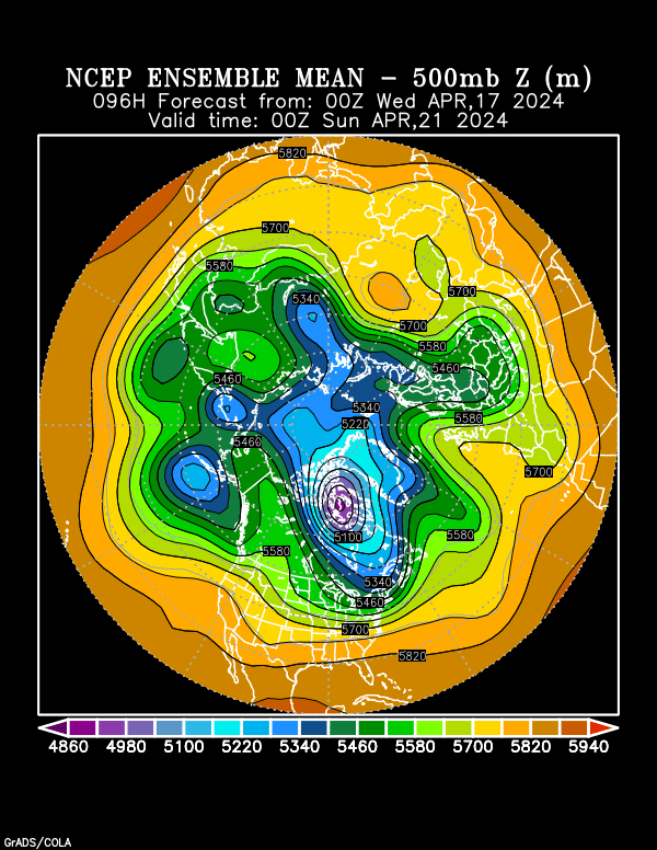
And GFS ensembles which HINT at the same thing. keep in mind though that because were dealing with the ENSEMBLE MEAN here, the amplitude of the trough over the midwest and the strength/position of the closed low off the CA coast wont be as defined as what they are on the operational model runs.
http://www.cdc.noaa.gov/map/images/ens/ ... 6_nhbg.gif

