November 17 Severe Weather & Tornado Outbreak

U.S. & Caribbean Weather Discussions and Severe Weather Events

Moderator: S2k Moderators

Forum rules

The posts in this forum are NOT official forecast and should not be used as such. They are just the opinion of the poster and may or may not be backed by sound meteorological data. They are NOT endorsed by any professional institution or STORM2K.

Help Support Storm2K
Message
Author
User avatar
TropicalAnalystwx13
Category 5
Category 5
Posts: 2109
Age: 26
Joined: Tue Jul 19, 2011 8:20 pm
Location: Wilmington, NC
Contact:

November 17 Severe Weather & Tornado Outbreak

#1 Postby TropicalAnalystwx13 » Fri Nov 15, 2013 11:25 pm

I'm surprised a thread hasn't been made yet.

Current Day 2 outlook:

Image

Note that this is from this morning. Model solutions from the NAM and SREF have trended slower and much more robust, indicating a much more substantial risk for severe weather. Wind shear is crazy high despite the marginal CAPE (1000-1250j/kg) on the latest NAM. Overall, conditions appear favorable for a few intense tornadoes across northern Illinois and Indiana as we head through Sunday mid-morning and early afternoon. It should evolve into a very intense squall line (maybe derecho?) that may produce hundreds of damaging wind reports given the low-level jet.
Last edited by TropicalAnalystwx13 on Sat Nov 16, 2013 3:31 pm, edited 1 time in total.
0 likes   

EF-5bigj
Category 3
Category 3
Posts: 864
Joined: Tue Feb 07, 2012 10:36 pm
Location: Spartanburg,SC

#2 Postby EF-5bigj » Sat Nov 16, 2013 12:37 am

Dixie alley again in the firing line I'll keep a eye on this.
0 likes   

User avatar
brunota2003
S2K Supporter
S2K Supporter
Posts: 9476
Age: 33
Joined: Sat Jul 30, 2005 9:56 pm
Location: Stanton, KY...formerly Havelock, NC
Contact:

#3 Postby brunota2003 » Sat Nov 16, 2013 3:24 am

JKL's (Jackson, KY) thinking on this. They don't seem super impressed with everything, as far as impacts to eastern KY go:

.SHORT TERM...(TODAY THROUGH SUNDAY NIGHT)
ISSUED AT 305 AM EST SAT NOV 16 2013

THE MODELS ARE IN GOOD GENERAL AGREEMENT WITH THE TIMING OF THE NEXT
SYSTEM. THE MODELS ARE SHOWING A PREFRONTAL BAND OF PRECIPITATION
MOVING THROUGH THE AREA TONIGHT. AND THEN HAVE A VERY POTENT COLD
FRONT MOVING ACROSS THE AREA ON SUNDAY EVENING. EACH PART OF THE
APPROACHING WEATHER HAS ITS FORECAST CHALLENGES. THE PREFRONTAL
PRECIPITATION WILL BE MOVING THROUGH WHEN THE ENVIRONMENT HAS SOME
GOOD ELEVATED INSTABILITIES. THE WIND SHEAR WILL BE VERY FAVORABLE
WITH SOME GOOD SPEED AND DIRECTIONAL SHEAR. ALL OF THESE FACTORS
WOULD BE VERY FAVORABLE FOR PRODUCING SEVERE THUNDERSTORMS. BECAUSE
THE INSTABILITY IN NOT SURFACE BASED AND BECAUSE OF THE TIME OF DAY
THAT THE SYSTEM IS MOVING THROUGH...ARE DETRACTORS FROM SEVERE
WEATHER. WITH THE LOW LEVEL INVERSIONS...IT WILL BE HARDER TO MIX THE
STRONGER WINDS DOWN. SPC HAS PUT THE BLUEGRASS IN A MODERATE RISK FOR
SEVERE THUNDERSTORMS AND THE REST OF EASTERN KENTUCKY IN A SLIGHT
RISK FOR SEVERE THUNDERSTORMS. MY ASSESSMENT IS THAT THE BLUEGRASS
WILL BE THE MOST LIKELY TO SEE ANY SEVERE THUNDERSTORMS
HOWEVER...THINK THAT IT IS MORE OF A SLIGHT RISK DUE TO THE ELEVATED
INSTABILITY AND TIME OF THE DAY. FOR THE REST OF EASTERN
KENTUCKY...THERE MAY BE A FEW SEVERE STORMS...HOWEVER DO NOT EXPECT
WIDESPREAD SEVERE THUNDERSTORMS. THE NEXT THING TO WORRY ABOUT IS THE
FRONTAL PASSAGE. THE GRADIENT OUT AHEAD OF THE FRONT IS FAIRLY
STRONG...SO EXPECTING SOME STRONG WIND GUSTS FROM AHEAD OF THE FRONT
TO ABOUT ONE HOUR PAST THE FRONTAL PASSAGE. THE MODELS ARE SHOWING
THE GRADIENT DECREASING AS THE FRONT MOVES ACROSS THE AREA...SO
EXPECT THE STRONGEST WINDS IN THE BLUEGRASS AND WEST OF I 75 AND THEN
DROPPING OFF SOME AS THE FRONT MOVES ACROSS THE AREA. BETWEEN THE TWO
DISTINCT EVENTS...EXPECT THE BEST CHANCE OF WIDESPREAD STRONG WIND
GUSTS TO BE WITH THE FRONT...HOWEVER THE STRONGEST GUST POTENTIAL
WILL BE WITH THE PREFRONTAL ACTIVITY. THE HOUR BY HOUR FORECAST WILL
SHOW THE TIMING OF THE FRONTAL PASSAGE.
0 likes   
Just a small town southern boy helping other humans.

User avatar
brunota2003
S2K Supporter
S2K Supporter
Posts: 9476
Age: 33
Joined: Sat Jul 30, 2005 9:56 pm
Location: Stanton, KY...formerly Havelock, NC
Contact:

#4 Postby brunota2003 » Sat Nov 16, 2013 3:30 am

LMK's (Louisville, KY) thinking on this. They seem a bit more impressed with everything, as far as impacts to central KY go (Note: my county is the western most for JKL, we border LMK):


.SHORT TERM (Now through Sunday Night)...
Issued at 300 AM EST Sat Nov 16 2013

Quite a few uncertainties still around about Sunday, but the
potential for several weather is still quite real. The Storm
Prediction Center has placed northern Kentucky and southern Indiana
within a moderate risk, highlighting a potential for damaging winds
and a few tornadoes. Recent guidance has come into good agreement
about the the track and the strengthening of a strong cyclone late
this weekend. All show a strong cyclonic upper jet carving a trough
across the upper Midwest late Sunday. Low pressure is forecast to
deepen to below 985mb as it tracks towards the Upper Peninsula of
Michigan by early Monday. A strong cold front is forecast to move
southeast of the Ohio River during the late evening hours on Sunday.

Low level winds will increase sharply by Sunday morning, providing
speed and directional shear adequate to support a potential for wind
damage and even a brief tornado or two. However, the potential for
severe weather will be tied to how much surface instability is
realized during the day on Sunday, and that is quite murky at this
point.

Leading up to Sunday, expect mostly cloudy skies, especially this
morning, with increasing southerly winds and very mild temperatures
this afternoon. Highs will reach the mid 60s with winds increasing
to 10 to 15 mph by noon. For tonight, warm temperatures
will continue, with a continued brisk southerly wind. Temperatures
won`t fall at much at all, bottoming out in the upper 50s. Highs
Sunday may potentially reach the lower 70s. Breezy to windy
conditions expected Sunday afternoon, with southerly winds between
20 and 25 mph, with some gusts up to 40 mph.

For Sunday, elevated thunderstorms will likely move into southern
Illinois and southwestern Indiana during the early morning hours,
likely overspreading much of central Kentucky by late morning.
Forecast 00z NAM soundings show elevated 925mb LI`s of -3. Although
elevated, some of these storms may produce small hail and gusty
winds. At some point Sunday, a break in precipitation will occur as
these initial storms race off towards the northeast. The 00z NAM is
much slower than the GFS and shows the development of a potentially
severe squall line during the afternoon or evening hours that would
approach from the northwest, affecting southwestern Indiana first.
If sufficient daytime heating produces adequate surface based
instability, this line could potentially produce widespread damaging
winds, with a potential for an isolated weak tornado embedded within
any bowing segments or mesoscale circulations.

Any convective line of storms will quickly race east of our area by
early morning Monday. West winds of 10 to 15mph with higher gusts
will arrive after midnight. Mostly clear skies anticipated by dawn
on Monday.
0 likes   
Just a small town southern boy helping other humans.

CrazyC83
Professional-Met
Professional-Met
Posts: 33399
Joined: Tue Mar 07, 2006 11:57 pm
Location: Deep South, for the first time!

#5 Postby CrazyC83 » Sat Nov 16, 2013 9:34 am

Still a lot of mode uncertainty. If enough instability can occur ahead of the front, we could see a tornado outbreak with supercells. Otherwise, an enormous squall line looks to be the greatest concern.
0 likes   

WeatherGuesser
Category 5
Category 5
Posts: 2672
Joined: Tue Jun 29, 2010 6:46 am

Re:

#6 Postby WeatherGuesser » Sat Nov 16, 2013 10:06 am

CrazyC83 wrote:Still a lot of mode uncertainty. If enough instability can occur ahead of the front, ...


Today's forecast was for at least partly sunny and around 70, but I'm not sure it'll get there, It's overcast and upper 50s right now. Still plenty of time to clear out and heat up, so we'll see, but if it stays like this, I don't see too much widespread trouble.

Also, it looks like they've kind of downgraded precip chances a bit and shifted the timing. They were at 70% for tomorrow and 80% for tomorrow night, now they're at 70% for tonight and 60% for tomorrow daytime.
0 likes   

User avatar
TropicalAnalystwx13
Category 5
Category 5
Posts: 2109
Age: 26
Joined: Tue Jul 19, 2011 8:20 pm
Location: Wilmington, NC
Contact:

#7 Postby TropicalAnalystwx13 » Sat Nov 16, 2013 11:36 am

Moderate Risk:

Image

DAY 2 CONVECTIVE OUTLOOK
NWS STORM PREDICTION CENTER NORMAN OK
1259 AM CST SAT NOV 16 2013

VALID 171200Z - 181200Z

...THERE IS A MDT RISK OF SVR TSTMS FROM EXTREME ERN IL INTO
IND...OH...SRN MI AND NRN KY...

...THERE IS A SLGT RISK OF SVR TSTMS FROM THE GREAT LAKES THROUGH
THE OH AND TN VALLEYS AND A PORTION OF THE NERN AND SERN STATES...

...SYNOPSIS...

A STRONG UPPER JET NOW EVIDENT IN SATELLITE IMAGERY DROPPING SEWD
INTO THE PACIFIC NW WILL CONTINUE THROUGH BASE OF SYNOPTIC SCALE
TROUGH. ATTENDANT SHORTWAVE TROUGH WILL EJECT NEGATIVELY TILTED
THROUGH THE MID MS...OH VALLEYS AND GREAT LAKES SUNDAY...REACHING
WRN PORTIONS OF THE NERN U.S. TOWARD THE END OF THIS PERIOD. THIS
FEATURE WILL INDUCE A SFC CYCLONE THAT IS FORECAST TO UNDERGO
SIGNIFICANT DEEPENING AS IT MOVES FROM THE UPPER MS VALLEY INTO THE
GREAT LAKES BY SUNDAY AFTERNOON. COLD FRONT TRAILING FROM THE LOW
WILL SWEEP THROUGH THE MID MS...OH AND TN VALLEYS...WHILE A WARM
FRONT LIFTS NWD THROUGH THE GREAT LAKES.

...OH AND TN VALLEYS AND GREAT LAKES REGIONS...

POTENTIAL EXISTS FOR A WIDESPREAD DAMAGING WIND EVENT AND A FEW
TORNADOES SUNDAY AFTERNOON AND NIGHT...ESPECIALLY IN AND NEAR THE
MODERATE RISK AREA ACROSS PARTS OF THE OH VALLEY AND GREAT LAKES.

CURRENT OBSERVATIONS SHOW DEWPOINTS RISING INTO THE MID 60S ALONG
COASTAL TX WITH 70 NOT FAR OFFSHORE. A STRONG 50+ KT SSWLY LLJ WILL
ADVECT PARTIALLY MODIFIED GULF AIR WITH LOW 60S DEWPOINTS AS FAR
NORTH AS THE OH VALLEY WITH MID 60S FARTHER SOUTH ACROSS THE TN
VALLEY. HOWEVER...THE MOISTURE RETURN WILL BE ACCOMPANIED BY
WIDESPREAD CLOUDS THAT WILL LIMIT DIABATIC WARMING IN MUCH OF THE
PRE-FRONTAL WARM SECTOR. IT STILL APPEARS PROBABLE THAT AREAS OF
SHOWERS AND A FEW THUNDERSTORMS WILL BE ONGOING ALONG WARM CONVEYOR
BELT SUNDAY MORNING. THUS...THE PRIMARY DESTABILIZATION MECHANISM
WILL BE LOW-LEVEL THETA-E ADVECTION BENEATH A PLUME OF EWD
DEVELOPING 7-7.5 MID-LEVEL LAPSE RATES. IN WAKE OF WARM ADVECTION
STORMS...AN AXIS OF MLCAPE FROM 500-1500 J/KG WILL LIKELY DEVELOP IN
PRE-FRONTAL WARM SECTOR.

THE DEEPENING CYCLONE WILL BE ACCOMPANIED BY AN INCREASE IN
FRONTOGENETIC FORCING ALONG THE COLD FRONT SWEEPING EWD THROUGH THE
GREAT LAKES AND OH VALLEY. STORMS MAY REDEVELOP BY AFTERNOON ALONG
PRE-FRONTAL WARM CONVEYOR BELT BENEATH DIFFLUENT UPPER JET EXIT
REGION AS THE ATMOSPHERE DESTABILIZES. SHOULD SFC BASED WARM SECTOR
INITIATION OCCUR...80+ KT MID-LEVEL WSWLY WINDS WILL PROMOTE FAST
MOVING STORMS THAT SHOULD REMAIN AHEAD OF ADVANCING COLD FRONT.
THESE STORMS WILL LIKELY BE DISCRETE WHERE LARGE HODOGRAPHS AND 50+
KT EFFECTIVE BULK SHEAR WILL PROMOTE SUPERCELLS CAPABLE OF PRODUCING
LARGE HAIL AND TORNADOES. HOWEVER...DEGREE OF THE TORNADO THREAT
/SHOULD THESE STORMS DEVELOP/ WILL DEPEND ON MAGNITUDE OF
DESTABILIZATION WITHIN THE WARM SECTOR BOUNDARY LAYER.

OTHERWISE...STORMS SHOULD INITIATE ALONG STRENGTHENING COLD FRONT
FROM THE GREAT LAKES SWWD INTO THE MID MS AND TN VALLEYS AND
SUBSEQUENTLY DEVELOP EWD. GIVEN STRENGTH OF VERTICAL SHEAR...THESE
STORMS WILL LIKELY EVOLVE INTO AN ORGANIZED LINEAR MCS WITH LEWP AND
BOW ECHO STRUCTURES CAPABLE OF PRODUCING WIDESPREAD DAMAGING WIND.
ISOLATED TORNADOES ASSOCIATED WITH EMBEDDED MESO-VORTICES ALSO WILL
BE POSSIBLE WITH THE SQUALL LINE.

...NERN U.S....

STORMS WILL EVENTUALLY OUTPACE THE AXIS OF RICHER LOW LEVEL MOISTURE
LATER SUNDAY NIGHT AND ENCOUNTER MUCH WEAKER INSTABILITY AS THEY
APPROACH THE NERN STATES. HOWEVER...SOME THREAT FOR DAMAGING WIND
MAY PERSIST WITH REMAINING LOW TOPPED CONVECTION LATE THIS PERIOD.

..DIAL.. 11/16/2013
0 likes   

EF-5bigj
Category 3
Category 3
Posts: 864
Joined: Tue Feb 07, 2012 10:36 pm
Location: Spartanburg,SC

#8 Postby EF-5bigj » Sat Nov 16, 2013 11:56 am

Moderate risk now I hope everyone stays safe this weekend. Could the tornados in this event be strong or violent ones?
0 likes   

User avatar
Cyclenall
Category 5
Category 5
Posts: 6628
Joined: Thu Jun 08, 2006 10:01 pm
Location: Ontario, Canada

#9 Postby Cyclenall » Sat Nov 16, 2013 12:29 pm

I almost missed this. I'm in the 30% severe probability too :eek: . I don't remember that happening much anytime. The forecast is "thunder-showers" but I often find that no matter what :roll: .
0 likes   

CrazyC83
Professional-Met
Professional-Met
Posts: 33399
Joined: Tue Mar 07, 2006 11:57 pm
Location: Deep South, for the first time!

#10 Postby CrazyC83 » Sat Nov 16, 2013 12:29 pm

1730Z update coming up shortly. I'm thinking bigger numbers get expanded southward into TN/AL/MS.
0 likes   

CrazyC83
Professional-Met
Professional-Met
Posts: 33399
Joined: Tue Mar 07, 2006 11:57 pm
Location: Deep South, for the first time!

Re:

#11 Postby CrazyC83 » Sat Nov 16, 2013 12:30 pm

Cyclenall wrote:I almost missed this. I'm in the 30% severe probability too :eek: . I don't remember that happening much anytime. The forecast is "thunder-showers" but I often find that no matter what :roll: .


You're almost in the Moderate Risk...especially rare in November. And I am in the Slight Risk even though there is no mention of thunder right now...
0 likes   

EF-5bigj
Category 3
Category 3
Posts: 864
Joined: Tue Feb 07, 2012 10:36 pm
Location: Spartanburg,SC

#12 Postby EF-5bigj » Sat Nov 16, 2013 12:36 pm

I'm in the slight risk as well I'm in Dixie Alley so this worries me.
0 likes   

CrazyC83
Professional-Met
Professional-Met
Posts: 33399
Joined: Tue Mar 07, 2006 11:57 pm
Location: Deep South, for the first time!

Re: November 17 Severe Weather & Tornado Outbreak

#13 Postby CrazyC83 » Sat Nov 16, 2013 12:40 pm

SPC AC 161732

DAY 2 CONVECTIVE OUTLOOK
NWS STORM PREDICTION CENTER NORMAN OK
1132 AM CST SAT NOV 16 2013

VALID 171200Z - 181200Z

...THERE IS A MDT RISK OF SVR TSTMS OVER PARTS OF ERN IL...EXTREME
SERN WI...SRN LOWER MI...OH...INDIANA...AND NRN KY...


...THERE IS A SLGT RISK OF SVR TSTMS FROM THE MID-SOUTH/TN VALLEY
INTO THE GREAT LAKES REGION...

...POTENTIAL EXISTS FOR A WIDESPREAD DAMAGING WIND EVENT AND SEVERAL
TORNADOES /SOME POSSIBLY STRONG/ SUNDAY AFTERNOON AND NIGHT ACROSS
PARTS OF THE OH VALLEY AND GREAT LAKES...


...SYNOPSIS...
LONGWAVE TROUGH CURRENTLY OVER THE WRN US IS FORECAST TO INTENSIFY
THROUGH SUNDAY AS A VERY STRONG MID-LEVEL JET STREAK DIGS SEWD
ACROSS THE GREAT BASIN AND CENTRAL ROCKIES BEFORE PROGRESSING EWD
ACROSS THE CENTRAL PLAINS/MID MS VALLEY DURING THE AFTERNOON. THE
UPPER TROUGH IS FORECAST TO BECOME NEGATIVELY-TILTED AS IT LIFTS
NEWD ACROSS THE GREAT LAKES REGION DURING THE SECOND HALF OF THE
PERIOD.

AT THE SURFACE...AN INTENSE DEEPENING LOW IS FORECAST TO MOVE FROM
IA TOWARD ERN LAKE SUPERIOR DURING THE DAY AND PROGRESS INTO ERN
ONTARIO AND WRN QUEBEC AT NIGHT. A STRONG COLD FRONT WILL ARC SWD
FROM THE LOW WITH THE NRN PART OF THE FRONT ACCELERATING ACROSS THE
GREAT LAKES REGION. THE SRN PART OF THE FRONT IS EXPECTED TO LAG
SWWD...REACHING AN ERN LOWER MI/SRN INDIANA/CENTRAL AR/NRN TX LINE
BY 18/00Z...AND ERN NY/NRN VA/WRN NC/NRN GA AND LOWER MS VALLEY BY
THE END OF THE PERIOD.

...OH VALLEY INTO THE SRN GREAT LAKES...
OVERNIGHT STORMS MAY BE CONTINUING FROM PARTS OF THE OH VALLEY SWWD
ACROSS THE MID-SOUTH/TN VALLEY IN ASSOCIATION WITH A WEAK SHORTWAVE
TROUGH AND LOW LEVEL WARM ADVECTION. THIS ACTIVITY MAY CONTAIN A
MORE LIMITED SEVERE THREAT FOR HAIL AND STRONG/SEVERE WIND GUSTS AS
IT SHIFTS EWD/NEWD WITH TIME. ALTHOUGH DYNAMIC FORCING FOR LARGE
SCALE ASCENT IS EXPECTED TO REMAIN PRIMARILY NORTH OF THIS
AREA...SUFFICIENT DEEP LAYER SHEAR WILL SUPPORT ORGANIZED STORM
STRUCTURES INCLUDING POTENTIAL FOR ISOLATED SUPERCELLS.

THE PRIMARY SEVERE THREAT IS EXPECTED TO DEVELOP DURING THE LATE
MORNING INTO EARLY/MID AFTERNOON FROM ERN IA INTO PARTS OF
NRN/CENTRAL IL...THEN SPREAD EWD THROUGH THE OVERNIGHT HOURS ACROSS
THE GREAT LAKES AND OH VALLEY. STRONG SSWLY LOW LEVEL WINDS WILL
CONTINUE TO ADVECT MOISTURE NWD TOWARD THE DEEPENING SURFACE LOW
WITH 60-65F DEW POINTS REACHING AS FAR NORTH AS NRN PARTS OF IL AND
INDIANA. A PLUME OF STEEPER MID LEVEL LAPSE RATES IS FORECAST TO
EXTEND EWD FROM THE CENTRAL PLAINS TOWARD THE SRN GREAT LAKES AND
WILL CONTRIBUTE TO INCREASED INSTABILITY WITH CAPE OF 1000-1500 J/KG
FORECAST ACROSS PARTS OF IL AND INDIANA. STRONG/SEVERE STORMS MAY
DEVELOP AS EARLY AS MID/LATE MORNING OVER PARTS OF ERN IA NEAR THE
SURFACE LOW AND ADVANCING COLD FRONT...THEN INCREASE IN COVERAGE
INTO NRN/CENTRAL IL DURING THE AFTERNOON AS STRONG DYNAMIC FORCING
WITHIN THE LEFT EXIT REGION OF THE MID/UPPER LEVEL JET STREAK
OVERSPREADS THE LOW LEVEL MOISTURE/INSTABILITY AXIS.

FORECAST SOUNDINGS INDICATE DEVELOPMENT OF CLOCKWISE TURNING
LOW-LEVEL HODOGRAPH STRUCTURES IN ASSOCIATION WITH STRONG VEERING
WIND PROFILES. SEVERAL 12Z CONVECTION-ALLOWING MODELS /ESPECIALLY
THE 4 KM WRF-NSSL AND 1.3 KM NAM FIRE NEST/ INDICATE DEVELOPMENT OF
SUPERCELLS ALONG/AHEAD OF THE COLD FRONT ACROSS PARTS OF IL/INDIANA
AND SRN LOWER MI ALONG/AHEAD OF THE STRONGEST EWD SURGE OF THE COLD
FRONT. THESE WILL HAVE A WINDOW OF OPPORTUNITY FROM MID-LATE
AFTERNOON INTO THE EARLY EVENING TO PRODUCE SWATHS OF DAMAGING WIND
GUSTS...SEVERE HAIL AND POSSIBLY SEVERAL TORNADOES /SOME STRONG/.
WITH TIME...CONVECTION IS EXPECTED TO DEVELOP INTO BOWING LINEAR
STRUCTURES AND SPREAD RAPIDLY EWD/NEWD ACROSS THE LOWER GREAT
LAKES/UPPER OH VALLEY WITH THE PRIMARY SEVERE THREAT TRANSITIONING
TO POTENTIALLY WIDESPREAD DAMAGING WIND GUSTS. THE FAST-MOVING
LINES WILL MOVE PROGRESSIVELY INTO LESSER INSTABILITY...HOWEVER
VERTICAL TRANSFER OF STRONG HORIZONTAL MOMENTUM TO THE SURFACE MAY
MAINTAIN A THREAT FOR WIND DAMAGE THROUGH MUCH OF THE OVERNIGHT
HOURS.

..WEISS.. 11/16/2013

CLICK TO GET WUUS02 PTSDY2 PRODUCT

NOTE: THE NEXT DAY 2 OUTLOOK IS SCHEDULED BY 0700Z
CURRENT UTC TIME: 1738Z (12:38PM), RELOAD THIS PAGE TO UPDATE THE TIME
0 likes   

WeatherGuesser
Category 5
Category 5
Posts: 2672
Joined: Tue Jun 29, 2010 6:46 am

Re: Re:

#14 Postby WeatherGuesser » Sat Nov 16, 2013 1:06 pm

CrazyC83 wrote:You're almost in the Moderate Risk...especially rare in November.

But not unheard of. I don't know the count of Moderates, but I see at least 4 Highs with some serious outbreaks:

http://en.wikipedia.org/wiki/List_of_SPC_high-risk_days

November has somewhat of a reputation:

http://www.crh.noaa.gov/news/display_cm ... 0&source=0
0 likes   

EF-5bigj
Category 3
Category 3
Posts: 864
Joined: Tue Feb 07, 2012 10:36 pm
Location: Spartanburg,SC

#15 Postby EF-5bigj » Sat Nov 16, 2013 1:27 pm

I guess since my the Hattiesburg EF-4 I'm less surprised by Nov-Dec outbreaks. Thanks for the info :)
Last edited by EF-5bigj on Sat Nov 16, 2013 1:40 pm, edited 1 time in total.
0 likes   

User avatar
TropicalAnalystwx13
Category 5
Category 5
Posts: 2109
Age: 26
Joined: Tue Jul 19, 2011 8:20 pm
Location: Wilmington, NC
Contact:

Re:

#16 Postby TropicalAnalystwx13 » Sat Nov 16, 2013 1:37 pm

EF-5bigj wrote:Moderate risk now I hope everyone stays safe this weekend. Could the tornados in this event be strong or violent ones?

Yes, the ingredients are there for a handful of intense (~EF3) tornadoes if we get discrete supercells.
0 likes   

User avatar
TropicalAnalystwx13
Category 5
Category 5
Posts: 2109
Age: 26
Joined: Tue Jul 19, 2011 8:20 pm
Location: Wilmington, NC
Contact:

Re: Re:

#17 Postby TropicalAnalystwx13 » Sat Nov 16, 2013 1:39 pm

WeatherGuesser wrote:
CrazyC83 wrote:You're almost in the Moderate Risk...especially rare in November.

But not unheard of. I don't know the count of Moderates, but I see at least 4 Highs with some serious outbreaks:

http://en.wikipedia.org/wiki/List_of_SPC_high-risk_days

November has somewhat of a reputation:

http://www.crh.noaa.gov/news/display_cm ... 0&source=0

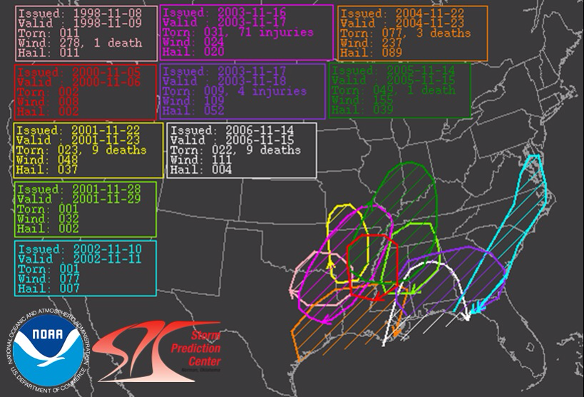
Prior to tomorrow, there have been 10 Day 2 Moderate risk areas issued by the Storm Prediction Center. This is the farthest north.

Image
0 likes   

EF-5bigj
Category 3
Category 3
Posts: 864
Joined: Tue Feb 07, 2012 10:36 pm
Location: Spartanburg,SC

#18 Postby EF-5bigj » Sat Nov 16, 2013 1:42 pm

This will be interesting to watch unfold I hope everyone in the path stays safe.
0 likes   

WeatherGuesser
Category 5
Category 5
Posts: 2672
Joined: Tue Jun 29, 2010 6:46 am

#19 Postby WeatherGuesser » Sat Nov 16, 2013 2:16 pm

Look at the dates in that chart for the '03, '05 and '06 events, 11-14, 15, 16, 17 and 18 are repeated and this year falls right into it.
0 likes   

User avatar
Cyclenall
Category 5
Category 5
Posts: 6628
Joined: Thu Jun 08, 2006 10:01 pm
Location: Ontario, Canada

Re: Re:

#20 Postby Cyclenall » Sat Nov 16, 2013 2:36 pm

CrazyC83 wrote:
Cyclenall wrote:I almost missed this. I'm in the 30% severe probability too :eek: . I don't remember that happening much anytime. The forecast is "thunder-showers" but I often find that no matter what :roll: .


You're almost in the Moderate Risk...especially rare in November. And I am in the Slight Risk even though there is no mention of thunder right now...

Cool, but I'm extremely skeptical anything of interest will occur IMBY. Usually these big things happen when you least suspect it so I'll keep an eye on it anyways.

WeatherGuesser wrote:
CrazyC83 wrote:You're almost in the Moderate Risk...especially rare in November.

But not unheard of. I don't know the count of Moderates, but I see at least 4 Highs with some serious outbreaks:

http://en.wikipedia.org/wiki/List_of_SPC_high-risk_days

November has somewhat of a reputation:

http://www.crh.noaa.gov/news/display_cm ... 0&source=0

Crazy is talking about MOD risks in Canada in the month of November.
0 likes   


Return to “USA & Caribbean Weather”

Who is online

Users browsing this forum: No registered users and 49 guests