
Potential Severe Event - October 12/13+
Moderator: S2k Moderators
Forum rules

The posts in this forum are NOT official forecast and should not be used as such. They are just the opinion of the poster and may or may not be backed by sound meteorological data. They are NOT endorsed by any professional institution or STORM2K.
Potential Severe Event - October 12/13+
Pretty decent looking set-up. SPC mentioned it but didn't highlight an area. Probably will tomorrow.
0 likes
-
WeatherGuesser
- Category 5

- Posts: 2672
- Joined: Tue Jun 29, 2010 6:46 am
ZCZC SPCSWOD48 ALL
ACUS48 KWNS 090853
SPC AC 090853
DAY 4-8 CONVECTIVE OUTLOOK
NWS STORM PREDICTION CENTER NORMAN OK
0353 AM CDT TUE OCT 09 2012
VALID 121200Z - 171200Z
...DISCUSSION...
MEDIUM RANGE MODELS CONTINUE TO INDICATE THAT A REMNANT CLOSED
LOW...OVER THE SOUTHERN GREAT BASIN AT THE START OF THIS PERIOD...
WILL FINALLY ACCELERATE MORE RAPIDLY NORTHEASTWARD...ACROSS THE
CENTRAL ROCKIES AND PLAINS BY LATE SATURDAY...BEFORE DE-AMPLIFYING
OVER THE GREAT LAKES REGION. AND CONFIDENCE IS INCREASING THAT THIS
WILL BE ACCOMPANIED BY SIGNIFICANT LEE SURFACE CYCLOGENESIS
...INCLUDING A SUB-1000 MB SURFACE LOW CENTER. ALTHOUGH QUESTIONS
LINGER CONCERNING THE POTENTIAL MAGNITUDE OF DESTABILIZATION...
INSTABILITY...DEEP LAYER FLOW FIELDS/VERTICAL SHEAR AND FORCING FOR
UPWARD VERTICAL MOTION STILL APPEAR MOST SUPPORTIVE OF SEVERE
WEATHER POTENTIAL IN THE WARM SECTOR OF THIS SYSTEM ON SATURDAY.
THIS SEEMS MOST PROBABLE FROM PARTS OF EASTERN NEBRASKA AND KANSAS
NORTHEASTWARD ACROSS NORTHERN MISSOURI...IOWA...AND PARTS OF
SOUTHERN MINNESOTA...SOUTHWESTERN WISCONSIN...AND NORTHWESTERN
ILLINOIS. GIVEN THE SEVERE WIND AND TORNADO POTENTIAL POSSIBLE
WITHIN A KINEMATIC ENVIRONMENT NEAR A 70-90 KT SOUTHWESTERLY 500 MB
JET...AND 50-70 KT SOUTHERLY 850 MB JET...A REGIONAL SEVERE OUTLOOK
APPEARS WARRANTED...AS THE POTENTIAL EVENT BEGINS TO COME WITHIN A
MORE PREDICTABLE TIME FRAME.
..KERR.. 10/09/2012
0 likes

Re: Potential Severe Event - October 12/13+
Reed Timmer and his elk are calling this a "potentially major tornado outbreak on Friday-Saturday across the central U.S." It goes on; "Based on the current forecast models, Friday and Saturday will likely be the most significant tornado outbreak of the year, with impacts more widespread than even the April 14, 2002 outbreak." I question this, how bad does everyone here really think this can get? I'm very skeptical on those words. I like Reed and his words but the same was said eariler this year and only a few tornadoes formed. Crazy, are you going crazy over this one yet? 
A bit off-topic, but was the Tuscaloosa EF4 from April 27, 2011 upgraded to an EF5 recently? TwisterChasers.com had an email that stated it was an EF5. That's what I thought right from the get-go so I hope it was.
A bit off-topic, but was the Tuscaloosa EF4 from April 27, 2011 upgraded to an EF5 recently? TwisterChasers.com had an email that stated it was an EF5. That's what I thought right from the get-go so I hope it was.
0 likes
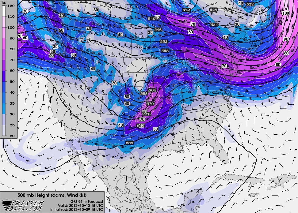
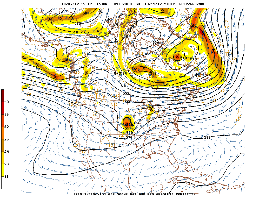
Looks pretty good at 500mb
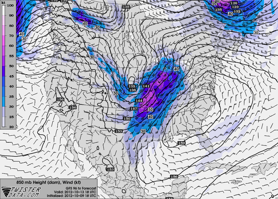
Nice 850mb jet coming up through Missouri and Iowa.
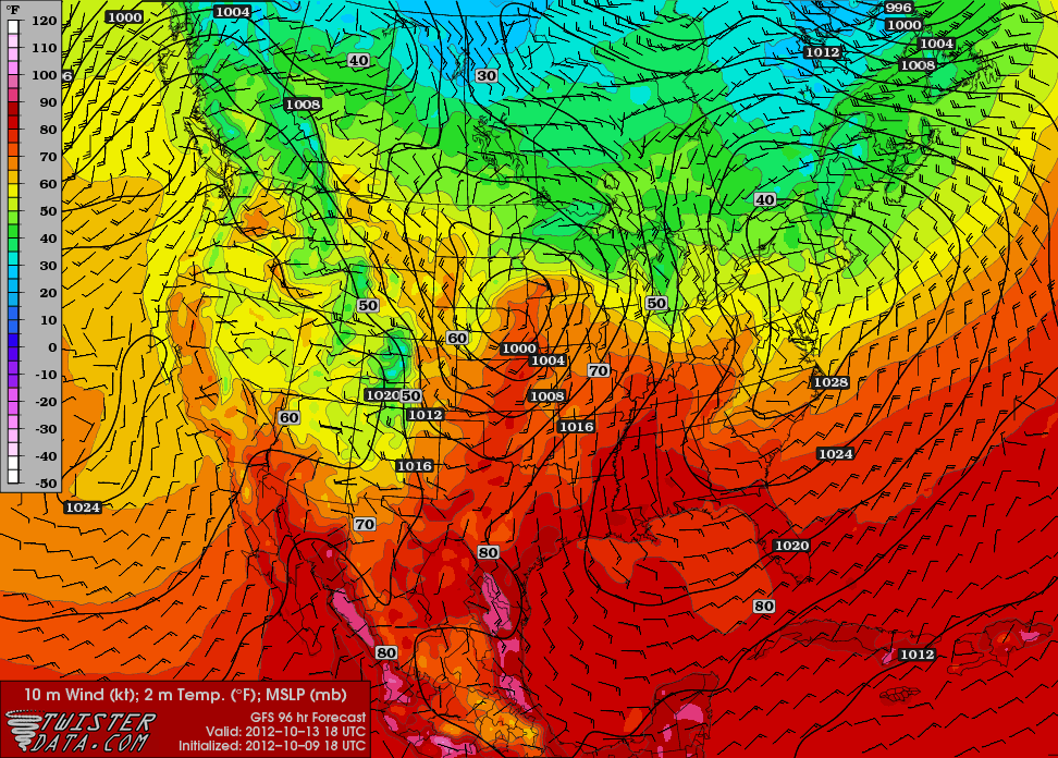
Pretty good but not super high moisture (duh its October).
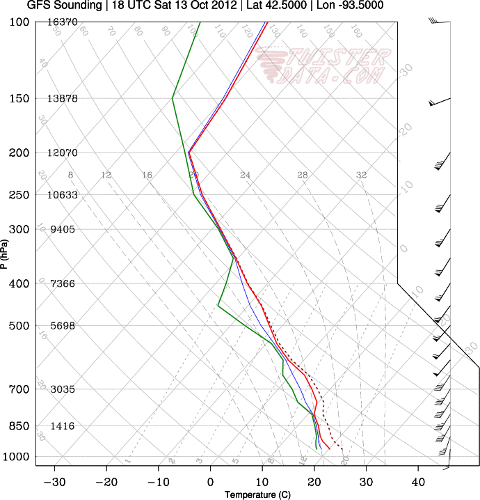
Model sounding for near Des Moines.
It certainly looks favorable for severe weather. Just not convinced of a major tornado event. Directional shear seems iffy. I do think we get a 15% MDT day out of it though .
0 likes
Interesting little paragraph from the Twin Cities AFD.
AS PREVIOUSLY STATED IN AN AFD ON MONDAY AFTN...THIS PATTERN IS
SIMILAR TO AN EVENT THAT HAPPENED IN LATE OCTOBER 1996. THE CIPS
STILL HAS THE SAME SCENARIO. THE OVERALL PRECIPITATION FIELD BY
THE END OF THE EVENT IS VERY CONDUCIVE TO TWO TYPES OF SYNOPTIC
SCALE FORCING REGIMES WHICH PLACES TWO AREAS OF HEAVY
PRECIPITATION. ONE IS ACROSS WC MN...NE TO NC MN. THE OTHER HIGHER
BANDS OF RAINFALL OCCURRED IN SOUTHERN IOWA...AND INTO SOUTHERN
WI. BASED ON HOW THESE STORMS SYSTEM EVOLVE...IT LOOKS AS THOUGH
THE SOUTHERN IOWA HEAVIER PRECIPITATION AREA IS ASSOCIATED WITH
CONVECTION ALONG AND NEAR THE SFC LOW. THE OTHER IS ASSOCIATED
WITH THE DEFORMATION ZONE. THEREFORE...THIS FORECAST IS HIGHLY
BASED ON WHEN AND WHERE THESE TWO REGIMES DEVELOP AND EVOLVE OVER
THE WEEKEND.
Obviously the rain is needed everywhere in IA/WI/MN so this won't be a problem.
0 likes
-
WeatherGuesser
- Category 5
- Posts: 2672
- Joined: Tue Jun 29, 2010 6:46 am


I think it's a far stretch to call it the most significant outbreak of the year  . You need a roaring jet and strong open vorticity at the 5h level similar to the March event for that kind of outbreak. This is a strong compact cutoff conducive to linear storm formation. Locally at the southern end of this thing and near the low we could get some slight risk areas with a few tornadoes. But then again what do I know . SPC does a great job with these things.
0 likes
The above post and any post by Ntxw is NOT an official forecast and should not be used as such. It is just the opinion of the poster and may or may not be backed by sound meteorological data. It is NOT endorsed by any professional institution including Storm2k. For official information, please refer to NWS products.
Help support Storm2K!
-
BlueIce
- S2K Supporter

- Posts: 194
- Age: 37
- Joined: Mon Sep 01, 2008 10:05 pm
- Location: Oklahoma City, Oklahoma
Re: Potential Severe Event - October 12/13+
The SPC is now adding a 30% for Central Oklahoma. It looks like a tough forecast based on their latest discussion.
...THE CENTRAL CONUS...
A COMPLEX SCENARIO CONTINUES TO EVOLVE FOR THE DAY 2 PERIOD...WITH
SOME MODEL DISAGREEMENT ON SYNOPTIC-SCALE SYSTEM PROGRESSION --
PARTICULARLY ACROSS THE CENTRAL AND SRN PLAINS -- COMBINING WITH
QUESTIONS REGARDING BOUNDARY LAYER EVOLUTION TO RESULT IN FAIRLY
SUBSTANTIAL UNCERTAINTY REGARDING BOTH LOCATION AND DEGREE OF SEVERE
POTENTIAL.
CONVECTION WILL LIKELY BE ONGOING FROM PARTS OF W TX NEWD ACROSS THE
CENTRAL PLAINS INTO THE UPPER MIDWEST/UPPER MS VALLEY REGION EARLY.
THIS PRECIPITATION/CLOUD COVER -- PARTICULARLY FROM THE MID MO
VALLEY REGION NEWD -- MAY HINDER APPRECIABLE AIRMASS DESTABILIZATION
THROUGH THE AFTERNOON. THUS -- DESPITE A FAVORABLE KINEMATIC
ENVIRONMENT...DEGREE OF SURFACE-BASED SEVERE RISK REMAINS IN
QUESTION...SUPPORTING A SWWD SHIFT IN SEVERE WEATHER PROBABILITY
THIS FORECAST.
WHILE ONGOING CLOUDS/PRECIPITATION WILL LIKELY AFFECT MORE SRN
PORTIONS OF THE RISK AREA AS WELL...HINTS OF POTENTIAL FOR SOME
DESTABILIZATION BEHIND AN INITIAL BAND OF CONVECTION ARE EVIDENT --
PARTICULARLY GIVEN THE HIGHER THETA-E BOUNDARY LAYER EXPECTED IN
THIS AREA. GIVEN THIS POTENTIAL...AND A BACKGROUND WIND FIELD
SUPPORTIVE OF ORGANIZED/SUPERCELL STORMS...AN AFTERNOON/EVENING
INCREASE IN SEVERE THREAT FROM NWRN MO/ERN KS SWWD INTO WRN N TX
REMAINS POSSIBLE. WHILE DETAILS REGARDING POTENTIAL STORM MODE
ACROSS THIS REGION ARE UNCERTAIN...THREAT FOR HAIL AND DAMAGING
WINDS ALONG WITH ISOLATED TORNADOES EXISTS.
0 likes
-
BlueIce
- S2K Supporter
- Posts: 194
- Age: 37
- Joined: Mon Sep 01, 2008 10:05 pm
- Location: Oklahoma City, Oklahoma
Re: Potential Severe Event - October 12/13+
Good chance of super cell activity today in Oklahoma!
URGENT - IMMEDIATE BROADCAST REQUESTED
TORNADO WATCH NUMBER 661
NWS STORM PREDICTION CENTER NORMAN OK
100 PM CDT SAT OCT 13 2012
THE NWS STORM PREDICTION CENTER HAS ISSUED A
TORNADO WATCH FOR PORTIONS OF
WESTERN AND CENTRAL OKLAHOMA
NORTHWEST TEXAS
EFFECTIVE THIS SATURDAY AFTERNOON AND EVENING FROM 100 PM UNTIL
900 PM CDT.
TORNADOES...HAIL TO 2 INCHES IN DIAMETER...THUNDERSTORM WIND
GUSTS TO 70 MPH...AND DANGEROUS LIGHTNING ARE POSSIBLE IN THESE
AREAS.
THE TORNADO WATCH AREA IS APPROXIMATELY ALONG AND 65 STATUTE
MILES EAST AND WEST OF A LINE FROM 45 MILES EAST NORTHEAST OF
ALVA OKLAHOMA TO 20 MILES SOUTH SOUTHWEST OF ABILENE TEXAS. FOR
A COMPLETE DEPICTION OF THE WATCH SEE THE ASSOCIATED WATCH
OUTLINE UPDATE (WOUS64 KWNS WOU1).
REMEMBER...A TORNADO WATCH MEANS CONDITIONS ARE FAVORABLE FOR
TORNADOES AND SEVERE THUNDERSTORMS IN AND CLOSE TO THE WATCH
AREA. PERSONS IN THESE AREAS SHOULD BE ON THE LOOKOUT FOR
THREATENING WEATHER CONDITIONS AND LISTEN FOR LATER STATEMENTS
AND POSSIBLE WARNINGS.
DISCUSSION...THUNDERSTORM DEVELOPMENT IS LIKELY IN THE NEXT COUPLE
OF HOURS FROM NW TX INTO WRN OK...ALONG AND JUST E OF THE SURFACE
COLD FRONT. A NARROW ZONE OF SURFACE HEATING TO THE W OF THE
ONGOING CONVECTION FROM N TX INTO CENTRAL OK...AND BOUNDARY LAYER
DEWPOINTS IN THE UPPER 60S...ARE SUPPORTING MLCAPE NEAR 2000 J/KG.
DEEP-LAYER AND LOW-LEVEL VERTICAL SHEAR ARE FAVORABLE FOR
SUPERCELLS...AND THE CONVECTIVE MODE SHOULD BE A MIX OF
SEMI-DISCRETE CELLS AND LINE SEGMENTS THROUGH THE AFTERNOON. A FEW
TORNADOES WILL BE POSSIBLE WITH THE MORE DISCRETE STORMS THROUGH THE
AFTERNOON/EVENING...ALONG WITH LARGE HAIL. DAMAGING WINDS WILL
BECOME MORE OF A THREAT LATER AS STORMS POTENTIALLY EVOLVE INTO A
MORE SOLID LINE CLOSER TO I-35 IN OK.
AVIATION...TORNADOES AND A FEW SEVERE THUNDERSTORMS WITH HAIL
SURFACE AND ALOFT TO 2 INCHES. EXTREME TURBULENCE AND SURFACE
WIND GUSTS TO 60 KNOTS. A FEW CUMULONIMBI WITH MAXIMUM TOPS TO
500. MEAN STORM MOTION VECTOR 24035.
0 likes
So, how did everyone like this "non-tornado" event? It fits right in with all this boring weather that has been plaguing the lands for a month and a half at least. There were 3 tornado reports and a few others the day before. This is what Reed Timmer had to say before this epic event:
- "potentially major tornado outbreak on Friday-Saturday across the central U.S." and "Based on the current forecast models, Friday and Saturday will likely be the most significant tornado outbreak of the year, with impacts more widespread than even the April 14, 2002 ( ) outbreak."
- (not exact quote (four days ago)) "Saturday could be a historic tornado event for Iowa!"
 I like Reed but this is just plain embarrassing. This isn't the first time this year that has happened either...putting "possible" before stating it doesn't smooth it over for me. I was very skeptical on those words and there was a reason for that. I will remain skeptical until the weather decides to pull an enormous mind-blower on me once again like previously (Great March Heatwave).
- "potentially major tornado outbreak on Friday-Saturday across the central U.S." and "Based on the current forecast models, Friday and Saturday will likely be the most significant tornado outbreak of the year, with impacts more widespread than even the April 14, 2002 (
- (not exact quote (four days ago)) "Saturday could be a historic tornado event for Iowa!"
0 likes
Return to “USA & Caribbean Weather”
Who is online
Users browsing this forum: Greener and 107 guests