Texas Spring 2026
Moderator: S2k Moderators
Forum rules

The posts in this forum are NOT official forecast and should not be used as such. They are just the opinion of the poster and may or may not be backed by sound meteorological data. They are NOT endorsed by any professional institution or STORM2K.
-
Stratton23
- Category 5

- Posts: 3594
- Joined: Fri Jul 21, 2023 10:59 pm
- Location: Katy, Tx
Re: Texas Spring 2026
man that GFS run is something to watch for in may, beyond a wet weekend across the state with a slow moving boundary, the GFS has another system on this heels that slows down and brings even more widespread heavy rains, flooding potential on creeks/ rivers may start to increase ( grounds are saturated in a lot of places and will only increase in saturation after this weekends system ) as its looking extremely active at least through the first 10-14 days of may
1 likes
-
wxman22

- Category 5
- Posts: 2060
- Joined: Mon Jan 30, 2006 12:39 am
- Location: Wichita Falls, TX
- Contact:
Re: Texas Spring 2026
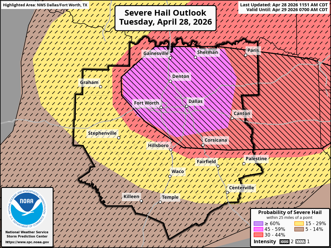
Moderate risk issued in DFW today for Hail.
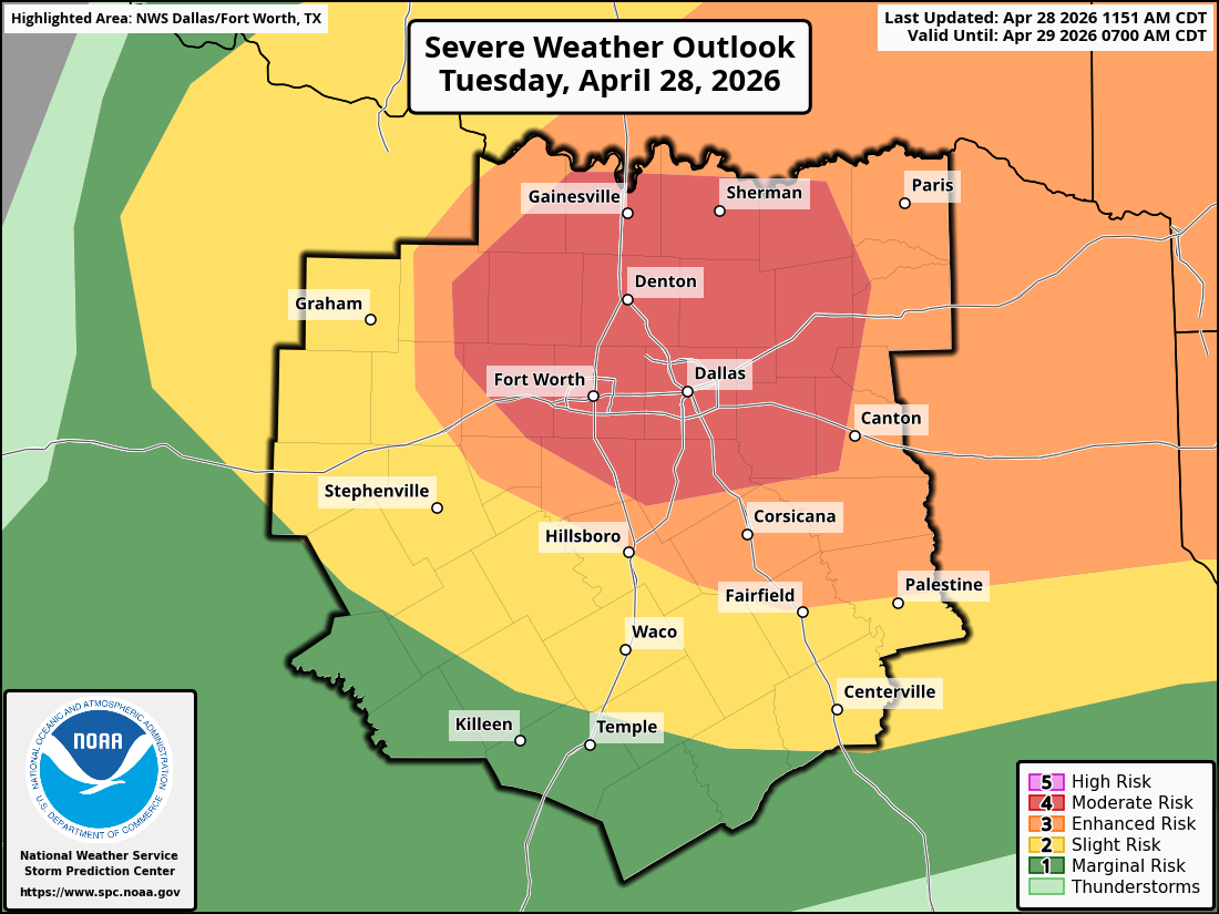
Day 1 Convective Outlook
NWS Storm Prediction Center Norman OK
1151 AM CDT Tue Apr 28 2026
Valid 281630Z - 291200Z
...THERE IS A MODERATE RISK OF SEVERE THUNDERSTORMS ACROSS NORTH
TEXAS...
...SUMMARY...
Multiple rounds of severe thunderstorms will occur across parts of
the southern Plains into the lower Mississippi/Tennessee Valleys and
Southeast through this evening. Very large to giant hail (2-4+
inches), swaths of severe/damaging winds, and a few tornadoes are
all possible.
...Southern Plains to Lower Mississippi Valley/Southeast...
Have upgraded portions of North Texas to a Moderate Risk for what is
anticipated to be a semi-focused sub-regional corridor of supercells
including very large hail potential along with some damaging
wind/tornado risk centered on mid-afternoon through
early/mid-evening.
First, a loosely organized complex of storms continues to progress
east-northeastward along the Red River of southeast
Oklahoma/northeast Texas and broader parts of eastern Oklahoma at
late morning. Additional increasingly surface-based development
seems probable on this near-frontal zone and associated moist axis
and thermal gradient that extends east-northeastward to the
Mid-South/ArkLaMiss. This may include supercells as well as the
possibility of an upscale-growing complex. Other initially elevated
severe storms are expected to continue and increase today from
northeast Oklahoma across the Ozarks toward parts of the
Mid-South/Mississippi Valley. Large hail is the initial risk, but a
surface-based storm risk could develop pending boundary layer
warming.
Broadly speaking outside on ongoing storms, a strongly unstable
airmass exists across the southern Plains to the ArkLaTex, along and
near a slowly retreating/northward-returning warm front. This is
beneath relatively strong winds aloft, particularly in
mid/high-levels based on morning upper-air data. Additional intense
surface-based convective development is forecast near the triple
point in north-central Texas towards the ArkLaTex this afternoon,
where extreme instability (4000+ J/kg MLCAPE) and very strong
deep-layer shear (50-60+ kt) will support the potential for multiple
intense supercells. Very large to giant hail (2-4+ inches) may occur
with the strongest supercells given the overall very favorable
environment and presence of steep mid-level lapse rates. Some
tornado threat may also exist with these supercells, even though
low-level shear is not forecast to be overly strong.
0 likes
-
rwfromkansas
- Category 5
- Posts: 3074
- Joined: Sat Aug 27, 2005 12:47 am
- Location: North Fort Worth
-
TomballEd
- Category 5
- Posts: 1339
- Age: 62
- Joined: Wed Aug 16, 2023 4:52 pm
- Location: Spring/Klein area, not Tomball
Re: Texas Spring 2026
Stratton23 wrote:man that GFS run is something to watch for in may, beyond a wet weekend across the state with a slow moving boundary, the GFS has another system on this heels that slows down and brings even more widespread heavy rains, flooding potential on creeks/ rivers may start to increase ( grounds are saturated in a lot of places and will only increase in saturation after this weekends system ) as its looking extremely active at least through the first 10-14 days of may
With the usual sharp drop off of rain for I-10 and points S. Hour 144 total GFS rainfall of 0.22 inches isn't very much. I'm glad its rained as much as it did two weeks ago. 6Z Euro shows a similar sharp cut off. East Texas will have flooding issues if the GFS is right.
0 likes
-
TomballEd
- Category 5
- Posts: 1339
- Age: 62
- Joined: Wed Aug 16, 2023 4:52 pm
- Location: Spring/Klein area, not Tomball
Re: Texas Spring 2026
DFW in a Moderate Risk, mainly for tennis ball to softball sized hail.
0 likes
-
txtwister78

- Category 5
- Posts: 2278
- Joined: Wed Jan 30, 2019 12:56 pm
- Location: San Antonio
Re: Texas Spring 2026
I think Euro continues to be the most consistent with the heavier rain threat further south Thursday into Friday which makes sense given the muscle behind this frontal boundary.
1 likes


Re: Texas Spring 2026
Today is definitely one of the most ominous setups I've seen for DFW proper in a long time.
Everything's semeingly coming together perfectly for a true (daytime) outbreak, and while the low level wind field could be better, I still tend to think the tornado threat is being a bit understated as is...
Everything's semeingly coming together perfectly for a true (daytime) outbreak, and while the low level wind field could be better, I still tend to think the tornado threat is being a bit understated as is...
0 likes


Re: Texas Spring 2026
Hopefully multiple storms can line up a bit and reduce some of the severe threats (linear) but definitely where they pop up and are separated more would be giant hailers.
0 likes
The above post and any post by Ntxw is NOT an official forecast and should not be used as such. It is just the opinion of the poster and may or may not be backed by sound meteorological data. It is NOT endorsed by any professional institution including Storm2k. For official information, please refer to NWS products.
Help support Storm2K!
-
HockeyTx82
- S2K Supporter

- Posts: 2829
- Joined: Tue Oct 27, 2009 11:17 am
- Location: Ponder, TX
Re: Texas Spring 2026
Yeah I'm not liking my chances here in Denton County today. I know it's highly conditional that you have to get under one of these, but my gosh what the odds begin as high as they are.
I already told my wife when she gets home from school to just stay home get the kids to get off the bus and just don't go anywhere and be prepared to take shelter and stay away from the windows.
I already told my wife when she gets home from school to just stay home get the kids to get off the bus and just don't go anywhere and be prepared to take shelter and stay away from the windows.
0 likes
Don't hold me accountable for anything I post on this forum. Leave the real forecasting up to the professionals.
Location: Ponder, TX (all observation posts are this location unless otherwise noted)
Location: Ponder, TX (all observation posts are this location unless otherwise noted)
Re: Texas Spring 2026
Ntxw wrote:Hopefully multiple storms can line up a bit and reduce some of the severe threats (linear) but definitely where they pop up and are separated more would be giant hailers.
A couple things I'm looking at is the unseasonably high dewpoints at the surface that are keeping the LCLs low, and at the same time, there's no large scale forcing mechanism to force the organization of a MCS / QLCS (it would be largely reliant on the development of a cold pool aloft). The trigger for storms is essentially an outflow boundary (which is causing erratic wind shifts at the surface) from this morning's activity. Both of those factors alone would lean towards the storms remaining discrete for an extended time and thus a more enhanced threat for rotating storms.
But it is true, there's no real LLJ at play to support long-lived / intense tornadoes, if they were to occur.
Last edited by snownado on Tue Apr 28, 2026 1:12 pm, edited 3 times in total.
0 likes
-
txtwister78
- Category 5
- Posts: 2278
- Joined: Wed Jan 30, 2019 12:56 pm
- Location: San Antonio
Re: Texas Spring 2026
0 likes
-
HockeyTx82
- S2K Supporter
- Posts: 2829
- Joined: Tue Oct 27, 2009 11:17 am
- Location: Ponder, TX
Re: Texas Spring 2026
And it just got issued
0 likes
Don't hold me accountable for anything I post on this forum. Leave the real forecasting up to the professionals.
Location: Ponder, TX (all observation posts are this location unless otherwise noted)
Location: Ponder, TX (all observation posts are this location unless otherwise noted)
-
txtwister78
- Category 5
- Posts: 2278
- Joined: Wed Jan 30, 2019 12:56 pm
- Location: San Antonio
-
rwfromkansas
- Category 5
- Posts: 3074
- Joined: Sat Aug 27, 2005 12:47 am
- Location: North Fort Worth
-
rwfromkansas
- Category 5
- Posts: 3074
- Joined: Sat Aug 27, 2005 12:47 am
- Location: North Fort Worth
Re: Texas Spring 2026
Quixotic wrote:Hail. Why’d it have to be hail?
Exactly. I love a good funnel cloud so long as it doesn't touch down, or seeing a good 60-70 mph severe storm. My roof can handle that. But, hail covers a bigger area.
1 likes
-
rwfromkansas
- Category 5
- Posts: 3074
- Joined: Sat Aug 27, 2005 12:47 am
- Location: North Fort Worth

Re: Texas Spring 2026
rwfromkansas wrote:Quixotic wrote:Hail. Why’d it have to be hail?
Exactly. I love a good funnel cloud so long as it doesn't touch down, or seeing a good 60-70 mph severe storm. My roof can handle that. But, hail covers a bigger area.
I replaced my roof in 22. Insurance is now 2% deductible as opposed to 1% in 22. That’s 10k. I’ve had three cars totaled by hail. I hate that clacking sound on my roof more than anything.
0 likes
Return to “USA & Caribbean Weather”
Who is online
Users browsing this forum: Brent, Greener, mmmmsnouts, opticsguy, rwfromkansas, txtwister78, wxman22 and 37 guests