Texas Spring 2026
Moderator: S2k Moderators
Forum rules

The posts in this forum are NOT official forecast and should not be used as such. They are just the opinion of the poster and may or may not be backed by sound meteorological data. They are NOT endorsed by any professional institution or STORM2K.

Re: Texas Spring 2026
Quarter size hail and some intense lightning in North Dallas near NorthPark center.
0 likes
-
CaptinCrunch

- S2K Supporter

- Posts: 8787
- Age: 58
- Joined: Mon Nov 03, 2003 4:33 pm
- Location: Kennedale, TX (Tarrant Co.)
Re: Texas Spring 2026
Storms are firing basically right over my house, no rain whatsoever but the air has cooled and you can hear thunder. Watching radar returns and it's raining about 2-3 miles east of me
0 likes

Re: Texas Spring 2026
Supercell near Rockwall warned for tennis ball sized hail. Same for the Commerce cell.
0 likes

Re: Texas Spring 2026
cstrunk wrote:Supercell near Rockwall warned for tennis ball sized hail. Same for the Commerce cell.
Oct 20, 2019 la Quinta hotel parking lot off I-30 just southwest of Rockwall was the only time I "saw" a tornado. Didn't actually see it until I looked at my phone camera video and saw it in the lightning flashes. It was a few miles northeast heading across the lake. We were driving east on the highway when our cell phones went nuts with tornado warning alerts. Screenshot below.

Last edited by Texoz on Mon Apr 27, 2026 9:47 pm, edited 2 times in total.
1 likes
Re: Texas Spring 2026
2 likes
-
Stratton23
- Category 5

- Posts: 3593
- Joined: Fri Jul 21, 2023 10:59 pm
- Location: Katy, Tx
Re: Texas Spring 2026
00z Euro is very wet and starting may 1–12th, its well below average temperatures as that front has staying power, no complaints at all!
0 likes
-
Brent
- S2K Supporter
- Posts: 38788
- Age: 37
- Joined: Sun May 16, 2004 10:30 pm
- Location: Tulsa Oklahoma
- Contact:
Re: Texas Spring 2026
I'm trying to tell people to enjoy this coming pattern because it's gonna be summer before you know it
Today may be the first of several days this week we stay in the 60s
Today may be the first of several days this week we stay in the 60s
0 likes
#neversummer
-
TomballEd
- Category 5
- Posts: 1337
- Age: 62
- Joined: Wed Aug 16, 2023 4:52 pm
- Location: Spring/Klein area, not Tomball
Re: Texas Spring 2026
I'm not expecting that much rain with the front. Cool weather for yard work will be nice. I mowed the lawn in a steam bath last weekend.
6Z Hi-Res NAM has a pretty decent cap which would be hard to break but if it does (Dallas County forecast sounding) late afternoon, over 4500 J/Kg MLCAPE, 50 knots deep shear and about 8*C/km lapse rates scream hail potential. SPC has DFW in CIG 2 hail. Mom, 2 sisters and a brother in law live in Bedford. (Tarrant County).

6Z Hi-Res NAM has a pretty decent cap which would be hard to break but if it does (Dallas County forecast sounding) late afternoon, over 4500 J/Kg MLCAPE, 50 knots deep shear and about 8*C/km lapse rates scream hail potential. SPC has DFW in CIG 2 hail. Mom, 2 sisters and a brother in law live in Bedford. (Tarrant County).
0 likes
-
wxman22

- Category 5
- Posts: 2057
- Joined: Mon Jan 30, 2006 12:39 am
- Location: Wichita Falls, TX
- Contact:
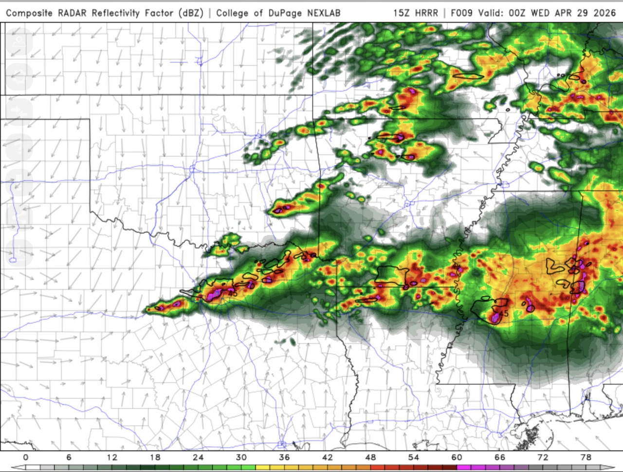
Re: Texas Spring 2026
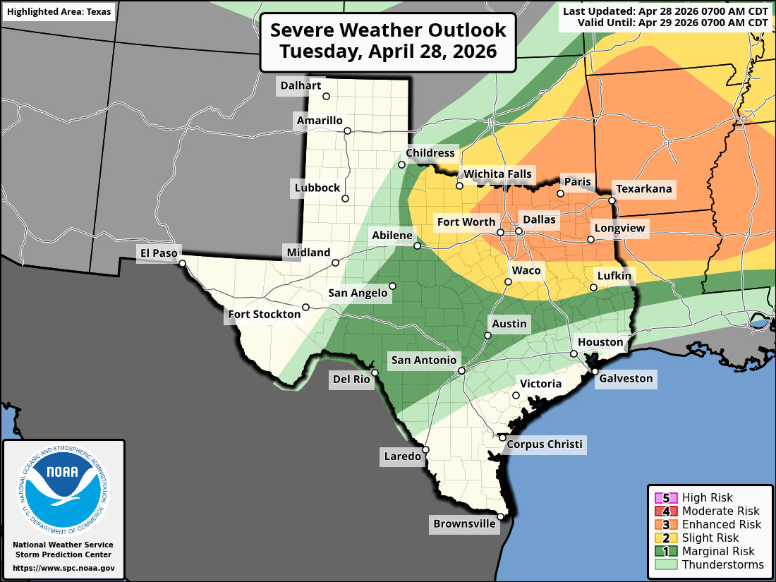
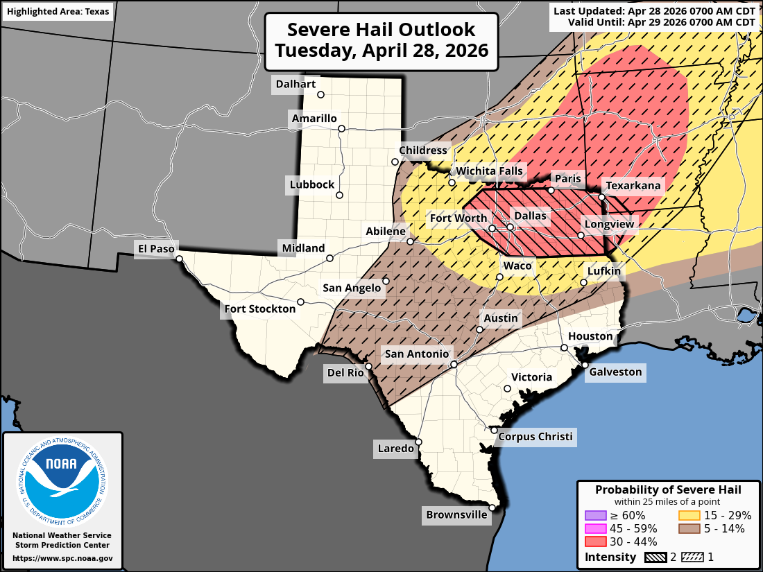
Day 1 Convective Outlook
NWS Storm Prediction Center Norman OK
0700 AM CDT Tue Apr 28 2026
Valid 281300Z - 291200Z
...THERE IS AN ENHANCED RISK OF SEVERE THUNDERSTORMS ACROSS PARTS OF
THE SOUTHERN PLAINS INTO THE LOWER MISSISSIPPI VALLEY AND
MID-SOUTH...
...SUMMARY...
Multiple rounds of severe thunderstorms will occur across parts of
the southern Plains into the lower Mississippi/Tennessee Valleys and
Southeast through this evening. Very large to giant hail (2-4+
inches), swaths of severe/damaging winds, and a few tornadoes are
all possible.
...Southern Plains into the Lower Mississippi Valley/Southeast...
With large-scale upper troughing anchored over the Plains and
central Canada, an embedded mid-level shortwave trough will eject
eastward across the southern/central Plains to the lower/mid MS
Valleys by this evening. Rich low-level moisture continues to spread
northward from TX into southern OK this morning in tandem with a
low-level jet, and this trend should continue downstream into the
lower MS Valley through the day as a warm front lifts northward to a
weak surface low across the Ozarks. Another surface low will remain
over northwest TX, with a dryline extending southwestward to the Big
Bend region.
A strongly unstable airmass exists across the southern Plains to the
ArkLaTex, along and near a slowly retreating/northward-returning
warm front. Elevated supercells are ongoing across western north TX.
This activity is being aided by lift and strong deep-layer shear
associated with the ejecting mid-level shortwave trough, and
low-level warm/moist advection. Current expectations are for these
supercells to continue posing a threat for mainly large to very
large hail through the rest of the morning as they spread
east-northeastward across north TX/southern OK. But, eventual
clustering and a greater damaging wind threat may materialize into
the afternoon as this convection crosses the front and accesses
greater instability across AR and the Ozarks.
Additional surface-based convective development is forecast near the
triple point in north-central TX towards the ArkLaTex this
afternoon, where extreme instability (4000+ J/kg MLCAPE) and very
strong deep-layer shear (50-60+ kt) will support the potential for
multiple intense supercells. Very large to giant hail (2-4+ inches)
may occur with the strongest supercells given the overall very
favorable environment and presence of steep mid-level lapse rates.
Some tornado threat may also exist with these supercells, even
though low-level shear is not forecast to be overly strong.
1 likes
-
wxman22
- Category 5
- Posts: 2057
- Joined: Mon Jan 30, 2006 12:39 am
- Location: Wichita Falls, TX
- Contact:
Re: Texas Spring 2026
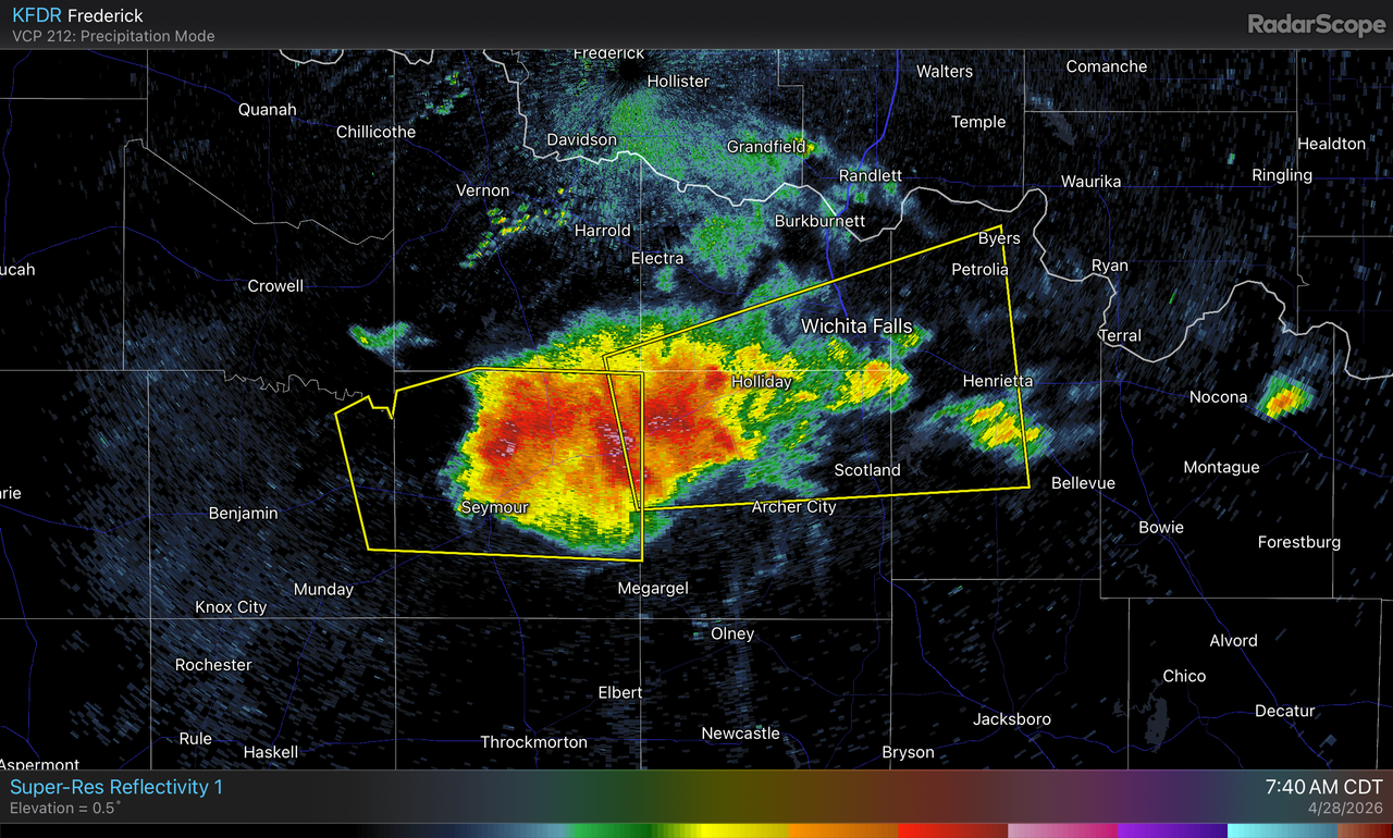
Was not expecting to wake up to a rouge supercell nearby this morning.
0 likes

Re: Texas Spring 2026
Stratton23 wrote:00z Euro is very wet and starting may 1–12th, its well below average temperatures as that front has staying power, no complaints at all!
At least we’ll have some cooler temps and lower humidity for a few days, but I’m not expecting much rain for areas in SETX S of I-10. I think maybe half an inch to an inch on average. It’s frustrating that the Coastal Plains keep missing out on the bigger totals. I’m curious to see what the drought monitor will look like on Thursday.
0 likes
Re: Texas Spring 2026
wxman22 wrote:Was not expecting to wake up to a rouge supercell nearby this morning.
https://i.postimg.cc/Dw0V3nJb/IMG-0813.png
I don't care what anyone else says, I think Wichita Falls has the most interesting weather in all of Texas. More winter weather than most (besides the panhandle) and more extremes (temperature, drought, severe weather, floods, you name it).
0 likes
-
cheezyWXguy

- Category 5
- Posts: 6285
- Joined: Mon Feb 13, 2006 12:29 am
- Location: Dallas, TX
Re: Texas Spring 2026
Interesting gust front trailing the supercell from its sw tip. I wonder if this will either serve as a focal point for development/rotation of later storms, dampen the environment, or neither.
0 likes
-
HockeyTx82
- S2K Supporter
- Posts: 2824
- Joined: Tue Oct 27, 2009 11:17 am
- Location: Ponder, TX
Re: Texas Spring 2026
Yeah well I'm not taking my chances I went ahead and parked under the garage at UNT because if those things hit around lunch time I don't want to be making a mad rush for it. I'll roll the dice for $20 and not have to get the car repaired after I just got it painted.
0 likes
Don't hold me accountable for anything I post on this forum. Leave the real forecasting up to the professionals.
Location: Ponder, TX (all observation posts are this location unless otherwise noted)
Location: Ponder, TX (all observation posts are this location unless otherwise noted)
-
rwfromkansas
- Category 5
- Posts: 3068
- Joined: Sat Aug 27, 2005 12:47 am
- Location: North Fort Worth
Re: Texas Spring 2026
Wish I had a garage at my school lol
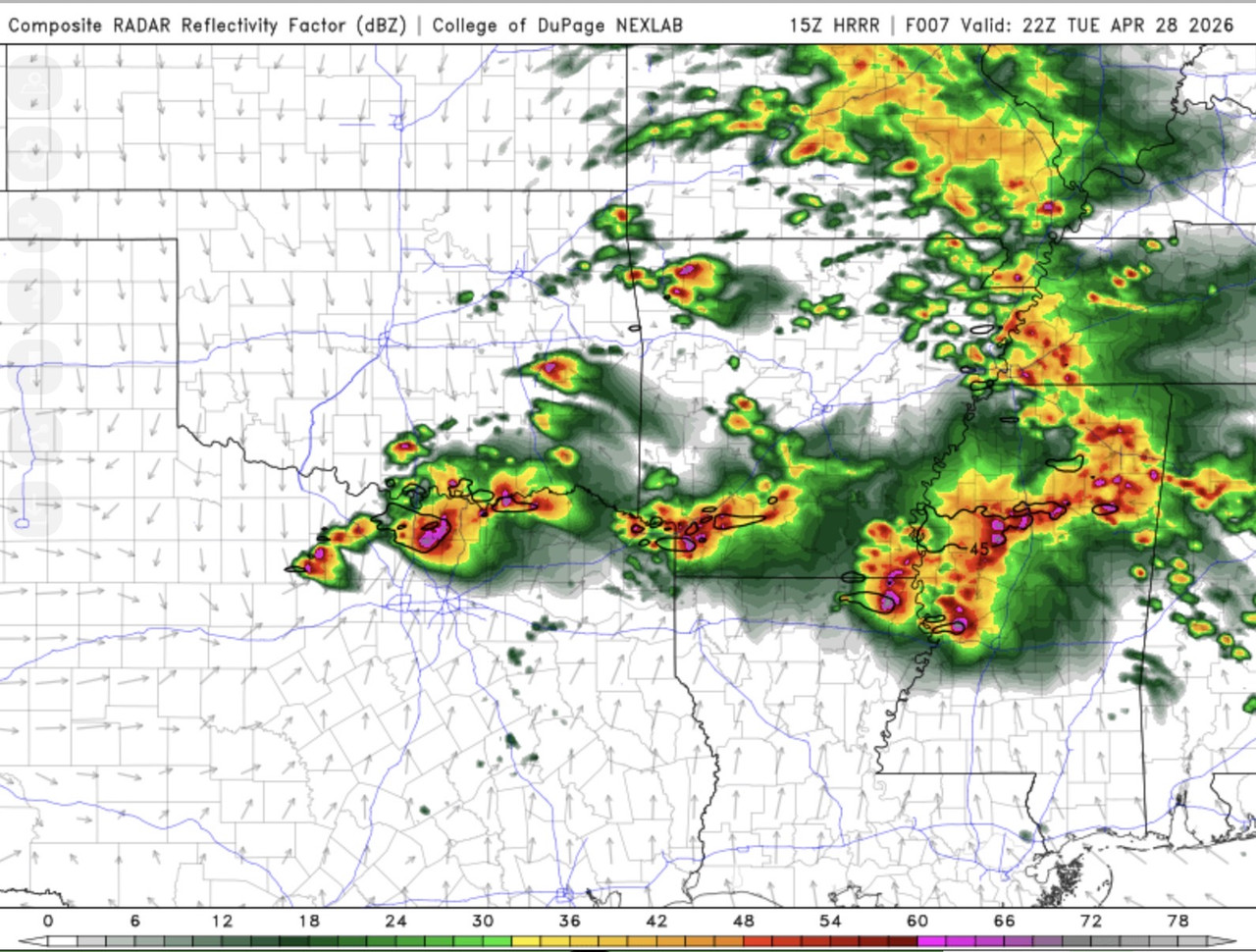
Getting a bit nervous as SPC moved back the enhanced risk west for hail and tornadoes across all of DFW today. It looks more linear, so I expect the tornado risk is pretty small really.
If it's after 5, I can be home. But, 4, I will be stuck at school with kids, so I hope it holds off...
Regarding the NAM, it basically has showed nothing many of the days with big storms happening.
I just wouldn't rely much upon that. It does show storms today, for what it's worth.
Last edited by rwfromkansas on Tue Apr 28, 2026 10:26 am, edited 1 time in total.
0 likes


-
wxman22
- Category 5
- Posts: 2057
- Joined: Mon Jan 30, 2006 12:39 am
- Location: Wichita Falls, TX
- Contact:
Re: Texas Spring 2026
Stay weather aware today in DFW and points east into the ArkLaTex. Supercells are going to probably be very intense today.
0 likes
-
txtwister78

- Category 5
- Posts: 2266
- Joined: Wed Jan 30, 2019 12:56 pm
- Location: San Antonio
Re: Texas Spring 2026
Mentioned it yesterday that today was more than likely DFW's day to be on guard.
Only aspect to consider or watch is whether storms from this morning have any impact in working over the atmosphere enough to effect timing or location of afternoon development.
Only aspect to consider or watch is whether storms from this morning have any impact in working over the atmosphere enough to effect timing or location of afternoon development.
0 likes
-
txtwister78
- Category 5
- Posts: 2266
- Joined: Wed Jan 30, 2019 12:56 pm
- Location: San Antonio
Re: Texas Spring 2026
Moderate risk added by SPC for the DFW metro (big hail threat upgrade)
0 likes
Return to “USA & Caribbean Weather”
Who is online
Users browsing this forum: 869MB, cheezyWXguy, rwfromkansas, Stratton23, Texas Snow, txtwister78, wxman22 and 50 guests