Texas Spring 2023

U.S. & Caribbean Weather Discussions and Severe Weather Events

Moderator: S2k Moderators

Forum rules

The posts in this forum are NOT official forecast and should not be used as such. They are just the opinion of the poster and may or may not be backed by sound meteorological data. They are NOT endorsed by any professional institution or STORM2K.

Help Support Storm2K
Message
Author
Brent
S2K Supporter
S2K Supporter
Posts: 38089
Age: 36
Joined: Sun May 16, 2004 10:30 pm
Location: Tulsa Oklahoma
Contact:

Re: Texas Spring 2023

#941 Postby Brent » Mon Apr 24, 2023 9:06 pm

Iceresistance wrote:
Cpv17 wrote:
rwfromkansas wrote:Only a slight risk tomorrow or Wednesday. I hope to see some storms again. Been boring.


It mostly appears to me that most of the rain will be in Oklahoma over the next 7 days per the WPC.

Yeah, I'm now expecting up to 6 inches of rain, lol.


I'll believe it when I see it here but yeah I'm like the bullseye :lol: apparently it's been Tulsa's driest April on record so far
1 likes   
#neversummer

User avatar
Iceresistance
Category 5
Category 5
Posts: 9288
Age: 21
Joined: Sat Oct 10, 2020 9:45 am
Location: Tecumseh, OK/Norman, OK

Re: Texas Spring 2023

#942 Postby Iceresistance » Tue Apr 25, 2023 6:23 am

The WPC QPF keeps going up in Oklahoma, someone is going to get dumped with 5+ inches of rain.
1 likes   
Bill 2015 & Beta 2020

Winter 2020-2021 :cold:

All observations are in Tecumseh, OK unless otherwise noted.

Winter posts are focused mainly for Oklahoma & Texas.

Take any of my forecasts with a grain of salt, refer to the NWS, SPC, and NHC for official information

Never say Never with weather! Because ANYTHING is possible!

User avatar
bubba hotep
S2K Supporter
S2K Supporter
Posts: 5837
Joined: Wed Dec 28, 2016 1:00 am
Location: Collin County Texas

Re: Texas Spring 2023

#943 Postby bubba hotep » Tue Apr 25, 2023 7:28 am

Day 2 getting dicey for DFW

Image
1 likes   
Winter time post are almost exclusively focused on the DFW area.

rwfromkansas
Category 5
Category 5
Posts: 2627
Joined: Sat Aug 27, 2005 12:47 am
Location: North Fort Worth

Re: Texas Spring 2023

#944 Postby rwfromkansas » Tue Apr 25, 2023 8:11 am

Saw graphics that the HRRR is all in on widespread severe for DFW tomorrow. I guess be careful what you wish for. We had to replace shingles in March during that 80 mph wind event.
2 likes   

User avatar
Cpv17
Category 5
Category 5
Posts: 4979
Joined: Wed Dec 07, 2016 2:24 pm
Location: Wharton/El Campo, TX

Re: Texas Spring 2023

#945 Postby Cpv17 » Tue Apr 25, 2023 8:18 am

rwfromkansas wrote:Saw graphics that the HRRR is all in on widespread severe for DFW tomorrow. I guess be careful what you wish for. We had to replace shingles in March during that 80 mph wind event.


Well it won’t be boring tomorrow for you lol
3 likes   

User avatar
cycloneye
Admin
Admin
Posts: 145308
Age: 68
Joined: Thu Oct 10, 2002 10:54 am
Location: San Juan, Puerto Rico

Re: Texas Spring 2023

#946 Postby cycloneye » Tue Apr 25, 2023 8:43 am

Image
3 likes   
Visit the Caribbean-Central America Weather Thread where you can find at first post web cams,radars
and observations from Caribbean basin members Click Here

User avatar
Iceresistance
Category 5
Category 5
Posts: 9288
Age: 21
Joined: Sat Oct 10, 2020 9:45 am
Location: Tecumseh, OK/Norman, OK

Re: Texas Spring 2023

#947 Postby Iceresistance » Tue Apr 25, 2023 9:12 am

It's not often to see a WPC map that features Oklahoma as the bullseye in the states, goodness gracious.

Image
https://s11.gifyu.com/images/p168i-2.gif
3 likes   
Bill 2015 & Beta 2020

Winter 2020-2021 :cold:

All observations are in Tecumseh, OK unless otherwise noted.

Winter posts are focused mainly for Oklahoma & Texas.

Take any of my forecasts with a grain of salt, refer to the NWS, SPC, and NHC for official information

Never say Never with weather! Because ANYTHING is possible!

User avatar
cheezyWXguy
Category 5
Category 5
Posts: 6108
Joined: Mon Feb 13, 2006 12:29 am
Location: Dallas, TX

Re: Texas Spring 2023

#948 Postby cheezyWXguy » Tue Apr 25, 2023 9:30 am

rwfromkansas wrote:Saw graphics that the HRRR is all in on widespread severe for DFW tomorrow. I guess be careful what you wish for. We had to replace shingles in March during that 80 mph wind event.

Agreed, and a similar event would be a lot worse this time of year than it was back then. More leaves on the trees now means more trees would go down
1 likes   

User avatar
Cpv17
Category 5
Category 5
Posts: 4979
Joined: Wed Dec 07, 2016 2:24 pm
Location: Wharton/El Campo, TX

Re: Texas Spring 2023

#949 Postby Cpv17 » Tue Apr 25, 2023 10:17 am

I just checked the 12z HRRR. I can indeed confirm that it looks pretty bad for you central and north Texas folk tomorrow. Yikes!
1 likes   

User avatar
ElectricStorm
Category 5
Category 5
Posts: 5044
Age: 24
Joined: Tue Aug 13, 2019 11:23 pm
Location: Skiatook, OK / Norman, OK

Re: Texas Spring 2023

#950 Postby ElectricStorm » Tue Apr 25, 2023 10:19 am

I wouldn't be surprised to see a 10 hatched tornado area at some point for tomorrow. Some of these model runs are nasty, hopefully we don't see anything destructive.
3 likes   
B.S Meteorology, University of Oklahoma '25

Please refer to the NHC, NWS, or SPC for official information.

WacoWx
Category 2
Category 2
Posts: 664
Joined: Mon Dec 28, 2009 4:14 pm
Location: NOT Waco, TX ----> Dallas, TX

Re: Texas Spring 2023

#951 Postby WacoWx » Tue Apr 25, 2023 12:54 pm

What is the timing for the Metroplex?
1 likes   

gpsnowman
S2K Supporter
S2K Supporter
Posts: 3185
Joined: Fri Jan 07, 2011 10:35 am
Location: Grand Prairie Tx

Re: Texas Spring 2023

#952 Postby gpsnowman » Tue Apr 25, 2023 1:58 pm

WacoWx wrote:What is the timing for the Metroplex?

Probably around 5ish or thereafter.
2 likes   

WacoWx
Category 2
Category 2
Posts: 664
Joined: Mon Dec 28, 2009 4:14 pm
Location: NOT Waco, TX ----> Dallas, TX

Re: Texas Spring 2023

#953 Postby WacoWx » Tue Apr 25, 2023 2:20 pm

TY
0 likes   

User avatar
EnnisTx
S2K Supporter
S2K Supporter
Posts: 896
Joined: Sat Dec 26, 2015 4:06 pm
Location: Albany, Texas
Contact:

Re: Texas Spring 2023

#954 Postby EnnisTx » Tue Apr 25, 2023 3:03 pm

ElectricStorm wrote:I wouldn't be surprised to see a 10 hatched tornado area at some point for tomorrow. Some of these model runs are nasty, hopefully we don't see anything destructive.


I totally agree, looking more and more like this will be a significant severe weather event in North Texas.
1 likes   

User avatar
txtwister78
Category 5
Category 5
Posts: 1854
Joined: Wed Jan 30, 2019 12:56 pm
Location: San Antonio

Re: Texas Spring 2023

#955 Postby txtwister78 » Tue Apr 25, 2023 3:23 pm

I think for the DFW metro timing is going to be a big factor along with the progression of the frontal boundary. It's also possible storms developing tonight over southern Oklahoma near the river move into the DFW region overnight and work over the atmosphere a bit reducing the overall severe weather threat during the day on Wednesday. Some models show this while others aren't quite sold on this scenario. As it is most models keep DFW highs around 70 tomorrow or lower in afternoon depending on the progress of the frontal boundary.  

18z HRRR has shifted a bit south overall toward the Waco region (warm sector) in terms of explosive supercell development Wednesday afternoon into early evening, but this could change in future runs. Overall, still a lot to watch and folks should definitely be weather aware across that entire region tomorrow. Threat looks to shift south into the HC and AUS/SA corridor overnight into Thursday morning but hopefully with the loss of daytime heating storms will be more manageable then.
4 likes   

cstrunk
Category 2
Category 2
Posts: 635
Joined: Sat Jul 04, 2020 10:38 am
Location: Longview, TX

Re: Texas Spring 2023

#956 Postby cstrunk » Tue Apr 25, 2023 3:30 pm

I'm really hoping my flight that is scheduled to arrive at 5:40 pm into Love Field makes it before storms do..
0 likes   

User avatar
bubba hotep
S2K Supporter
S2K Supporter
Posts: 5837
Joined: Wed Dec 28, 2016 1:00 am
Location: Collin County Texas

Re: Texas Spring 2023

#957 Postby bubba hotep » Tue Apr 25, 2023 3:42 pm

txtwister78 wrote:I think for the DFW metro timing is going to be a big factor along with the progression of the frontal boundary. It's also possible storms developing tonight over southern Oklahoma near the river move into the DFW region overnight and work over the atmosphere a bit reducing the overall severe weather threat during the day on Wednesday. Some models show this while others aren't quite sold on this scenario. As it is most models keep DFW highs around 70 tomorrow or lower in afternoon depending on the progress of the frontal boundary.  

18z HRRR has shifted a bit south overall toward the Waco region (warm sector) in terms of explosive supercell development Wednesday afternoon into early evening, but this could change in future runs. Overall, still a lot to watch and folks should definitely be weather aware across that entire region tomorrow. Threat looks to shift south into the HC and AUS/SA corridor overnight into Thursday morning but hopefully with the loss of daytime heating storms will be more manageable then.


Yea, was going to post that; there is a pretty big southward shift on the HRRR with the overnight storms with them tracking more SE vs E and staying below the Red River. This probably works over the atmosphere and, depending on organization, an MCS would leave some subsidence in its wake.
3 likes   
Winter time post are almost exclusively focused on the DFW area.

rwfromkansas
Category 5
Category 5
Posts: 2627
Joined: Sat Aug 27, 2005 12:47 am
Location: North Fort Worth

Re: Texas Spring 2023

#958 Postby rwfromkansas » Tue Apr 25, 2023 4:13 pm

There often is a last-minute shift, so will see how things evolve.
3 likes   

User avatar
Ntxw
Storm2k Moderator
Storm2k Moderator
Posts: 22785
Joined: Wed Oct 21, 2009 6:34 pm
Location: DFW, Texas

Re: Texas Spring 2023

#959 Postby Ntxw » Tue Apr 25, 2023 4:20 pm

Models indicate dewpoint recovery to mid-60s tomorrow north of interstate 20. South of I-20 in the 70s where the best fuel and forcing may be.

Most should see at least 0.75-1 inch of rain.
5 likes   
The above post and any post by Ntxw is NOT an official forecast and should not be used as such. It is just the opinion of the poster and may or may not be backed by sound meteorological data. It is NOT endorsed by any professional institution including Storm2k. For official information, please refer to NWS products.

  Help support Storm2K!
Help Support Storm2K

User avatar
somethingfunny
ChatStaff
ChatStaff
Posts: 3926
Age: 37
Joined: Thu May 31, 2007 10:30 pm
Location: McKinney, Texas

Re: Texas Spring 2023

#960 Postby somethingfunny » Tue Apr 25, 2023 5:56 pm

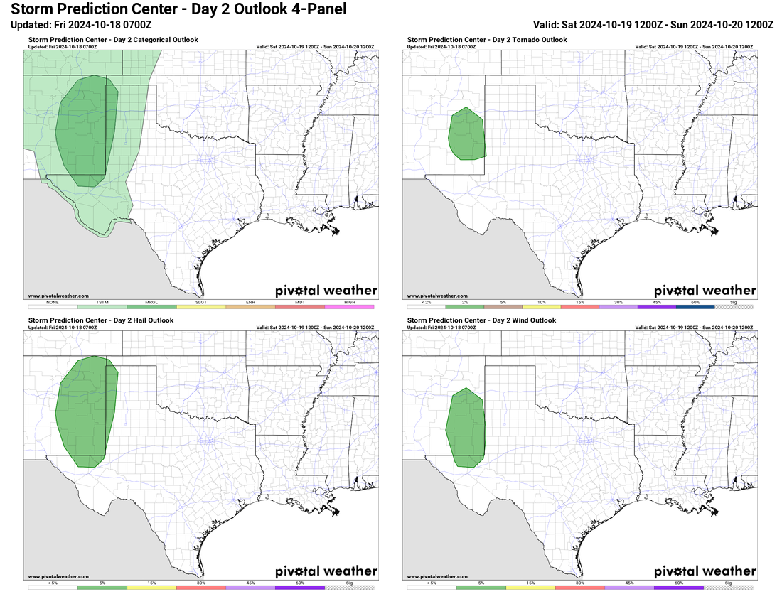
I am always reminded of the April 3 2012 event, when mesoscale outflow boundaries from overnight storms passing and collapsing nearby set the stage for rotating supercell development to focus along those residual boundaries.

We'll need to watch the wind shifts at various atmospheric levels closely tomorrow, along with any localized variations in cloud cover affecting CAPE. I'm sure some areas will underperform.due to subsidence, while other areas nearby could overperform if the boundaries can align.

It bears watching, but I'm often of the "wake me up when the sun comes out" school of storm preparation.

txtwister78 wrote:I think for the DFW metro timing is going to be a big factor along with the progression of the frontal boundary. It's also possible storms developing tonight over southern Oklahoma near the river move into the DFW region overnight and work over the atmosphere a bit reducing the overall severe weather threat during the day on Wednesday. Some models show this while others aren't quite sold on this scenario. As it is most models keep DFW highs around 70 tomorrow or lower in afternoon depending on the progress of the frontal boundary.  

18z HRRR has shifted a bit south overall toward the Waco region (warm sector) in terms of explosive supercell development Wednesday afternoon into early evening, but this could change in future runs. Overall, still a lot to watch and folks should definitely be weather aware across that entire region tomorrow. Threat looks to shift south into the HC and AUS/SA corridor overnight into Thursday morning but hopefully with the loss of daytime heating storms will be more manageable then.
3 likes   
I am not a meteorologist, and any posts made by me are not official forecasts or to be interpreted as being intelligent. These posts are just my opinions and are probably silly opinions.


Return to “USA & Caribbean Weather”

Who is online

Users browsing this forum: No registered users and 13 guests