That was one of the craziest storms I've ever seen approaching DFW last night. Fortunately it weakened before the major population centers but yikes
I also tried numerous times to login last night and it never worked either
Tornado watch again today here but it's looking like we get a pretty solid cold front next week. Way below normal temps showing up
Texas Spring 2026
Moderator: S2k Moderators
Forum rules

The posts in this forum are NOT official forecast and should not be used as such. They are just the opinion of the poster and may or may not be backed by sound meteorological data. They are NOT endorsed by any professional institution or STORM2K.
-
Brent
- S2K Supporter

- Posts: 38786
- Age: 37
- Joined: Sun May 16, 2004 10:30 pm
- Location: Tulsa Oklahoma
- Contact:
Re: Texas Spring 2026
Last edited by Brent on Sun Apr 26, 2026 5:26 pm, edited 2 times in total.
0 likes
#neversummer
-
wxman22

- Category 5

- Posts: 2051
- Joined: Mon Jan 30, 2006 12:39 am
- Location: Wichita Falls, TX
- Contact:
Re: Texas Spring 2026
Here we go again.
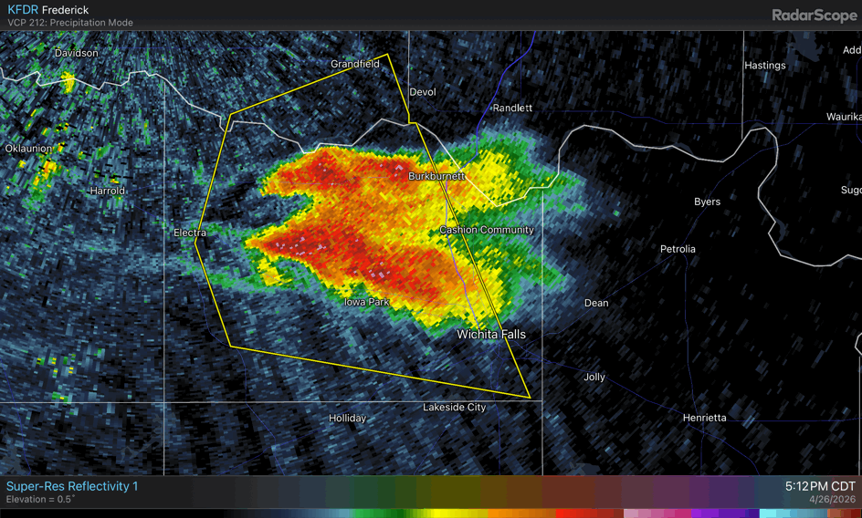
BULLETIN - IMMEDIATE BROADCAST REQUESTED
Severe Thunderstorm Warning
National Weather Service Norman OK
524 PM CDT Sun Apr 26 2026
The National Weather Service in Norman has issued a
* Severe Thunderstorm Warning for...
South central Comanche County in southwestern Oklahoma...
Cotton County in southwestern Oklahoma...
Southeastern Tillman County in southwestern Oklahoma...
Northeastern Wichita County in northern Texas...
* Until 615 PM CDT.
* At 524 PM CDT, a severe thunderstorm was located near Devol, moving
northeast at 30 mph.
HAZARD...Ping pong ball size hail and 60 mph wind gusts.
SOURCE...Radar indicated.
IMPACT...People and animals outdoors will be injured. Expect hail
damage to roofs, siding, windows, and vehicles. Expect
wind damage to roofs, siding, and trees.
* Locations impacted include...
Burkburnett, Walters, Geronimo, Grandfield, Randlett, Devol, Faxon,
and Cookietown.
0 likes
-
wxman22
- Category 5
- Posts: 2051
- Joined: Mon Jan 30, 2006 12:39 am
- Location: Wichita Falls, TX
- Contact:
Re: Texas Spring 2026
Tornado warning issued. Tornado sirens on right now in WF.
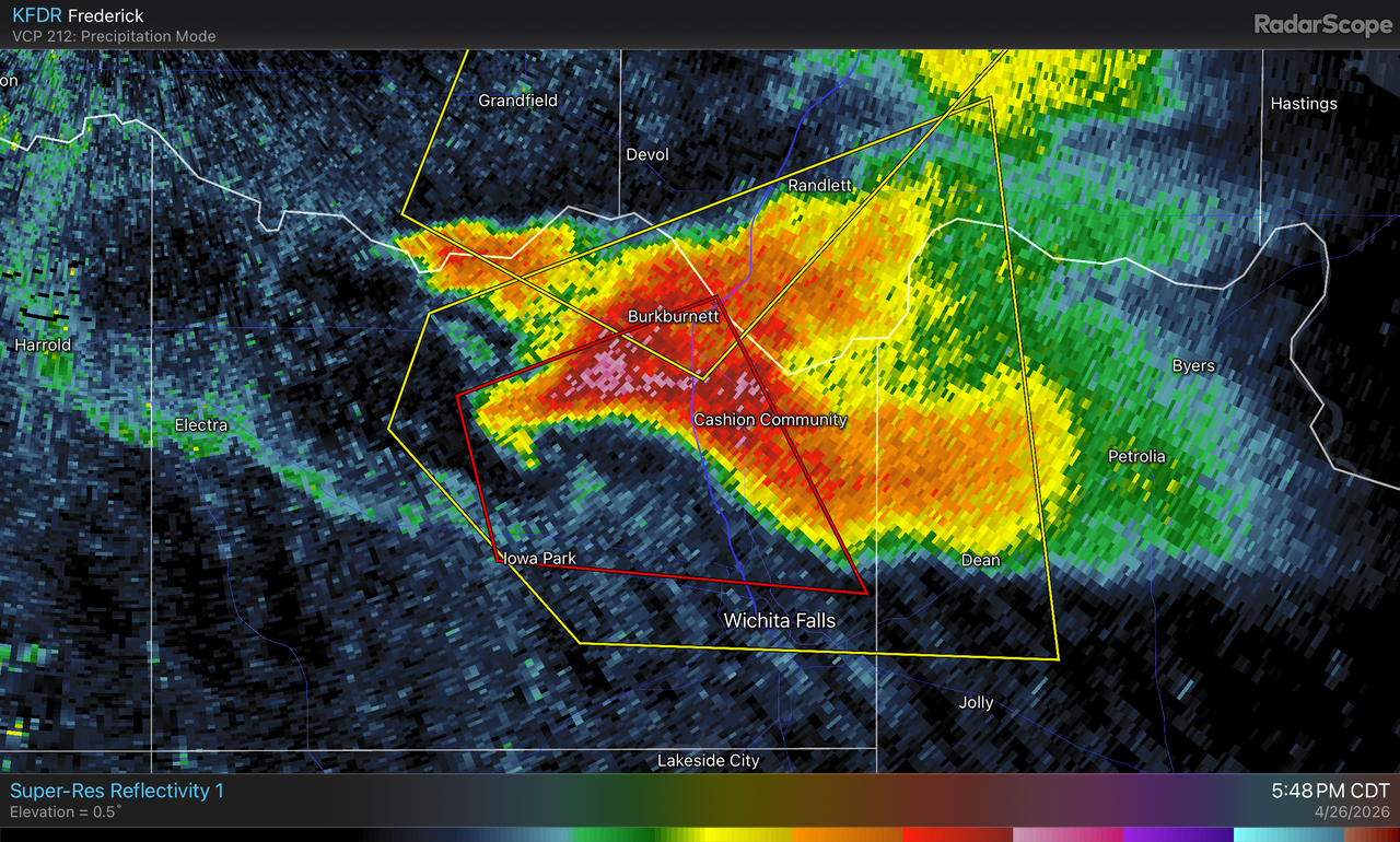

BULLETIN - EAS ACTIVATION REQUESTED
Tornado Warning
National Weather Service Norman OK
547 PM CDT Sun Apr 26 2026
The National Weather Service in Norman has issued a
* Tornado Warning for...
East central Wichita County in northern Texas...
* Until 630 PM CDT.
* At 547 PM CDT, a severe thunderstorm capable of producing a tornado
was located near Iowa Park, moving east at 15 mph.
HAZARD...Tornado and golf ball size hail.
SOURCE...Radar indicated rotation.
IMPACT...Flying debris will be dangerous to those caught without
shelter. Mobile homes will be damaged or destroyed.
Damage to roofs, windows, and vehicles will occur. Tree
damage is likely.
* Locations impacted include...
Northern Wichita Falls, Burkburnett, Iowa Park, Sheppard AFB,
Pleasant Valley, and Cashion.
0 likes
-
txtwister78

- Category 5
- Posts: 2255
- Joined: Wed Jan 30, 2019 12:56 pm
- Location: San Antonio
Re: Texas Spring 2026
Going to miss WF thankfully. North of town. Look out southern Oklahoma.
Classic flying V/flying eagle shaped supercell. Intense updraft. Could be another strong Tornado somewhere along the river into Oklahoma.
Classic flying V/flying eagle shaped supercell. Intense updraft. Could be another strong Tornado somewhere along the river into Oklahoma.
0 likes
-
cheezyWXguy

- Category 5
- Posts: 6284
- Joined: Mon Feb 13, 2006 12:29 am
- Location: Dallas, TX
Return to “USA & Caribbean Weather”
Who is online
Users browsing this forum: Brent, cheezyWXguy, txtwister78 and 20 guests