Texas Fall 2024
Moderator: S2k Moderators
Forum rules

The posts in this forum are NOT official forecast and should not be used as such. They are just the opinion of the poster and may or may not be backed by sound meteorological data. They are NOT endorsed by any professional institution or STORM2K.
-
Stratton23
- Category 5

- Posts: 3563
- Joined: Fri Jul 21, 2023 10:59 pm
- Location: Katy, Tx
Re: Texas Fall 2024
Coldest run of the Euro AIFS yet! 00z run dumping the arctic air right down into the deep heart of texas
2 likes
-
Stratton23
- Category 5
- Posts: 3563
- Joined: Fri Jul 21, 2023 10:59 pm
- Location: Katy, Tx
Re: Texas Fall 2024
And theres the first really crazy GFS run ( 06z is extremely cold with a developing winter storm)
1 likes
-
AubreyStorm

- Category 1

- Posts: 337
- Age: 45
- Joined: Fri Jun 16, 2017 6:21 pm
- Location: Texas, USA
Re: Texas Fall 2024
Stratton23 wrote:And theres the first really crazy GFS run ( 06z is extremely cold with a developing winter storm)
When? I’m on Frisco, Texas

0 likes
The posts are NOT an official forecast. Please REFER to the NHC and NWS for official forecasts and products.
-
HockeyTx82
- S2K Supporter

- Posts: 2795
- Joined: Tue Oct 27, 2009 11:17 am
- Location: Ponder, TX
Re: Texas Fall 2024
AubreyStorm wrote:Stratton23 wrote:And theres the first really crazy GFS run ( 06z is extremely cold with a developing winter storm)
When? I’m on Frisco, Texas
In La La Land. Very end of the run, don't hold your breath.
https://www.pivotalweather.com/model.php
0 likes
Don't hold me accountable for anything I post on this forum. Leave the real forecasting up to the professionals.
Location: Ponder, TX (all observation posts are this location unless otherwise noted)
Location: Ponder, TX (all observation posts are this location unless otherwise noted)

-
Ralph's Weather
- S2K Supporter
- Posts: 3371
- Age: 38
- Joined: Fri Dec 13, 2013 11:55 am
- Location: Lindale, TX
- Contact:
Re: Texas Fall 2024
East Texas ranges from the low 30s in rural areas to the upper 30s in towns. Cars frosted over for the first time this fall here.
1 likes
Follow on Facebook at Ralph's Weather.
Re: Texas Fall 2024
Ralph's Weather wrote:East Texas ranges from the low 30s in rural areas to the upper 30s in towns. Cars frosted over for the first time this fall here.
Yeah finally feels/looks like winter.
0 likes

Re: Texas Fall 2024
1060 MB HP in Montana on December 4th on the 06z GFS. That will do the trick & is exactly what Ntxw and Stratton were alluding to.
2 likes
Re: Texas Fall 2024
Cpv17 wrote:1060 MB HP in Montana on December 4th on the 06z GFS. That will do the trick & is exactly what Ntxw and Stratton were alluding to.
One can dream but I’ve learned not to get my hopes up this far out hopefully by thanksgiving cold still looks promising.
1 likes
-
CaptinCrunch

- S2K Supporter
- Posts: 8780
- Age: 58
- Joined: Mon Nov 03, 2003 4:33 pm
- Location: Kennedale, TX (Tarrant Co.)
Re: Texas Fall 2024
Ralph's Weather wrote:East Texas ranges from the low 30s in rural areas to the upper 30s in towns. Cars frosted over for the first time this fall here.
I had windows open over night, woke up at 5:30am and closed them, it was very chilly in the house. When I left for work about 6:30am part of my windshield was frosty, and the rooftops were very frosty. That's a first for the season, so late is better than never!
0 likes
-
Tireman4

- S2K Supporter
- Posts: 5903
- Age: 60
- Joined: Fri Jun 30, 2006 1:08 pm
- Location: Humble, Texas
- Contact:
Re: Texas Fall 2024
Larry Cosgrove
Increasing North America Snow Cover And High-Latitude Blocking Signatures Imply Colder Changes To The Seasonal Forecast
Let it snow! For the more that the snowpack increases across Canada and the northern states, the opportunity to build an Arctic air mass will expand as well. If, however, the coverage maps lessen and "turn green" across Ontario and Quebec, then regimes will have a shorter life and less penetration into the southern half of the lower 48 states this winter.
Opportunities for colder weather are increasing over the next three weeks. The emergence of -EPO (Alaska) and -NAO (Davis Strait) blocking ridges enhances the buckling of the jet stream, as a broad Hudson Bay vortex will form in between the two positive height anomalies. Shortwaves that form across the Northwest Territories and Nunavut AR rotate around the gyre and deepen the cold pool in the Prairie Provinces, which then head south in a trough across the middle of the continent. If that troughing is full-latitude (stretching into Texas and Louisiana), then the cold air will be able to reach further south and east. But should teh flow remain only modestly amplified, then the southern and eastern portions of the nation will see warm-ups, some of which will be quite impressive.
Driving all of this wintry pattern (which will have peaks east of the Rocky Mountains between November 30 and December 11) is tropical forcing, which is linked to the polar westerlies crossing the International Dateline. Part of the Madden-Julian Oscillation, the impulse in the central equatorial Pacific Basin is also feeding a subtropical jet stream that has hooked up with the storm and front along the East Coast. If the MJO remains strong, in Phases 6 - 8 into 1, both wind fields will remain intense and supportive of deeper and more southerly tracking storms. But should the convection retrogress to the Indian Ocean and Maritime Continent, risks for high heating demand and snowfall will be reduced.
I had to make some changes to my winter forecast, which now includes some colder turns in the south central and Northeast in the DJF time frame. As we alternate between the two cold vs, warm scenarios, there will at least be some potential for true winter weather in places like Frisco TX and Rising Sun MD. "Back and forth" is better than another snowless and mild winter, right?
4 likes
-
CaptinCrunch
- S2K Supporter
- Posts: 8780
- Age: 58
- Joined: Mon Nov 03, 2003 4:33 pm
- Location: Kennedale, TX (Tarrant Co.)
Re: Texas Fall 2024
Tireman4 wrote:Larry Cosgrove
Increasing North America Snow Cover And High-Latitude Blocking Signatures Imply Colder Changes To The Seasonal Forecast
Let it snow! For the more that the snowpack increases across Canada and the northern states, the opportunity to build an Arctic air mass will expand as well. If, however, the coverage maps lessen and "turn green" across Ontario and Quebec, then regimes will have a shorter life and less penetration into the southern half of the lower 48 states this winter.
Opportunities for colder weather are increasing over the next three weeks. The emergence of -EPO (Alaska) and -NAO (Davis Strait) blocking ridges enhances the buckling of the jet stream, as a broad Hudson Bay vortex will form in between the two positive height anomalies. Shortwaves that form across the Northwest Territories and Nunavut AR rotate around the gyre and deepen the cold pool in the Prairie Provinces, which then head south in a trough across the middle of the continent. If that troughing is full-latitude (stretching into Texas and Louisiana), then the cold air will be able to reach further south and east. But should teh flow remain only modestly amplified, then the southern and eastern portions of the nation will see warm-ups, some of which will be quite impressive.
Driving all of this wintry pattern (which will have peaks east of the Rocky Mountains between November 30 and December 11) is tropical forcing, which is linked to the polar westerlies crossing the International Dateline. Part of the Madden-Julian Oscillation, the impulse in the central equatorial Pacific Basin is also feeding a subtropical jet stream that has hooked up with the storm and front along the East Coast. If the MJO remains strong, in Phases 6 - 8 into 1, both wind fields will remain intense and supportive of deeper and more southerly tracking storms. But should the convection retrogress to the Indian Ocean and Maritime Continent, risks for high heating demand and snowfall will be reduced.
I had to make some changes to my winter forecast, which now includes some colder turns in the south central and Northeast in the DJF time frame. As we alternate between the two cold vs, warm scenarios, there will at least be some potential for true winter weather in places like Frisco TX and Rising Sun MD. "Back and forth" is better than another snowless and mild winter, right?
Just so you get a better PIC of the source regions
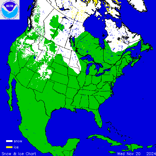
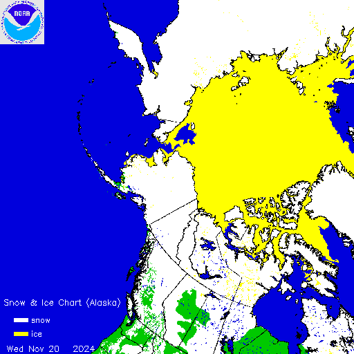
3 likes
-
TeamPlayersBlue

- Category 5
- Posts: 3531
- Joined: Tue Feb 02, 2010 1:44 am
- Location: Denver/Applewood, CO
Re: Texas Fall 2024
CaptinCrunch wrote:
Just so you get a better PIC of the source regions
https://usicecenter.gov/products/ims/ims_v3/ims_gif/ARCHIVE/USA/2024/ims2024325_usa.gif
https://usicecenter.gov/products/ims/ims_v3/ims_gif/ARCHIVE/AK/2024/ims2024325_alaska.gif
That will make a huge difference. Ice cap has fill in the gap to Alaska, so now it wont modify the air at all as it passes over the region. More snow cover over Alberta certainly wouldnt hurt either. As a big storm comes down, it would likely produce enough snow itself to fill in the gaps in Alberta as well.
0 likes
Personal Forecast Disclaimer:
The posts in this forum are NOT official forecast and should not be used as such. They are just the opinion of the poster and may or may not be backed by sound meteorological data. They are NOT endorsed by any professional institution or storm2k.org. For official information, please refer to the NHC and NWS products.
The posts in this forum are NOT official forecast and should not be used as such. They are just the opinion of the poster and may or may not be backed by sound meteorological data. They are NOT endorsed by any professional institution or storm2k.org. For official information, please refer to the NHC and NWS products.
-
Brent
- S2K Supporter
- Posts: 38754
- Age: 37
- Joined: Sun May 16, 2004 10:30 pm
- Location: Tulsa Oklahoma
- Contact:
Re: Texas Fall 2024
Coldest air of the season showing up on TWC already to start December. This is the first time it's actually shown prolonged cold so something to watch and if its gonna be really cold it'll trend colder as we get closer
0 likes
#neversummer
-
Stratton23
- Category 5
- Posts: 3563
- Joined: Fri Jul 21, 2023 10:59 pm
- Location: Katy, Tx
Re: Texas Fall 2024
As expected the operational models continue to flip flop or struggle with seeing the cold air, ensembles look great, probably will be at least another 4-5 days before the operational runs really catch on to this, happens every time with cold air masses
0 likes


Re: Texas Fall 2024
Stratton23 wrote:As expected the operational models continue to flip flop or struggle with seeing the cold air, ensembles look great, probably will be at least another 4-5 days before the operational runs really catch on to this, happens every time with cold air masses
Not too concerned with run to run OP models. The ensembles are trending colder, considering 7-10 days away.

4 likes
The above post and any post by Ntxw is NOT an official forecast and should not be used as such. It is just the opinion of the poster and may or may not be backed by sound meteorological data. It is NOT endorsed by any professional institution including Storm2k. For official information, please refer to NWS products.
Help support Storm2K!
Re: Texas Fall 2024
Middle December 1989 continues to be the recurring analog in the medium long range.

Now before we jump on record cold, consider a couple of factors. The similarities is a good Pacific pattern at 500mb. The ridging is potent like that year, however the surface cold up north is not the same. Remember it's what's on the ground alongside what kind of delivery flow. Will be great delivery flow, but what will the cold quality be? More certainty that December will likely start out cold.

Now before we jump on record cold, consider a couple of factors. The similarities is a good Pacific pattern at 500mb. The ridging is potent like that year, however the surface cold up north is not the same. Remember it's what's on the ground alongside what kind of delivery flow. Will be great delivery flow, but what will the cold quality be? More certainty that December will likely start out cold.
1 likes
The above post and any post by Ntxw is NOT an official forecast and should not be used as such. It is just the opinion of the poster and may or may not be backed by sound meteorological data. It is NOT endorsed by any professional institution including Storm2k. For official information, please refer to NWS products.
Help support Storm2K!
Help support Storm2K!
-
Stratton23
- Category 5
- Posts: 3563
- Joined: Fri Jul 21, 2023 10:59 pm
- Location: Katy, Tx
Re: Texas Fall 2024
Also ensembles are decently active in terms of systems/ precipitation, will need to watch if we get a system to meet up with the cold air, the 6z GFS alluded to this
0 likes
-
Brent
- S2K Supporter
- Posts: 38754
- Age: 37
- Joined: Sun May 16, 2004 10:30 pm
- Location: Tulsa Oklahoma
- Contact:
Re: Texas Fall 2024
There's definitely some snowy ensembles here which is a good sign at day 10 especially
Can't get caught up in the op runs like they said
Personally I'd be surprised if we get a real snow in early December but nobody thought we'd get a foot of rain this month either never say never
Can't get caught up in the op runs like they said
Personally I'd be surprised if we get a real snow in early December but nobody thought we'd get a foot of rain this month either
0 likes
#neversummer
-
rwfromkansas
- Category 5
- Posts: 3038
- Joined: Sat Aug 27, 2005 12:47 am
- Location: North Fort Worth
Re: Texas Fall 2024
Like the Cosgrove update about modifying his winter forecast with more cold/snow.
0 likes
Return to “USA & Caribbean Weather”
Who is online
Users browsing this forum: mmmmsnouts and 85 guests