I had to fly back to Alabama last night because my grandfather died and it's gonna be cold here... 45 tonight, 41 tomorrow night. Atlanta met teasing the 11pm news just said "winterlike" conditions possible in some areas.
Today was up in the low 80s though, almost as warm as Dallas was today.
Texas Fall-2015
Moderator: S2k Moderators
Forum rules

The posts in this forum are NOT official forecast and should not be used as such. They are just the opinion of the poster and may or may not be backed by sound meteorological data. They are NOT endorsed by any professional institution or STORM2K.
-
Rgv20

- S2K Supporter

- Posts: 2466
- Age: 39
- Joined: Wed Jan 05, 2011 5:42 pm
- Location: Edinburg/McAllen Tx
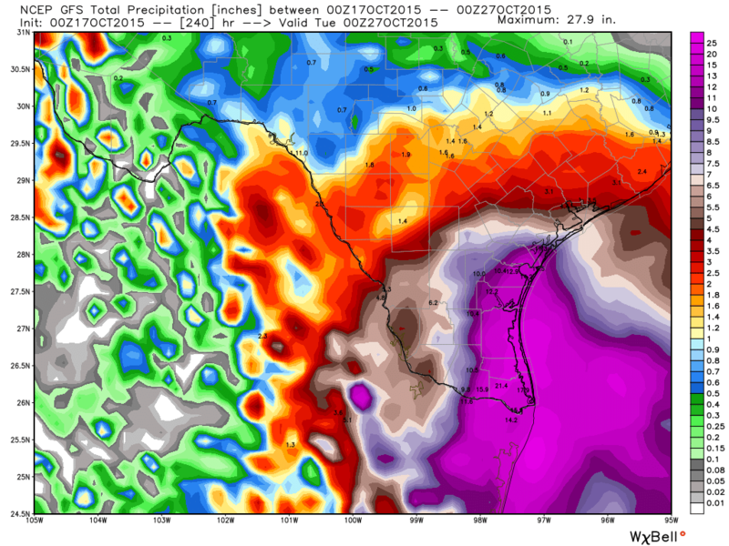
Tonight's 0zGFS has some crazy rainfall totals for much of South Texas thru Day 10! 

0 likes
The following post is NOT an official forecast and should not be used as such. It is just the opinion of the poster and may or may not be backed by sound meteorological data. It is NOT endorsed by any professional institution including storm2k.org For Official Information please refer to the NHC and NWS products.

Re: Texas Fall-2015
Brent wrote:I had to fly back to Alabama last night because my grandfather died and it's gonna be cold here... 45 tonight, 41 tomorrow night. Atlanta met teasing the 11pm news just said "winterlike" conditions possible in some areas.
Today was up in the low 80s though, almost as warm as Dallas was today.
Sorry to hear that Brent.
0 likes
The above post and any post by dhweather is NOT an official forecast and should not be used as such. It is just the opinion of the poster and may or may not be backed by sound meteorological data. It is NOT endorsed by any professional institution including storm2k.org. For official information, please refer to NWS products.
-
weatherdude1108
- Category 5

- Posts: 4228
- Joined: Tue Dec 13, 2011 1:04 pm
- Location: Northwest Austin/Cedar Park, TX
Re: Texas Fall-2015
dhweather wrote:Brent wrote:I had to fly back to Alabama last night because my grandfather died and it's gonna be cold here... 45 tonight, 41 tomorrow night. Atlanta met teasing the 11pm news just said "winterlike" conditions possible in some areas.
Today was up in the low 80s though, almost as warm as Dallas was today.
Sorry to hear that Brent.
Ditto. Sorry for your loss Brent.
0 likes
The preceding post is NOT an official forecast, and should not be used as such. It is only the opinion of the poster and may or may not be backed by sound meteorological data. It is NOT endorsed by any professional institution including storm2k.org. For Official Information please refer to the NHC and NWS products.
-
weatherdude1108
- Category 5
- Posts: 4228
- Joined: Tue Dec 13, 2011 1:04 pm
- Location: Northwest Austin/Cedar Park, TX
Hoping this forecast package verifies! 
AREA FORECAST DISCUSSION
NATIONAL WEATHER SERVICE AUSTIN/SAN ANTONIO TX
321 PM CDT SAT OCT 17 2015
.LONG TERM (MONDAY THROUGH SATURDAY)...
HUMIDITY VALUES/MOISTURE WILL INCREASE ON MONDAY AS SOUTHERLY
WINDS RETURN TO THE AREA AND A SURFACE HIGH PRESSURE SYSTEM OVER
THE OHIO VALLEY PUSHES TO THE EAST. BY THE MIDDLE OF NEXT
WEEK...AN UPPER LEVEL STORM SYSTEM IS FORECAST TO PUSH ACROSS THE
DESERT SOUTHWEST AND CONTINUING OVER THE FOUR REGIONS CORNER AS
AN OPEN WAVE WHILE PUSHING TO THE SOUTHERN PLAINS. AT THE
SURFACE...A TROPICAL DISTURBANCE IS FORECAST TO DEVELOP EARLY NEXT
WEEK OVER THE SOUTHWEST GULF OF MEXICO WATERS AND PULL TO THE
NORTHWEST. BY THURSDAY NIGHT...THE SURFACE LOW IS FORECAST TO MOVE
OVER THE BROWNSVILLE AREA AND CONTINUE ALONG THE TEXAS COASTS
THROUGH FRIDAY. WITH DEEPER MOISTURE COMING IN FROM THE GULF AND
FORECAST PWS VALUES RANGING FROM 1.5 TO 2.36 ACROSS THE
AREA...EXPECT EPISODES OF MODERATE TO HEAVY RAIN. MEDIUM RANGE
MODELS ARE IN GOOD AGREEMENT THROUGH EARLY FRIDAY AND THEN DIFFER
INTO NEXT WEEKEND.
AT THIS TIME...IT HARD TO TELL WHERE THE HIGHEST RAINFALL AMOUNTS
WILL FALL...HOWEVER...IF THIS FORECAST PACKAGE VERIFIES...ALL OF
SOUTH CENTRAL SHOULD GET MEASURABLE RAINFALL AMOUNTS.
0 likes
The preceding post is NOT an official forecast, and should not be used as such. It is only the opinion of the poster and may or may not be backed by sound meteorological data. It is NOT endorsed by any professional institution including storm2k.org. For Official Information please refer to the NHC and NWS products.
-
Portastorm

- Storm2k Moderator

- Posts: 9955
- Age: 63
- Joined: Fri Jul 11, 2003 9:16 am
- Location: Round Rock, TX
- Contact:
Re: Texas Fall-2015
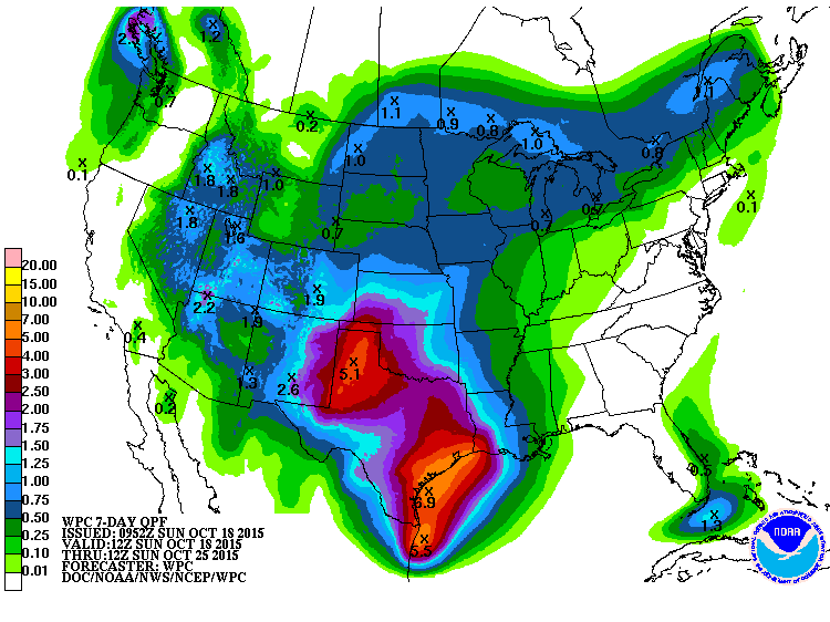
Latest QPF totals per the WPC says close to 3" of rain for SC Texas by next Saturday. Some models showing more. Looks to be the ol' Western Gulf slopgyre as my pal srainhoutx calls 'em. Combine that with a front and incoming energy from the Four Corners area and we've got a heavy rain trifecta.
0 likes
Any forecasts under my name are to be taken with a grain of salt. Get your best forecasts from the National Weather Service and National Hurricane Center.

-
South Texas Storms

- Professional-Met

- Posts: 4260
- Joined: Thu Jun 24, 2010 12:28 am
- Location: Houston, TX
Re: Texas Fall-2015
Brent wrote:I had to fly back to Alabama last night because my grandfather died and it's gonna be cold here... 45 tonight, 41 tomorrow night. Atlanta met teasing the 11pm news just said "winterlike" conditions possible in some areas.
Today was up in the low 80s though, almost as warm as Dallas was today.
Sorry for your loss Brent.
0 likes
-
weatherdude1108
- Category 5
- Posts: 4228
- Joined: Tue Dec 13, 2011 1:04 pm
- Location: Northwest Austin/Cedar Park, TX
Re: Texas Fall-2015
Portastorm wrote:Latest QPF totals per the WPC says close to 3" of rain for SC Texas by next Saturday. Some models showing more. Looks to be the ol' Western Gulf slopgyre as my pal srainhoutx calls 'em. Combine that with a front and incoming energy from the Four Corners area and we've got a heavy rain trifecta.

0 likes
-
Brent
- S2K Supporter
- Posts: 38757
- Age: 37
- Joined: Sun May 16, 2004 10:30 pm
- Location: Tulsa Oklahoma
- Contact:
Re: Texas Fall-2015
Frost advisory here where I am in Alabama tonight...  Crazy change from Dallas the other day... I'll be back Monday Night.
and thanks everyone.
Crazy change from Dallas the other day... I'll be back Monday Night.and thanks everyone.
0 likes
#neversummer
-
Texas Snowman

- Storm2k Moderator
- Posts: 6197
- Joined: Fri Jan 25, 2008 11:29 am
- Location: Denison, Texas
Re: Texas Fall-2015
Brent wrote:Frost advisory here where I am in Alabama tonight...
and thanks everyone.
Brent, I'm very sorry for the loss of your grandfather. I'm praying tonight for you and your family.
0 likes
The above post and any post by Texas Snowman is NOT an official forecast and should not be used as such. It is just the opinion of the poster and may or may not be backed by sound meteorological data. It is NOT endorsed by any professional institution including storm2k.org. For official information, please refer to NWS products.
-
srainhoutx

- S2K Supporter
- Posts: 6919
- Age: 68
- Joined: Sun Jan 14, 2007 11:34 am
- Location: Haywood County, NC
- Contact:
Re: Texas Fall-2015
The overnight Global computer guidance is slowly coming into agreement that Texas and our surrounding Region is headed toward a significant pattern change beginning Tuesday afternoon extending into next weekend.
A combination of a very deep longwave trough that features a closed 500mb low at the base of the trough over Northern Mexico and Southern Arizona along with a very unsettled area of lowering pressure across the Gulf of Tehuantepec extending East into the NW Caribbean Sea and a stalling frontal boundary across Central Texas mid week offer a recipe for a potential very heavy rainfall event for much of the Lone Star State.
Moisture levels across the Bay of Campeche are running greater than 2.5 inches this morning with even deeper moisture across the Eastern Pacific extending East into Central America and the NW Caribbean Sea. A broad area of low pressure at the surface associated with a monsoonal trough looks to begin surging North across Central Mexico and the Western Gulf on Tuesday. Moisture levels are expected to reach and possibly exceed 2 standard deviation above normal for this time of year across our Region Wednesday into Thursday. Embedded disturbances rotating beneath the Western trough from a very noisy sub tropical jet as well as a Coastal trough along the Lower and Middle Texas Coast suggest some locations may receive 5 to 7 inches of heavy rainfall with isolated higher amounts nearing 10 inches, if the Western trough meanders longer than expected. This is a complicated and complex forecast challenge, so expect day to day changes as the week ahead unfolds. Next Friday and Saturday could be particularly stormy with all modes of severe weather possible. More later on this developing weather situation.
0 likes
Carla/Alicia/Jerry(In The Eye)/Michelle/Charley/Ivan/Dennis/Katrina/Rita/Wilma/Ike/Harvey
Member: National Weather Association
Wx Infinity Forums
http://wxinfinity.com/index.php
Facebook.com/WeatherInfinity
Twitter @WeatherInfinity
Member: National Weather Association
Wx Infinity Forums
http://wxinfinity.com/index.php
Facebook.com/WeatherInfinity
Twitter @WeatherInfinity

Quite a good set up for the state, better than last week. Invest 92L in the Yucatan will overspread low level moisture. 97E in the Epac could become a hurricane that may prevent 92L from organizing. This scenario with a sitting ULL draws the moisture at the low levels from 92L and higher moisture from 97E. With a ridge to our east its a good block to keep it in place. Some may end up with more rain than they bargained for
Kudos to the CPC for their probabilities
Kudos to the CPC for their probabilities
0 likes
The above post and any post by Ntxw is NOT an official forecast and should not be used as such. It is just the opinion of the poster and may or may not be backed by sound meteorological data. It is NOT endorsed by any professional institution including Storm2k. For official information, please refer to NWS products.
Help support Storm2K!
-
Portastorm
- Storm2k Moderator
- Posts: 9955
- Age: 63
- Joined: Fri Jul 11, 2003 9:16 am
- Location: Round Rock, TX
- Contact:
Re: Texas Fall-2015
Nice forecast note, srainhoutx! Thank you for sharing that. Also appreciate Ntxw augmenting it. All in all our rain chances are looking encouraging for the next week. Would like nothing more than to see it douse the Hidden Pines Fire and the rest of the wildfires in the state. Should be an interesting weather week for most of us in Texas.
0 likes
Any forecasts under my name are to be taken with a grain of salt. Get your best forecasts from the National Weather Service and National Hurricane Center.
500mb flow from 12z GFS is ideal. Opens up the southern plains for widespread heavy rains much like late spring. A couple of 500mb troughs to the west


0 likes
The above post and any post by Ntxw is NOT an official forecast and should not be used as such. It is just the opinion of the poster and may or may not be backed by sound meteorological data. It is NOT endorsed by any professional institution including Storm2k. For official information, please refer to NWS products.
Help support Storm2K!
Help support Storm2K!
-
srainhoutx
- S2K Supporter
- Posts: 6919
- Age: 68
- Joined: Sun Jan 14, 2007 11:34 am
- Location: Haywood County, NC
- Contact:
Re: Texas Fall-2015
The MJO is going bonkers suggesting a robust Phase 1 episode. That bodes well for a continuation of a generally Western trough/Eastern Ridge with a bit of blocking across the far N Pacific. I suspect the pattern about to unfold will persist until at least early November. That would mean a very unsettled pattern across Texas, New Mexico, Mexico and the Southern Plains. Now we will have to watch the Eastern Pacific for recurving tropical cyclones beneath the base of the Western trough.
0 likes
Carla/Alicia/Jerry(In The Eye)/Michelle/Charley/Ivan/Dennis/Katrina/Rita/Wilma/Ike/Harvey
Member: National Weather Association
Wx Infinity Forums
http://wxinfinity.com/index.php
Facebook.com/WeatherInfinity
Twitter @WeatherInfinity
Member: National Weather Association
Wx Infinity Forums
http://wxinfinity.com/index.php
Facebook.com/WeatherInfinity
Twitter @WeatherInfinity
Re: Texas Fall-2015
srainhoutx wrote:The MJO is going bonkers suggesting a robust Phase 1 episode. That bodes well for a continuation of a generally Western trough/Eastern Ridge with a bit of blocking across the far N Pacific. I suspect the pattern about to unfold will persist until at least early November. That would mean a very unsettled pattern across Texas, New Mexico, Mexico and the Southern Plains. Now we will have to watch the Eastern Pacific for recurving tropical cyclones beneath the base of the Western trough.
Great catch! It will be quite robust. That definitely helps amplify the pattern and tropical forcing is shifting further east with it across the equatorial Pacific. For the past few weeks it's been stagnant over near the dateline promoting the continuous wet conditions across the southwest and southern rockies but did not progress eastward to the southern plains aside from far west Texas. This eastward shift will move everything along.
Near 100W (between 120W and 60W) is our region. Seeing blues and pinks there means lots of rising motion.

0 likes
The above post and any post by Ntxw is NOT an official forecast and should not be used as such. It is just the opinion of the poster and may or may not be backed by sound meteorological data. It is NOT endorsed by any professional institution including Storm2k. For official information, please refer to NWS products.
Help support Storm2K!
Help support Storm2K!
-
srainhoutx
- S2K Supporter
- Posts: 6919
- Age: 68
- Joined: Sun Jan 14, 2007 11:34 am
- Location: Haywood County, NC
- Contact:
Re: Texas Fall-2015
Afternoon briefing from Jeff:
Potentially impactful weather event for the end of the week into next week for much of the region.
Upper level pattern will undergo significant changes this week with the upper level ridge which has dominated our weather for the last several weeks breaking down and being replaced with a strong upper level trough over the SW USW. An eastern Pacific tropical system will likely develop along the Mexican coast and move slowly NW then NNW and become captured into the trough over the SW US resulting in extensive moisture advection northward from the eastern Pacific. Large mass of deep tropical moisture over the Bay of Campeche will be released northward starting Monday arriving into SE TX on Tuesday. Moisture deepens into Friday and Saturday peaking near record levels for late October. Upper level trough will edge slowly eastward over this week allowing increasing lift aloft. At the same time models continue to attempt to develop some sort of western Gulf of Mexico surface low (possibly tropical or possibly hybrid) and bring this feature into the TX coast Friday night into Saturday. Will favor the less defined GFS solution with this feature over the more defined and stronger ECMWF. A tropical system in the NW Gulf in late October would be rare and think a strong coastal trough or frontal low is more likely. Regardless…impacts will be the same.
Winds are already steady ENE 15-20mph across the coastal waters this morning and will remain steady and slowly increase through the week as pressures lower over the western Gulf and help increase the pressure gradient. Moisture will begin to arrive into the area Tuesday and spread inland/northward on Wednesday. Will go ahead and include 20-30% rain chances Tuesday and 30-40% Wednesday then much more significant chances Thursday-Saturday. Friday and Saturday continue to look extremely wet with increasing potential for prolonged and sustained significant training rainfall event from deep S TX into the coastal bend and SE TX. Model QPF in the Friday-Saturday period continues to be on the heavy to excessive side and profiles support strong southerly flow with near record moisture levels all pointing toward high rainfall totals. Still some disagreement on where exactly the heavy rains will setup and how much…but current model totals would certainly be concerning even with the current dry conditions and would likely result in both flash flooding and possible river flooding.
Marine/Coastal:
Another concern will be increasing marine hazards which will include building seas and potential coastal flooding. Deepening coastal trough/low pressure off the NE MX coast late week will combine with strong high pressure over the SE US to produce a strong E to ESE gradient across nearly the entire northern Gulf of Mexico. Winds will increase into the 15-25mph range on Wednesday and then 20-40mph on Friday. GFS based Wavewatch III shows 8-10 ft seas mid week building to 13-15 ft by late week. Tides will be elevating due to long fetch E winds which is a favorable tidal transport wind toward the upper TX coast. Combination of strong winds and building seas will ramp tides to 1-2.5 ft above normal by Thursday and possibly even higher by Friday. Total water level when combined with possible storm surge could approach 3.5-4.5 ft by Friday which is near our critical flood thresholds on Bolivar, the west end of Galveston, and the west side of Galveston Bay. Will need to keep a close eye on the tides this week as this will be an extended period of coastal impact and could lead to significant beach erosion.
Fire Weather:
Before the big change in the pattern this week…fire weather conditions will remain elevated to near critical especially between noon and 600pm today and Monday NW of US 59. RH will fall into the 15-30% range each afternoon with NE to ENE winds of 10-20mph. Fuels remain critically dry, but thus far fire that started on Saturday were able to be brought under control quickly…with most averaging less than 10 acres.
Hidden Pines Fire:
No significant changes in this complex since Friday with fire lines holding and acreage nearly the same 4582. Thus far 50 structures have burned and over 200 were saved. No additional structures have been lost since Thursday and ground crews have made extensive progress with air support on maintaining fire lines with crews working hot spots deeper within the containment lines. Fire will likely exhibit sporadic activity until wetting rainfall fully ends the threat later this week.
0 likes
Carla/Alicia/Jerry(In The Eye)/Michelle/Charley/Ivan/Dennis/Katrina/Rita/Wilma/Ike/Harvey
Member: National Weather Association
Wx Infinity Forums
http://wxinfinity.com/index.php
Facebook.com/WeatherInfinity
Twitter @WeatherInfinity
Member: National Weather Association
Wx Infinity Forums
http://wxinfinity.com/index.php
Facebook.com/WeatherInfinity
Twitter @WeatherInfinity
Re: Texas Fall-2015
12Z GFS

0 likes
The above post and any post by dhweather is NOT an official forecast and should not be used as such. It is just the opinion of the poster and may or may not be backed by sound meteorological data. It is NOT endorsed by any professional institution including storm2k.org. For official information, please refer to NWS products.
Return to “USA & Caribbean Weather”
Who is online
Users browsing this forum: A1A, AnnularCane, Cpv17, cstrunk and 108 guests