Texas Fall-2015
Moderator: S2k Moderators
Forum rules
The posts in this forum are NOT official forecast and should not be used as such. They are just the opinion of the poster and may or may not be backed by sound meteorological data. They are NOT endorsed by any professional institution or STORM2K.
Re: Texas Fall-2015
I passed a wildfire a few miles north of US79 on my way home from work today traveling from Palestine to Jacksonville. It reportedly crossed the Neches and spread into Cherokee county from Anderson county which surprised me if true.
0 likes
- srainhoutx
- S2K Supporter

- Posts: 6919
- Age: 68
- Joined: Sun Jan 14, 2007 11:34 am
- Location: Haywood County, NC
- Contact:
Re: Texas Fall-2015
The main forecast challenge via the 00Z Global computer guidance is the longwave trough to our West and does it wrap up into a very slow moving closed 500mb upper low over Northern Mexico/Southern Arizona and the eventual development of a Coastal trough across the Lower/Middle Texas Coast late next week. There have been indications of a tropical system organizing in the Gulf of Tehuatepec in the Eastern Pacific eventually crossing into the Bay of Campeche/Western Gulf and organizing into a tropical cyclone or hybrid low moving N to NNE toward the Texas/Louisiana Coast next weekend. The only concern is the computer models with each run have delayed this Western Gulf low, which raises an eyebrow. That said satellite imagery does suggest increasing moisture developing across Central America and the NW Caribbean Sea and virtually all the reliable computer models agree that there is some potential of a 850mb low with a surface reflection possible near Tampico by next Thursday complicating the sensible weather forecast. What we do know this morning is that the HPC/WPC has increased the QPF dramatically for Coastal Texas in the Day 6 to 7 timeframe. The key to future forecast trends will be the trough to our West and just how slow it advances East next week. This is a complicated and low confidence forecast at this time. Should the trends continue, Coastal flooding issues due to a persistent long fetch Easterly flow also enter the picture adding to an already challenging forecast. Stay tuned!
0 likes
Carla/Alicia/Jerry(In The Eye)/Michelle/Charley/Ivan/Dennis/Katrina/Rita/Wilma/Ike/Harvey
Member: National Weather Association
Wx Infinity Forums
http://wxinfinity.com/index.php
Facebook.com/WeatherInfinity
Twitter @WeatherInfinity
Member: National Weather Association
Wx Infinity Forums
http://wxinfinity.com/index.php
Facebook.com/WeatherInfinity
Twitter @WeatherInfinity
-
weatherdude1108
- Category 5

- Posts: 4228
- Joined: Tue Dec 13, 2011 1:04 pm
- Location: Northwest Austin/Cedar Park, TX
Which model will win? Flip flop flip flop flip flop....

AREA FORECAST DISCUSSION
NATIONAL WEATHER SERVICE AUSTIN/SAN ANTONIO TX
620 AM CDT FRI OCT 16 2015
LONG TERM (SATURDAY NIGHT THROUGH THURSDAY)...
THE EASTERLY LOW LEVEL FLOW SHOULD PERSIST THROUGH THE WEEKEND AND
DELAY MOISTURE FROM RETURNING TO THE AREA UNTIL LATE MONDAY.
THEREFORE ELEVATED FIRE WEATHER CONDITIONS WILL CONTINUE THROUGH
THE WEEKEND AS WELL.
THE GOOD NEWS IS THAT FROM LATE TUESDAY THROUGH THE NEXT WEEKEND
POPS WILL BE IN THE FORECAST...AND EVEN SIGNIFICANT RAINS ARE
POSSIBLE FOR MANY AREAS THAT COULD USE IT. AN UPPER LEVEL SYSTEM
HAS BEEN FAIRLY WELL AGREED UPON IN THE MODELS THE LAST FEW
DAYS...AT LEAST IN THE UPPER LEVELS. BY WEDNESDAY MORNING...THE
CENTER OF THE LOW LOOKS TO BRIEFLY STALL OVER ARIZONA BEFORE
MAKING ITS MORE EASTWARD PROGRESSION THURSDAY. ALSO...AT THE 850
MB LEVEL...A STRONG SOUTHEAST LLJ DEVELOPS MOISTENING THE
ATMOSPHERE QUITE EFFICIENTLY...ENOUGH TO PUSH PWAT VALUES OVER 2
INCHES POSSIBLY BY THURSDAY MORNING. THE COMBINATION OF THE UPPER
LOW AND THE RICH MOISTURE SHOULD RESULT IN SHOWERS AND
THUNDERSTORMS MUCH OF THE LATE WEEK...WITH SOME POTENTIALLY HEAVY
RAINS AS WELL.
THE NEXT EYE OPENER IN THE LONG TERM FORECAST IS A LOW CROSSING
THE SOUTHERN TIP OF CENTRAL AMERICA AND ENTERING THE WESTERN GULF
LATE THURSDAY. BOTH GFS AND ECMWF MODELS INTENSIFY THIS LOW AFTER
IT ENTERS THE WARM GULF WATERS AND COULD EITHER RESULT IN AN
EXTENDED WET PERIOD FOR US IF IT TAKES A NORTHWARD PATH LIKE THE
GFS ADVERTISES. OR IT COULD RESULT IN SOUTH CENTRAL TEXAS MISSING
OUT OF MUCH OF THE RAIN AS IT PASSES BY AND TAKES A MORE NORTHEAST
TRACK AS THE EURO SUGGESTS. AS THIS IS BEYOND THE 180 HR TIME
FRAME...WILL DEFER TO LATER RUNS FOR ADDED DETAILS.
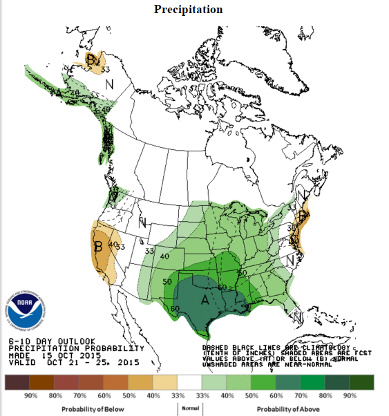
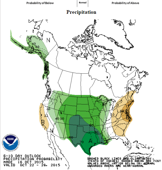
Five days out, but encouraging graphic for next Wednesday. Can't come soon enough!

A dry airmass will linger Saturday and Sunday creating elevated fire weather conditions due to low afternoon humidities and briefly gusty winds. Moisture increases ahead of an upper level disturbance next week leading to isolated showers and thunderstorms on Tuesday, becoming more widespread through the remainder of next week.


AREA FORECAST DISCUSSION
NATIONAL WEATHER SERVICE AUSTIN/SAN ANTONIO TX
620 AM CDT FRI OCT 16 2015
LONG TERM (SATURDAY NIGHT THROUGH THURSDAY)...
THE EASTERLY LOW LEVEL FLOW SHOULD PERSIST THROUGH THE WEEKEND AND
DELAY MOISTURE FROM RETURNING TO THE AREA UNTIL LATE MONDAY.
THEREFORE ELEVATED FIRE WEATHER CONDITIONS WILL CONTINUE THROUGH
THE WEEKEND AS WELL.
THE GOOD NEWS IS THAT FROM LATE TUESDAY THROUGH THE NEXT WEEKEND
POPS WILL BE IN THE FORECAST...AND EVEN SIGNIFICANT RAINS ARE
POSSIBLE FOR MANY AREAS THAT COULD USE IT. AN UPPER LEVEL SYSTEM
HAS BEEN FAIRLY WELL AGREED UPON IN THE MODELS THE LAST FEW
DAYS...AT LEAST IN THE UPPER LEVELS. BY WEDNESDAY MORNING...THE
CENTER OF THE LOW LOOKS TO BRIEFLY STALL OVER ARIZONA BEFORE
MAKING ITS MORE EASTWARD PROGRESSION THURSDAY. ALSO...AT THE 850
MB LEVEL...A STRONG SOUTHEAST LLJ DEVELOPS MOISTENING THE
ATMOSPHERE QUITE EFFICIENTLY...ENOUGH TO PUSH PWAT VALUES OVER 2
INCHES POSSIBLY BY THURSDAY MORNING. THE COMBINATION OF THE UPPER
LOW AND THE RICH MOISTURE SHOULD RESULT IN SHOWERS AND
THUNDERSTORMS MUCH OF THE LATE WEEK...WITH SOME POTENTIALLY HEAVY
RAINS AS WELL.
THE NEXT EYE OPENER IN THE LONG TERM FORECAST IS A LOW CROSSING
THE SOUTHERN TIP OF CENTRAL AMERICA AND ENTERING THE WESTERN GULF
LATE THURSDAY. BOTH GFS AND ECMWF MODELS INTENSIFY THIS LOW AFTER
IT ENTERS THE WARM GULF WATERS AND COULD EITHER RESULT IN AN
EXTENDED WET PERIOD FOR US IF IT TAKES A NORTHWARD PATH LIKE THE
GFS ADVERTISES. OR IT COULD RESULT IN SOUTH CENTRAL TEXAS MISSING
OUT OF MUCH OF THE RAIN AS IT PASSES BY AND TAKES A MORE NORTHEAST
TRACK AS THE EURO SUGGESTS. AS THIS IS BEYOND THE 180 HR TIME
FRAME...WILL DEFER TO LATER RUNS FOR ADDED DETAILS.
Five days out, but encouraging graphic for next Wednesday. Can't come soon enough!

A dry airmass will linger Saturday and Sunday creating elevated fire weather conditions due to low afternoon humidities and briefly gusty winds. Moisture increases ahead of an upper level disturbance next week leading to isolated showers and thunderstorms on Tuesday, becoming more widespread through the remainder of next week.

0 likes
The preceding post is NOT an official forecast, and should not be used as such. It is only the opinion of the poster and may or may not be backed by sound meteorological data. It is NOT endorsed by any professional institution including storm2k.org. For Official Information please refer to the NHC and NWS products.
- CaptinCrunch
- S2K Supporter

- Posts: 8780
- Age: 58
- Joined: Mon Nov 03, 2003 4:33 pm
- Location: Kennedale, TX (Tarrant Co.)
Lets hope the gulf system (probably not) remains weak and more development is on the EPAC. That way the ULL can draw upper moisture from the Pacific and low level moisture in from the gulf. That's more ideal rainfall set up than the wound up system in the gulf creating subsidence. At least the mid October heat wave is over
California had some dramatic flooding and mudslides yesterday and people in cars swept away. We don't need that kind of drama but we could sure use that rain
California had some dramatic flooding and mudslides yesterday and people in cars swept away. We don't need that kind of drama but we could sure use that rain
0 likes
The above post and any post by Ntxw is NOT an official forecast and should not be used as such. It is just the opinion of the poster and may or may not be backed by sound meteorological data. It is NOT endorsed by any professional institution including Storm2k. For official information, please refer to NWS products.
Re: Texas Fall-2015
0 likes
The above post and any post by dhweather is NOT an official forecast and should not be used as such. It is just the opinion of the poster and may or may not be backed by sound meteorological data. It is NOT endorsed by any professional institution including storm2k.org. For official information, please refer to NWS products.
Re: Texas Fall-2015
The FWD AFD
THE DRY AND PLEASANT WEATHER WILL CONTINUE ON MONDAY AS THE
OVERALL PATTERN BEGINS TO UNDERGO A CHANGE. THE UPPER LEVEL RIDGE
THAT HAS BEEN PARKED TO OUR WEST WILL SHIFT EAST THIS WEEKEND AS
THE UPPER LEVEL LOW CURRENTLY OFF THE COAST OF CALIFORNIA MOVES
ONSHORE. THIS LOW WILL WEAKEN AND BECOME ABSORBED INTO ANOTHER
TROUGH MOVING INTO THE PACIFIC NORTHWEST. BY TUESDAY...THE MODELS
DEVELOP A CUT OFF LOW IN THE BASE OF THE TROUGH THAT PARKS OVER
ARIZONA/NEW MEXICO FOR A FEW DAYS. EVENTUALLY A STRONGER SYSTEM
MOVING INTO THE PACIFIC NORTHWEST KICKS THE CUT OFF LOW INTO THE
PLAINS AROUND THE END OF NEXT WEEK. WHILE THE GFS AND ECMWF ARE IN
FAIRLY GOOD AGREEMENT WITH THIS OVERALL PATTERN ON THEIR
RESPECTIVE 00Z RUNS...SOME CAUTION IS NOTED AS THE MODELS HAVE
SHOWN SOME STRUGGLES WITH THE PATTERN NEXT WEEK.
WITH THE UPPER LEVEL LOW NOW REMAINING WEST OF THE REGION FOR MOST
OF NEXT WEEK...THIS IS RESULTING IN SLOWER AND LOWER RAIN CHANCES
FOR OUR AREA. MOISTURE WILL FINALLY INCREASE STARTING TUESDAY AS
SURFACE WINDS ALSO INCREASE FROM THE SOUTH AND SOUTHEAST. THE BEST
MOISTURE RETURN WILL BE WEST OF THE REGION ON THE WESTERN
PERIPHERY OF A SURFACE RIDGE OVER THE EASTERN CONUS BUT DEWPOINTS
WILL INCREASE INTO THE 50S AND 60S BY THE MIDDLE OF THE WEEK. BY
THIS TIME...SOUTHWEST FLOW ALOFT WILL BE OCCURRING OVER THE REGION
AND THERE COULD BE SOME SCATTERED RAIN ACTIVITY WEST OF INTERSTATE
35 TUESDAY AND WEDNESDAY. RAIN CHANCES ARE EXPECTED TO INCREASE BY
THE END OF THE WEEK AS THE CUT OFF LOW MOVES INTO THE PLAINS...BUT
THE POTENTIAL FOR A SURFACE LOW IN THE GULF OF MEXICO MAY ALSO
IMPACT OUR RAIN CHANCES LATE NEXT WEEK. THE MODELS CONTINUE TO
DEVELOP A WELL DEFINED TROPICAL LOW IN THE GULF BUT VARY ON THE
TRACK AND STRENGTH OF THIS SYSTEM. EITHER WAY...IT LOOKS LIKE WE
SHOULD SOME RAIN ACROSS THE REGION BY THE END OF NEXT WEEK.
0 likes
The above post and any post by dhweather is NOT an official forecast and should not be used as such. It is just the opinion of the poster and may or may not be backed by sound meteorological data. It is NOT endorsed by any professional institution including storm2k.org. For official information, please refer to NWS products.
- gboudx
- S2K Supporter

- Posts: 4090
- Joined: Thu Sep 04, 2003 1:39 pm
- Location: Rockwall, Tx but from Harvey, La
Update from jeff(minus the graphics):
Elevated fire weather conditions today…near critical conditions on Saturday.
Residents across the region should be extremely careful over the weekend with any open flame and follow county issued burn bans.
Current:
Near excellent RH recovery overnight with many sites this morning reporting values of 85-95% and shallow ground fog which has helped to wet fine fuels with dew. Low level mixing should develop a few hours after sunrise evaporating the low level saturation and mixing down dry air aloft. Additionally, a cold front moving south across N TX faster than expected with bring gusty winds to portions of the area by mid afternoon. RH this afternoon will bottom out between 25-35% north of US 59 and 20-25% north of the frontal boundary. ESE winds ahead of the front will shift to the N and NE behind the front and increase into the 10-20mph range. Post frontal winds of 15-25mph will be possible within a few hours of the frontal passage as noted over NC TX this morning which will make for a period of very dangerous conditions.
Saturday:
Post frontal dry air mass will be in place with offshore flow. High temperatures will run about 5 degrees cooler than today (mid 80’s), but 10-15mph winds over extremely dry fuels (see KBDI map below) and RH falling into the 10-20% range during the afternoon will produce near critical fire weather conditions. Winds are below Red Flag Warning criteria, but could be very close over W LA into E TX. Any fires that develop to our NNE/NE will have smoke plumes directed SSW into SE TX.
Hidden Pines Fire:
Overall fire activity was less overnight with good RH recovery and calm winds. Thus far 4383 acres have burned and the fire is 25% contained. Bastrop County is reporting 34 structures (not all homes) lost and about 400 remain threatened. TFS requested a DC-10 heavy air tanker from CA overnight and the aircraft has arrived into the area and will begin drops of chemical retardant this morning. Additionally, 2 air tankers and up to 6 helicopters are working the fire along with many ground support and dozer crews. Conditions will be good this morning for offensive operations. Conditions will quickly worsen around midday as a front moves across the region with rapidly shifting and increasing winds allowing for rekindle, flare-ups, and ember spotting. Winds will turn to the NNE/NE pushing the fire generally westward this afternoon toward HWY 71 and greater population areas. Potential for short crown runs in the pine canopy with the stronger winds which may breach containment lines. Weather pattern will require extensive monitoring of burn scar for rapid rekindle and needed rapid response of both air and ground crews.
Pattern Change:
Much talked about and needed pattern change still appears likely next week allowing much better rain chances and cooler weather across the area. An upper level trough will develop over the SW US allowing Pacific moisture to flow into TX on a SW flow aloft. At the same time….low level ridging which has kept deep tropical moisture confined to our south for the last several weeks…will break down allowing southerly flow to bring tropical moisture northward from the Bay of Campeche and western Caribbean Sea. GFS and ECMWF both spin up some sort of tropical low on the Pacific side of Mexico and cross this feature into the southern Gulf of Mexico and bring it northward mid to late next week. It is really late to have a tropical threat to the state of TX...it has happened before…but is rare. Hopefully the system remains disorganized and allows significant moisture into the area. A stronger system would likely turn more NNE/NE and head for the central Gulf coast keeping TX on the dry side. GFS QPF is certainly worth noting with amounts of 4-6 inches of a good part of the area by next weekend. Upper system looks slow moving and will likely lead to prolonged rain chances Wednesday-next week.
0 likes
-
weatherdude1108
- Category 5

- Posts: 4228
- Joined: Tue Dec 13, 2011 1:04 pm
- Location: Northwest Austin/Cedar Park, TX
Re: Texas Fall-2015
Wouldn't be the first time unfortunately.

0 likes
Re: Texas Fall-2015
It looks like we will go into the last week of October with 0.00" of rain recorded in Heath.


0 likes
The above post and any post by dhweather is NOT an official forecast and should not be used as such. It is just the opinion of the poster and may or may not be backed by sound meteorological data. It is NOT endorsed by any professional institution including storm2k.org. For official information, please refer to NWS products.
Re: Texas Fall-2015
In Heath
July 1 - October 15, 2011 3.26" of rain total.
July 1 - October 15. 2015 1.59" of rain total.
July 1 - October 15, 2011 3.26" of rain total.
July 1 - October 15. 2015 1.59" of rain total.
0 likes
The above post and any post by dhweather is NOT an official forecast and should not be used as such. It is just the opinion of the poster and may or may not be backed by sound meteorological data. It is NOT endorsed by any professional institution including storm2k.org. For official information, please refer to NWS products.
-
weatherdude1108
- Category 5

- Posts: 4228
- Joined: Tue Dec 13, 2011 1:04 pm
- Location: Northwest Austin/Cedar Park, TX
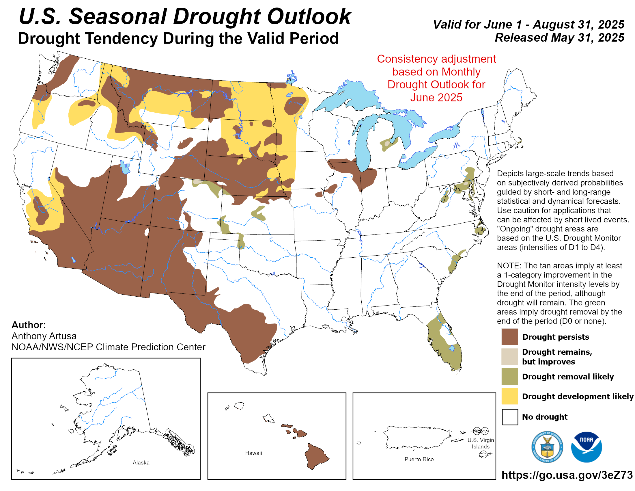
Well, October is half over, and if anything, the drought has persisted and intensified. The greens and tans in Texas should be replaced by browns.
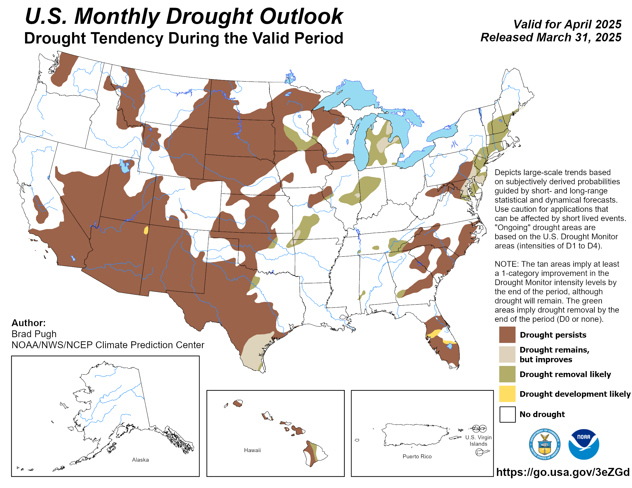
I had no questions or doubts this would improve based on the past Nino climatology. Now, I find myself questioning everything that has been predicted with the current October track record. The below graph was released yesterday.

I had no questions or doubts this would improve based on the past Nino climatology. Now, I find myself questioning everything that has been predicted with the current October track record. The below graph was released yesterday.

0 likes
The preceding post is NOT an official forecast, and should not be used as such. It is only the opinion of the poster and may or may not be backed by sound meteorological data. It is NOT endorsed by any professional institution including storm2k.org. For Official Information please refer to the NHC and NWS products.
One thing we should all have learned this year is that things flip quickly. It has not been a pleasant weather year, everything has been extreme. I'm not sure who said it (Harold Taft?)...but in Texas all droughts end in a flood, as soon as the last flood ends another drought begins..rinse repeat
That being said the next 5 days is dry and seasonal. Hopefully next week's 500mb shuffle changes things. Maybe we can pull a 1972, dry dry October until the final week and ended up above normal
That being said the next 5 days is dry and seasonal. Hopefully next week's 500mb shuffle changes things. Maybe we can pull a 1972, dry dry October until the final week and ended up above normal
0 likes
The above post and any post by Ntxw is NOT an official forecast and should not be used as such. It is just the opinion of the poster and may or may not be backed by sound meteorological data. It is NOT endorsed by any professional institution including Storm2k. For official information, please refer to NWS products.
-
weatherdude1108
- Category 5

- Posts: 4228
- Joined: Tue Dec 13, 2011 1:04 pm
- Location: Northwest Austin/Cedar Park, TX
Interesting little graphic on the smoke plume in this area. I'm in south Cedar Park, but I'll be in bed inside by the time it gets here.
But yeah, like a broken record, the rain can't come soon enough.

But yeah, like a broken record, the rain can't come soon enough.

0 likes
The preceding post is NOT an official forecast, and should not be used as such. It is only the opinion of the poster and may or may not be backed by sound meteorological data. It is NOT endorsed by any professional institution including storm2k.org. For Official Information please refer to the NHC and NWS products.
Re:
weatherdude1108 wrote:Interesting little graphic on the smoke plume in this area. I'm in south Cedar Park, but I'll be in bed inside by the time it gets here.
But yeah, like a broken record, the rain can't come soon enough.
Yea I've been monitoring the smoke because it definitely looks like it's coming right over my area and I have been having itchy eyes the past couple of days and sinus issues. I have a portable filter in my bedroom as well as another fan and the air conditioner on full blast hoping to keep the air inside the house clear.
0 likes
Resident Rain Miser
I am a weather hobbyist living 3.5 miles south of Downtown Austin and in no way or fashion should anything I say concerning forecasts be taken seriously. Please check your local NWS for accurate weather forecasting and conditions.
I am a weather hobbyist living 3.5 miles south of Downtown Austin and in no way or fashion should anything I say concerning forecasts be taken seriously. Please check your local NWS for accurate weather forecasting and conditions.
-
weatherdude1108
- Category 5

- Posts: 4228
- Joined: Tue Dec 13, 2011 1:04 pm
- Location: Northwest Austin/Cedar Park, TX
Re: Re:
JDawg512 wrote:weatherdude1108 wrote:Interesting little graphic on the smoke plume in this area. I'm in south Cedar Park, but I'll be in bed inside by the time it gets here.
But yeah, like a broken record, the rain can't come soon enough.
Yea I've been monitoring the smoke because it definitely looks like it's coming right over my area and I have been having itchy eyes the past couple of days and sinus issues. I have a portable filter in my bedroom as well as another fan and the air conditioner on full blast hoping to keep the air inside the house clear.
Yeah, same here. I have had more chest congestion and crud since this started and didn't walk outside today. I have a couple humidifiers in my room and daughter's with ac running.
0 likes
-
aggiecutter
- Category 5

- Posts: 1755
- Joined: Thu Oct 14, 2004 9:22 pm
- Location: Texarkana
Re: Texas Fall-2015
JB says blow torch will continue through November: Click on Daily Update
http://www.weatherbell.com/fitch/index.php?cmd=homepage
http://www.weatherbell.com/fitch/index.php?cmd=homepage
0 likes
-
aggiecutter
- Category 5

- Posts: 1755
- Joined: Thu Oct 14, 2004 9:22 pm
- Location: Texarkana
Return to “USA & Caribbean Weather”
Who is online
Users browsing this forum: A1A, AnnularCane, Cpv17 and 108 guests


