Spring on the Plains.Ntxw wrote:The extremes today in Texas.
Currently 1 mile visibility in Amarillo with winds gusting 30+ mph and heavy snow, near blizzard
State high of 103F in Alice, Texas
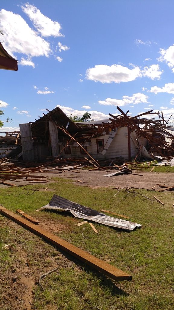
Extensive tornado damage near Canton-Emory line
DFW had a high today of 91F and is now 58F
Texas Spring 2017
Moderator: S2k Moderators
Forum rules

The posts in this forum are NOT official forecast and should not be used as such. They are just the opinion of the poster and may or may not be backed by sound meteorological data. They are NOT endorsed by any professional institution or STORM2K.
-
Ralph's Weather
- S2K Supporter

- Posts: 3371
- Age: 38
- Joined: Fri Dec 13, 2013 11:55 am
- Location: Lindale, TX
- Contact:
Re: Texas Spring 2017
0 likes
Follow on Facebook at Ralph's Weather.
-
Texas Snowman

- Storm2k Moderator

- Posts: 6197
- Joined: Fri Jan 25, 2008 11:29 am
- Location: Denison, Texas
Re: Texas Spring 2017
EF-5bigj wrote:Seeing pictures damage is extreme in some places.
Yup. Looked pretty bad. Praying for those involved.
1 likes
The above post and any post by Texas Snowman is NOT an official forecast and should not be used as such. It is just the opinion of the poster and may or may not be backed by sound meteorological data. It is NOT endorsed by any professional institution including storm2k.org. For official information, please refer to NWS products.
-
1900hurricane

- Category 5

- Posts: 6063
- Age: 34
- Joined: Fri Feb 06, 2015 12:04 pm
- Location: Houston, TX
- Contact:
Re: Texas Spring 2017
0 likes
Contract Meteorologist. TAMU & MSST. Fiercely authentic, one of a kind. We are all given free will, so choose a life meant to be lived. We are the Masters of our own Stories.
Opinions expressed are mine alone.
Follow me on Twitter at @1900hurricane : Read blogs at https://1900hurricane.wordpress.com/
Opinions expressed are mine alone.
Follow me on Twitter at @1900hurricane : Read blogs at https://1900hurricane.wordpress.com/

Re: Texas Spring 2017
Some scattered showers and thunderstorms are coming in from the west/southwest. May get at least a little rain over the next couple of hours but probably less than a quarter inch given the speed and scattered nature.
0 likes
Resident Rain Miser
I am a weather hobbyist living 3.5 miles south of Downtown Austin and in no way or fashion should anything I say concerning forecasts be taken seriously. Please check your local NWS for accurate weather forecasting and conditions.
I am a weather hobbyist living 3.5 miles south of Downtown Austin and in no way or fashion should anything I say concerning forecasts be taken seriously. Please check your local NWS for accurate weather forecasting and conditions.
Re: Texas Spring 2017
We had heavy rain in Round Rock around 7 pm, and some rain at the house. Put the car up in case of hail overnight but I don't think it even rained again. If it did I slept thru it
I think they are going to be analyzing the data from today in N Texas for a while trying to figure out why DFW got nothing and Canton area got hit way ahead of the front
I think they are going to be analyzing the data from today in N Texas for a while trying to figure out why DFW got nothing and Canton area got hit way ahead of the front
0 likes

Re: Texas Spring 2017
Shoshana wrote:We had heavy rain in Round Rock around 7 pm, and some rain at the house. Put the car up in case of hail overnight but I don't think it even rained again. If it did I slept thru it
I think they are going to be analyzing the data from today in N Texas for a while trying to figure out why DFW got nothing and Canton area got hit way ahead of the front
The cap was stronger slightly to the west it seems. It took the impulse kicking out along with the front, which by then was already past DFW. It was a good thing, Van Zandt county is only a couple of counties over from Dallas, had that thing grew an hour or two before, you might have seen it come up Ellis, Dallas, and Collin counties in a worse case scenario with the same track lots of people.
Link: https://youtu.be/QhM3akdq6q0
I would be surprised if this was rated anything less than EF4
2 likes
The above post and any post by Ntxw is NOT an official forecast and should not be used as such. It is just the opinion of the poster and may or may not be backed by sound meteorological data. It is NOT endorsed by any professional institution including Storm2k. For official information, please refer to NWS products.
Help support Storm2K!
Re: Texas Spring 2017
Agreed, if it had started up a few counties west it would have been much much worse than it was.
And after I posted earthier, we got more rain and some thunder
And after I posted earthier, we got more rain and some thunder
0 likes
-
Portastorm

- Storm2k Moderator
- Posts: 9955
- Age: 63
- Joined: Fri Jul 11, 2003 9:16 am
- Location: Round Rock, TX
- Contact:
Re: Texas Spring 2017
JDawg512 wrote:Some scattered showers and thunderstorms are coming in from the west/southwest. May get at least a little rain over the next couple of hours but probably less than a quarter inch given the speed and scattered nature.
Well, mea culpa JDawg .. you were right. Despite the models on Friday showing some rainfall in our area for yesterday ... it was scattered at best. Here just NW of Sunset Valley we got doodly-squat in the rain bucket at the Portastorm Weather Center. Dang it!
0 likes
Any forecasts under my name are to be taken with a grain of salt. Get your best forecasts from the National Weather Service and National Hurricane Center.
-
weatherdude1108
- Category 5
- Posts: 4228
- Joined: Tue Dec 13, 2011 1:04 pm
- Location: Northwest Austin/Cedar Park, TX
Re: Texas Spring 2017
Got periodic passing storms early this morning. Zero measurable rain. But, woke up to 52 degrees! 


1 likes
The preceding post is NOT an official forecast, and should not be used as such. It is only the opinion of the poster and may or may not be backed by sound meteorological data. It is NOT endorsed by any professional institution including storm2k.org. For Official Information please refer to the NHC and NWS products.
-
bubba hotep

- S2K Supporter
- Posts: 6014
- Joined: Wed Dec 28, 2016 1:00 am
- Location: Collin County Texas
Re: Texas Spring 2017
Wow...

0 likes
Winter time post are almost exclusively focused on the DFW area.

Re: Texas Spring 2017
TWC had a few fly overs of damage I believe I saw bare foundations  but the destruction was so bad it was hard to tell
0 likes
Re: Texas Spring 2017
No word yet of rating

0 likes
The above post and any post by Ntxw is NOT an official forecast and should not be used as such. It is just the opinion of the poster and may or may not be backed by sound meteorological data. It is NOT endorsed by any professional institution including Storm2k. For official information, please refer to NWS products.
Help support Storm2K!
Help support Storm2K!
-
Texas Snowman
- Storm2k Moderator
- Posts: 6197
- Joined: Fri Jan 25, 2008 11:29 am
- Location: Denison, Texas
Re: Texas Spring 2017
@NWSFortWorth - At least 4 confirmed tornadoes. Two EF-3 and two EF-0. All ratings are preliminary. Surveys will continue tomorrow. #txwx #etxwx
0 likes
The above post and any post by Texas Snowman is NOT an official forecast and should not be used as such. It is just the opinion of the poster and may or may not be backed by sound meteorological data. It is NOT endorsed by any professional institution including storm2k.org. For official information, please refer to NWS products.
-
aggiecutter
- Category 5
- Posts: 1755
- Joined: Thu Oct 14, 2004 9:22 pm
- Location: Texarkana
Re: Texas Spring 2017
Two EF-3 Tornadoes within rock throwing distance of each other, fascinating:


0 likes
-
Ralph's Weather
- S2K Supporter
- Posts: 3371
- Age: 38
- Joined: Fri Dec 13, 2013 11:55 am
- Location: Lindale, TX
- Contact:
Re: Texas Spring 2017
While visiting my family this evening my dad took us over to see some possible tornado damage on the adjacent ranch to my family's. Most of a mature pecan grove is leveled and one barn destroyed along with roof damage to another. Power lines are on the ground. That was as far as we could go as there were too many trees down to go further. Reports were that the damage extended further west from there. This was all with the tornado warned storm in northern Smith Co. They were on their porch watching and luckily it seems to have lifted just before crossing the county road .
1 likes
Follow on Facebook at Ralph's Weather.
-
Ralph's Weather
- S2K Supporter
- Posts: 3371
- Age: 38
- Joined: Fri Dec 13, 2013 11:55 am
- Location: Lindale, TX
- Contact:
Re: Texas Spring 2017
Damage in Smith County.
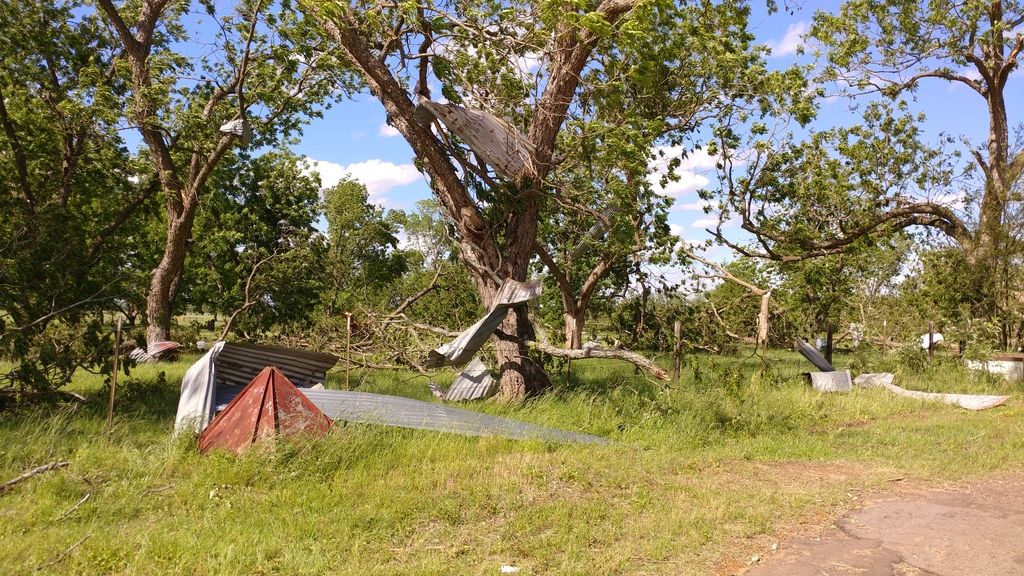
I wish I got a pic of the pecan grove with just about every tree uprooted.


I wish I got a pic of the pecan grove with just about every tree uprooted.
1 likes
Follow on Facebook at Ralph's Weather.
-
Yukon Cornelius
- S2K Supporter
- Posts: 1842
- Age: 42
- Joined: Thu Dec 20, 2012 9:23 pm
- Location: Dean, TX/Westcliffe, CO
Re: Texas Spring 2017
After another rain forecast bust, once again, at least we received some really nice cool weather. Woke up this morning to a low of 38. It would be nice to actually have a thunderstorm or rainfall forecast verify. The last 4 "guaranteed" events for us haven't produced even a single drop of rain. "Make Texas Wet Again".
0 likes
#neversummer
-
Ralph's Weather
- S2K Supporter
- Posts: 3371
- Age: 38
- Joined: Fri Dec 13, 2013 11:55 am
- Location: Lindale, TX
- Contact:
Re: Texas Spring 2017
Yukon Cornelius wrote:After another rain forecast bust, once again, at least we received some really nice cool weather. Woke up this morning to a low of 38. It would be nice to actually have a thunderstorm or rainfall forecast verify. The last 4 "guaranteed" events for us haven't produced even a single drop of rain. "Make Texas Wet Again".
Made 45 out here in East Texas. Nice start to May.
0 likes
Follow on Facebook at Ralph's Weather.
-
Tireman4

- S2K Supporter
- Posts: 5903
- Age: 60
- Joined: Fri Jun 30, 2006 1:08 pm
- Location: Humble, Texas
- Contact:
Re: Texas Spring 2017
00
FXUS64 KHGX 011434
AFDHGX
Area Forecast Discussion
National Weather Service Houston/Galveston TX
934 AM CDT Mon May 1 2017
.UPDATE...
Surface observations show that we got just a little bit chillier
than forecast overnight, but also that temperatures have rebounded
very quickly after sunrise, and so the forecast of temperatures
in the lower to middle 80s under sunny skies looks on track. Made
cosmetic tweaks to temperature and dewpoint to better match
trends this morning.
&&
.PREV DISCUSSION... /ISSUED 607 AM CDT Mon May 1 2017/
AVIATION...
VFR conditions expected. Winds will pick up later this morning and
this afternoon as the surface high moves off the coast.
40
PREV DISCUSSION... /ISSUED 317 AM CDT Mon May 1 2017/
DISCUSSION...
Weak high pressure just off the Texas coast will continue to drift
slowly east today. Light west to southwest winds this morning will
gradually increase and become SSE this evening. The high will
bring sunny skies today. The dry air in place should allow for a
large diurnal range in temps today and a 30 degree range looks
possible. A return of low level moisture should keep min temps
tonight a bit warmer. 850 temps warm on Tuesday and high temps on
Tuesday should warm into the upper 80s. Fcst soundings not showing
much in the way of cloud cover to hinder the temperature rise.
Tuesday night gets a bit more interesting. A weak upper level
disturbance will approach SE TX after 06z. Moisture return really
gets going around 09z and fcst soundings show PW values climbing
to 1.90 inches by 12z. Instability also increases and SE TX will
lie in a weak 70 kt RRQ. Still expecting elevated convection to
develop in the warm air advection regime. Mid level lapse rates
are steep so would expect some of the stronger storms to produce
hail. Bumped PoPs upward for coastal regions late Tuesday night.
The storms will continue for part of the morning before ending as
the disturbance pushes east. Think there will be a break late
Wednesday morning through the early afternoon before another
upper level disturbance and a surface cold front approaches. Fcst
soundings show clouds eroding for a time in the early afternoon
with a bit of heating helping to destabilize things ahead of the
front. Fcst soundings show CAPE values 4000, PW values near 1.90
inches, LI`s around -11 and lapse rates remain steep. NAM fcst
soundings show a weak capping inversion in the 850-700 layer while
the GFS shows no capping in place. At this time, feel the front,
the second disturbance coupled with a weak splitting jet structure
and a strengthening RRQ will foster a second round of convection
that will move through SE TX late Wed afternoon or evening. This
area of convection will have the potential to produce damaging
winds. The ECMWF and GFS are on the same page with things
including the timing which has conditions clearing out after 06z
Thursday. Will hold onto PoPs for a bit longer (into Thurs AM)
because the Canadian model is slower and this model has been
rather consistent with timing.
The upper trough moves east on Thursday and SE TX will lie in a
dry northwest flow as ridging tries to amplify over Texas. Dry
conditions expected through next weekend with mild spring
temperatures through Friday and a gentle warm up next weekend. 43
MARINE...
Onshore winds will return later today and tonight as high pressure
moves overhead and east of the area. Moderate to strong onshore
winds are expected Tuesday night and Wednesday as the surface
pressure gradient tightens over the area. Conditions may approach
advisory levels late Tuesday night into Wednesday. A cold front is
expected to make its way off of the coast Wednesday night or early
Thursday morning.
A few marine impacts are possible with the mid week event:
- Long-period swells will help contribute to higher than normal tide
levels. Water levels are forecast to be highest during the time of
high tide Wednesday morning. These could approach 1 foot above
normal.
- Isolated strong to severe storms are possible Tuesday night and
Wednesday morning, and then again Wednesday night ahead of
the front.
- A small craft advisory is likely following the frontal passage
Wednesday night and Thursday.
40
&&
.PRELIMINARY POINT TEMPS/POPS...
College Station (CLL) 84 58 89 66 82 / 0 0 0 50 80
Houston (IAH) 86 62 88 69 82 / 0 0 0 50 80
Galveston (GLS) 81 73 84 75 80 / 0 0 0 60 80
&&
.HGX WATCHES/WARNINGS/ADVISORIES...
TX...NONE.
GM...NONE.
&&
$$
Discussion...25
0 likes
Re: Texas Spring 2017
The entire month of April was disappointing for me. So what does May (our wettest month on average) have in store? Well not a whole lot at least for the next 10 days.
On a side note April seemed extremely windy as far as April's go. Had many frequent windy periods. When I think of windy months I think of March especially growing up.
On a side note April seemed extremely windy as far as April's go. Had many frequent windy periods. When I think of windy months I think of March especially growing up.
Last edited by JDawg512 on Mon May 01, 2017 12:53 pm, edited 1 time in total.
0 likes
Resident Rain Miser
I am a weather hobbyist living 3.5 miles south of Downtown Austin and in no way or fashion should anything I say concerning forecasts be taken seriously. Please check your local NWS for accurate weather forecasting and conditions.
I am a weather hobbyist living 3.5 miles south of Downtown Austin and in no way or fashion should anything I say concerning forecasts be taken seriously. Please check your local NWS for accurate weather forecasting and conditions.
Return to “USA & Caribbean Weather”
Who is online
Users browsing this forum: Cpv17, Iceresistance and 140 guests