Texas Spring-2014

U.S. & Caribbean Weather Discussions and Severe Weather Events

Moderator: S2k Moderators

Forum rules

The posts in this forum are NOT official forecast and should not be used as such. They are just the opinion of the poster and may or may not be backed by sound meteorological data. They are NOT endorsed by any professional institution or STORM2K.

Help Support Storm2K
Message
Author
User avatar
gboudx
S2K Supporter
S2K Supporter
Posts: 4080
Joined: Thu Sep 04, 2003 1:39 pm
Location: Rockwall, Tx but from Harvey, La

#861 Postby gboudx » Mon May 12, 2014 8:13 pm

Steve McCauley says another round of widespread rain tomorrow evening/night.

A broad area of rain with embedded heavy thunderstorms continues across the eastern and southern portions of north Texas moving to the NE. Rainfall amounts so far in the Metroplex range from a low 0.20" in NE Tarrant County to numerous locations of 1 to 2 inches. Somewhat surprisingly, the heaviest rainfall has been between Stephenville and Granbury where 3 to 5 inches is estimated to have fallen!

This is round #1 of the widespread rain. Another broad area of rain will move in late in the day Tuesday into Tuesday night supplying an additional 0.25" to 0.50" by Wednesday morning.

The sun will return on Wednesday but temepratures stay below normal until the weekend.


Nice moderate to heavy rain ongoing over the Lavon and Ray Hubbard watersheds.
0 likes   

User avatar
ravyrn
S2K Supporter
S2K Supporter
Posts: 1000
Age: 42
Joined: Sun Aug 31, 2008 5:10 am
Location: Alderbranch, TX

Re:

#862 Postby ravyrn » Mon May 12, 2014 8:23 pm

gboudx wrote:Nice moderate to heavy rain ongoing over the Lavon and Ray Hubbard watersheds.


Yeah, hopefully they can gain some capacity from these rains. It really sucks that the bands of heaviest rainfall are always about 50 miles east of the reservoirs that need them the most such as the DFW area and Highland Lakes. I can hardly bring myself to mention some of the reservoirs in West Texas and the panhandle. I'd love (and hate) to see a picture of how bad their reservoirs out there are looking. We don't have many posters from out that way, but I know a lot of their reservoirs are basically empty. I'd be interested to know what communities that depended on these reservoirs are turning to for their water supplies.
0 likes   

User avatar
Rgv20
S2K Supporter
S2K Supporter
Posts: 2466
Age: 38
Joined: Wed Jan 05, 2011 5:42 pm
Location: Edinburg/McAllen Tx

#863 Postby Rgv20 » Mon May 12, 2014 8:23 pm

SPC latest discussion concerning Severe weather..

DAY 1 CONVECTIVE OUTLOOK
NWS STORM PREDICTION CENTER NORMAN OK
0753 PM CDT MON MAY 12 2014

VALID 130100Z - 131200Z

...CENTRAL AND SOUTH TX...
SEVERAL INTENSE THUNDERSTORMS ARE AFFECTING NORTHERN MEXICO JUST
SOUTH OF THE RIO GRANDE. OTHER STORMS ALONG THE TAIL END OF THE
AFOREMENTIONED CONVECTIVE LINE ARE SAGGING SOUTHWARD TOWARD THE SAT
AREA. VARIOUS MODEL SOLUTIONS SUGGEST THIS REGION WILL SEE
CONTINUED STRONG TO SEVERE THUNDERSTORM ACTIVITY OVERNIGHT AS STORMS
CONGEAL AND SPREAD EASTWARD. LARGE HAIL AND DAMAGING WINDS WILL BE
POSSIBLE IN THE STRONGEST CELLS. REFER TO MESOSCALE DISCUSSION 589
FOR FURTHER SHORT-TERM DETAILS.


EDIT: Just had a Thunder Shower with some moderate rain....The Dew Point is 77!
0 likes   
The following post is NOT an official forecast and should not be used as such. It is just the opinion of the poster and may or may not be backed by sound meteorological data. It is NOT endorsed by any professional institution including storm2k.org For Official Information please refer to the NHC and NWS products.

User avatar
ravyrn
S2K Supporter
S2K Supporter
Posts: 1000
Age: 42
Joined: Sun Aug 31, 2008 5:10 am
Location: Alderbranch, TX

Re: Texas Spring-2014

#864 Postby ravyrn » Mon May 12, 2014 8:32 pm

Anyone knowledgeable mind explaining what sets this event aside from the rest. It's been so long, I can hardly recall having so much rain on the west side of a front after the squall line moved through. What factors contributed to give us the heavy rain on the squall, as well as the post-frontal rain.
0 likes   

User avatar
South Texas Storms
Professional-Met
Professional-Met
Posts: 4224
Joined: Thu Jun 24, 2010 12:28 am
Location: Houston, TX

Re: Texas Spring-2014

#865 Postby South Texas Storms » Mon May 12, 2014 8:36 pm

Flash flood risk is increasing across the Texas Hill Country and surrounding areas.

Image

Uploaded with ImageShack.us
0 likes   

weatherdude1108
Category 5
Category 5
Posts: 4228
Joined: Tue Dec 13, 2011 1:04 pm
Location: Northwest Austin/Cedar Park, TX

#866 Postby weatherdude1108 » Mon May 12, 2014 8:46 pm

Heavy rain just started here with thunder and lightning at the Weatherdude Center.
0 likes   

User avatar
TeamPlayersBlue
Category 5
Category 5
Posts: 3445
Joined: Tue Feb 02, 2010 1:44 am
Location: Denver/Applewood, CO

#867 Postby TeamPlayersBlue » Mon May 12, 2014 8:51 pm

This is the kind of event that we have been looking for. Excited for it, let it rain! Travis and lakes west of Austin should get a real dumping. I think we will still have a flood situation is some areas though unfortunately.
0 likes   
Personal Forecast Disclaimer:
The posts in this forum are NOT official forecast and should not be used as such. They are just the opinion of the poster and may or may not be backed by sound meteorological data. They are NOT endorsed by any professional institution or storm2k.org. For official information, please refer to the NHC and NWS products.

User avatar
gboudx
S2K Supporter
S2K Supporter
Posts: 4080
Joined: Thu Sep 04, 2003 1:39 pm
Location: Rockwall, Tx but from Harvey, La

Re: Texas Spring-2014

#868 Postby gboudx » Mon May 12, 2014 9:06 pm

ravyrn wrote:Anyone knowledgeable mind explaining what sets this event aside from the rest. It's been so long, I can hardly recall having so much rain on the west side of a front after the squall line moved through. What factors contributed to give us the heavy rain on the squall, as well as the post-frontal rain.


DFW NWS had mentioned in a discussion this would be an overrunning precip event. So warm, moist gulf air moving over the frontal boundary. This is the limit of my knowledge on overrunning events. :D
0 likes   

User avatar
Tsquare
Tropical Wave
Tropical Wave
Posts: 7
Joined: Sun Aug 28, 2011 12:54 pm
Location: Georgetown, Tx

Re: Texas Spring-2014

#869 Postby Tsquare » Mon May 12, 2014 9:19 pm

WOW!! Rural, northwest of Georgetown. The rain is coming down! What a wonderful thing.
0 likes   

Shoshana
Category 5
Category 5
Posts: 1414
Joined: Thu Sep 09, 2004 7:50 pm
Location: NE Austin

Re: Texas Spring-2014

#870 Postby Shoshana » Mon May 12, 2014 9:28 pm

Just started raining pretty hard near P'ville. Need it!!
0 likes   

User avatar
ravyrn
S2K Supporter
S2K Supporter
Posts: 1000
Age: 42
Joined: Sun Aug 31, 2008 5:10 am
Location: Alderbranch, TX

Re: Texas Spring-2014

#871 Postby ravyrn » Mon May 12, 2014 9:55 pm

gboudx wrote:DFW NWS had mentioned in a discussion this would be an overrunning precip event. So warm, moist gulf air moving over the frontal boundary. This is the limit of my knowledge on overrunning events. :D


I figured it had a role in it. Thanks!
0 likes   

User avatar
wxman57
Moderator-Pro Met
Moderator-Pro Met
Posts: 22978
Age: 67
Joined: Sat Jun 21, 2003 8:06 pm
Location: Houston, TX (southwest)

Re: Texas Spring-2014

#872 Postby wxman57 » Mon May 12, 2014 9:59 pm

Portastorm should be getting a good bit of rain in Austin tonight. Quite a line of storms across Texas. I'm in Miami until tomorrow evening, meeting with potential clients. I figure my evening flight to Houston will be delayed or re-routed. Houston only gets squalls when I'm trying to land there.
0 likes   

User avatar
Ntxw
Storm2k Moderator
Storm2k Moderator
Posts: 22784
Joined: Wed Oct 21, 2009 6:34 pm
Location: DFW, Texas

Re: Texas Spring-2014

#873 Postby Ntxw » Mon May 12, 2014 10:03 pm

wxman57 wrote:Portastorm should be getting a good bit of rain in Austin tonight. Quite a line of storms across Texas. I'm in Miami until tomorrow evening, meeting with potential clients. I figure my evening flight to Houston will be delayed or re-routed. Houston only gets squalls when I'm trying to land there.


Maybe it can keep you in Miami a little longer, say a few days. I mean, you wouldn't want to come back to these bone chilling cold temperatures in Houston. 70s, brrrr for your standards in May.
0 likes   
The above post and any post by Ntxw is NOT an official forecast and should not be used as such. It is just the opinion of the poster and may or may not be backed by sound meteorological data. It is NOT endorsed by any professional institution including Storm2k. For official information, please refer to NWS products.

  Help support Storm2K!
Help Support Storm2K

User avatar
Rgv20
S2K Supporter
S2K Supporter
Posts: 2466
Age: 38
Joined: Wed Jan 05, 2011 5:42 pm
Location: Edinburg/McAllen Tx

#874 Postby Rgv20 » Mon May 12, 2014 10:15 pm

Image

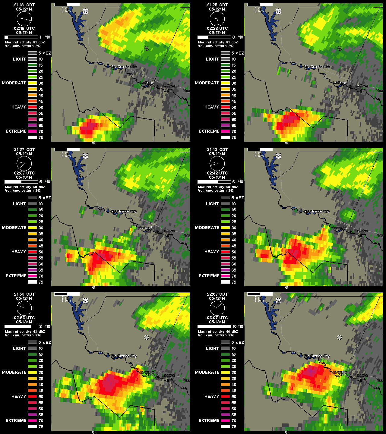
Severe Thunderstorm Warning

SEVERE THUNDERSTORM WARNING
TXC427-130345-
/O.NEW.KBRO.SV.W.0012.140513T0300Z-140513T0345Z/

BULLETIN - EAS ACTIVATION REQUESTED
SEVERE THUNDERSTORM WARNING
NATIONAL WEATHER SERVICE BROWNSVILLE TX
1000 PM CDT MON MAY 12 2014

THE NATIONAL WEATHER SERVICE IN BROWNSVILLE HAS ISSUED A

* SEVERE THUNDERSTORM WARNING FOR...
SOUTHERN STARR COUNTY IN DEEP SOUTH TEXAS.

* UNTIL 1045 PM CDT

* AT 1001 PM CDT...NATIONAL WEATHER SERVICE METEOROLOGISTS DETECTED A
SEVERE THUNDERSTORM...CAPABLE OF PRODUCING QUARTER SIZE HAIL AND
DAMAGING 60 MPH WINDS...10 MILES SOUTHWEST OF RIO GRANDE CITY...
MOVING NORTHEAST AT 30 MPH.

* LOCATIONS IN THE WARNING INCLUDE...
LOS GARZAS.
LOS ALVAREZ.
RIO GRANDE CITY.
LA VICTORIA.
EL SAUZ.
HIGHWAY 83.

PRECAUTIONARY/PREPAREDNESS ACTIONS...

SEVERE THUNDERSTORMS CAN PRODUCE WIND SPEEDS STRONG ENOUGH TO BRING
DOWN TREES AND POWER LINES AND DAMAGE OR DESTROY MOBILE HOMES AND
OUTBUILDINGS. PERSONS OUTDOORS OR IN VEHICLES SHOULD SEEK SAFETY
INSIDE A STURDY BUILDING UNTIL THE STORM PASSES. IF YOU CAN HEAR
THUNDER...YOU ARE CLOSE ENOUGH TO BE STRUCK BY LIGHTNING.

PLEASE REPORT TORNADOES OR FUNNEL CLOUDS...WINDS OF 58 MPH OR
HIGHER...HAIL THE SIZE OF PENNIES OR LARGER...AND ANY WIND DAMAGE TO
YOUR NATIONAL WEATHER SERVICE IN BROWNSVILLE BY CALLING 956-504-1432.

&&

LAT...LON 2660 9887 2643 9854 2624 9868 2626 9869
2627 9873 2629 9873 2629 9875 2630 9876
2631 9875 2632 9878 2636 9880 2635 9890
2638 9893 2636 9895 2638 9896
TIME...MOT...LOC 0301Z 207DEG 26KT 2627 9890

$$

JGG
0 likes   
The following post is NOT an official forecast and should not be used as such. It is just the opinion of the poster and may or may not be backed by sound meteorological data. It is NOT endorsed by any professional institution including storm2k.org For Official Information please refer to the NHC and NWS products.

aggiecutter
Category 5
Category 5
Posts: 1753
Joined: Thu Oct 14, 2004 9:22 pm
Location: Texarkana

#875 Postby aggiecutter » Mon May 12, 2014 10:30 pm

When is the last time this happened:

FLASH FLOOD WARNING
TXC453-130615-
/O.NEW.KEWX.FF.W.0003.140513T0317Z-140513T0615Z/
/00000.0.ER.000000T0000Z.000000T0000Z.000000T0000Z.OO/

BULLETIN - EAS ACTIVATION REQUESTED
FLASH FLOOD WARNING
NATIONAL WEATHER SERVICE AUSTIN/SAN ANTONIO TX
1017 PM CDT MON MAY 12 2014

THE NATIONAL WEATHER SERVICE IN AUSTIN SAN ANTONIO HAS ISSUED A

* FLASH FLOOD WARNING FOR...
TRAVIS COUNTY IN SOUTH CENTRAL TEXAS...
THIS INCLUDES THE CITIES OF...AUSTIN BERGSTROM INTERNATIONAL
AIRPORT...TANGLEWOOD FOREST...AUSTIN...

* UNTIL 115 AM CDT

* AT 1012 PM CDT...NATIONAL WEATHER SERVICE DOPPLER RADAR
INDICATED HEAVY RAINFALL CAPABLE OF PRODUCING FLASH FLOODING
FROM THUNDERSTORMS ACROSS THE AUSTIN METRO AREA. THESE
THUNDERSTORMS WERE NEARLY STATIONARY.

* LOCATIONS IN THE WARNING INCLUDE BUT ARE NOT LIMITED TO WEST LAKE
HILLS...ROLLINGWOOD...MANSFIELD DAM...LAKEWAY...LAGO VISTA AND BEE
CAVE.
0 likes   

User avatar
South Texas Storms
Professional-Met
Professional-Met
Posts: 4224
Joined: Thu Jun 24, 2010 12:28 am
Location: Houston, TX

Re: Texas Spring-2014

#876 Postby South Texas Storms » Mon May 12, 2014 10:47 pm

Heavy rain and thunderstorms are currently moving through the Austin and San Antonio areas. It's so nice to see beneficial rain across much of the region!

Image

Uploaded with ImageShack.us
0 likes   

weatherdude1108
Category 5
Category 5
Posts: 4228
Joined: Tue Dec 13, 2011 1:04 pm
Location: Northwest Austin/Cedar Park, TX

#877 Postby weatherdude1108 » Mon May 12, 2014 10:47 pm

Raining heavily off and on. Last wave I think just started. 1.5 inches so far. My e-gauge decided to go on the fritz before this event, so using graduated gauge. Had 1.5 inches in it a half hour ago when I went out between storms in my waterproof boots. That is in about 1.5 hours time off and on. Not excessive. I emptied it so more could be added in case we get more than 6 inches (limit of gauge). But my backyard is lake right now. Some of my natives and adapted plants I planted a couple months ago are underwater.
0 likes   

weatherdude1108
Category 5
Category 5
Posts: 4228
Joined: Tue Dec 13, 2011 1:04 pm
Location: Northwest Austin/Cedar Park, TX

Re: Texas Spring-2014

#878 Postby weatherdude1108 » Mon May 12, 2014 10:49 pm

South Texas Storms wrote:Heavy rain and thunderstorms are currently moving through the Austin and San Antonio areas. It's so nice to see beneficial rain across much of the region!

Image

Uploaded with ImageShack.us


It is beautiful! Not so hard that it completely runs off either. Good soaking frog quenching rain!! :D
0 likes   
The preceding post is NOT an official forecast, and should not be used as such. It is only the opinion of the poster and may or may not be backed by sound meteorological data. It is NOT endorsed by any professional institution including storm2k.org. For Official Information please refer to the NHC and NWS products.

weatherdude1108
Category 5
Category 5
Posts: 4228
Joined: Tue Dec 13, 2011 1:04 pm
Location: Northwest Austin/Cedar Park, TX

#879 Postby weatherdude1108 » Tue May 13, 2014 6:56 am

3.7 inches out of this rain event at the Weatherdude Center. Add 0.9 from last Thursday night. Total of 4.6 inches on my yard in less than a week! :lightning: :rain: :D

Nice refreshing cool breeze this morning! :flag: :cold: :)

Nice change from the warm, dry, windy days recently that suck the water out of everything. :)
0 likes   

User avatar
TeamPlayersBlue
Category 5
Category 5
Posts: 3445
Joined: Tue Feb 02, 2010 1:44 am
Location: Denver/Applewood, CO

#880 Postby TeamPlayersBlue » Tue May 13, 2014 8:12 am

2.40 inches of rain last night here in Sugar Land. Solid rain. Heard they got about two inches at Lake Travis. Its a start
0 likes   
Personal Forecast Disclaimer:
The posts in this forum are NOT official forecast and should not be used as such. They are just the opinion of the poster and may or may not be backed by sound meteorological data. They are NOT endorsed by any professional institution or storm2k.org. For official information, please refer to the NHC and NWS products.


Return to “USA & Caribbean Weather”

Who is online

Users browsing this forum: Stratton23 and 7 guests