Slow moving and training storms over the Sabine River Valley are back building to the west early this afternoon. Radar estimates indicate rainfall totals of 6-8 inches with as much as 10 inches has fallen in the last few hours just east of Winnie.
These storms will continue to build westward this afternoon into an unstable air mass over SE TX, while another line of storms near Austin approaches from the WNW. Given excessive rainfall rates of 2-4 inches per hour, flash flooding will be possible this afternoon over portions of SE TX. It is unclear how far west the storms will build, but it appears that some more organized activity will reach toward the I-45 corridor and eastward.
Texas Spring 2021
Moderator: S2k Moderators
Forum rules

The posts in this forum are NOT official forecast and should not be used as such. They are just the opinion of the poster and may or may not be backed by sound meteorological data. They are NOT endorsed by any professional institution or STORM2K.
-
jasons2k

- Storm2k Executive

- Posts: 8290
- Age: 52
- Joined: Wed Jul 06, 2005 12:32 pm
- Location: The Woodlands, TX
Re: Texas Spring 2021
From Jeff Lindner:
0 likes
-
jasons2k
- Storm2k Executive
- Posts: 8290
- Age: 52
- Joined: Wed Jul 06, 2005 12:32 pm
- Location: The Woodlands, TX
Re: Texas Spring 2021
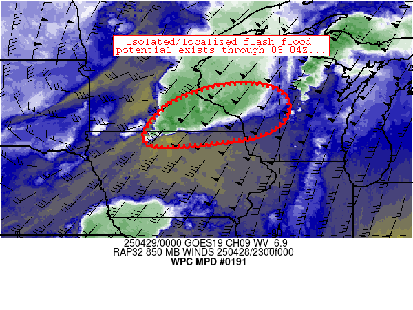
Mesoscale Precipitation Discussion 0191
NWS Weather Prediction Center College Park MD
1240 PM EDT Mon May 17 2021
Areas affected...Far Southeast TX...Far Southwest LA
Concerning...Heavy rainfall...Flash flooding likely
Valid 171636Z - 172300Z
Summary...Areas of flash flooding will be likely through the
afternoon across portions of far southeast Texas and southwest
Louisiana. Highly efficient hourly rainfall rates of 2-3" will
allow for additional localized accumulations of 3-6 inches.
Discussion...Flash flooding is currently ongoing midday across
portions of the Sabine River basin, including across the Beaumont
metropolitan area. A nearly stationary area of surface moisture
convergence has allowed for periodic episodes of deep convection,
producing large swaths of 4-8 inches of precipitation over the
past 6 hours (per MRMS QPE products). These radar estimations
appear to be reasonably accurate with little indication of hail
contamination via analysis of dual-pol radar components. The
Beaumont/Port Arthur Regional Airport (KBPT) measured nearly 7
inches of rain in the past 6 hours, which corroborates MRMS
dual-pol driven radar estimates. The latest radar trends and
hi-res CAM guidance suggest that episodes of heavy precipitation
will continue over this region over the next several hours,
propagating westward toward the Houston metro along with an
approaching, and potentially stalling, outflow boundary from North
Texas.
The aforementioned eastern portions of the outlined area (from
Lake Charles to Beaumont) will continue to see flash flooding with
a large area of 3-hr FFG values of 2 inches or less. Further west
where new convection propagates (from the Houston metro westward),
FFG ranges from 3-5 inches. Deep convection will continue to be
capable of 2-3" per hour rainfall rates, supporting localized FFG
exceedance in only a couple hours where convection is able to
repeat/train. Some training of convection does appear likely, as
an outflow boundary from North TX gradually stalls out over the
outlined area, providing a focal point for new convective
initiation amid a rapidly destabilizing air mass (SB CAPE rising
to 3000-4000 J/kg).
0 likes

Re: Texas Spring 2021
Just noticed that Brett Adair is in Sweetwater, I'm sure many other spotters are out west as well.
0 likes
The above post and any post by dhweather is NOT an official forecast and should not be used as such. It is just the opinion of the poster and may or may not be backed by sound meteorological data. It is NOT endorsed by any professional institution including storm2k.org. For official information, please refer to NWS products.
-
jasons2k
- Storm2k Executive
- Posts: 8290
- Age: 52
- Joined: Wed Jul 06, 2005 12:32 pm
- Location: The Woodlands, TX
Re: Texas Spring 2021
Flash Flood Watch
Flood Watch
National Weather Service Houston/Galveston TX
141 PM CDT Mon May 17 2021
.A slow moving upper level trough of low pressure will bring periods
of showers and thunderstorms to the region through the end of the
week.
TXZ163-164-176>179-195>200-210>214-226-227-235>238-300-313-335>338-
436>439-180645-
/O.NEW.KHGX.FF.A.0004.210517T1841Z-210520T1200Z/
/00000.0.ER.000000T0000Z.000000T0000Z.000000T0000Z.OO/
Houston-Trinity-Madison-Walker-San Jacinto-Polk-Burleson-Brazos-
Washington-Grimes-Montgomery-Northern Liberty-Colorado-Austin-Waller-
Inland Harris-Chambers-Wharton-Fort Bend-Inland Jackson-Inland
Matagorda-Inland Brazoria-Inland Galveston-Southern Liberty-Coastal
Harris-Coastal Jackson-Coastal Matagorda-Coastal Brazoria-Coastal
Galveston-Matagorda Islands-Brazoria Islands-Galveston Island-
Bolivar Peninsula-
Including the cities of Brookshire, Pearland, Caldwell, Stowell,
Liberty, The Woodlands, Dickinson, Devers, Anahuac, Coldspring,
Bellville, Bay City, Trinity, Shepherd, Columbus, Sugar Land,
College Station, Surfside Beach, Hempstead, Dayton, Huntsville,
Baytown, Crockett, Wharton, Conroe, Missouri City, Pecan Grove,
Palacios, League City, La Marque, Bryan, Lake Jackson, Mont Belvieu,
Old River-Winfree, Pasadena, Freeport, First Colony, Clute,
Navasota, Livingston, Texas City, Brenham, Waller, Eagle Lake,
Galveston, Houston, Prairie View, Groveton, Sealy, Rosenberg,
Friendswood, Winnie, Alvin, Ganado, Corrigan, El Campo, Mission
Bend, Edna, Cleveland, Angleton, Somerville, Weimar, and Madisonville
141 PM CDT Mon May 17 2021
...FLASH FLOOD WATCH IN EFFECT THROUGH THURSDAY MORNING...
The National Weather Service in League City has issued a
* Flash Flood Watch for portions of south central Texas and
southeast Texas, including the following areas, in south central
Texas, Coastal Jackson and Inland Jackson. In southeast Texas,
Austin, Bolivar Peninsula, Brazoria Islands, Brazos, Burleson,
Chambers, Coastal Brazoria, Coastal Galveston, Coastal Harris,
Coastal Matagorda, Colorado, Fort Bend, Galveston Island, Grimes,
Houston, Inland Brazoria, Inland Galveston, Inland Harris, Inland
Matagorda, Madison, Matagorda Islands, Montgomery, Northern
Liberty, Polk, San Jacinto, Southern Liberty, Trinity, Walker,
Waller, Washington and Wharton.
* Through Thursday morning
* Heavy rain will focus on a slow moving outflow boundary this
afternoon into this evening and produce 1 to 3 inches of rain with
locally higher amounts possible. An upper level disturbance will
bring additional showers and thunderstorms on Tuesday with another
1 to 3 inches of rain with again locally higher totals. A stronger
upper level disturbance will bring yet another round of heavy rain
Wednesday into Thursday with additional rainfall totals of 2 to 4
inches of rain with again locally higher totals possible. Storm
total rainfall by Thursday morning will average between 4 and 8
inches with isolated totals possibly exceeding ten inches. The
flood threat will be strongly dependent on where the rain falls
and how quickly it falls.
PRECAUTIONARY/PREPAREDNESS ACTIONS...
A Flash Flood Watch means that conditions may develop that lead to
Flash Flooding. Flash Flooding is a very dangerous situation. You
should monitor later forecasts and be prepared to take action should
Flash Flood Warnings be issued.
0 likes
-
captainbarbossa19

- Professional-Met

- Posts: 1094
- Age: 27
- Joined: Wed Aug 21, 2019 11:09 pm
- Location: Beaumont, TX
Re: Texas Spring 2021
Absolutely torrential rains with the system in my area. The drought is completely over now after receiving about 10 inches of rain. Some areas to my east have had almost double. This is really bad considering there are several days of rain left to go.
0 likes
-
captainbarbossa19
- Professional-Met
- Posts: 1094
- Age: 27
- Joined: Wed Aug 21, 2019 11:09 pm
- Location: Beaumont, TX
Re: Texas Spring 2021
Cpv17 wrote:captainbarbossa19 wrote:Iceresistance wrote:ANOTHER Slight risk for Heavy Rain in the Southern Plains next week . . .
https://s3.gifyu.com/images/precip_probhazards_d8_14_contours87d27f495f02a45e.png
Hopefully my area will benefit from this. The rain boundary has only been about 30 miles from where I live. It's so frustrating. However, knowing the weather here, it will go from being bone dry like it is to flooding rain events in a short time period.
Where we live it seems every extended dry period ends in a flood. We were bone dry and then boom 12” in 3 days. Seems to be happening a lot lately.
Hey. This pretty much happened to my area except instead of the flood occurring in 3 days, it happened in 1.
0 likes

Re: Texas Spring 2021
Okay, I need some help from all of the weather guys. Been coming to this site for a while and eventually created a username.
Here is my situation: I am a High School Principal and we have an outdoor graduation planned for Friday in east Texas, at 8:00 pm. We are northwest of Longview. Based on what you all are seeing, what are the chances I can keep it outdoor and not have to move the graduation? I have looked at other weather sites, but I just do not trust them like I do the people in here.
So, Friday night, 8:00 pm, in east Texas.
Thanks in advance.
1 likes
-
Iceresistance

- Category 5

- Posts: 9590
- Age: 22
- Joined: Sat Oct 10, 2020 9:45 am
- Location: Tecumseh, OK/Norman, OK
Re: Texas Spring 2021
18z GFS at +180 hours . . .
Up to 10 inches near Texarkana, TX . . .

Up to 10 inches near Texarkana, TX . . .
1 likes
Bill 2015 & Beta 2020
Winter 2020-2021
All observations are in Tecumseh, OK unless otherwise noted.
Winter posts are focused mainly for Oklahoma & Texas.
Take any of my forecasts with a grain of salt, refer to the NWS, SPC, and NHC for official information
Never say Never with weather! Because ANYTHING is possible!
Winter 2020-2021
All observations are in Tecumseh, OK unless otherwise noted.
Winter posts are focused mainly for Oklahoma & Texas.
Take any of my forecasts with a grain of salt, refer to the NWS, SPC, and NHC for official information
Never say Never with weather! Because ANYTHING is possible!

Re: Texas Spring 2021
bbowman7 wrote:Okay, I need some help from all of the weather guys. Been coming to this site for a while and eventually created a username.
Here is my situation: I am a High School Principal and we have an outdoor graduation planned for Friday in east Texas, at 8:00 pm. We are northwest of Longview. Based on what you all are seeing, what are the chances I can keep it outdoor and not have to move the graduation? I have looked at other weather sites, but I just do not trust them like I do the people in here.
So, Friday night, 8:00 pm, in east Texas.
Thanks in advance.
There is currently a medium chance for rain on Friday but it's too early to tell (4 days away still) if it will be falling during that time frame. It doesn't look like a complete washout for Friday. But, the biggest issue, IMO, is if the event is on grass. The soil is going to be very saturated and it will be very muddy with 2-6+ inches of rain expected between now and then.
1 likes
-
bubba hotep

- S2K Supporter

- Posts: 6014
- Joined: Wed Dec 28, 2016 1:00 am
- Location: Collin County Texas
Re: Texas Spring 2021
Talk about wrapping up!

1 likes
Winter time post are almost exclusively focused on the DFW area.
-
bubba hotep
- S2K Supporter
- Posts: 6014
- Joined: Wed Dec 28, 2016 1:00 am
- Location: Collin County Texas
Re: Texas Spring 2021
It looks like the big rain event in SE TX and S. Louisiana today was poorly handled by models, with WPC only having a Slight Risk of Excessive Rainfall in the original Day 1. Now the question is how much did that impact moisture return to North and East Texas today and what, if any, impact does that have on storms later tonight and tomorrow?
1 likes
Winter time post are almost exclusively focused on the DFW area.
-
ElectricStorm

- Category 5
- Posts: 5147
- Age: 25
- Joined: Tue Aug 13, 2019 11:23 pm
- Location: Norman, OK
Re: Texas Spring 2021
PDS warning north of Sterling City. They had a big one last year too I believe
0 likes
B.S Meteorology, University of Oklahoma '25
Please refer to the NHC, NWS, or SPC for official information.
Please refer to the NHC, NWS, or SPC for official information.
-
Texas Snowman

- Storm2k Moderator

- Posts: 6197
- Joined: Fri Jan 25, 2008 11:29 am
- Location: Denison, Texas
Re: Texas Spring 2021
831
WFUS54 KSJT 180019
TORSJT
TXC431-180100-
/O.NEW.KSJT.TO.W.0012.210518T0019Z-210518T0100Z/
BULLETIN - EAS ACTIVATION REQUESTED
Tornado Warning
National Weather Service San Angelo TX
719 PM CDT Mon May 17 2021
The National Weather Service in San Angelo has issued a
* Tornado Warning for...
Northern Sterling County in west central Texas...
* Until 800 PM CDT.
* At 717 PM CDT, a confirmed large and extremely dangerous tornado
was located 13 miles northwest of Sterling City, moving southeast
at 20 mph.
This is a PARTICULARLY DANGEROUS SITUATION. TAKE COVER NOW!
HAZARD...Damaging tornado.
SOURCE...Weather spotters confirmed tornado.
IMPACT...You are in a life-threatening situation. Flying debris
may be deadly to those caught without shelter. Mobile
homes will be destroyed. Considerable damage to homes,
businesses, and vehicles is likely and complete
destruction is possible.
* This tornadic thunderstorm will remain over mainly rural areas of
northern Sterling County.
PRECAUTIONARY/PREPAREDNESS ACTIONS...
To repeat, a large, extremely dangerous and potentially deadly
tornado is on the ground. To protect your life, TAKE COVER NOW! Move
to a basement or an interior room on the lowest floor of a sturdy
building. Avoid windows. If you are outdoors, in a mobile home, or in
a vehicle, move to the closest substantial shelter and protect
yourself from flying debris.
A large and extremely dangerous tornado is on the ground. Take
immediate tornado precautions. This is an emergency situation.
&&
LAT...LON 3209 10121 3209 10096 3206 10085 3185 10096
3197 10124
TIME...MOT...LOC 0017Z 302DEG 19KT 3203 10114
TORNADO...OBSERVED
TORNADO DAMAGE THREAT...CONSIDERABLE
HAIL...1.00IN
$$
--
0 likes
The above post and any post by Texas Snowman is NOT an official forecast and should not be used as such. It is just the opinion of the poster and may or may not be backed by sound meteorological data. It is NOT endorsed by any professional institution including storm2k.org. For official information, please refer to NWS products.
-
bubba hotep
- S2K Supporter
- Posts: 6014
- Joined: Wed Dec 28, 2016 1:00 am
- Location: Collin County Texas
Re: Texas Spring 2021
Weather Dude wrote:PDS warning north of Sterling City. They had a big one last year too I believe
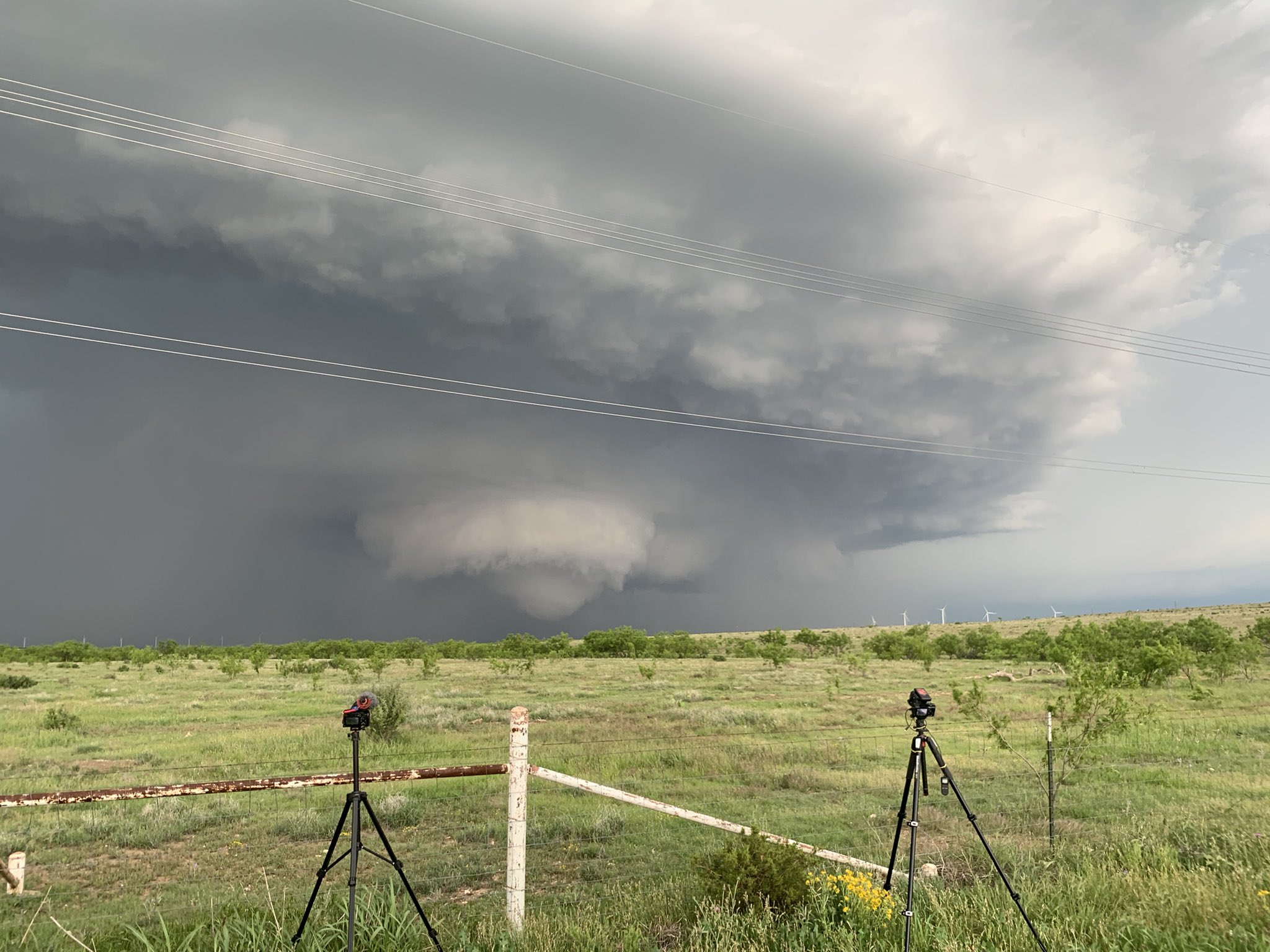
This reportedly that tornado, image from @robhoffimagery on Twitter
4 likes
Winter time post are almost exclusively focused on the DFW area.
-
ElectricStorm
- Category 5
- Posts: 5147
- Age: 25
- Joined: Tue Aug 13, 2019 11:23 pm
- Location: Norman, OK
Re: Texas Spring 2021
Looks like a tornado warned storm is moving right towards Lubbock. Nothing confirmed yet but it is warned for tennis ball hail
0 likes
B.S Meteorology, University of Oklahoma '25
Please refer to the NHC, NWS, or SPC for official information.
Please refer to the NHC, NWS, or SPC for official information.
-
bubba hotep
- S2K Supporter
- Posts: 6014
- Joined: Wed Dec 28, 2016 1:00 am
- Location: Collin County Texas
Re: Texas Spring 2021
Based on current radar, it looks like the 00z CAMs have a poor handle on the convection across North Texas.
0 likes
Winter time post are almost exclusively focused on the DFW area.
-
bubba hotep
- S2K Supporter
- Posts: 6014
- Joined: Wed Dec 28, 2016 1:00 am
- Location: Collin County Texas
Re: Texas Spring 2021
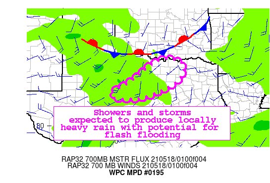
Mesoscale Precipitation Discussion 0195
NWS Weather Prediction Center College Park MD
1101 PM EDT Mon May 17 2021
Areas affected......North Texas...
Concerning...Heavy rainfall...Flash flooding possible
Valid 180301Z - 180801Z
SUMMARY...A cluster of showers and thunderstorms will continue to
move east overnight, with rainfall rates of 1-2 inches per hour.
Local mergers should result in heavy rain with isolated flash
flood potential.
DISCUSSION...Satellite and radar imagery show a broken band of
showers/storms moving east across northwest to north Texas.
An approaching 700 mb shortwave was helping to induce lift in
conjunction with a well defined 300 mb divergence maxima and
low-mid level warm/moisture advection. The environment downstream
has favorable lapse rates as the 00z FWD sounding showed lapse
rates of 8 deg c/km in the 700-500 mb layer.
Guidance is variable across the region on potential rainfall, with
the 00-01z HRRR and 18z HREF blended mean showing clusters of
1.5-2 inches of rain through 09z.
Since these values are in a similar range to 3 hour flash flood
guidance, a risk exists that localized mergers and clusters of
briefly training showers/storms may produce rainfall that exceeds
flash flood guidance.
The WRF ARW, ARW2 and parent NAM and NAM Conus Nest appear to lag
behind, showing QPF further west, where activity has passed. More
weighting was given to the further east HRRR and blended HREF
Mean, which appeared to track the slightly further east trends
shown in radar/satellite.
Petersen
ATTN...WFO...FWD...OUN...SJT...
ATTN...RFC...ABRFC...LMRFC...WGRFC...NWC...
0 likes
Winter time post are almost exclusively focused on the DFW area.
-
rwfromkansas
- Category 5
- Posts: 3038
- Joined: Sat Aug 27, 2005 12:47 am
- Location: North Fort Worth
Re: Texas Spring 2021
It rained .19 overnight. Thought we had a deluge coming. Got me over 2 inches though. Been a very wet month.
More is coming, and some just fired up.
More is coming, and some just fired up.
1 likes
Re: Texas Spring 2021
0.66" Sunday and 1.5" yesterday. I woke up expecting it to be raining, but I was pretty surprised when the sun was peeking through the clouds. More fuel for the fire this afternoon...
1 likes
-
InfernoFlameCat

- Category 5
- Posts: 2127
- Age: 22
- Joined: Mon Dec 14, 2020 10:52 am
- Location: Buford, GA
Re: Texas Spring 2021
We could see >10 inches in deep southern Texas. Texas weather is crazy.
1 likes
I am by no means a professional. DO NOT look at my forecasts for official information or make decisions based on what I post.
Goal: to become a registered expert over tropical and subtropical cyclones.
Goal: to become a registered expert over tropical and subtropical cyclones.