Texas Spring 2026

U.S. & Caribbean Weather Discussions and Severe Weather Events

Moderator: S2k Moderators

Forum rules

The posts in this forum are NOT official forecast and should not be used as such. They are just the opinion of the poster and may or may not be backed by sound meteorological data. They are NOT endorsed by any professional institution or STORM2K.

Help Support Storm2K
Message
Author
Brent
S2K Supporter
S2K Supporter
Posts: 38790
Age: 37
Joined: Sun May 16, 2004 10:30 pm
Location: Tulsa Oklahoma
Contact:

Re: Texas Spring 2026

#721 Postby Brent » Wed Apr 15, 2026 8:18 am

Cpv17 wrote:
Brent wrote:Lol we apparently had a spinup somewhere at 10pm out of absolutely nowhere

That is twice for us in the last 6 weeks... DFW can take it now :spam:

I've never even had a year with two scares that I can remember here... And it's only mid April :double: like this isn't even our peak season. This is when usually Dixie is going off


Y’all are gonna get clobbered later today lol


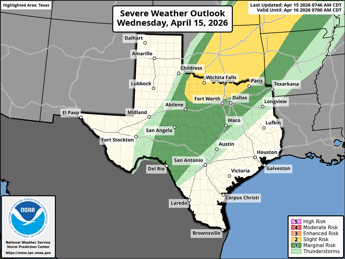
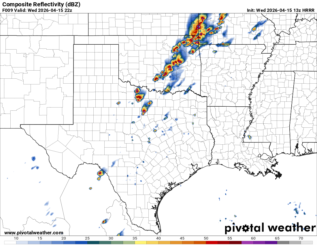
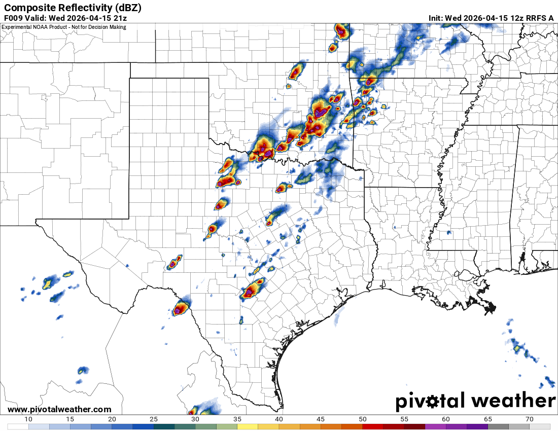
Maybe we'll see... They seem to think it's more southeast today. At least it probably comes through a lot earlier? The HRRR is heavily focused to the southeast for sure

Then again it's been like good luck figuring this weather out :lol: there was absolutely nothing going on before that spinup here and it was already past us before the sirens went off. It was bizarre

Also I've seen absolutely no damage in the city... They had to go somewhere else for a live shot. If that thing touched down where radar said it was it would be wall to wall coverage :lol:

Now Friday has a lot more hype
0 likes   
#neversummer

User avatar
wxman22
Category 5
Category 5
Posts: 2061
Joined: Mon Jan 30, 2006 12:39 am
Location: Wichita Falls, TX
Contact:

Re: Texas Spring 2026

#722 Postby wxman22 » Wed Apr 15, 2026 9:25 am

Here we go again. What will the dryline bring today? lol

Image
Image
Image
0 likes   

rwfromkansas
Category 5
Category 5
Posts: 3074
Joined: Sat Aug 27, 2005 12:47 am
Location: North Fort Worth

Re: Texas Spring 2026

#723 Postby rwfromkansas » Wed Apr 15, 2026 9:48 am

HockeyTx82 wrote:Is today the day for DFW?


Nope.
1 likes   

TomballEd
Category 5
Category 5
Posts: 1339
Age: 62
Joined: Wed Aug 16, 2023 4:52 pm
Location: Spring/Klein area, not Tomball

Re: Texas Spring 2026

#724 Postby TomballEd » Wed Apr 15, 2026 10:06 am

rwfromkansas wrote:
HockeyTx82 wrote:Is today the day for DFW?


Nope.


Marginal risk might playout. I know I was all depressed last week about the heavy rain missing us and 3 of 4 days when precip chances were low we got good rain, 4 inches in one day.

IIRC in Austin, like the late May or early H=June day in 1994 I was taking my Petroleum Project Finance final (build spreadsheets, calculate risk adjusted NPV and IRR, pay taxes) and bubbling storm NW of campus which dumped windshield shattering hail as I found out when my friends and I went to see a movie and the parking lot was full of smashed automotive glass. I always knew when something was forecast and nothing much was forecast.

13Z HRRR gets marginally severe hail as close as Wise and Parker counties and car denting hail near SPS.
0 likes   

User avatar
ElectricStorm
Category 5
Category 5
Posts: 5164
Age: 25
Joined: Tue Aug 13, 2019 11:23 pm
Location: Norman, OK

Re: Texas Spring 2026

#725 Postby ElectricStorm » Wed Apr 15, 2026 10:54 am

Impressive 12z OUN sounding, certainly what you would expect to see on a severe weather day.

Could be a little veer-back-veer action and combined with a likey linear messy storm mode, tornado threat may be limited but could easily see some QLCS spinups.

Friday still looks interesting but I do have concerns about capping. Shear vectors are much more perpendicular to the dryline compared to yesterday and today which would be more favorable for discrete supercell development if they can break the cap.
0 likes   
B.S Meteorology, University of Oklahoma '25

Please refer to the NHC, NWS, or SPC for official information.

User avatar
Ntxw
Storm2k Moderator
Storm2k Moderator
Posts: 23567
Joined: Wed Oct 21, 2009 6:34 pm
Location: DFW, Texas

Re: Texas Spring 2026

#726 Postby Ntxw » Wed Apr 15, 2026 11:46 am

TomballEd wrote:
rwfromkansas wrote:
HockeyTx82 wrote:Is today the day for DFW?


Nope.


Marginal risk might playout. I know I was all depressed last week about the heavy rain missing us and 3 of 4 days when precip chances were low we got good rain, 4 inches in one day.

IIRC in Austin, like the late May or early H=June day in 1994 I was taking my Petroleum Project Finance final (build spreadsheets, calculate risk adjusted NPV and IRR, pay taxes) and bubbling storm NW of campus which dumped windshield shattering hail as I found out when my friends and I went to see a movie and the parking lot was full of smashed automotive glass. I always knew when something was forecast and nothing much was forecast.

13Z HRRR gets marginally severe hail as close as Wise and Parker counties and car denting hail near SPS.


What's a year or two of insurance increases to recoup losses regionwide? :lol:.
1 likes   
The above post and any post by Ntxw is NOT an official forecast and should not be used as such. It is just the opinion of the poster and may or may not be backed by sound meteorological data. It is NOT endorsed by any professional institution including Storm2k. For official information, please refer to NWS products.

  Help support Storm2K!
Help Support Storm2K

HockeyTx82
S2K Supporter
S2K Supporter
Posts: 2829
Joined: Tue Oct 27, 2009 11:17 am
Location: Ponder, TX

Re: Texas Spring 2026

#727 Postby HockeyTx82 » Wed Apr 15, 2026 12:19 pm

Ntxw wrote:
TomballEd wrote:
rwfromkansas wrote:
Nope.


Marginal risk might playout. I know I was all depressed last week about the heavy rain missing us and 3 of 4 days when precip chances were low we got good rain, 4 inches in one day.

IIRC in Austin, like the late May or early H=June day in 1994 I was taking my Petroleum Project Finance final (build spreadsheets, calculate risk adjusted NPV and IRR, pay taxes) and bubbling storm NW of campus which dumped windshield shattering hail as I found out when my friends and I went to see a movie and the parking lot was full of smashed automotive glass. I always knew when something was forecast and nothing much was forecast.

13Z HRRR gets marginally severe hail as close as Wise and Parker counties and car denting hail near SPS.


What's a year or two of insurance increases to recoup losses regionwide? :lol:.


Well it's looking like Denton County might get in the action later which would impact me, but I'm not sure of the severity of what it's showing. The discrete cells seem to be disappearing on runs and more of a quick linear line moving through maybe. Anybody else care to check my thoughts?

Also of note there's some returns on the Radar and the clouds are holding pretty thick, so I'm not sure how much energy we would have in this area would have later.
0 likes   
Don't hold me accountable for anything I post on this forum. Leave the real forecasting up to the professionals.

Location: Ponder, TX (all observation posts are this location unless otherwise noted)

User avatar
Ntxw
Storm2k Moderator
Storm2k Moderator
Posts: 23567
Joined: Wed Oct 21, 2009 6:34 pm
Location: DFW, Texas

Re: Texas Spring 2026

#728 Postby Ntxw » Wed Apr 15, 2026 12:33 pm

HockeyTx82 wrote:
Ntxw wrote:
TomballEd wrote:

Marginal risk might playout. I know I was all depressed last week about the heavy rain missing us and 3 of 4 days when precip chances were low we got good rain, 4 inches in one day.

IIRC in Austin, like the late May or early H=June day in 1994 I was taking my Petroleum Project Finance final (build spreadsheets, calculate risk adjusted NPV and IRR, pay taxes) and bubbling storm NW of campus which dumped windshield shattering hail as I found out when my friends and I went to see a movie and the parking lot was full of smashed automotive glass. I always knew when something was forecast and nothing much was forecast.

13Z HRRR gets marginally severe hail as close as Wise and Parker counties and car denting hail near SPS.


What's a year or two of insurance increases to recoup losses regionwide? :lol:.


Well it's looking like Denton County might get in the action later which would impact me, but I'm not sure of the severity of what it's showing. The discrete cells seem to be disappearing on runs and more of a quick linear line moving through maybe. Anybody else care to check my thoughts?

Also of note there's some returns on the Radar and the clouds are holding pretty thick, so I'm not sure how much energy we would have in this area would have later.


Areas to the west may see some isolated to scattered severe weather this afternoon, for most of us in the population center will likely be after dark a more congealed area, especially on the north side. Typical April thunderstorms.

Bigger story is this weekend! Saturday is 50s for highs and 40s for lows, with below normal temps lasting through early next week.
0 likes   
The above post and any post by Ntxw is NOT an official forecast and should not be used as such. It is just the opinion of the poster and may or may not be backed by sound meteorological data. It is NOT endorsed by any professional institution including Storm2k. For official information, please refer to NWS products.


  Help support Storm2K!

Help Support Storm2K


Stratton23
Category 5
Category 5
Posts: 3594
Joined: Fri Jul 21, 2023 10:59 pm
Location: Katy, Tx

Re: Texas Spring 2026

#729 Postby Stratton23 » Wed Apr 15, 2026 12:52 pm

Next week could potentially be very stormy/ wet and cooler than average with a west based - NAO block retrograding into central canada, flooding may become more of a concern next week as models are hinting at a slow moving storm system that could get trapped under neath blocking in canada
0 likes   

Gotwood
Category 2
Category 2
Posts: 793
Joined: Wed Dec 14, 2022 7:18 pm
Location: Brock Tx

Re: Texas Spring 2026

#730 Postby Gotwood » Wed Apr 15, 2026 1:57 pm

I would just like some rain for my garden. Guess we will see.
0 likes   

TomballEd
Category 5
Category 5
Posts: 1339
Age: 62
Joined: Wed Aug 16, 2023 4:52 pm
Location: Spring/Klein area, not Tomball

Re: Texas Spring 2026

#731 Postby TomballEd » Wed Apr 15, 2026 2:23 pm

Watch issuance probs 80%

Image
/
Image
0 likes   

HockeyTx82
S2K Supporter
S2K Supporter
Posts: 2829
Joined: Tue Oct 27, 2009 11:17 am
Location: Ponder, TX

Re: Texas Spring 2026

#732 Postby HockeyTx82 » Wed Apr 15, 2026 2:45 pm

So is the Tornado watch that just went up based off that meso discussion that looked like it was down in Texas and Oklahoma but they opted to go Red River North?
0 likes   
Don't hold me accountable for anything I post on this forum. Leave the real forecasting up to the professionals.

Location: Ponder, TX (all observation posts are this location unless otherwise noted)

TomballEd
Category 5
Category 5
Posts: 1339
Age: 62
Joined: Wed Aug 16, 2023 4:52 pm
Location: Spring/Klein area, not Tomball

Re: Texas Spring 2026

#733 Postby TomballEd » Wed Apr 15, 2026 3:10 pm

HockeyTx82 wrote:So is the Tornado watch that just went up based off that meso discussion that looked like it was down in Texas and Oklahoma but they opted to go Red River North?


That is what it looks like.
1 likes   

User avatar
wxman22
Category 5
Category 5
Posts: 2061
Joined: Mon Jan 30, 2006 12:39 am
Location: Wichita Falls, TX
Contact:

Re: Texas Spring 2026

#734 Postby wxman22 » Wed Apr 15, 2026 3:35 pm

I’m currently getting some dime size to nickel size hail with crazy heavy rain right now!

Image

Image
Last edited by wxman22 on Wed Apr 15, 2026 4:39 pm, edited 2 times in total.
1 likes   

User avatar
Ntxw
Storm2k Moderator
Storm2k Moderator
Posts: 23567
Joined: Wed Oct 21, 2009 6:34 pm
Location: DFW, Texas

Re: Texas Spring 2026

#735 Postby Ntxw » Wed Apr 15, 2026 3:54 pm

Big GFS upgrade in time for next winter. Not just minor tweaks but significant coupling of land, sea, and air.

https://www.storm2k.org/phpbb2/viewtopic.php?f=31&t=125240

We often cite models struggle with terrain, maybe this will help?
4 likes   
The above post and any post by Ntxw is NOT an official forecast and should not be used as such. It is just the opinion of the poster and may or may not be backed by sound meteorological data. It is NOT endorsed by any professional institution including Storm2k. For official information, please refer to NWS products.


  Help support Storm2K!

Help Support Storm2K


User avatar
wxman22
Category 5
Category 5
Posts: 2061
Joined: Mon Jan 30, 2006 12:39 am
Location: Wichita Falls, TX
Contact:

Re: Texas Spring 2026

#736 Postby wxman22 » Wed Apr 15, 2026 4:51 pm

Severe thunderstorm watch issued.

Image
0 likes   

Brent
S2K Supporter
S2K Supporter
Posts: 38790
Age: 37
Joined: Sun May 16, 2004 10:30 pm
Location: Tulsa Oklahoma
Contact:

Re: Texas Spring 2026

#737 Postby Brent » Wed Apr 15, 2026 5:16 pm

Unless something blows up soon I don't think this is gonna be a repeat of last night here. It's much more focused to the south and east. Also so far it's just marginal hailers

OKC keeps escaping too somehow isn't that amazing. It's their turn also :lol:

We shall see what Friday brings. Im not gonna worry about it right now

In other news the sirens went off after the storm was past us last night. They had also malfunctioned in Owasso after the storm in March :spam:

For what it's worth it looks like there's a big cluster of storms in DFW around 8-10pm
Last edited by Brent on Wed Apr 15, 2026 5:41 pm, edited 2 times in total.
0 likes   
#neversummer

User avatar
wxman22
Category 5
Category 5
Posts: 2061
Joined: Mon Jan 30, 2006 12:39 am
Location: Wichita Falls, TX
Contact:

Re: Texas Spring 2026

#738 Postby wxman22 » Wed Apr 15, 2026 5:35 pm

Beautiful supercell structures in these storms today up here. We're getting multiple supercells training over the same areas. Somebody's gonna end up with a lot of rain today.

Image
Last edited by wxman22 on Wed Apr 15, 2026 6:11 pm, edited 1 time in total.
1 likes   

User avatar
Quixotic
Category 4
Category 4
Posts: 963
Joined: Tue Feb 14, 2017 12:27 am
Location: Frisco

Re: Texas Spring 2026

#739 Postby Quixotic » Wed Apr 15, 2026 6:00 pm

That one near archer city looks like a hook.
0 likes   

User avatar
CaptinCrunch
S2K Supporter
S2K Supporter
Posts: 8787
Age: 58
Joined: Mon Nov 03, 2003 4:33 pm
Location: Kennedale, TX (Tarrant Co.)

Re: Texas Spring 2026

#740 Postby CaptinCrunch » Wed Apr 15, 2026 6:01 pm

Mostly the radar echoes are not reaching the ground, so another swing and a miss for measurable rain in DFW .20" total over the last week in southern Tarrant. Heaviest shower was while driving down I20 this past Sunday when a nice hard downpour occurred that was about 100 yards wide and last less than 2 minutes.

Sorry guys but after all the hype and pretty colored images of 1"-2" rainfall maps across DFW, it really has been a bust for DFW metro area. :(
0 likes   


Return to “USA & Caribbean Weather”

Who is online

Users browsing this forum: No registered users and 88 guests