C/S TX Weather: Seasonal with some rains
Moderator: S2k Moderators
Forum rules

The posts in this forum are NOT official forecast and should not be used as such. They are just the opinion of the poster and may or may not be backed by sound meteorological data. They are NOT endorsed by any professional institution or STORM2K.
-
Rgv20

- S2K Supporter

- Posts: 2466
- Age: 39
- Joined: Wed Jan 05, 2011 5:42 pm
- Location: Edinburg/McAllen Tx
Portastorm and Shoshana can you guys smell the rain? 
0 likes
The following post is NOT an official forecast and should not be used as such. It is just the opinion of the poster and may or may not be backed by sound meteorological data. It is NOT endorsed by any professional institution including storm2k.org For Official Information please refer to the NHC and NWS products.

-
Rgv20
- S2K Supporter
- Posts: 2466
- Age: 39
- Joined: Wed Jan 05, 2011 5:42 pm
- Location: Edinburg/McAllen Tx
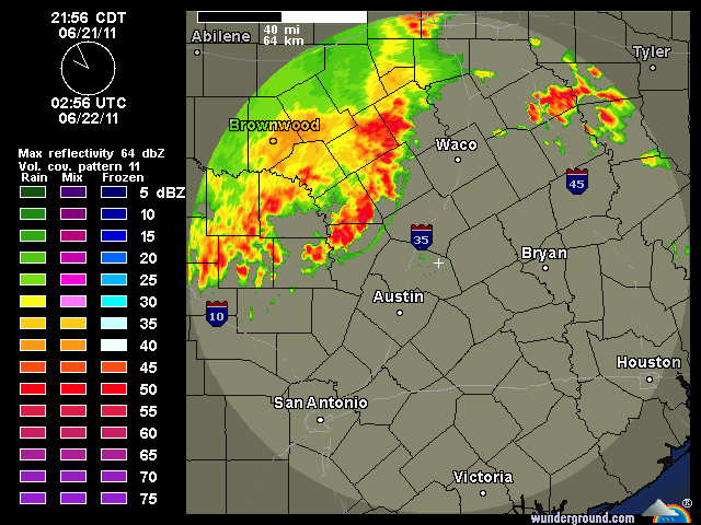
Severe Thunderstorm Warning including Austin
SEVERE THUNDERSTORM WARNING
TXC031-053-091-209-259-453-491-220545-
/O.NEW.KEWX.SV.W.0107.110622T0449Z-110622T0545Z/
BULLETIN - EAS ACTIVATION REQUESTED
SEVERE THUNDERSTORM WARNING
NATIONAL WEATHER SERVICE AUSTIN/SAN ANTONIO TX
1149 PM CDT TUE JUN 21 2011
THE NATIONAL WEATHER SERVICE IN AUSTIN SAN ANTONIO HAS ISSUED A
* SEVERE THUNDERSTORM WARNING FOR...
BLANCO COUNTY...
SOUTH CENTRAL BURNET COUNTY...
COMAL COUNTY...
HAYS COUNTY...
KENDALL COUNTY...
TRAVIS COUNTY...
WILLIAMSON COUNTY...
* UNTIL 1245 AM CDT.
* AT 1143 PM CDT...NWS METEOROLOGISTS HAVE DETECTED A LINE OF SEVERE
THUNDERSTORMS CAPABLE OF PRODUCING DAMAGING WINDS IN EXCESS OF 60
MPH. THESE STORMS WERE LOCATED ALONG A LINE EXTENDING FROM 7 MILES
SOUTHWEST OF LIBERTY HILL TO BLANCO TO TO 7 MILES NORTHWEST OF
BOERNE...AND MOVING SOUTHEAST AT 20 MPH.
* SOME LOCATIONS IN THE WARNING INCLUDE WALNUT GROVE...LAGO VISTA...
PAYTON...HENLY...KENDALIA...KREUTZBERG...LEANDER...TWIN SISTERS...
SERENADA...SUN CITY...LAKEWAY...GEORGETOWN DAM...GEORGETOWN...
GUADALUPE RIVER ST...BERGHEIM...DRIPPING SPRINGS...BEE CAVE...
ANDERSON MILL...MANSFIELD DAM...WEIR...FISCHER...SPRING BRANCH...
ROUND ROCK...DRIFTWOOD...WOODCREEK...GRANGER...WIMBERLEY...WEST
LAKE HILLS...WINDEMERE...CANYON LAKE DAM...TANGLEWOOD FOREST...
ROLLINGWOOD...PFLUGERVILLE...AUSTIN...TAYLOR...HUTTO AND GRANGER
DAM.
THIS LINE OF STORMS WILL APPROACH THE I-35 CORRIDOR FROM
NEW BRAUNFELS TO SAN MARCOS TO AUSTIN TO GEORGETOWN TO JARRELL BY
1245 AM CDT.
VERY HEAVY RAINS AND HAIL UP TO PENNIES CAN ALSO BE EXPECTED.
PRECAUTIONARY/PREPAREDNESS ACTIONS...
THIS IS A DANGEROUS STORM. IF YOU ARE IN ITS PATH...PREPARE
IMMEDIATELY FOR DAMAGING WINDS...DESTRUCTIVE HAIL...AND DEADLY CLOUD
TO GROUND LIGHTNING. PEOPLE OUTSIDE SHOULD MOVE TO A SHELTER...
PREFERABLY INSIDE A STRONG BUILDING BUT AWAY FROM WINDOWS.
A SEVERE THUNDERSTORM WATCH REMAINS IN EFFECT UNTIL 100 AM CDT
WEDNESDAY MORNING FOR SOUTH CENTRAL TEXAS.
&&
LAT...LON 3070 9725 2971 9823 2986 9886 3079 9788
TIME...MOT...LOC 0448Z 307DEG 18KT 3057 9795 3013 9836
2985 9881
$$
SEVERE THUNDERSTORM WARNING
TXC031-053-091-209-259-453-491-220545-
/O.NEW.KEWX.SV.W.0107.110622T0449Z-110622T0545Z/
BULLETIN - EAS ACTIVATION REQUESTED
SEVERE THUNDERSTORM WARNING
NATIONAL WEATHER SERVICE AUSTIN/SAN ANTONIO TX
1149 PM CDT TUE JUN 21 2011
THE NATIONAL WEATHER SERVICE IN AUSTIN SAN ANTONIO HAS ISSUED A
* SEVERE THUNDERSTORM WARNING FOR...
BLANCO COUNTY...
SOUTH CENTRAL BURNET COUNTY...
COMAL COUNTY...
HAYS COUNTY...
KENDALL COUNTY...
TRAVIS COUNTY...
WILLIAMSON COUNTY...
* UNTIL 1245 AM CDT.
* AT 1143 PM CDT...NWS METEOROLOGISTS HAVE DETECTED A LINE OF SEVERE
THUNDERSTORMS CAPABLE OF PRODUCING DAMAGING WINDS IN EXCESS OF 60
MPH. THESE STORMS WERE LOCATED ALONG A LINE EXTENDING FROM 7 MILES
SOUTHWEST OF LIBERTY HILL TO BLANCO TO TO 7 MILES NORTHWEST OF
BOERNE...AND MOVING SOUTHEAST AT 20 MPH.
* SOME LOCATIONS IN THE WARNING INCLUDE WALNUT GROVE...LAGO VISTA...
PAYTON...HENLY...KENDALIA...KREUTZBERG...LEANDER...TWIN SISTERS...
SERENADA...SUN CITY...LAKEWAY...GEORGETOWN DAM...GEORGETOWN...
GUADALUPE RIVER ST...BERGHEIM...DRIPPING SPRINGS...BEE CAVE...
ANDERSON MILL...MANSFIELD DAM...WEIR...FISCHER...SPRING BRANCH...
ROUND ROCK...DRIFTWOOD...WOODCREEK...GRANGER...WIMBERLEY...WEST
LAKE HILLS...WINDEMERE...CANYON LAKE DAM...TANGLEWOOD FOREST...
ROLLINGWOOD...PFLUGERVILLE...AUSTIN...TAYLOR...HUTTO AND GRANGER
DAM.
THIS LINE OF STORMS WILL APPROACH THE I-35 CORRIDOR FROM
NEW BRAUNFELS TO SAN MARCOS TO AUSTIN TO GEORGETOWN TO JARRELL BY
1245 AM CDT.
VERY HEAVY RAINS AND HAIL UP TO PENNIES CAN ALSO BE EXPECTED.
PRECAUTIONARY/PREPAREDNESS ACTIONS...
THIS IS A DANGEROUS STORM. IF YOU ARE IN ITS PATH...PREPARE
IMMEDIATELY FOR DAMAGING WINDS...DESTRUCTIVE HAIL...AND DEADLY CLOUD
TO GROUND LIGHTNING. PEOPLE OUTSIDE SHOULD MOVE TO A SHELTER...
PREFERABLY INSIDE A STRONG BUILDING BUT AWAY FROM WINDOWS.
A SEVERE THUNDERSTORM WATCH REMAINS IN EFFECT UNTIL 100 AM CDT
WEDNESDAY MORNING FOR SOUTH CENTRAL TEXAS.
&&
LAT...LON 3070 9725 2971 9823 2986 9886 3079 9788
TIME...MOT...LOC 0448Z 307DEG 18KT 3057 9795 3013 9836
2985 9881
$$
0 likes
The following post is NOT an official forecast and should not be used as such. It is just the opinion of the poster and may or may not be backed by sound meteorological data. It is NOT endorsed by any professional institution including storm2k.org For Official Information please refer to the NHC and NWS products.
-
Portastorm

- Storm2k Moderator

- Posts: 9955
- Age: 63
- Joined: Fri Jul 11, 2003 9:16 am
- Location: Round Rock, TX
- Contact:
Re: C/SC TX Weather: Frying Pan Summer
Portastorm Weather Center meteorologists could be found dancing in the streets last night and early this morning as rain fell on the Austin area. The PWC measured 1.35 inches of rain which fell between 12 midnight and 6 a.m. today. Whoo-hoo!!! 
0 likes
Any forecasts under my name are to be taken with a grain of salt. Get your best forecasts from the National Weather Service and National Hurricane Center.
-
Tireman4

- S2K Supporter
- Posts: 5903
- Age: 60
- Joined: Fri Jun 30, 2006 1:08 pm
- Location: Humble, Texas
- Contact:
Re: C/SC TX Weather: Frying Pan Summer
Portastorm wrote:Portastorm Weather Center meteorologists could be found dancing in the streets last night and early this morning as rain fell on the Austin area. The PWC measured 1.35 inches of rain which fell between 12 midnight and 6 a.m. today. Whoo-hoo!!!
Pass the Grey Goose boys!!
0 likes
-
vbhoutex

- Storm2k Executive

- Posts: 29149
- Age: 74
- Joined: Wed Oct 09, 2002 11:31 pm
- Location: Cypress, TX
- Contact:
Re: C/SC TX Weather: Frying Pan Summer
Tireman4 wrote:Portastorm wrote:Portastorm Weather Center meteorologists could be found dancing in the streets last night and early this morning as rain fell on the Austin area. The PWC measured 1.35 inches of rain which fell between 12 midnight and 6 a.m. today. Whoo-hoo!!!
Pass the Grey Goose boys!!
We may need a case before this is all over between PWS and SE TX!!
I sure hope we get as much as you guys did!!
0 likes
Skywarn, C.E.R.T.
Please click below to donate to STORM2K to help with the expenses of keeping the site going:

Please click below to donate to STORM2K to help with the expenses of keeping the site going:
-
Portastorm
- Storm2k Moderator
- Posts: 9955
- Age: 63
- Joined: Fri Jul 11, 2003 9:16 am
- Location: Round Rock, TX
- Contact:
-
vbhoutex
- Storm2k Executive
- Posts: 29149
- Age: 74
- Joined: Wed Oct 09, 2002 11:31 pm
- Location: Cypress, TX
- Contact:
Re:
Portastorm wrote:I'm also digging these high temps today ... sitting at 87 degrees here at 3 p.m. What a nice change!
Loving the temps in SE TX too. Woke up to 67f and rain and thunder. High today-82.4f. Like you guys we haven't hardly seen lows like that for a while(actually we have been having high 70's to low 80's). That is 12f below our lowest official high this so far this month. So glad we all got something out of this. I fear it will be a while before we see something like this again.
0 likes
Skywarn, C.E.R.T.
Please click below to donate to STORM2K to help with the expenses of keeping the site going:
Please click below to donate to STORM2K to help with the expenses of keeping the site going:
-
Rgv20
- S2K Supporter
- Posts: 2466
- Age: 39
- Joined: Wed Jan 05, 2011 5:42 pm
- Location: Edinburg/McAllen Tx
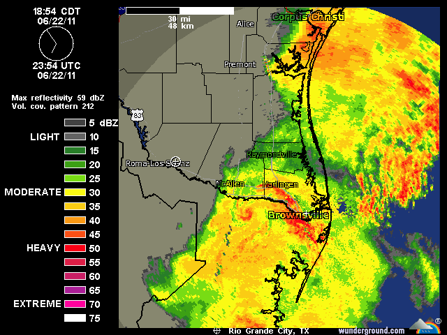
Some heavy rain for Brownsville and Harlingen.
0 likes
The following post is NOT an official forecast and should not be used as such. It is just the opinion of the poster and may or may not be backed by sound meteorological data. It is NOT endorsed by any professional institution including storm2k.org For Official Information please refer to the NHC and NWS products.

Yup we hit the jackpot here in western Cameron County, wouldn't be surprised if we almost made up our deficit for the year, it was that much. Today and one day back in January are responsible for probably close to 95% of this year's total.
Glad you caught a snapshot of that little spin just south of Progreso in MX, it was there for only a few minutes
Glad you caught a snapshot of that little spin just south of Progreso in MX, it was there for only a few minutes
0 likes
-
bvigal

- S2K Supporter
- Posts: 2276
- Joined: Sun Jul 24, 2005 8:49 am
- Location: British Virgin Islands
- Contact:
Re: C/SC TX Weather: Frying Pan Summer
OK.... who did the rain dance? And why did you wait so long to do it? 
 Congrats to drought-ridden Texas and LA, some rain at last!!
0 likes
-
Portastorm
- Storm2k Moderator
- Posts: 9955
- Age: 63
- Joined: Fri Jul 11, 2003 9:16 am
- Location: Round Rock, TX
- Contact:
Re: C/SC TX Weather: Frying Pan Summer
Happy to see you folks in the Valley shared in the rainfall "fun." Here's hoping for more next week!
0 likes
Any forecasts under my name are to be taken with a grain of salt. Get your best forecasts from the National Weather Service and National Hurricane Center.
-
vbhoutex
- Storm2k Executive
- Posts: 29149
- Age: 74
- Joined: Wed Oct 09, 2002 11:31 pm
- Location: Cypress, TX
- Contact:
Re: C/SC TX Weather: Frying Pan Summer
bvigal wrote:OK.... who did the rain dance? And why did you wait so long to do it?
We've been dancing for weeks!! The drought has been fighting us tooth and toenail, but we finally got through!!!
0 likes
Skywarn, C.E.R.T.
Please click below to donate to STORM2K to help with the expenses of keeping the site going:
Please click below to donate to STORM2K to help with the expenses of keeping the site going:
-
Tireman4
- S2K Supporter
- Posts: 5903
- Age: 60
- Joined: Fri Jun 30, 2006 1:08 pm
- Location: Humble, Texas
- Contact:
Re: C/SC TX Weather: Frying Pan Summer
Portastorm wrote:Happy to see you folks in the Valley shared in the rainfall "fun." Here's hoping for more next week!
I heard the PWC is considering hiring the "Elders" (since they knew what the liquid items falling from the sky was..LOL) for the summer....any truth to that?
0 likes
-
Portastorm
- Storm2k Moderator
- Posts: 9955
- Age: 63
- Joined: Fri Jul 11, 2003 9:16 am
- Location: Round Rock, TX
- Contact:
Re: C/SC TX Weather: Frying Pan Summer
Tireman4 wrote:Portastorm wrote:Happy to see you folks in the Valley shared in the rainfall "fun." Here's hoping for more next week!
I heard the PWC is considering hiring the "Elders" (since they knew what the liquid items falling from the sky was..LOL) for the summer....any truth to that?
Could be some truth in that ... if we combine the "Elders" with vbhoutex's rain dancers down in H-town ... that could be the winning ticket!
0 likes
Any forecasts under my name are to be taken with a grain of salt. Get your best forecasts from the National Weather Service and National Hurricane Center.
-
vbhoutex
- Storm2k Executive
- Posts: 29149
- Age: 74
- Joined: Wed Oct 09, 2002 11:31 pm
- Location: Cypress, TX
- Contact:
Re: C/SC TX Weather: Frying Pan Summer
Portastorm wrote:Tireman4 wrote:Portastorm wrote:Happy to see you folks in the Valley shared in the rainfall "fun." Here's hoping for more next week!
I heard the PWC is considering hiring the "Elders" (since they knew what the liquid items falling from the sky was..LOL) for the summer....any truth to that?
Could be some truth in that ... if we combine the "Elders" with vbhoutex's rain dancers down in H-town ... that could be the winning ticket!
We'll be ready to go!!!

0 likes
Skywarn, C.E.R.T.
Please click below to donate to STORM2K to help with the expenses of keeping the site going:
Please click below to donate to STORM2K to help with the expenses of keeping the site going:
-
Rgv20
- S2K Supporter
- Posts: 2466
- Age: 39
- Joined: Wed Jan 05, 2011 5:42 pm
- Location: Edinburg/McAllen Tx
Re: C/SC TX Weather: Frying Pan Summer
vbhoutex wrote:bvigal wrote:OK.... who did the rain dance? And why did you wait so long to do it?
We've been dancing for weeks!! The drought has been fighting us tooth and toenail, but we finally got through!!!I hope you guys in the valley don't get any flooding from the heavy rain. You need it all to soak in!! We aren't anywhere near breaking our drought here in SE TX but rain 2 days in a road is more than welcome!!
Here are some of the Preliminary totals.
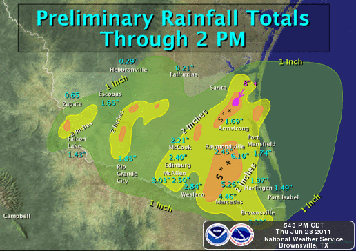
Some of the heavier rainfall totals from Cooperative Weather
Observers around Deep South Texas:
Mercedes - 4.46
Harlingen - 4.33
Santa Ana - 2.85
Weslaco - 2.84
Raymondville - 2.45
Edinburg - 2.40
Los Fresnos - 2.70
Major Airports:
McAllen (Estimated) 3.50
Harlingen - 1.97
Port Isabel - 1.49
Brownsville/SPI - 3.32
-Campbell-
http://www.srh.noaa.gov/graphicast.php?site=bro&gc=4
I tell you guys it was awesome seeing it pouring outside
0 likes
The following post is NOT an official forecast and should not be used as such. It is just the opinion of the poster and may or may not be backed by sound meteorological data. It is NOT endorsed by any professional institution including storm2k.org For Official Information please refer to the NHC and NWS products.
Return to “USA & Caribbean Weather”
Who is online
Users browsing this forum: No registered users and 157 guests