Texas Spring 2021
Moderator: S2k Moderators
Forum rules

The posts in this forum are NOT official forecast and should not be used as such. They are just the opinion of the poster and may or may not be backed by sound meteorological data. They are NOT endorsed by any professional institution or STORM2K.
-
HockeyTx82
- S2K Supporter

- Posts: 2795
- Joined: Tue Oct 27, 2009 11:17 am
- Location: Ponder, TX
Re: Texas Spring 2021
Very heavy rain, a little bit of hail and now the sun is trying to sneak out......... Texas
1 likes
Don't hold me accountable for anything I post on this forum. Leave the real forecasting up to the professionals.
Location: Ponder, TX (all observation posts are this location unless otherwise noted)
Location: Ponder, TX (all observation posts are this location unless otherwise noted)
-
HockeyTx82
- S2K Supporter
- Posts: 2795
- Joined: Tue Oct 27, 2009 11:17 am
- Location: Ponder, TX
Re: Texas Spring 2021
Is the dry line moving at all? I'm not seeing to much eastward movement.
1 likes
Don't hold me accountable for anything I post on this forum. Leave the real forecasting up to the professionals.
Location: Ponder, TX (all observation posts are this location unless otherwise noted)
Location: Ponder, TX (all observation posts are this location unless otherwise noted)
-
ElectricStorm

- Category 5

- Posts: 5147
- Age: 25
- Joined: Tue Aug 13, 2019 11:23 pm
- Location: Norman, OK
Re: Texas Spring 2021
The Walnut Springs cell looks like it's about to produce something significant
0 likes
B.S Meteorology, University of Oklahoma '25
Please refer to the NHC, NWS, or SPC for official information.
Please refer to the NHC, NWS, or SPC for official information.
-
bubba hotep

- S2K Supporter
- Posts: 6014
- Joined: Wed Dec 28, 2016 1:00 am
- Location: Collin County Texas
Re: Texas Spring 2021
Some loud thunder and bright lightning happening with rain getting heavier here atm.
0 likes
-
bubba hotep
- S2K Supporter
- Posts: 6014
- Joined: Wed Dec 28, 2016 1:00 am
- Location: Collin County Texas
Re: Texas Spring 2021
Some odd boundary movements out west, that is either an outflow or the dryline retreating? The cold front should colloid with that westward moving boundary at some point and maybe set off some more storms?

0 likes
Winter time post are almost exclusively focused on the DFW area.
-
HockeyTx82
- S2K Supporter
- Posts: 2795
- Joined: Tue Oct 27, 2009 11:17 am
- Location: Ponder, TX
Re: Texas Spring 2021
bubba hotep wrote:Some odd boundary movements out west, that is either an outflow or the dryline retreating? The cold front should colloid with that westward moving boundary at some point and maybe set off some more storms?
https://i.ibb.co/rxTkrvg/CODNEXLAB-NEXRAD-FWS-N0-Q-20210503-2358-24-100.gif
Was just about to ask that. We've been worked over with rain so I don't think we get it to bad later on?
0 likes
Don't hold me accountable for anything I post on this forum. Leave the real forecasting up to the professionals.
Location: Ponder, TX (all observation posts are this location unless otherwise noted)
Location: Ponder, TX (all observation posts are this location unless otherwise noted)
-
rwfromkansas
- Category 5
- Posts: 3038
- Joined: Sat Aug 27, 2005 12:47 am
- Location: North Fort Worth
Re: Texas Spring 2021
I saw a westward moving boundary colliding with the dryline right before the storms fired. Not sure what it was exactly.
The NWS did say this is an odd setup that could bring post-frontal storms.
The NWS did say this is an odd setup that could bring post-frontal storms.
0 likes
-
HockeyTx82
- S2K Supporter
- Posts: 2795
- Joined: Tue Oct 27, 2009 11:17 am
- Location: Ponder, TX
Re: Texas Spring 2021
rwfromkansas wrote:I saw a westward moving boundary colliding with the dryline right before the storms fired. Not sure what it was exactly.
The NWS did say this is an odd setup that could bring post-frontal storms.
It's a conspiracy

0 likes
Don't hold me accountable for anything I post on this forum. Leave the real forecasting up to the professionals.
Location: Ponder, TX (all observation posts are this location unless otherwise noted)
Location: Ponder, TX (all observation posts are this location unless otherwise noted)
-
Texas Snowman

- Storm2k Moderator

- Posts: 6197
- Joined: Fri Jan 25, 2008 11:29 am
- Location: Denison, Texas
Re: Texas Spring 2021
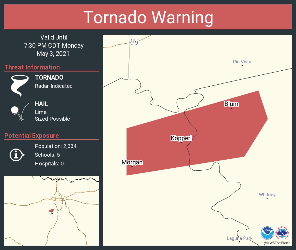
@TxStormChasers — 715PM: Extremely strong circulation moving into Blum in Northwest Hill County. Tornado likely! Be in shelter NOW! #txwx
0 likes
The above post and any post by Texas Snowman is NOT an official forecast and should not be used as such. It is just the opinion of the poster and may or may not be backed by sound meteorological data. It is NOT endorsed by any professional institution including storm2k.org. For official information, please refer to NWS products.
-
Iceresistance

- Category 5
- Posts: 9590
- Age: 22
- Joined: Sat Oct 10, 2020 9:45 am
- Location: Tecumseh, OK/Norman, OK
Re: Texas Spring 2021
HockeyTx82 wrote:rwfromkansas wrote:I saw a westward moving boundary colliding with the dryline right before the storms fired. Not sure what it was exactly.
The NWS did say this is an odd setup that could bring post-frontal storms.
It's a conspiracy
"Post-Frontal storms' means that there could be storms well behind the cold front, it's indeed a odd setup . . .
0 likes
Bill 2015 & Beta 2020
Winter 2020-2021
All observations are in Tecumseh, OK unless otherwise noted.
Winter posts are focused mainly for Oklahoma & Texas.
Take any of my forecasts with a grain of salt, refer to the NWS, SPC, and NHC for official information
Never say Never with weather! Because ANYTHING is possible!
Winter 2020-2021
All observations are in Tecumseh, OK unless otherwise noted.
Winter posts are focused mainly for Oklahoma & Texas.
Take any of my forecasts with a grain of salt, refer to the NWS, SPC, and NHC for official information
Never say Never with weather! Because ANYTHING is possible!
-
Texas Snowman
- Storm2k Moderator
- Posts: 6197
- Joined: Fri Jan 25, 2008 11:29 am
- Location: Denison, Texas
Re: Texas Spring 2021
@NWSFortWorth — 7:12 PM: Brief Tornado has touched down west of Blum, TX. If you are near Blum SEEK SHELTER NOW! #ctxwx
1 likes
The above post and any post by Texas Snowman is NOT an official forecast and should not be used as such. It is just the opinion of the poster and may or may not be backed by sound meteorological data. It is NOT endorsed by any professional institution including storm2k.org. For official information, please refer to NWS products.
-
bubba hotep
- S2K Supporter
- Posts: 6014
- Joined: Wed Dec 28, 2016 1:00 am
- Location: Collin County Texas
Re: Texas Spring 2021
That cell in north Dallas County is a bit concerning. See what it does over the next few scans as it is developing rapidly.
0 likes
Winter time post are almost exclusively focused on the DFW area.
-
Texas Snowman
- Storm2k Moderator
- Posts: 6197
- Joined: Fri Jan 25, 2008 11:29 am
- Location: Denison, Texas
Re: Texas Spring 2021
114
WFUS54 KFWD 040017 RRA
TORFWD
TXC085-040100-
/O.NEW.KFWD.TO.W.0012.210504T0017Z-210504T0100Z/
BULLETIN - EAS ACTIVATION REQUESTED
Tornado Warning
National Weather Service Fort Worth TX
717 PM CDT Mon May 3 2021
The National Weather Service in Fort Worth has issued a
* Tornado Warning for...
Northwestern Collin County in north central Texas...
* Until 800 PM CDT.
* At 717 PM CDT, a severe thunderstorm capable of producing a tornado
was located near Celina, moving east at 20 mph.
HAZARD...Tornado and half dollar size hail.
SOURCE...Radar indicated rotation.
IMPACT...Flying debris will be dangerous to those caught without
shelter. Mobile homes will be damaged or destroyed.
Damage to roofs, windows, and vehicles will occur. Tree
damage is likely.
* This dangerous storm will be near...
McKinney around 725 PM CDT.
Anna and Van Alstyne around 800 PM CDT.
Other locations impacted by this tornadic thunderstorm include
Weston, Melissa and Westminster.
PRECAUTIONARY/PREPAREDNESS ACTIONS...
TAKE COVER NOW! Move to an interior room on the lowest floor of a
sturdy building. Avoid windows. If you are outdoors, in a mobile
home, or in a vehicle, move to the closest substantial shelter and
protect yourself from flying debris.
&&
LAT...LON 3340 9653 3332 9642 3322 9684 3333 9684
3340 9673
TIME...MOT...LOC 0017Z 247DEG 17KT 3328 9681
TORNADO...RADAR INDICATED
HAIL...1.25IN
$$
1 likes
The above post and any post by Texas Snowman is NOT an official forecast and should not be used as such. It is just the opinion of the poster and may or may not be backed by sound meteorological data. It is NOT endorsed by any professional institution including storm2k.org. For official information, please refer to NWS products.
-
Texas Snowman
- Storm2k Moderator
- Posts: 6197
- Joined: Fri Jan 25, 2008 11:29 am
- Location: Denison, Texas
Re: Texas Spring 2021
@spotternetwork — Spotr 2 miles WNW of BLUM, TX @ 00:21 UTC TOR>-Large cone tornado at this location
0 likes
The above post and any post by Texas Snowman is NOT an official forecast and should not be used as such. It is just the opinion of the poster and may or may not be backed by sound meteorological data. It is NOT endorsed by any professional institution including storm2k.org. For official information, please refer to NWS products.
-
Texas Snowman
- Storm2k Moderator
- Posts: 6197
- Joined: Fri Jan 25, 2008 11:29 am
- Location: Denison, Texas
Re: Texas Spring 2021
@DFWScanner — 7:22pm - Tornado WARNING now issued for a portion of Johnson County. Strong rotation with imminent tornado just west of Blum in Hill County moving north/northeast. Residents in the Rio Vista and Blum areas need to SEEK SHELTER NOW!
0 likes
The above post and any post by Texas Snowman is NOT an official forecast and should not be used as such. It is just the opinion of the poster and may or may not be backed by sound meteorological data. It is NOT endorsed by any professional institution including storm2k.org. For official information, please refer to NWS products.
-
Iceresistance
- Category 5
- Posts: 9590
- Age: 22
- Joined: Sat Oct 10, 2020 9:45 am
- Location: Tecumseh, OK/Norman, OK
Re: Texas Spring 2021
Texas Snowman wrote:@DFWScanner — 7:22pm - Tornado WARNING now issued for a portion of Johnson County. Strong rotation with imminent tornado just west of Blum in Hill County moving north/northeast. Residents in the Rio Vista and Blum areas need to SEEK SHELTER NOW!
PDS Tornado Warning for Blum, TX
0 likes
Bill 2015 & Beta 2020
Winter 2020-2021
All observations are in Tecumseh, OK unless otherwise noted.
Winter posts are focused mainly for Oklahoma & Texas.
Take any of my forecasts with a grain of salt, refer to the NWS, SPC, and NHC for official information
Never say Never with weather! Because ANYTHING is possible!
Winter 2020-2021
All observations are in Tecumseh, OK unless otherwise noted.
Winter posts are focused mainly for Oklahoma & Texas.
Take any of my forecasts with a grain of salt, refer to the NWS, SPC, and NHC for official information
Never say Never with weather! Because ANYTHING is possible!
-
Texas Snowman
- Storm2k Moderator
- Posts: 6197
- Joined: Fri Jan 25, 2008 11:29 am
- Location: Denison, Texas
Re: Texas Spring 2021
@DFWScanner — 7:24pm - A storm spotter reports a large tornado in progress ~3 miles west/northwest of Blum. This tornado will be moving north towards the Rio Vista area. Residents in Rio Vista and southern Johnson County, especially along 174, SEEK SHELTER NOW.
0 likes
The above post and any post by Texas Snowman is NOT an official forecast and should not be used as such. It is just the opinion of the poster and may or may not be backed by sound meteorological data. It is NOT endorsed by any professional institution including storm2k.org. For official information, please refer to NWS products.
-
Texas Snowman
- Storm2k Moderator
- Posts: 6197
- Joined: Fri Jan 25, 2008 11:29 am
- Location: Denison, Texas
Re: Texas Spring 2021
685
WWUS54 KFWD 040024
SVSFWD
Severe Weather Statement
National Weather Service Fort Worth TX
724 PM CDT Mon May 3 2021
TXC217-251-040100-
/O.CON.KFWD.TO.W.0011.000000T0000Z-210504T0100Z/
Johnson TX-Hill TX-
724 PM CDT Mon May 3 2021
...A TORNADO WARNING REMAINS IN EFFECT UNTIL 800 PM CDT FOR
SOUTHEASTERN JOHNSON AND NORTHWESTERN HILL COUNTIES...
At 723 PM CDT, a confirmed tornado was located just northwest of
Blum, or 10 miles south of Cleburne, moving northeast at 15 mph.
This is a PARTICULARLY DANGEROUS SITUATION. TAKE COVER NOW!
HAZARD...Damaging tornado.
SOURCE...Weather spotters confirmed tornado.
IMPACT...You are in a life-threatening situation. Flying debris may
be deadly to those caught without shelter. Mobile homes
will be destroyed. Considerable damage to homes,
businesses, and vehicles is likely and complete destruction
is possible.
Other locations impacted by this tornadic thunderstorm include Rio
Vista.
PRECAUTIONARY/PREPAREDNESS ACTIONS...
To repeat, a tornado is on the ground. To protect your life, TAKE
COVER NOW! Move to an interior room on the lowest floor of a sturdy
building and avoid windows. If you are outdoors or in a vehicle,
move to the closest substantial shelter and protect yourself from
flying debris.
Heavy rainfall may hide this tornado. Do not wait to see or hear the
tornado. TAKE COVER NOW!
&&
LAT...LON 3218 9746 3231 9738 3231 9717 3216 9717
3212 9745
TIME...MOT...LOC 0023Z 237DEG 15KT 3216 9743
TORNADO...OBSERVED
TORNADO DAMAGE THREAT...CONSIDERABLE
HAIL...1.75IN
$$
0 likes
The above post and any post by Texas Snowman is NOT an official forecast and should not be used as such. It is just the opinion of the poster and may or may not be backed by sound meteorological data. It is NOT endorsed by any professional institution including storm2k.org. For official information, please refer to NWS products.
-
Iceresistance
- Category 5
- Posts: 9590
- Age: 22
- Joined: Sat Oct 10, 2020 9:45 am
- Location: Tecumseh, OK/Norman, OK
Re: Texas Spring 2021
3 inch Hail has been reported near Rio Vista, TX
0 likes
Bill 2015 & Beta 2020
Winter 2020-2021
All observations are in Tecumseh, OK unless otherwise noted.
Winter posts are focused mainly for Oklahoma & Texas.
Take any of my forecasts with a grain of salt, refer to the NWS, SPC, and NHC for official information
Never say Never with weather! Because ANYTHING is possible!
Winter 2020-2021
All observations are in Tecumseh, OK unless otherwise noted.
Winter posts are focused mainly for Oklahoma & Texas.
Take any of my forecasts with a grain of salt, refer to the NWS, SPC, and NHC for official information
Never say Never with weather! Because ANYTHING is possible!
Return to “USA & Caribbean Weather”
Who is online
Users browsing this forum: AnnularCane, South Texas Storms, wxman22 and 195 guests