

Memorial Day Weekend Outbreak 2008
Moderator: S2k Moderators
Forum rules

The posts in this forum are NOT official forecast and should not be used as such. They are just the opinion of the poster and may or may not be backed by sound meteorological data. They are NOT endorsed by any professional institution or STORM2K.

-
Texas Snowman

- Storm2k Moderator

- Posts: 6197
- Joined: Fri Jan 25, 2008 11:29 am
- Location: Denison, Texas
Re: Tornado outbreak again today?
So where do we stand on damage right now?
Watched my daughter's softball game, just settling back in.
How bad was Ellis hit?
Protection?
Watched my daughter's softball game, just settling back in.
How bad was Ellis hit?
Protection?
0 likes

-
CrazyC83
- Professional-Met

- Posts: 34315
- Joined: Tue Mar 07, 2006 11:57 pm
- Location: Deep South, for the first time!
Re:
Cyclenall wrote:And just think, this won't even make storm of the month...
How much new footage as come out?
None of the tornado outbreaks are going to be storm of the month...it has been an insane month for natural disasters...
0 likes
-
CapeCanaveral

- Tropical Wave

- Posts: 4
- Joined: Fri May 23, 2008 6:33 pm
Tornadoes hit western, central Kansas
The Associated Press
Published Friday, May 23, 2008 at 10:51 p.m. CDT
KANSAS CITY, Mo. — Tornadoes rampaged in western and central Kansas for the second night in a row, destroying at least one house and causing widespread damage to farm buildings and power lines.
Print E-mail Comment
There were no immediate reports of deaths or injuries.
Emergency officials in Commanche County said the city of Protection took a direct hit from a tornado Friday night, but they had no details yet.
Kiowa County officials said a funnel cloud passed directly over Greensburg, causing minor damage. A massive tornado destroyed most of Greensburg a year ago.
Authorities in the counties of Ellis, Trego and Gove also reported destruction. They said crews were out assessing the damage.
Many of the communities suffered minor damage Thursday night when as many as 10 tornadoes touched down.
Source: http://cjonline.com/stories/052308/bre_ ... wcks.shtml
0 likes
-
Texas Snowman
- Storm2k Moderator
- Posts: 6197
- Joined: Fri Jan 25, 2008 11:29 am
- Location: Denison, Texas
Re: Tornado outbreak again today?
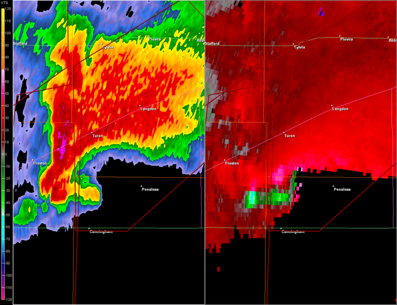
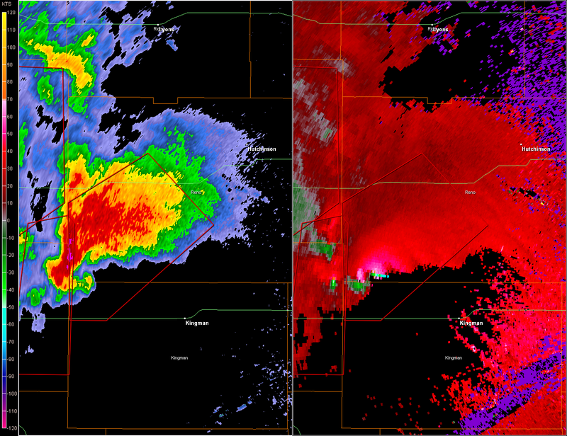
Hutchinson had better watch out for this.
SEVERE WEATHER STATEMENT
NATIONAL WEATHER SERVICE WICHITA KS
1103 PM CDT FRI MAY 23 2008
KSC095-155-240445-
/O.CON.KICT.TO.W.0019.000000T0000Z-080524T0445Z/
RENO KS-KINGMAN KS-
1103 PM CDT FRI MAY 23 2008
...A TORNADO WARNING REMAINS IN EFFECT FOR NORTHWESTERN KINGMAN AND
SOUTHWESTERN RENO COUNTIES UNTIL 1145 PM CDT...
AT 1101 PM CDT...NATIONAL WEATHER SERVICE METEOROLOGISTS CONTINUED TO
TRACK A SEVERE THUNDERSTORM CAPABLE OF PRODUCING A TORNADO. DOPPLER
RADAR WAS INDICATING VERY STRONG ROTATION WITH THIS STORM. THIS
TORNADO WAS LOCATED NEAR CUNNINGHAM...OR 16 MILES EAST OF
PRATT...MOVING NORTHEAST AT 33 MPH. THIS STORM HAS HAD A HISTORY OF
PRODUCING TORNADOES IN PRATT COUNTY.
THE TORNADO WILL BE...
NEAR TURON BY 1110 PM CDT.
NEAR ARLINGTON BY 1135 PM CDT.
NEAR ABBYVILLE BY 1140 PM CDT.
THE TOWNS OF LANGDON AND PLEVNA ARE ALSO IN THE PATH OF THIS TORNADO.THE SAFEST PLACE TO BE DURING A TORNADO IS IN A BASEMENT. GET UNDER A
WORKBENCH OR OTHER PIECE OF STURDY FURNITURE. IF NO BASEMENT IS
AVAILABLE...SEEK SHELTER ON THE LOWEST FLOOR OF THE BUILDING IN AN
INTERIOR HALLWAY OR ROOM SUCH AS A CLOSET. USE BLANKETS OR PILLOWS TO
COVER YOUR BODY AND ALWAYS STAY AWAY FROM WINDOWS.
IF IN MOBILE HOMES OR VEHICLES...EVACUATE THEM AND GET INSIDE A
SUBSTANTIAL SHELTER. IF NO SHELTER IS AVAILABLE...LIE FLAT IN THE
NEAREST DITCH OR OTHER LOW SPOT AND COVER YOUR HEAD WITH YOUR HANDS.
A TORNADO WATCH REMAINS IN EFFECT UNTIL 400 AM CDT SATURDAY MORNING
FOR SOUTH CENTRAL KANSAS.
LAT...LON 3764 9846 3792 9847 3804 9823 3787 9803
3764 9835
TIME...MOT...LOC 0403Z 219DEG 29KT 3772 9844
$$
BOWMAN
0 likes
-
CrazyC83
- Professional-Met
- Posts: 34315
- Joined: Tue Mar 07, 2006 11:57 pm
- Location: Deep South, for the first time!
MESOSCALE DISCUSSION 0994
NWS STORM PREDICTION CENTER NORMAN OK
1114 PM CDT FRI MAY 23 2008
AREAS AFFECTED...PARTS OF WRN NEB
CONCERNING...TORNADO WATCH 343...
VALID 240414Z - 240515Z
THE SEVERE WEATHER THREAT FOR TORNADO WATCH 343 CONTINUES.
WW 343 WILL LIKELY BE ALLOWED TO EXPIRE AT 06Z. TSTMS SHOULD
PERSIST OVERNIGHT ACROSS THIS REGION...BUT OVERALL SEVERE WEATHER
THREAT WILL BE LOW.
50 KT SELY LOW LEVEL WINDS EXTENDING INTO WRN NEB BENEATH DIFFLUENT
MID-UPPER LEVEL FLOW REGIME LOCATED DOWNSTREAM OF SHORT WAVE TROUGH
TRACKING NWD THROUGH ERN CO/KS WILL MAINTAIN DEEP LAYER ASCENT FOR
ADDITIONAL TSTM DEVELOPMENT OVERNIGHT. ALTHOUGH AIR MASS IS
MARGINALLY UNSTABLE ACROSS THE REMAINDER OF WW 343 AND EWD INTO
CENTRAL NEB...7-7.5 C/KM MID LEVEL LAPSE RATES AND 35-50 KT OF
EFFECTIVE BULK SHEAR SUGGEST A FEW STORMS SHOULD REMAIN CAPABLE OF
BECOMING ORGANIZED WITH AN ATTENDANT THREAT FOR HAIL.
..PETERS.. 05/24/2008
ATTN...WFO...GID...LBF...GLD...CYS...
40350055 40330147 41060199 42200285 42880213 42210139
41690076 41400014 41009938 40729947 40370018
0 likes
-
HarlequinBoy

- Category 5

- Posts: 1400
- Age: 35
- Joined: Wed Nov 29, 2006 1:57 am
- Location: Memphis

-
CrazyC83
- Professional-Met
- Posts: 34315
- Joined: Tue Mar 07, 2006 11:57 pm
- Location: Deep South, for the first time!
Re:
HarlequinBoy wrote:It's kind of weird how everything turned more linear suddenly, with the exception of that nasty looker sw of Hutchison.
It's been fluctuating all day, but it seems the squall line is getting itself back together.
0 likes
-
JonathanBelles
- Professional-Met
- Posts: 11430
- Age: 35
- Joined: Sat Dec 24, 2005 9:00 pm
- Location: School: Florida State University (Tallahassee, FL) Home: St. Petersburg, Florida
- Contact:
Re:
Bunkertor wrote:51 reports now
the total number for 2007 will be tied today
for tornadoes? either way WOW!!!
0 likes
Re: Re:
fact789 wrote:Bunkertor wrote:51 reports now
the total number for 2007 will be tied today
for tornadoes? either way WOW!!!
Yes - and survey teams for yesterday haven´t finished and yes...for today....hm.
2006 and 2007 numbers will be tied by end of the month.
0 likes
Return to “USA & Caribbean Weather”
Who is online
Users browsing this forum: AnnularCane, wxman22 and 84 guests