I love it. CMC caves as well to the Euro. Nice corridor of beneficial rainfall from SC TX into North TX (DFW region) setting up within the next 5-10 days as predicted.
Definitely should see the SPC tweak those severe outlooks a little further east for the weekend possibly stretching into next week. A lot to track.
Texas Spring 2026
Moderator: S2k Moderators
Forum rules

The posts in this forum are NOT official forecast and should not be used as such. They are just the opinion of the poster and may or may not be backed by sound meteorological data. They are NOT endorsed by any professional institution or STORM2K.
-
txtwister78

- Category 5

- Posts: 2282
- Joined: Wed Jan 30, 2019 12:56 pm
- Location: San Antonio
Re: Texas Spring 2026
1 likes
-
wxman22

- Category 5
- Posts: 2061
- Joined: Mon Jan 30, 2006 12:39 am
- Location: Wichita Falls, TX
- Contact:
Re: Texas Spring 2026
The SPC is now mentioning the possibility of a substantial severe weather event both Sunday and Tuesday.
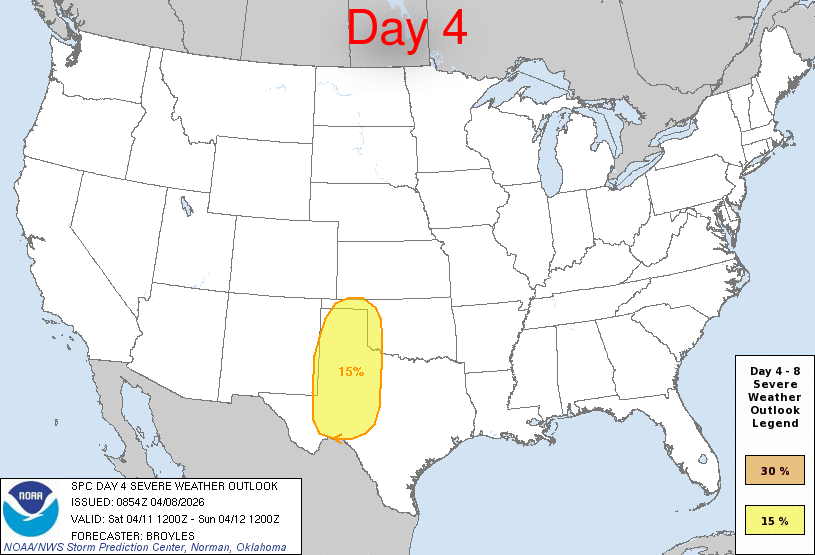
Day 4-8 Convective Outlook
NWS Storm Prediction Center Norman OK
0354 AM CDT Wed Apr 08 2026
Valid 111200Z - 161200Z
...DISCUSSION...
...Saturday/Day 4 to Monday/Day 6...
On Saturday, mid-level southwesterly flow will strengthen over the
central U.S., as an upper-level system moves to near the West Coast.
A moist airmass will be in place over the southern and central
Plains, as a low-amplitude shortwave trough moves across the region.
Large-scale ascent along with warming surface temperatures will
result in scattered thunderstorm development over much of west Texas
Saturday afternoon. MLCAPE is expected to peak near 1000 J/kg in
some areas, with 0-6 km shear being in the 30 to 40 knot range over
much of the southern High Plains. This should be sufficient for a
severe threat, with large hail and severe wind gusts possible.
From Saturday night into Sunday, strong moisture advection is
forecast over the Great Plains. By Sunday afternoon, moderate
instability is expected to be in place over much of this airmass.
Isolated to scattered severe thunderstorms are expected throughout
much of the moist sector during the afternoon and evening. Some
model forecasts move a 50 to 60 knot mid-level jet through central
and northeast Texas during the afternoon and evening. If this
happens, then a substantial severe threat would be possible from
parts of central and north Texas into Oklahoma. Severe storms,
including supercells with large hail, wind damage and a tornado
threat would be possible in areas that destabilize the most.
On Monday, a moist and unstable airmass is forecast to remain from
the southern Plains extending north-northeastward into the Upper
Midwest. Strong to severe thunderstorm development will be possible
over much of the instability corridor in the afternoon and evening.
The greatest potential for severe storms is forecast from the
southern Plains north-northeastward into the lower Missouri Valley
and upper Mississippi Valley, where the models develop moderate
instability and have 0-6 km shear mostly in the 30 to 40 knot range.
Severe storms with large hail, wind damage and a tornado threat will
be possible.
...Tuesday/Day 7 and Wednesday/Day 8...
The western U.S. trough is finally forecast to approach the southern
Plains on Tuesday, where a moist and unstable airmass should be in
place. Some solutions suggest that a mid-level jet will move into
the southern Plains Tuesday afternoon. This would create strong
deep-layer shear over parts of the moist sector, suggesting that a
substantial severe threat will be possible. Although there is still
spatial uncertainty regarding this scenario, current model forecasts
would support supercells with large hail, severe wind gusts and some
tornadoes.
On Wednesday, a shortwave trough is forecast to move through the
central states, with a southwest-to-northeast corridor of moderate
instability in place by afternoon from northeast Texas into western
Ozarks. This would be favorable for severe storms. However, at this
extended range, considerable uncertainty exists concerning severe
threat magnitude and spacing.
..Broyles.. 04/08/2026
0 likes


Re: Texas Spring 2026
Stratton23 wrote:hearing some talk of a “ Super “ El nino event “, ive personally never heard of a Super El nino lol, what would be the difference between a regular el nino and a super one, at least in terms of long term impacts to texas both in the summer and winter?
A Super El Nino is one that reaches +2C above normal in the ENSO 3.4 region for a long period of time. They are the strongest El Ninos and have profound effects years after they terminate, often changing the PDO, creating a new warmer base, and shifting patterns to new regimes. There are only a handful, known is 1877-78, 1982-1983, 1997-1998, and 2015-16. Winters generally are very warm because they flood Canada with warm maritime air more than your typical El Nino but they also feature very strong systems in the winter. They are generally not favorable for cold on a broad scale. However are often associated with periods of very heavy rain throughout the year.
1 likes
The above post and any post by Ntxw is NOT an official forecast and should not be used as such. It is just the opinion of the poster and may or may not be backed by sound meteorological data. It is NOT endorsed by any professional institution including Storm2k. For official information, please refer to NWS products.
Help support Storm2K!
-
TomballEd
- Category 5
- Posts: 1340
- Age: 62
- Joined: Wed Aug 16, 2023 4:52 pm
- Location: Spring/Klein area, not Tomball
Re: Texas Spring 2026
GEFS continue to signal heavy rains for Central Texas and North Texas with less rainfall for STX and SETX. Op Euro from 0Z shows a lot of rain in NETX and SEOK.
0 likes
-
txtwister78
- Category 5
- Posts: 2282
- Joined: Wed Jan 30, 2019 12:56 pm
- Location: San Antonio
Re: Texas Spring 2026
TomballEd wrote:GEFS continue to signal heavy rains for Central Texas and North Texas with less rainfall for STX and SETX. Op Euro from 0Z shows a lot of rain in NETX and SEOK.
Euro Op continues to show SC TX to N TX corridor outside of one run. The ICON and CMC have also trended wetter further south with time. More importantly so have the ensembles.
The GFS continues to be wildly inconsistent. Track record there matters with that model or should.
0 likes
-
txtwister78
- Category 5
- Posts: 2282
- Joined: Wed Jan 30, 2019 12:56 pm
- Location: San Antonio
Re: Texas Spring 2026
6-10 day outlook from CPC and beyond keeps the active pattern ongoing as expected.

4 likes

Re: Texas Spring 2026
Also hearing more chatter about a super Nino. That is good for the state as it’s meant beneficial and drought busting rains in the past.
As far as winter, you can safely bet it will be above average nowadays. El Niño, La Niña, nada… it doesn’t seem to matter, but at least ninos have a better chance of heavy snow (2010 as an example). A foot of snow when the temperature never got below freezing was certainly a site to behold.
As far as winter, you can safely bet it will be above average nowadays. El Niño, La Niña, nada… it doesn’t seem to matter, but at least ninos have a better chance of heavy snow (2010 as an example). A foot of snow when the temperature never got below freezing was certainly a site to behold.
0 likes
-
wxman22
- Category 5
- Posts: 2061
- Joined: Mon Jan 30, 2006 12:39 am
- Location: Wichita Falls, TX
- Contact:
Re: Texas Spring 2026
Tejas89 wrote:Also hearing more chatter about a super Nino. That is good for the state as it’s meant beneficial and drought busting rains in the past.
As far as winter, you can safely bet it will be above average nowadays. El Niño, La Niña, nada… it doesn’t seem to matter, but at least ninos have a better chance of heavy snow (2010 as an example). A foot of snow when the temperature never got below freezing was certainly a site to behold.
Yep, the strong El Niños of 1997 and 2015 both produced cold core snowstorms here.
0 likes
Re: Texas Spring 2026
Here is a composite of the the "Supers" compared to the other El Nino strengths from April to August. They are noticeably wetter. It is interesting the closer you are to the gulf the less influence you will feel, as that is more dependent on tropical activity there.
Supers

Strong

Moderate

Supers
Strong
Moderate
3 likes
The above post and any post by Ntxw is NOT an official forecast and should not be used as such. It is just the opinion of the poster and may or may not be backed by sound meteorological data. It is NOT endorsed by any professional institution including Storm2k. For official information, please refer to NWS products.
Help support Storm2K!
Help support Storm2K!
-
SnowyOwl31

- Tropical Low

- Posts: 10
- Age: 32
- Joined: Mon Feb 02, 2026 4:08 pm
- Location: Texas City, TX
Re: Texas Spring 2026
Interesting, that somewhat supports what I said earlier in this thread about needing tropical activity in the Gulf to get significant rainfall in portions of SE Texas.
0 likes

Re: Texas Spring 2026
SnowyOwl31 wrote:Interesting, that somewhat supports what I said earlier in this thread about needing tropical activity in the Gulf to get significant rainfall in portions of SE Texas.
Maybe a weak sheared TS in June. I’ll take it.
1 likes
-
txtwister78
- Category 5
- Posts: 2282
- Joined: Wed Jan 30, 2019 12:56 pm
- Location: San Antonio
Re: Texas Spring 2026
Nice trend by ICON (similar to EURO and CMC). Dryline surge looks more likely further east as mentioned the other day over the weekend than what the GFS has been showing and so therefore more storms (some severe) into the 35 corridor.
Other good news is some of the hi-res models have begun to align with the Euro giving it more credibility with return moisture and scattered storms tomorrow for deep S TX into SC TX on Friday.
So yes more rain on the way for areas that need it across multiple regions across the state thankfully. Bring it on!
2 likes
-
wxman22
- Category 5
- Posts: 2061
- Joined: Mon Jan 30, 2006 12:39 am
- Location: Wichita Falls, TX
- Contact:
Re: Texas Spring 2026
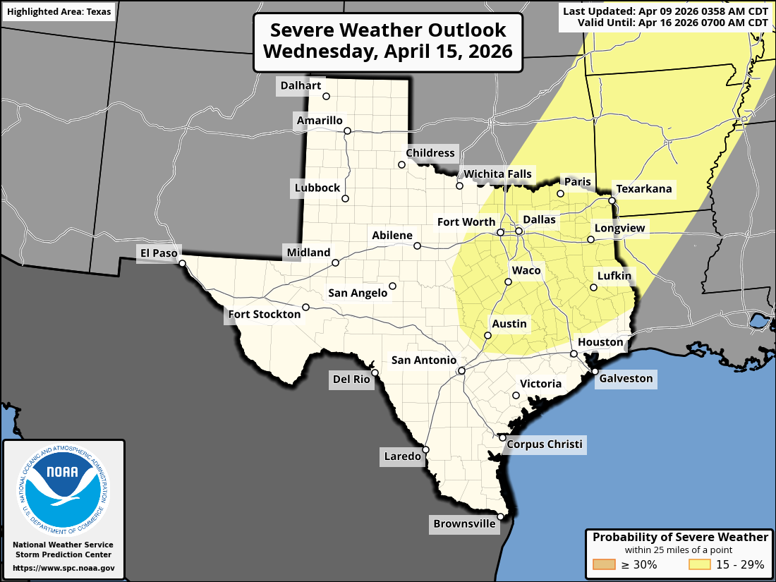
The SPC is still mentioning a substantial risk of severe weather is possible on Tuesday and an upgrade to the risk may happen as confidence increases.
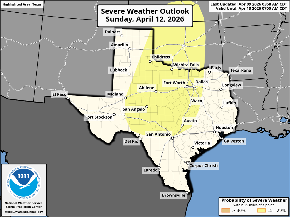
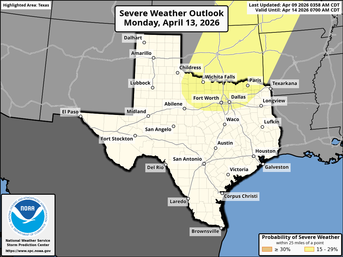
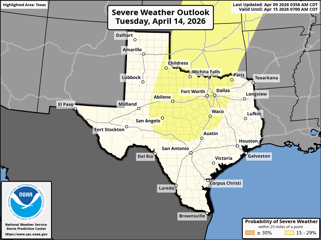
Day 4-8 Convective Outlook
NWS Storm Prediction Center Norman OK
0358 AM CDT Thu Apr 09 2026
Valid 121200Z - 171200Z
...DISCUSSION...
...Sunday/Day 4 to Tuesday/Day 6...
On Sunday, southwesterly mid-level flow will be in place across much
of the nation. At the surface, a moist airmass will be located from
the southern Plains north-northeastward into the Upper Midwest. Much
of this corridor is forecast to become moderately unstable by
afternoon. The greatest potential for severe storms will likely be
in the southern and central Plains, where some solutions have a
subtle shortwave trough. Moderate deep-layer shear and steep lapse
rates will be favorable for supercells with large hail and severe
wind gusts.
Mid-level flow is forecast to gradually strengthen across the
central U.S. on Monday. In response moisture advection will continue
in the Great Plains. By Monday afternoon, moderate instability
should be in place from north Texas northward into the upper
Mississippi Valley. Isolated to scattered thunderstorms are expected
to develop across this airmass Monday afternoon and evening.
Moderate deep-layer shear and steep lapse rates will again be
favorable for severe storms capable of large hail and severe wind
gusts. A tornado threat may also develop.
On Tuesday, an upper-level trough is forecast to move eastward into
the southern Rockies, as an associated mid-level jet streak ejects
northeastward across the southern High Plains. A moderately unstable
airmass will likely be in place by afternoon from the southern
Plains northeastward into mid to upper Mississippi Valley and
southern Great Lakes. Strong deep-layer shear is forecast over the
southern and central Plains, where a substantial severe threat will
be possible. Supercells with large hail, wind damage and tornadoes
are expected Tuesday afternoon and evening. An upgrade will be
possible across parts of the threat area, once confidence increases
on the timing of the ejecting trough.
...Wednesday/Day 7 and Thursday/Day 8...
The upper-level trough is forecast to move eastward across the
central U.S. on Wednesday, as a cold front advances southeastward
through the Great Plains and Upper Midwest. Moderate instability is
forecast to develop ahead of much of the front. Thunderstorms that
form in areas that destabilize sufficiently could have a severe
threat. The severe potential will likely continue into Thursday, as
the front advances southeastward into the mid Mississippi Valley.
However, model spread concerning the position of the front and
timing of the trough increases substantially toward mid week,
suggesting a lot of uncertainty exists at this extended range in the
period.
..Broyles.. 04/09/2026
0 likes
-
TomballEd
- Category 5
- Posts: 1340
- Age: 62
- Joined: Wed Aug 16, 2023 4:52 pm
- Location: Spring/Klein area, not Tomball
Re: Texas Spring 2026
Shelf waters are about 2*C/4*F above normal off SETX. Even when dynamics come closer to SETX, the morning low clouds often linger to noon or later and the cap is never overcome even with help from above. Should be less low clouds, Or I am interested in day 7 severe probs almost to Houston.
My yard gets less rain on two main ops and their ensembles than anyplace but the desert regions and the Panhandle, but if those rains, if they happen every week, would really ease us out of the drought. Hill Country makes up ground fast. Beyond 7 days a signal for flooding rains somewhere (models vary) around the Hill Country, NC Texas and E. Oklahoma remains.
EDIT TO ADD ABOUT THE HILL COUNTRY...
https://x.com/averytomascowx/status/2042239067383894328
0 likes
Re: Texas Spring 2026
-32 daily SOI and looking like the tank continues, MJO is stuck in the El Nino phases loop for spring. The atmosphere is responding to the growing El Nino. First trimonthly should be MJJ, so the idea we get deeper and deeper into El Nino influence the coming days and weeks is intensifying. It's no coincidence every week CPC has slight risk of rainfall in the same areas again and again.
2 likes
The above post and any post by Ntxw is NOT an official forecast and should not be used as such. It is just the opinion of the poster and may or may not be backed by sound meteorological data. It is NOT endorsed by any professional institution including Storm2k. For official information, please refer to NWS products.
Help support Storm2K!
Help support Storm2K!
-
Stratton23
- Category 5
- Posts: 3595
- Joined: Fri Jul 21, 2023 10:59 pm
- Location: Katy, Tx
Re: Texas Spring 2026
Hopefully ridging to our east can weaken significantly, because its really screwing over SE texas in terms of rain chances, hopefully as the influence of el nino grows stronger, ridging will be less of an influence in the weeks ahead
2 likes
-
txtwister78
- Category 5
- Posts: 2282
- Joined: Wed Jan 30, 2019 12:56 pm
- Location: San Antonio
Re: Texas Spring 2026
The 2015 Super El Nino also brought nearly 45 inches of rain to San Antonio as well putting it in the top 10 wettest years on record. Ironically that brought us out of a drought then.
That's why analogs are so important in weather forecasting because you can piece together what likely in some form lies ahead which is why I also mentioned the fall being another period we will have to watch down the road once I saw us headed in this direction. Folks will likely go from being worried about heat waves and perma droughts to concerns about flooding. The data is there. You just have to be willing to look like Avery did obviously with that post above.
In the meantime models continue to align on the prospect of beneficial rainfall from SC TX to N TX. Even far S TX early on in this pattern gets some much needed rain today into tomorrow (scattered). So definitely not limited in scope.
1 likes
-
wxman22
- Category 5
- Posts: 2061
- Joined: Mon Jan 30, 2006 12:39 am
- Location: Wichita Falls, TX
- Contact:
Re: Texas Spring 2026
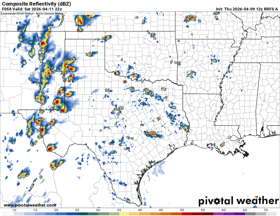
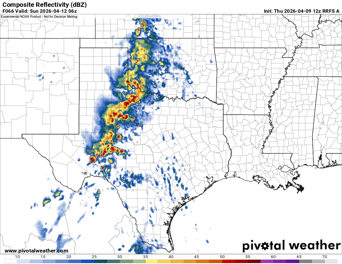
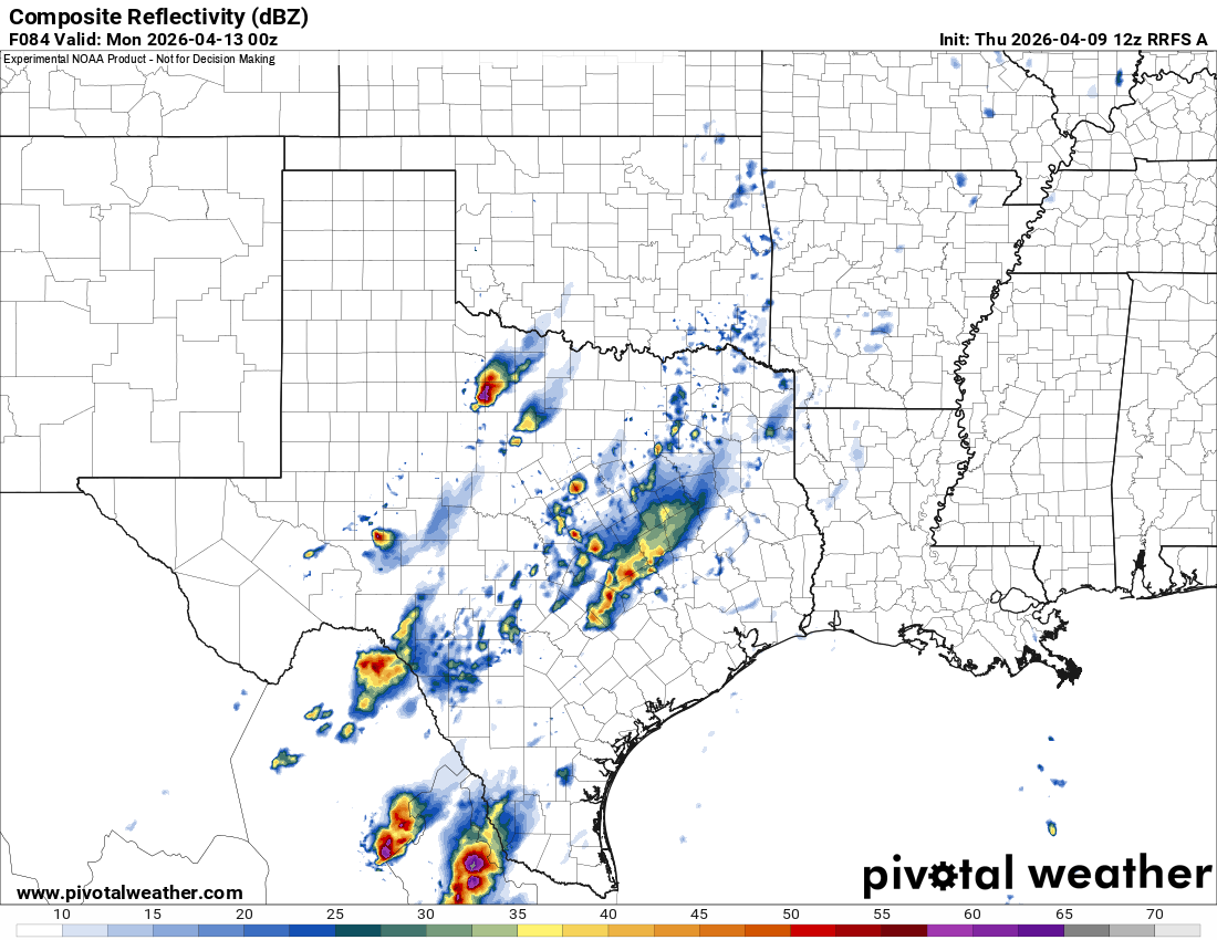
Saturday is getting into range of the CAM’s The RRFS shows supercells developing along the dryline in west Texas and congealing into a MCS overnight. Storms move out fast enough for the atmosphere to recover by Sunday evening. And supercells start to develop again at the end of the run Sunday.
0 likes
-
Iceresistance

- Category 5
- Posts: 9610
- Age: 22
- Joined: Sat Oct 10, 2020 9:45 am
- Location: Tecumseh, OK/Norman, OK
Re: Texas Spring 2026

1 likes
Bill 2015 & Beta 2020
Winter 2020-2021
All observations are in Tecumseh, OK unless otherwise noted.
Winter posts are focused mainly for Oklahoma & Texas.
Take any of my forecasts with a grain of salt, refer to the NWS, SPC, and NHC for official information
Never say Never with weather! Because ANYTHING is possible!
Winter 2020-2021
All observations are in Tecumseh, OK unless otherwise noted.
Winter posts are focused mainly for Oklahoma & Texas.
Take any of my forecasts with a grain of salt, refer to the NWS, SPC, and NHC for official information
Never say Never with weather! Because ANYTHING is possible!
Re: Texas Spring 2026
I would watch the cyclone forming in the WPAC, big sprawling typhoons is signature El Nino in the early season. It has potential to become a very strong recurving typhoon and buckling the north Pacific pattern down the road later in the month and into early May. Perhaps cooler than normal and very heavy rains.
2 likes
The above post and any post by Ntxw is NOT an official forecast and should not be used as such. It is just the opinion of the poster and may or may not be backed by sound meteorological data. It is NOT endorsed by any professional institution including Storm2k. For official information, please refer to NWS products.
Help support Storm2K!
Help support Storm2K!