Yeah those climate models were out in front as mentioned and now Euro in alignment but again with this type of El Nino presentation not surprising.
Happy Easter to all.
Texas Spring 2026
Moderator: S2k Moderators
Forum rules

The posts in this forum are NOT official forecast and should not be used as such. They are just the opinion of the poster and may or may not be backed by sound meteorological data. They are NOT endorsed by any professional institution or STORM2K.
-
txtwister78

- Category 5

- Posts: 2282
- Joined: Wed Jan 30, 2019 12:56 pm
- Location: San Antonio
Re: Texas Spring 2026
1 likes
-
TomballEd
- Category 5
- Posts: 1343
- Age: 62
- Joined: Wed Aug 16, 2023 4:52 pm
- Location: Spring/Klein area, not Tomball
Re: Texas Spring 2026
Hooks had 0.37, IAH an inch. I think my house was closer to the IAH number. I mentioned before there would be SETX winners and losers. Low 60s here but breezy and cool.
Looking ahead, besides severe chances end of the week into the weekend and following weekend, GFS and 0Z Euro have a signal for heavy rains in the Hill Country and maybe NC Texas and SC Texas. That signal has existed for several days

Looking ahead, besides severe chances end of the week into the weekend and following weekend, GFS and 0Z Euro have a signal for heavy rains in the Hill Country and maybe NC Texas and SC Texas. That signal has existed for several days
0 likes
-
TomballEd
- Category 5
- Posts: 1343
- Age: 62
- Joined: Wed Aug 16, 2023 4:52 pm
- Location: Spring/Klein area, not Tomball
Re: Texas Spring 2026
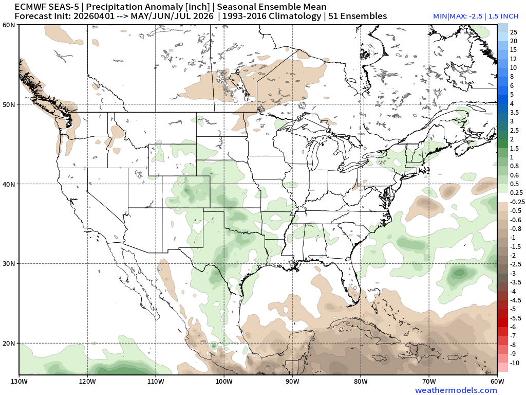
wxman22 wrote:Euro Weeklies for May/June/July. A wet signal is clearly showing up in the Plains. MCS season is probably going to be active this year.
https://i.postimg.cc/g08XYXRG/seas5-qpfa-3mon-conus-MJJ.png
Not to be a turd in the punchbowl but a forecast 3/4" of an inch above the normal over 3 months mean keeps the drought from getting worse, maybe even reduces the category, but it doesn't refill many reservoirs or aquifers. The 'bad water line' of the Edwards has always been close to I-35 (far SE Bexar county is on the salty side of the bad water line), if they pump below the level of the salt water line the freshwater aquifer will start getting salty.
0 likes
-
wxman22

- Category 5
- Posts: 2062
- Joined: Mon Jan 30, 2006 12:39 am
- Location: Wichita Falls, TX
- Contact:
Re: Texas Spring 2026
TomballEd wrote:wxman22 wrote:Euro Weeklies for May/June/July. A wet signal is clearly showing up in the Plains. MCS season is probably going to be active this year.
https://i.postimg.cc/g08XYXRG/seas5-qpfa-3mon-conus-MJJ.png
Not to be a turd in the punchbowl but a forecast 3/4" of an inch above the normal over 3 months mean keeps the drought from getting worse, maybe even reduces the category, but it doesn't refill many reservoirs or aquifers. The 'bad water line' of the Edwards has always been close to I-35 (far SE Bexar county is on the salty side of the bad water line), if they pump below the level of the salt water line the freshwater aquifer will start getting salty.
It's a 3 month mean the signal is supposed to be smoothed out and not taken verbatim.That's not how Anomaly maps work. All you're looking for in this range is whether they show average, below average, or above average anomalies. The exact precip amounts are impossible to decipher this far out.
1 likes

Re: Texas Spring 2026
wxman22 wrote:TomballEd wrote:wxman22 wrote:Euro Weeklies for May/June/July. A wet signal is clearly showing up in the Plains. MCS season is probably going to be active this year.
https://i.postimg.cc/g08XYXRG/seas5-qpfa-3mon-conus-MJJ.png
Not to be a turd in the punchbowl but a forecast 3/4" of an inch above the normal over 3 months mean keeps the drought from getting worse, maybe even reduces the category, but it doesn't refill many reservoirs or aquifers. The 'bad water line' of the Edwards has always been close to I-35 (far SE Bexar county is on the salty side of the bad water line), if they pump below the level of the salt water line the freshwater aquifer will start getting salty.
Its a 3 month mean the signal is supposed to be smoothed out, and not taken verbatim.That's not how Anomaly maps work. All you're looking for in this range is wether they show average, below average, or above average anomalies. The exact precip amounts are impossible to decipher this far out.
Agreed, it’s a pretty good look overall. Hope it verifies. This is the worst drought I’ve had around where I live in a long while.
0 likes
-
TomballEd
- Category 5
- Posts: 1343
- Age: 62
- Joined: Wed Aug 16, 2023 4:52 pm
- Location: Spring/Klein area, not Tomball
Re: Texas Spring 2026
wxman22 wrote:TomballEd wrote:wxman22 wrote:Euro Weeklies for May/June/July. A wet signal is clearly showing up in the Plains. MCS season is probably going to be active this year.
https://i.postimg.cc/g08XYXRG/seas5-qpfa-3mon-conus-MJJ.png
Not to be a turd in the punchbowl but a forecast 3/4" of an inch above the normal over 3 months mean keeps the drought from getting worse, maybe even reduces the category, but it doesn't refill many reservoirs or aquifers. The 'bad water line' of the Edwards has always been close to I-35 (far SE Bexar county is on the salty side of the bad water line), if they pump below the level of the salt water line the freshwater aquifer will start getting salty.
It's a 3 month mean the signal is supposed to be smoothed out and not taken verbatim.That's not how Anomaly maps work. All you're looking for in this range is whether they show average, below average, or above average anomalies. The exact precip amounts are impossible to decipher this far out.
I get that, but the mean being barely above average means more than a few ensemble members are below average or that is essentially a forecast of normal rainfall for most of STX. It is the right three months to be average but a darker shade of green would be better.
0 likes
-
txtwister78
- Category 5
- Posts: 2282
- Joined: Wed Jan 30, 2019 12:56 pm
- Location: San Antonio
Re: Texas Spring 2026
TomballEd wrote:wxman22 wrote:TomballEd wrote:
Not to be a turd in the punchbowl but a forecast 3/4" of an inch above the normal over 3 months mean keeps the drought from getting worse, maybe even reduces the category, but it doesn't refill many reservoirs or aquifers. The 'bad water line' of the Edwards has always been close to I-35 (far SE Bexar county is on the salty side of the bad water line), if they pump below the level of the salt water line the freshwater aquifer will start getting salty.
It's a 3 month mean the signal is supposed to be smoothed out and not taken verbatim.That's not how Anomaly maps work. All you're looking for in this range is whether they show average, below average, or above average anomalies. The exact precip amounts are impossible to decipher this far out.
I get that, but the mean being barely above average means more than a few ensemble members are below average or that is essentially a forecast of normal rainfall for most of STX. It is the right three months to be average but a darker shade of green would be better.
I think the overall signal and that's what these long range outlooks represent at this stage in time should be viewed as a positive one for our state. More importantly it fits the type of El Nino we're transitioning into from an analog perspective and so it's not just about the output but the background support that exist which gives those forecast more credibility
Again I'm going to keep repeating this but it's important given the current state of our drought conditions along with the absolutely brutal dry summers we've had over the past several years and that is how can one look at these outlooks (climate and now euro seasonal) as anything but positive considering the alternative??? Lol
Obviously no need to figure it all out now in terms of guessing on total amounts or get into the weeds just yet regarding "how much above normal" we actually end up. The point is what would we all be saying absent those signals headed into the summer withva drought in place? So let's see how it all plays out but I'm just as optimistic as I was in March about the prospects in April and here we are.
2 likes


Re: Texas Spring 2026
txtwister78 wrote:TomballEd wrote:wxman22 wrote:
It's a 3 month mean the signal is supposed to be smoothed out and not taken verbatim.That's not how Anomaly maps work. All you're looking for in this range is whether they show average, below average, or above average anomalies. The exact precip amounts are impossible to decipher this far out.
I get that, but the mean being barely above average means more than a few ensemble members are below average or that is essentially a forecast of normal rainfall for most of STX. It is the right three months to be average but a darker shade of green would be better.
I think the overall signal and that's what these long range outlooks represent at this stage in time should be viewed as a positive one for our state. More importantly it fits the type of El Nino we're transitioning into from an analog perspective and so it's not just about the output but the background support that exist which gives those forecast more credibility
Again I'm going to keep repeating this but it's important given the current state of our drought conditions along with the absolutely brutal dry summers we've had over the past several years and that is how can one look at these outlooks (climate and now euro seasonal) as anything but positive considering the alternative??? Lol
Obviously no need to figure it all out now in terms of guessing on total amounts or get into the weeds just yet regarding "how much above normal" we actually end up. The point is what would we all be saying absent those signals headed into the summer withva drought in place? So let's see how it all plays out but I'm just as optimistic as I was in March about the prospects in April and here we are.
Yeah the alternative is they show above normal heights, above normal temps, and below normal precipitation which is what they have been showing for years season after season. It's a good sign, beggars can't be choosers. El Nino usually has a year, either of or the next year, that rainfall is pretty good.
4 likes
The above post and any post by Ntxw is NOT an official forecast and should not be used as such. It is just the opinion of the poster and may or may not be backed by sound meteorological data. It is NOT endorsed by any professional institution including Storm2k. For official information, please refer to NWS products.
Help support Storm2K!
-
txtwister78
- Category 5
- Posts: 2282
- Joined: Wed Jan 30, 2019 12:56 pm
- Location: San Antonio
Re: Texas Spring 2026
Ntxw wrote:txtwister78 wrote:TomballEd wrote:
I get that, but the mean being barely above average means more than a few ensemble members are below average or that is essentially a forecast of normal rainfall for most of STX. It is the right three months to be average but a darker shade of green would be better.
I think the overall signal and that's what these long range outlooks represent at this stage in time should be viewed as a positive one for our state. More importantly it fits the type of El Nino we're transitioning into from an analog perspective and so it's not just about the output but the background support that exist which gives those forecast more credibility
Again I'm going to keep repeating this but it's important given the current state of our drought conditions along with the absolutely brutal dry summers we've had over the past several years and that is how can one look at these outlooks (climate and now euro seasonal) as anything but positive considering the alternative??? Lol
Obviously no need to figure it all out now in terms of guessing on total amounts or get into the weeds just yet regarding "how much above normal" we actually end up. The point is what would we all be saying absent those signals headed into the summer withva drought in place? So let's see how it all plays out but I'm just as optimistic as I was in March about the prospects in April and here we are.
Yeah the alternative is they show above normal heights, above normal temps, and below normal precipitation which is what they have been showing for years season after season. It's a good sign, beggars can't be choosers. El Nino usually has a year, either of or the next year, that rainfall is pretty good.
Exactly!
0 likes
Re: Texas Spring 2026
The GFS and Euro are worlds apart. I’m not believing anything past 3 days out.
0 likes
-
Iceresistance

- Category 5
- Posts: 9610
- Age: 22
- Joined: Sat Oct 10, 2020 9:45 am
- Location: Tecumseh, OK/Norman, OK
Re: Texas Spring 2026
Cpv17 wrote:The GFS and Euro are worlds apart. I’m not believing anything past 3 days out.
For this kind of range, I prefer ensemble forecasting, but even that has agreement issues
0 likes
Bill 2015 & Beta 2020
Winter 2020-2021
All observations are in Tecumseh, OK unless otherwise noted.
Winter posts are focused mainly for Oklahoma & Texas.
Take any of my forecasts with a grain of salt, refer to the NWS, SPC, and NHC for official information
Never say Never with weather! Because ANYTHING is possible!
Winter 2020-2021
All observations are in Tecumseh, OK unless otherwise noted.
Winter posts are focused mainly for Oklahoma & Texas.
Take any of my forecasts with a grain of salt, refer to the NWS, SPC, and NHC for official information
Never say Never with weather! Because ANYTHING is possible!
Re: Texas Spring 2026
Iceresistance wrote:Cpv17 wrote:The GFS and Euro are worlds apart. I’m not believing anything past 3 days out.
For this kind of range, I prefer ensemble forecasting, but even that has agreement issues
I’ve noticed that as well.
0 likes
-
Iceresistance
- Category 5
- Posts: 9610
- Age: 22
- Joined: Sat Oct 10, 2020 9:45 am
- Location: Tecumseh, OK/Norman, OK
Re: Texas Spring 2026
Cpv17 wrote:Iceresistance wrote:Cpv17 wrote:The GFS and Euro are worlds apart. I’m not believing anything past 3 days out.
For this kind of range, I prefer ensemble forecasting, but even that has agreement issues
I’ve noticed that as well.
I will mention that the euro has been starting to become more and more aggressive with the setups later down the road, so maybe it's caving to the GFS/GEFS?
0 likes
Bill 2015 & Beta 2020
Winter 2020-2021
All observations are in Tecumseh, OK unless otherwise noted.
Winter posts are focused mainly for Oklahoma & Texas.
Take any of my forecasts with a grain of salt, refer to the NWS, SPC, and NHC for official information
Never say Never with weather! Because ANYTHING is possible!
Winter 2020-2021
All observations are in Tecumseh, OK unless otherwise noted.
Winter posts are focused mainly for Oklahoma & Texas.
Take any of my forecasts with a grain of salt, refer to the NWS, SPC, and NHC for official information
Never say Never with weather! Because ANYTHING is possible!
Re: Texas Spring 2026
Iceresistance wrote:Cpv17 wrote:Iceresistance wrote:
For this kind of range, I prefer ensemble forecasting, but even that has agreement issues
I’ve noticed that as well.
I will mention that the euro has been starting to become more and more aggressive with the setups later down the road, so maybe it's caving to the GFS/GEFS?
Maybe. I noticed that on X people are freaking out on severe weather potential from the latest run of the GFS.
0 likes
-
Brent
- S2K Supporter

- Posts: 38790
- Age: 37
- Joined: Sun May 16, 2004 10:30 pm
- Location: Tulsa Oklahoma
- Contact:
Re: Texas Spring 2026
Cpv17 wrote:Iceresistance wrote:Cpv17 wrote:
I’ve noticed that as well.
I will mention that the euro has been starting to become more and more aggressive with the setups later down the road, so maybe it's caving to the GFS/GEFS?
Maybe. I noticed that on X people are freaking out on severe weather potential from the latest run of the GFS.
Oh the usual suspects are already hyping here. I'm like guys it's about to be 70s and sunny the next 3-4 days. Relax. We'll be wishing for this weeks weather in a few months
I'm not gonna worry about it too far out
0 likes
#neversummer
-
HockeyTx82
- S2K Supporter
- Posts: 2830
- Joined: Tue Oct 27, 2009 11:17 am
- Location: Ponder, TX
Re: Texas Spring 2026
Brent wrote:Cpv17 wrote:Iceresistance wrote:I will mention that the euro has been starting to become more and more aggressive with the setups later down the road, so maybe it's caving to the GFS/GEFS?
Maybe. I noticed that on X people are freaking out on severe weather potential from the latest run of the GFS.
Oh the usual suspects are already hyping here. I'm like guys it's about to be 70s and sunny the next 3-4 days. Relax. We'll be wishing for this weeks weather in a few months
I'm not gonna worry about it too far out
Well as of this moring there's a 15% risk for Saturday and Sunday for a good chunk of Texas. Get the hype machines cranked up.
0 likes
Don't hold me accountable for anything I post on this forum. Leave the real forecasting up to the professionals.
Location: Ponder, TX (all observation posts are this location unless otherwise noted)
Location: Ponder, TX (all observation posts are this location unless otherwise noted)
-
wxman22
- Category 5
- Posts: 2062
- Joined: Mon Jan 30, 2006 12:39 am
- Location: Wichita Falls, TX
- Contact:
Re: Texas Spring 2026
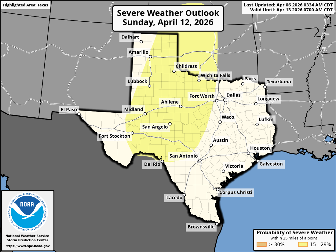
Day 4-8 Convective Outlook
NWS Storm Prediction Center Norman OK
0334 AM CDT Mon Apr 06 2026
Valid 091200Z - 141200Z
...DISCUSSION...
...Thursday/Day 4 to Saturday/Day 6...
From Thursday to Saturday, mid-level flow over the south-central
U.S. is forecast to gradually transition from westerly to
southwesterly. In response, low-level moisture advection will likely
take place in the southern and central Plains. Isolated severe
storms will be possible near a front in the central Plains from late
Thursday afternoon into the early overnight period, as a low-level
jet strengthens. On Friday, weak instability is forecast to develop
over much of the southern Plains. Isolated to scattered
thunderstorms will be possible in the afternoon and evening across
parts of this airmass. An isolated severe threat may develop in some
areas, but deep-layer shear is forecast to be relatively weak over
much of the southern Plains, suggesting a more localized severe
potential.
On Saturday, the potential for severe storms is expected to increase
over parts of southern High Plains, as mid-level southwesterly flow
strengthens. Model consensus suggests that the greatest severe
threat potential will be over parts of west Texas, where some models
have an axis of moderate instability in place by late Saturday
afternoon. Supercells with large hail and severe wind gusts will be
possible in the afternoon and evening, with storms that develop near
this instability axis.
...Sunday/Day 7 and Monday/Day 8...
On Sunday, an upper-level low and an associated trough is forecast
to move eastward across the Desert Southwest and northern Mexico.
Ahead of this trough, moderate instability is forecast to develop by
Sunday afternoon over much of the southern High Plains. Scattered
severe storms would be possible to the east of a west Texas dryline
in the afternoon and evening. A severe threat should continue into
the overnight as a low-level jet strengthens ahead of the
approaching trough.
On Monday, the upper-level trough is forecast to move quickly
northeastward across the central U.S, with an axis of moisture and
instability located in the Great Plains. Scattered severe storms
will be possible from Monday into Monday night from the southern
Plains northward into Upper Midwest. At this extended range, there
is still considerable uncertainty concerning the timing of the
trough. For this reason, will hold off on a threat area until the
models show better agreement.
0 likes
-
Brent
- S2K Supporter
- Posts: 38790
- Age: 37
- Joined: Sun May 16, 2004 10:30 pm
- Location: Tulsa Oklahoma
- Contact:
Re: Texas Spring 2026
HockeyTx82 wrote:Brent wrote:Cpv17 wrote:
Maybe. I noticed that on X people are freaking out on severe weather potential from the latest run of the GFS.
Oh the usual suspects are already hyping here. I'm like guys it's about to be 70s and sunny the next 3-4 days. Relax. We'll be wishing for this weeks weather in a few months
I'm not gonna worry about it too far out
Well as of this moring there's a 15% risk for Saturday and Sunday for a good chunk of Texas. Get the hype machines cranked up.
And the complaints about the weekend being rained out have already started
 people are never happy here
 It's usually overnight here anyway
0 likes
#neversummer
-
TomballEd
- Category 5
- Posts: 1343
- Age: 62
- Joined: Wed Aug 16, 2023 4:52 pm
- Location: Spring/Klein area, not Tomball
Re: Texas Spring 2026
Chilly just now standing in the shade for a fire drill. Good news this is my conference period and I had no students.
Last chilly morning of the year?
Last chilly morning of the year?
0 likes
Return to “USA & Caribbean Weather”
Who is online
Users browsing this forum: mmmmsnouts, TomballEd and 70 guests