

I saw the Jarrell tornado first hand. Cured me of ever wanting to be a chaser. Was in a Walmart when the power went out and that thing went by. Total pandemonium. Went to get on the freeway and everyone was stopped to look. Didn't even know the toll until I got home.
Video probably doesn't do any tornado justice but nothing I've seen since has depicted the power and enormity of the Jarrell tornado. Just looking at it sit and spin and you knew everything under it was being ground to dust.
Texas Spring 2017
Moderator: S2k Moderators
Forum rules

The posts in this forum are NOT official forecast and should not be used as such. They are just the opinion of the poster and may or may not be backed by sound meteorological data. They are NOT endorsed by any professional institution or STORM2K.
Re: Texas Spring 2017
1 likes


Re: Texas Spring 2017
PDO for March rose a little bit. This is good news for rain, April looks like it's on the way up also. Nino or not we still have the +PDO on our camp. That's the silver lining since 2014, since the PDO flip in 2014 drought has been unable to make a stay for any good length of time.
Most recent rainfall did a good number on the short term drought along I-20

Also look at California! Not too long ago they were basically where we were in 2011-2012, nearly wiped out the drought to date. The Pacific has had quite a say in both events.

Most recent rainfall did a good number on the short term drought along I-20
Also look at California! Not too long ago they were basically where we were in 2011-2012, nearly wiped out the drought to date. The Pacific has had quite a say in both events.
2 likes
The above post and any post by Ntxw is NOT an official forecast and should not be used as such. It is just the opinion of the poster and may or may not be backed by sound meteorological data. It is NOT endorsed by any professional institution including Storm2k. For official information, please refer to NWS products.
Help support Storm2K!
-
weatherdude1108
- Category 5

- Posts: 4228
- Joined: Tue Dec 13, 2011 1:04 pm
- Location: Northwest Austin/Cedar Park, TX
Re: Texas Spring 2017
Looking good!  I guess I won't run my sprinklers tomorrow.

2 likes
The preceding post is NOT an official forecast, and should not be used as such. It is only the opinion of the poster and may or may not be backed by sound meteorological data. It is NOT endorsed by any professional institution including storm2k.org. For Official Information please refer to the NHC and NWS products.
-
bubba hotep

- S2K Supporter

- Posts: 6014
- Joined: Wed Dec 28, 2016 1:00 am
- Location: Collin County Texas
Re: Texas Spring 2017
The models have shifted back to the NW with the axis of heaviest rainfall for early next week after having steadily shifted it SE. Looks like potentially pretty good totals coming for DFW.
1 likes
Winter time post are almost exclusively focused on the DFW area.
-
bubba hotep
- S2K Supporter
- Posts: 6014
- Joined: Wed Dec 28, 2016 1:00 am
- Location: Collin County Texas
Re: Texas Spring 2017
SPC taking a look at Monday

1 likes
Winter time post are almost exclusively focused on the DFW area.
Re: Texas Spring 2017
CPC certainly agrees on wetter period

1 likes
The above post and any post by Ntxw is NOT an official forecast and should not be used as such. It is just the opinion of the poster and may or may not be backed by sound meteorological data. It is NOT endorsed by any professional institution including Storm2k. For official information, please refer to NWS products.
Help support Storm2K!
Help support Storm2K!
-
weatherdude1108
- Category 5
- Posts: 4228
- Joined: Tue Dec 13, 2011 1:04 pm
- Location: Northwest Austin/Cedar Park, TX
Re: Texas Spring 2017
Highest QPFs in the drier regions of Texas. El Ninoesque HP Supercells maybe(?).
1 likes
The preceding post is NOT an official forecast, and should not be used as such. It is only the opinion of the poster and may or may not be backed by sound meteorological data. It is NOT endorsed by any professional institution including storm2k.org. For Official Information please refer to the NHC and NWS products.
-
weatherdude1108
- Category 5
- Posts: 4228
- Joined: Tue Dec 13, 2011 1:04 pm
- Location: Northwest Austin/Cedar Park, TX
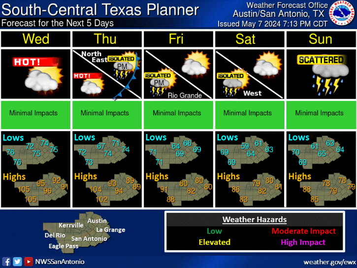
Re: Texas Spring 2017
Area Forecast Discussion
National Weather Service Austin/San Antonio TX
250 PM CDT Fri Apr 7 2017
.SHORT TERM (Tonight through Saturday Night)...
Mostly clear skies continue to prevail across South-Central Texas
with temperatures in the middle to upper 70s areawide. Southerly
winds are in the 10 to 15 MPH range with higher gusts as southerly
flow increases across the Plains. The short-term forecast is expected
to remain pretty quiet with a nearly persistence forecast expected
as mid-level ridging remains in place. Should see a return of
nocturnal stratus Saturday night with some possible drizzle across
the Hill Country where low-level lift up the escarpment is expected
to be strongest. Low temperatures tonight and Saturday night will be
in the 50s and 60s respectively. Highs Saturday will top out in the
lower 80s to lower 90s.
&&
.LONG TERM (Sunday through Friday)...
Changes will be beginning to occur for the start of the long-term
forecast as an upper trough begins to move into the western CONUS.
This trough will shift the Central Plains ridge east to allow for the
decent chance of showers and thunderstorms back into the forecast.
The main dynamics associated with the upper trough will pass north of
the area but the system will send a cold front south into the region
on Monday. At the same time, a weak disturbance embedded in the
southwest flow will allow for thunderstorm development along the
boundary Monday afternoon. This should initially occur just north of
the CWA, but this activity should move south into the area by the
late afternoon hours. The convective environment of should have CAPE
values less than 2,000 J/kg, but shear profiles could support a
couple of severe multicellular clusters with large hail and damaging
winds being the initial main threat. Models are in fairly good
agreement that a large area of showers and storms will move south and
affect much of the CWA late Monday afternoon and overnight. The main
threat with this activity will shift to a locally heavy rainfall
threat.
Another disturbance will move into the region Tuesday and will likely
allow for additional scattered to numerous shower and storm
development, especially if there are residual outflow boundaries left
from the Monday activity. Upper ridging moves into the area on
Wednesday, but models still show that with afternoon heating, 20 to
30 PoPs are warranted for the forecast. Slightly lower PoPs are in
the forecast for the rest of the long-term as uncertainties in the
extended remain. Rainfall in the extended will likely average 1-3
inches with isolated locations possibly reaching 5+ inches.
1 likes
The preceding post is NOT an official forecast, and should not be used as such. It is only the opinion of the poster and may or may not be backed by sound meteorological data. It is NOT endorsed by any professional institution including storm2k.org. For Official Information please refer to the NHC and NWS products.

Re: Texas Spring 2017
Won't be needing my rain machine if projected rainfall amounts come to pass. 
2 likes
Resident Rain Miser
I am a weather hobbyist living 3.5 miles south of Downtown Austin and in no way or fashion should anything I say concerning forecasts be taken seriously. Please check your local NWS for accurate weather forecasting and conditions.
I am a weather hobbyist living 3.5 miles south of Downtown Austin and in no way or fashion should anything I say concerning forecasts be taken seriously. Please check your local NWS for accurate weather forecasting and conditions.
-
weatherdude1108
- Category 5
- Posts: 4228
- Joined: Tue Dec 13, 2011 1:04 pm
- Location: Northwest Austin/Cedar Park, TX
Re: Texas Spring 2017
JDawg512 wrote:Won't be needing my rain machine if projected rainfall amounts come to pass.
No sir, you will not be needing the rain machine.
Zach Shields on FOX 7 Weather always talks about the "rain machine" on his forecasts.
0 likes
The preceding post is NOT an official forecast, and should not be used as such. It is only the opinion of the poster and may or may not be backed by sound meteorological data. It is NOT endorsed by any professional institution including storm2k.org. For Official Information please refer to the NHC and NWS products.
-
bubba hotep
- S2K Supporter
- Posts: 6014
- Joined: Wed Dec 28, 2016 1:00 am
- Location: Collin County Texas
Re: Texas Spring 2017
It looks like the Pacific might finally be about to start the shift away from neutral and towards El Nino. This might be why the longer range models are so wet heading out beyond Week 2.
https://twitter.com/whatisthisrds/status/850544284499685377
https://twitter.com/whatisthisrds/status/850544284499685377
2 likes
Winter time post are almost exclusively focused on the DFW area.
-
bubba hotep
- S2K Supporter
- Posts: 6014
- Joined: Wed Dec 28, 2016 1:00 am
- Location: Collin County Texas
Re: Texas Spring 2017
Great image from Brian Brettschneider. Most people that I know outside of Texas only think drought and Houston flooding. But overall, Texas is pretty good for heavy rain lovers.

2 likes
Winter time post are almost exclusively focused on the DFW area.
-
Brent
- S2K Supporter
- Posts: 38755
- Age: 37
- Joined: Sun May 16, 2004 10:30 pm
- Location: Tulsa Oklahoma
- Contact:
Re: Texas Spring 2017
apparently sirens going off countywide in Dallas weird...
DFW Scanner @DFWscanner 2m2 minutes ago
More
More reports of the outdoor warning sirens sounding across portions of Dallas and even Collin Counties. Are you hearing them, & from where?
DFW Scanner @DFWscanner 2m2 minutes ago
More
More reports of the outdoor warning sirens sounding across portions of Dallas and even Collin Counties. Are you hearing them, & from where?
0 likes
#neversummer
-
bubba hotep
- S2K Supporter
- Posts: 6014
- Joined: Wed Dec 28, 2016 1:00 am
- Location: Collin County Texas
Re: Texas Spring 2017
Brent wrote:apparently sirens going off countywide in Dallas weird...
DFW Scanner @DFWscanner 2m2 minutes ago
More
More reports of the outdoor warning sirens sounding across portions of Dallas and even Collin Counties. Are you hearing them, & from where?
Apparently it was a false alarm or error

0 likes
Winter time post are almost exclusively focused on the DFW area.
-
aggiecutter
- Category 5
- Posts: 1755
- Joined: Thu Oct 14, 2004 9:22 pm
- Location: Texarkana
Re: Texas Spring 2017
Joe BastardiVerified account
@BigJoeBastardi
Following
More
Euro seasonal have another hot US Summer (we have that) but argument as where its hottest. US warmer than normal seasonal streak continues!
@BigJoeBastardi
Following
More
Euro seasonal have another hot US Summer (we have that) but argument as where its hottest. US warmer than normal seasonal streak continues!
0 likes
-
TeamPlayersBlue

- Category 5
- Posts: 3531
- Joined: Tue Feb 02, 2010 1:44 am
- Location: Denver/Applewood, CO
Re: Texas Spring 2017
Solid map above lol. Yeah, lots of those days around here. So many during these El nino years of late. Can think of about 5 days in the 99th percentile within the last 4 years. Probably has actually been closer to 10 though.
0 likes
Personal Forecast Disclaimer:
The posts in this forum are NOT official forecast and should not be used as such. They are just the opinion of the poster and may or may not be backed by sound meteorological data. They are NOT endorsed by any professional institution or storm2k.org. For official information, please refer to the NHC and NWS products.
The posts in this forum are NOT official forecast and should not be used as such. They are just the opinion of the poster and may or may not be backed by sound meteorological data. They are NOT endorsed by any professional institution or storm2k.org. For official information, please refer to the NHC and NWS products.
-
Brent
- S2K Supporter
- Posts: 38755
- Age: 37
- Joined: Sun May 16, 2004 10:30 pm
- Location: Tulsa Oklahoma
- Contact:
Re: Texas Spring 2017
bubba hotep wrote:Brent wrote:apparently sirens going off countywide in Dallas weird...
DFW Scanner @DFWscanner 2m2 minutes ago
More
More reports of the outdoor warning sirens sounding across portions of Dallas and even Collin Counties. Are you hearing them, & from where?
Apparently it was a false alarm or error
Apparently they were hacked...

Dallas city officials said Saturday that a hacker is to blame for setting off all the city's 156 emergency outdoor sirens, which wailed for an hour and half overnight.
0 likes
#neversummer
-
bubba hotep
- S2K Supporter
- Posts: 6014
- Joined: Wed Dec 28, 2016 1:00 am
- Location: Collin County Texas
Re: Texas Spring 2017
Looks like a tricky setup for next Monday/Tuesday but someone is going to get a lot of rain!
0 likes
Winter time post are almost exclusively focused on the DFW area.

Re: Texas Spring 2017
Where does the front stall, that's the question on where some of the big totals will come from.
0 likes
Re: Texas Spring 2017
DonWrk wrote:Where does the front stall, that's the question on where some of the big totals will come from.
Closest to the stalled front could see 2-5" of rain most likely, which consensus at the moment is slightly southeast of DFW. North and west of DFW may only see half and inch to an inch with 1-3" for areas in between. Where front is, definitely a key player for focus of training rain.
0 likes
The above post and any post by Ntxw is NOT an official forecast and should not be used as such. It is just the opinion of the poster and may or may not be backed by sound meteorological data. It is NOT endorsed by any professional institution including Storm2k. For official information, please refer to NWS products.
Help support Storm2K!
Help support Storm2K!
Return to “USA & Caribbean Weather”
Who is online
Users browsing this forum: No registered users and 140 guests