Texas Summer - 2013

U.S. & Caribbean Weather Discussions and Severe Weather Events

Moderator: S2k Moderators

Forum rules

The posts in this forum are NOT official forecast and should not be used as such. They are just the opinion of the poster and may or may not be backed by sound meteorological data. They are NOT endorsed by any professional institution or STORM2K.

Help Support Storm2K
Message
Author
weatherdude1108
Category 5
Category 5
Posts: 4179
Joined: Tue Dec 13, 2011 1:04 pm
Location: Northwest Austin/Cedar Park, TX

Re: Texas Summer - 2013

#481 Postby weatherdude1108 » Wed Sep 04, 2013 10:29 am

Portastorm wrote:Man, I don't know where it came from ... but somehow overnight, the PWC picked up an unexpected .10 inches of rain from an overnight storm. Nice little surprise.

BTW, anyone look at the 0z GFS? The 8-16 day period shows 4 1/2 inches of rain for the Austin area. Wish that would come true!


Wow! Isn't that nice? :D I noticed my system showed 0.02-inch. My sprinkler went off (watering day) and thought the gauge got hit, but I checked the tree leaves high above the sprinkler line of fire, and they were wet! 4 1/2 inches would be a taste of heaven, especially if it falls all over the region!
0 likes   

Ntxw
Storm2k Moderator
Storm2k Moderator
Posts: 21566
Joined: Wed Oct 21, 2009 6:34 pm
Location: DFW, Texas

#482 Postby Ntxw » Wed Sep 04, 2013 10:44 am

I am happy for you guys who saw any rain!

It has been a horrible way to end summer. My analogs have failed me in that they pointed to wetter/cooler conditions. The blame goes to the Atlantic, it is as dead as Texas road kill. Not even an El Nino kills the tropics like this in our basin and it essentially has produced little, and even less for Texas. Many hurricane season predictions are going to bust and bust big time. The analogs had it right in that the warmth centers over the US during fall but without the gulf the warmth spreads south.

In lighter news the SOI has gone negative, that is a little hope for us to see better systems from westerlies return later in the month.
0 likes   
The above post and any post by Ntxw is NOT an official forecast and should not be used as such. It is just the opinion of the poster and may or may not be backed by sound meteorological data. It is NOT endorsed by any professional institution including Storm2k. For official information, please refer to NWS products.

  Help support Storm2K!
Help Support Storm2K

User avatar
Rgv20
S2K Supporter
S2K Supporter
Posts: 2458
Age: 37
Joined: Wed Jan 05, 2011 5:42 pm
Location: Edinburg/McAllen Tx

#483 Postby Rgv20 » Wed Sep 04, 2013 12:37 pm

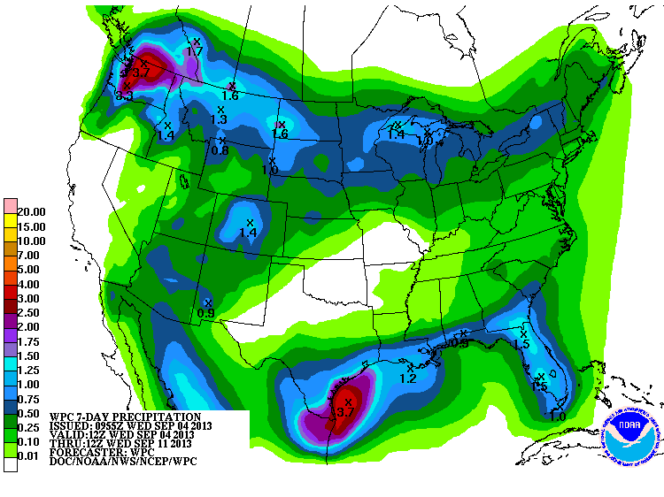
Discussion out of the WPC.....Overall it looks like at least the Southern half of the state its going to get some beneficial Rainfall in the next 5 days! :D 12zGFS continues the wet pattern for Southern Texas in the 5-10 days and 11-15 days range! This could potentially be a very good September down here! :)

EXTENDED FORECAST DISCUSSION
NWS WEATHER PREDICTION CENTER COLLEGE PARK MD
1138 AM EDT WED SEP 04 2013

OVER THE LOWER LATITUDES...POSSIBILITIES REMAIN MORE CHAOTIC SO
PLEASE REFER TO PRODUCTS FROM THE NHC FOR INFORMATION UPDATES ON
ANY POTENTIAL WEATHER FEATURES BEING MONITORED OUT FROM THE
CARIBBEAN AND OFF THE MEXICAN COASTS. HOWEVER...MOISTURE FLOW
DOES SEEM FAVORABLE FOR PCPN POTENTIAL FROM THE FL PENISULA AND
OUT TO THE WRN GULF COAST/SRN TEXAS
ALONG WITH LINGERING MONSOONAL
ACTIVITY UP THROUGH THE SWRN US AND S-CENTRAL GREAT BASIN/ROCKIES
AROUND THE WRN PERIPHERY OF AN AMPLIFIED/WARMING...AND SLOWLY EWD
DRIFTING S-CENTRAL US MID-UPPER LEVEL RIDGE.


HPC forecast Rainfall thru the next 7 days..
Image
0 likes   
The following post is NOT an official forecast and should not be used as such. It is just the opinion of the poster and may or may not be backed by sound meteorological data. It is NOT endorsed by any professional institution including storm2k.org For Official Information please refer to the NHC and NWS products.

User avatar
Rgv20
S2K Supporter
S2K Supporter
Posts: 2458
Age: 37
Joined: Wed Jan 05, 2011 5:42 pm
Location: Edinburg/McAllen Tx

#484 Postby Rgv20 » Wed Sep 04, 2013 2:25 pm

This is a very detailed look from the NWS in Brownsville at the upcoming wet pattern setting up for us in the RGV...http://www.srh.noaa.gov/images/bro/news/2013/pdf/earlyseptemberupdate.pdf

NWS in Brownsville reminding us to keep an eye on the Tropics..

Keep in Mind:Despite the very slow ramp up to the middle of the 2013 season, never forget Beulah,which ravaged the RGV September 20-22, 1967. The expected pattern evolution, should it continue through late September, could open the door to any wave that develops in the western Caribbean to move toward the northwest Gulf. Texas’ hurricane season doesn’t typically end until the first “real” cold front sweeps through, usually by early to mid-October. Bottom Line: Stay Prepared and Aware!
0 likes   
The following post is NOT an official forecast and should not be used as such. It is just the opinion of the poster and may or may not be backed by sound meteorological data. It is NOT endorsed by any professional institution including storm2k.org For Official Information please refer to the NHC and NWS products.

User avatar
South Texas Storms
Professional-Met
Professional-Met
Posts: 4041
Joined: Thu Jun 24, 2010 12:28 am
Location: Houston, TX

Re: Texas Summer - 2013

#485 Postby South Texas Storms » Wed Sep 04, 2013 4:40 pm

Here is my latest weather article! I hope all of us can get some much needed rainfall in the next 7 days! http://www.examiner.com/article/scatter ... -next-week
0 likes   

User avatar
Nikki
S2K Supporter
S2K Supporter
Posts: 291
Joined: Mon Jun 21, 2010 3:38 pm
Location: Santa Fe, TX (yes I typed that right TEXAS not New Mexico, I am about 20 miles from Galveston, TX)

Re: Texas Summer - 2013

#486 Postby Nikki » Wed Sep 04, 2013 9:20 pm

Here is the number for Galveston County mosquito control if anyone is interested..... 1-800-842-5622 just follow the prompts :) the mosquitoes are horrible here!!!!!!!!!!!!!!
0 likes   
My name is Nicole and this is what I go by in Storm2k chat! Come chat with us! We have fun in there too!!

A teacher's purpose is not to create students in her own image, but to develop students who can create their own image. ~Author Unknown

Alicia, Allison, Rita, Ike

User avatar
Portastorm
Storm2k Moderator
Storm2k Moderator
Posts: 9788
Age: 62
Joined: Fri Jul 11, 2003 9:16 am
Location: South Austin, TX
Contact:

Re: Texas Summer - 2013

#487 Postby Portastorm » Thu Sep 05, 2013 6:08 am

Interesting little snippet from EWX's early morning forecast discussion:

THE ECMWF IS INDICATING THE FIRST COLD FRONT OF THE FALL SEASON
APPROACHING THE AREA NEXT THURSDAY(NEW DAY 7). THE FIRST FALL
COLD FRONTS TYPICALLY ARRIVE IN S CENTRAL TX AROUND THE 2ND WEEK
OF SEPTEMBER.
0 likes   
Any forecasts under my name are to be taken with a grain of salt. Get your best forecasts from the National Weather Service and National Hurricane Center.

I'm a certified Advanced SKYWARN-trained spotter and am active on Twitter at @TravisCOSW, a social media partner of the NWS Austin-San Antonio office.

weatherdude1108
Category 5
Category 5
Posts: 4179
Joined: Tue Dec 13, 2011 1:04 pm
Location: Northwest Austin/Cedar Park, TX

Re: Texas Summer - 2013

#488 Postby weatherdude1108 » Thu Sep 05, 2013 6:47 am

Portastorm wrote:Interesting little snippet from EWX's early morning forecast discussion:

THE ECMWF IS INDICATING THE FIRST COLD FRONT OF THE FALL SEASON
APPROACHING THE AREA NEXT THURSDAY(NEW DAY 7). THE FIRST FALL
COLD FRONTS TYPICALLY ARRIVE IN S CENTRAL TX AROUND THE 2ND WEEK
OF SEPTEMBER.


I saw that! Nice. Question is, will this be the first in a series of fronts that sweep away any moisture and give us numerous "Red Flag Warnings," or will we have thunderstorms develop and moisture recovery after the fronts, allowing for multiple rain chances and normal wet Falls, like back in the good ole' days?

I got 0.03 yesterday, but drove home from work in a blinding rainstorm with wind! I'll try to post a video or two of it later.
0 likes   
The preceding post is NOT an official forecast, and should not be used as such. It is only the opinion of the poster and may or may not be backed by sound meteorological data. It is NOT endorsed by any professional institution including storm2k.org. For Official Information please refer to the NHC and NWS products.

User avatar
Portastorm
Storm2k Moderator
Storm2k Moderator
Posts: 9788
Age: 62
Joined: Fri Jul 11, 2003 9:16 am
Location: South Austin, TX
Contact:

Re: Texas Summer - 2013

#489 Postby Portastorm » Thu Sep 05, 2013 7:37 am

:uarrow:

I'm sure you were in that very strong cell which developed in north Austin and moved south-southwest down I-35. I caught the edge of that storm while working in the yard last night. A lot of lightning! We only received a trace of rain at PWC but it looked like someone was at least getting dumped on.
0 likes   
Any forecasts under my name are to be taken with a grain of salt. Get your best forecasts from the National Weather Service and National Hurricane Center.

I'm a certified Advanced SKYWARN-trained spotter and am active on Twitter at @TravisCOSW, a social media partner of the NWS Austin-San Antonio office.

weatherdude1108
Category 5
Category 5
Posts: 4179
Joined: Tue Dec 13, 2011 1:04 pm
Location: Northwest Austin/Cedar Park, TX

Re: Texas Summer - 2013

#490 Postby weatherdude1108 » Thu Sep 05, 2013 12:00 pm

Portastorm wrote::uarrow:

I'm sure you were in that very strong cell which developed in north Austin and moved south-southwest down I-35. I caught the edge of that storm while working in the yard last night. A lot of lightning! We only received a trace of rain at PWC but it looked like someone was at least getting dumped on.


That's the one! Wind got a little scary at one point! :eek: That isolated cell that followed me home from I-35 and Parmer to 183 and 45. Then it weakened as it moved toward my yard with just moderate rain for about 3 minues and a few hundreths of an inch. (What else is new?) :roll: But some folks scored with that cell! I'm sure the grass will green up in those areas along the highways and yards that were fortunate to experience it! :wink:

Is that the same cell that caused some downed trees and limbs in South Austin from the straight-line outflow winds? I heard about that on the news. The heat we have been having is providing a lot of fuel for whatever develops. I wish we'd get a repeat today.
0 likes   

weatherdude1108
Category 5
Category 5
Posts: 4179
Joined: Tue Dec 13, 2011 1:04 pm
Location: Northwest Austin/Cedar Park, TX

#491 Postby weatherdude1108 » Thu Sep 05, 2013 12:26 pm

Here are a couple videos I took yesterday of the rain storm cell in north Austin yesterday around 5pm. I guess there is hope! :cheesy:

First video
http://imageshack.us/clip/my-videos/17/ ... oqegx.mp4/

Second Video
http://imageshack.us/clip/my-videos/821 ... hwfje.mp4/
0 likes   

User avatar
Portastorm
Storm2k Moderator
Storm2k Moderator
Posts: 9788
Age: 62
Joined: Fri Jul 11, 2003 9:16 am
Location: South Austin, TX
Contact:

Re: Texas Summer - 2013

#492 Postby Portastorm » Thu Sep 05, 2013 12:47 pm

weatherdude1108 wrote:
Portastorm wrote::uarrow:

I'm sure you were in that very strong cell which developed in north Austin and moved south-southwest down I-35. I caught the edge of that storm while working in the yard last night. A lot of lightning! We only received a trace of rain at PWC but it looked like someone was at least getting dumped on.


That's the one! Wind got a little scary at one point! :eek: That isolated cell that followed me home from I-35 and Parmer to 183 and 45. Then it weakened as it moved toward my yard with just moderate rain for about 3 minues and a few hundreths of an inch. (What else is new?) :roll: But some folks scored with that cell! I'm sure the grass will green up in those areas along the highways and yards that were fortunate to experience it! :wink:

Is that the same cell that caused some downed trees and limbs in South Austin from the straight-line outflow winds? I heard about that on the news. The heat we have been having is providing a lot of fuel for whatever develops. I wish we'd get a repeat today.


Yep, same one. NWS Austin/San Antonio says it was a microburst which downed all of those trees in south Austin.
0 likes   
Any forecasts under my name are to be taken with a grain of salt. Get your best forecasts from the National Weather Service and National Hurricane Center.

I'm a certified Advanced SKYWARN-trained spotter and am active on Twitter at @TravisCOSW, a social media partner of the NWS Austin-San Antonio office.

User avatar
Tireman4
S2K Supporter
S2K Supporter
Posts: 5679
Age: 58
Joined: Fri Jun 30, 2006 1:08 pm
Location: Humble, Texas
Contact:

Re: Texas Summer - 2013

#493 Postby Tireman4 » Thu Sep 05, 2013 1:15 pm

Portastorm wrote:Interesting little snippet from EWX's early morning forecast discussion:

THE ECMWF IS INDICATING THE FIRST COLD FRONT OF THE FALL SEASON
APPROACHING THE AREA NEXT THURSDAY(NEW DAY 7). THE FIRST FALL
COLD FRONTS TYPICALLY ARRIVE IN S CENTRAL TX AROUND THE 2ND WEEK
OF SEPTEMBER.


Oh wait. You just throw that out there and expect us to say..oh well. Time to jump. Time to shout. Time to rock and roll!!!!
0 likes   

User avatar
Rgv20
S2K Supporter
S2K Supporter
Posts: 2458
Age: 37
Joined: Wed Jan 05, 2011 5:42 pm
Location: Edinburg/McAllen Tx

#494 Postby Rgv20 » Thu Sep 05, 2013 1:22 pm

Starting to get quite dark outside....courtesy of 99L..

SPECIAL WEATHER STATEMENT
NATIONAL WEATHER SERVICE BROWNSVILLE TX
104 PM CDT THU SEP 5 2013

TXZ252-051845-
STARR-
104 PM CDT THU SEP 5 2013

...SIGNIFICANT WEATHER ADVISORY FOR...

SOUTHERN STARR COUNTY IN DEEP SOUTH TEXAS.

UNTIL 145 PM CDT...

AT 104 PM CDT...NATIONAL WEATHER SERVICE METEOROLOGISTS DETECTED AN
AREA OF STRONG THUNDERSTORMS...FROM 18 MILES NORTHEAST OF RIO
GRANDE CITY TO 12 MILES SOUTHEAST OF RIO GRANDE CITY...MOVING WEST
AT 15 MPH.

THESE STORMS ARE CAPABLE OF PRODUCING...
GUSTY WINDS OF 35 TO 45 MPH.
TORRENTIAL RAINFALL RATES OF ONE TO TWO INCHES PER HOUR.

LOCATIONS IMPACTED INCLUDE...
ALTO BONITO.
LA CASITA.
SANTA CRUZ.
LAS LOMAS.
LOS VILLAREALES.
RIO GRANDE CITY.
HIGHWAY 83.

MONITOR NOAA WEATHER RADIO...LOCAL MEDIA...OR WEATHER.GOV FOR
UPDATES.
0 likes   
The following post is NOT an official forecast and should not be used as such. It is just the opinion of the poster and may or may not be backed by sound meteorological data. It is NOT endorsed by any professional institution including storm2k.org For Official Information please refer to the NHC and NWS products.

Ntxw
Storm2k Moderator
Storm2k Moderator
Posts: 21566
Joined: Wed Oct 21, 2009 6:34 pm
Location: DFW, Texas

#495 Postby Ntxw » Thu Sep 05, 2013 1:51 pm

Euro says most of Texas misses out on fall to the east. Big great lakes low ushering in cold front for the east and south, maybe a slight glancing blow for far NE Texas with a "cool front." Wind shift for everyone else, hope that changes.
0 likes   
The above post and any post by Ntxw is NOT an official forecast and should not be used as such. It is just the opinion of the poster and may or may not be backed by sound meteorological data. It is NOT endorsed by any professional institution including Storm2k. For official information, please refer to NWS products.


  Help support Storm2K!

Help Support Storm2K


User avatar
Rgv20
S2K Supporter
S2K Supporter
Posts: 2458
Age: 37
Joined: Wed Jan 05, 2011 5:42 pm
Location: Edinburg/McAllen Tx

#496 Postby Rgv20 » Thu Sep 05, 2013 7:13 pm

Anybody seen the operational 12zECMWF and to a lesser extent the GFS, its forecasting very low pressures (1006-1008mb) in the BOC/Southern GOM starting in 5 to 6 days. It looks like 99L is just the start if the Euro verifies.


12zECMWF Ensembles 500mb Height Anomalies in the 6-10 days......Notice all the negative anomalies in the Southern/Western GOM, Hurricane season not cancel yet!
Image


Got about half an inch of Rain today :D Looks like rainy days ahead for the RGV!
0 likes   
The following post is NOT an official forecast and should not be used as such. It is just the opinion of the poster and may or may not be backed by sound meteorological data. It is NOT endorsed by any professional institution including storm2k.org For Official Information please refer to the NHC and NWS products.

weatherdude1108
Category 5
Category 5
Posts: 4179
Joined: Tue Dec 13, 2011 1:04 pm
Location: Northwest Austin/Cedar Park, TX

#497 Postby weatherdude1108 » Thu Sep 05, 2013 9:51 pm

Got a nice rain shower around 7:25 this evening at the Weatheedude Center. Dropped two tenths (0.20) of an inch in about 10 minutes. :lightning: :rain: :D A daily or bi-daily shower over the entire Summer would be ideal in theory. I know that is more a Southeastern states normal thing. But I'll take whatever! :ggreen:
0 likes   

weatherdude1108
Category 5
Category 5
Posts: 4179
Joined: Tue Dec 13, 2011 1:04 pm
Location: Northwest Austin/Cedar Park, TX

#498 Postby weatherdude1108 » Thu Sep 05, 2013 10:01 pm

Saw this story today about one of our area lakes, Lake Buchanan (first lake in the Highland Lake chain that eventually goes to Lake Travis). We really need RAIN.

http://www.kxan.com/news/local/hill-cou ... l-time-low
0 likes   
The preceding post is NOT an official forecast, and should not be used as such. It is only the opinion of the poster and may or may not be backed by sound meteorological data. It is NOT endorsed by any professional institution including storm2k.org. For Official Information please refer to the NHC and NWS products.

User avatar
JDawg512
Category 5
Category 5
Posts: 1032
Age: 44
Joined: Mon Aug 26, 2013 8:56 pm
Location: Austin
Contact:

Re: Texas Summer - 2013

#499 Postby JDawg512 » Fri Sep 06, 2013 2:00 pm

Hey everyone I'm new here on the forum nice to meet you all. That storm that hit the other night went right over south Austin. I was looking out the window and could see multiple cloud to ground lightning strikes. Several hit really close to my home. Got about 3 quarters of an inch at my house. ABIA had a max rainfall daily record.
0 likes   
Resident Rain Miser

I am a weather hobbyist living 3.5 miles south of Downtown Austin and in no way or fashion should anything I say concerning forecasts be taken seriously. Please check your local NWS for accurate weather forecasting and conditions.

weatherdude1108
Category 5
Category 5
Posts: 4179
Joined: Tue Dec 13, 2011 1:04 pm
Location: Northwest Austin/Cedar Park, TX

#500 Postby weatherdude1108 » Fri Sep 06, 2013 3:30 pm

:uarrow:
Nice to meet you JDawg512! I take it you are in South Austin based on your story? That was quite a storm the other day! I got only three one-hundreths from that storm when it started on the north side.

But I was fortunate to get in on a nice thundershower last night that dropped two tenths of an inch in about 10 minutes. Definitely could use a lot more (as usual) -- without the downed trees or other damage, preferably!
0 likes   


Return to “USA & Caribbean Weather”

Who is online

Users browsing this forum: No registered users and 9 guests