Texas Summer-2015

U.S. & Caribbean Weather Discussions and Severe Weather Events

Moderator: S2k Moderators

Forum rules

The posts in this forum are NOT official forecast and should not be used as such. They are just the opinion of the poster and may or may not be backed by sound meteorological data. They are NOT endorsed by any professional institution or STORM2K.

Help Support Storm2K
Message
Author
weatherdude1108
Category 5
Category 5
Posts: 4174
Joined: Tue Dec 13, 2011 1:04 pm
Location: Northwest Austin/Cedar Park, TX

#461 Postby weatherdude1108 » Wed Aug 19, 2015 7:58 am

I am really enjoying highs in the 80s for Thursday, along with forecasted heavy rains! :wink:

Image

AREA FORECAST DISCUSSION
NATIONAL WEATHER SERVICE AUSTIN/SAN ANTONIO TX

.PREV DISCUSSION... /ISSUED 406 AM CDT WED AUG 19 2015/

SHORT TERM (TODAY THROUGH THURSDAY)...
AN UNSEASONABLY STRONG UPPER LEVEL LOW IS CENTERED OVER MINNESOTA
AND THE DAKOTAS. AN "UNSEASONABLY" STRONG COLD FRONT EXTENDS FROM
CENTRAL OKLAHOMA TO THE TEXAS SOUTH PLAINS INTO EAST CENTRAL NEW
MEXICO.
AN UPPER LEVEL TROUGH EXTENDS FROM NORTHEASTERN MEXICO
INTO SOUTHERN TEXAS. THE UPPER LOW WILL MOVE INTO ONTARIO BY
THURSDAY. THE COLD FRONT WILL DROP SOUTH...REACHING SOUTH CENTRAL
TEXAS THIS EVENING INTO THE OVERNIGHT AND STALL OVER THE FAR
SOUTHERN PARTS OF OUR AREA THURSDAY. THE UPPER TROUGH WILL REMAIN
OVER SOUTHERN TEXAS THROUGH THURSDAY.

NUMEROUS FORCING MECHANISMS EXIST FOR THE GENERATION OF SHOWERS
AND THUNDERSTORMS AS MOISTURE LEVELS INCREASE INTO THE 1.5 TO 2
INCH RANGE.
DAYTIME HEATING AND THE SEABREEZE FOR AREAS ALONG AND
EAST OF I-35 LATER THIS MORNING INTO THIS AFTERNOON. THE FRONT OR
OUTFLOWS FOR FAR NORTHERN AREAS LATE THIS AFTERNOON AND AREA WIDE
TONIGHT INTO THURSDAY. THE UPPER TROUGH NEARBY WILL ENHANCE THIS
POTENTIAL. THE MAIN UNCERTAINTY AS FAR AS TIMING IS CONCERNED...
SOME HI-RES MODELS BRING OUTFLOW GENERATED SHOWERS AND
THUNDERSTORMS INTO THE HILL COUNTRY AND PARTS OF THE I-35 CORRIDOR
FROM THE AUSTIN AREA NORTHWARD THIS AFTERNOON AHEAD OF THE FRONT.

THERE IS A POTENTIAL FOR MODERATE TO LOCALLY HEAVY RAINS DUE TO
UNSEASONABLY HIGH PWS TONIGHT INTO THURSDAY. RUNOFF IS EXPECTED
TO BE SLOWER DUE TO THE DRY SOILS THAT HAVE DEVELOPED. HOWEVER...
SOME LOCALIZED PONDING OF WATER IN URBAN AREAS IS POSSIBLE.

CONVECTIVE PARAMETERS SUGGEST GUSTY WINDS ARE POSSIBLE FROM WET
MICROBURSTS AND BOUNDARY INTERACTIONS.


TEMPERATURES REMAIN SLIGHTLY ABOVE NORMAL TODAY...THEN TURN WELL
BELOW NORMAL ON THURSDAY. HIGHS ON THURSDAY WILL ONLY BE IN THE
80S ACROSS MUCH OF THE HILL COUNTRY TO ALONG THE I-35 CORRIDOR
NORTHEAST OF SAN ANTONIO. THE "COOLEST" DAYTIME TEMPERATURES THOSE
AREAS HAVE SEEN SINCE JUNE.


LONG TERM (THURSDAY NIGHT THROUGH TUESDAY)...
THE UPPER LEVEL TROUGH WILL TRANSITION INTO A SHEAR AXIS BY FRIDAY
AS THE FRONT DISSIPATES OR MOVES BACK NORTH TO ALLOW FOR ISOLATED
TO SCATTERED SHOWERS AND THUNDERSTORMS MOST AREAS. THIS WEEKEND
INTO NEXT WEEK...AN UPPER LEVEL RIDGE REDEVELOPS OVER TEXAS WHILE
THE AIRMASS DRIES. CHANCES OF SHOWERS AND THUNDERSTORMS DECREASE
SIGNIFICANTLY. THE SEABREEZE MAY GENERATE ISOLATED SHOWERS AND
THUNDERSTORMS ACROSS AREAS INLAND FROM THE COASTAL PLAINS SATURDAY
AND SUNDAY. SOME MOISTURE ROTATES AROUND THE RIDGE TO POSSIBLY
GENERATE ISOLATED SHOWERS AND THUNDERSTORMS ACROSS CENTRAL TEXAS
ON MONDAY AND TUESDAY.
TEMPERATURES WILL WARM BACK UP TO NEAR
NORMAL THIS WEEKEND INTO NEXT WEEK.
0 likes   
The preceding post is NOT an official forecast, and should not be used as such. It is only the opinion of the poster and may or may not be backed by sound meteorological data. It is NOT endorsed by any professional institution including storm2k.org. For Official Information please refer to the NHC and NWS products.

User avatar
gboudx
S2K Supporter
S2K Supporter
Posts: 4047
Joined: Thu Sep 04, 2003 1:39 pm
Location: Rockwall, Tx but from Harvey, La

#462 Postby gboudx » Wed Aug 19, 2015 8:53 am

Forecasted high for my area Thursday is currently 83. Oh yeah, I will be putting in at least 5-6 miles of running that day.

Update from jeff:

Gulf of Mexico disturbance working its way inland this morning over SW LA and SE TX with widespread thunderstorms across the coastal counties and Gulf waters. Storm motions are fairly quick thus far which is keeping rainfall totals manageable in an otherwise very moist air mass.

Outflow boundary from the current disturbance will likely progress WNW to NW into inland portions of SE TX this morning and if we have enough time to heat into the upper 80’s may set off additional thunderstorms. At the same time a cool front will be moving southward into N TX today and into SE TX tonight and this will set the stage for a round of thunderstorms as deep tropical moisture pools ahead of the front. Short term meso scale models are showing a period this afternoon into tonight or potential SW to NE training bands along and SE of US 59 in response to confluent low level flow and Gulf moisture advection.

Not sure when the best rain chances will in fact occur over the region…but the period from late this morning into Thursday evening will certainly feature the highest chances for organized and wetting rainfall that we have seen in many weeks.

Widespread rainfall amounts of 1-2 inches appear likely with isolated higher totals especially along and SE of a line from Palacios to Houston to Liberty where the best moisture inflow is present.

Upper ridging builds back into the state this weekend shutting off rain chances and bridges with the sub-tropical high off the SE US coast. Global forecast models show an awful lot of ridging extending from the Atlantic into the US Gulf coast by early next week as Danny approaches the Caribbean.
0 likes   

Ntxw
Storm2k Moderator
Storm2k Moderator
Posts: 21565
Joined: Wed Oct 21, 2009 6:34 pm
Location: DFW, Texas

Re:

#463 Postby Ntxw » Wed Aug 19, 2015 9:08 am

gboudx wrote:Forecasted high for my area Thursday is currently 83. Oh yeah, I will be putting in at least 5-6 miles of running that day.


Even better is the 64-66 forecasted low! Great temps to be running early. And really today will be cloudy so even at 90ish the sun won't be beaming down at you.
0 likes   
The above post and any post by Ntxw is NOT an official forecast and should not be used as such. It is just the opinion of the poster and may or may not be backed by sound meteorological data. It is NOT endorsed by any professional institution including Storm2k. For official information, please refer to NWS products.

  Help support Storm2K!
Help Support Storm2K

User avatar
Portastorm
Storm2k Moderator
Storm2k Moderator
Posts: 9788
Age: 62
Joined: Fri Jul 11, 2003 9:16 am
Location: South Austin, TX
Contact:

Re: Texas Summer-2015

#464 Postby Portastorm » Wed Aug 19, 2015 10:24 am

Don't get too excited about "heavy rains" weatherdude. The models are not trending in friendly direction. Scattered rains at best and each model run is diminishing amounts. :(
0 likes   
Any forecasts under my name are to be taken with a grain of salt. Get your best forecasts from the National Weather Service and National Hurricane Center.

I'm a certified Advanced SKYWARN-trained spotter and am active on Twitter at @TravisCOSW, a social media partner of the NWS Austin-San Antonio office.

weatherdude1108
Category 5
Category 5
Posts: 4174
Joined: Tue Dec 13, 2011 1:04 pm
Location: Northwest Austin/Cedar Park, TX

Re: Texas Summer-2015

#465 Postby weatherdude1108 » Wed Aug 19, 2015 10:47 am

Portastorm wrote:Don't get too excited about "heavy rains" weatherdude. The models are not trending in friendly direction. Scattered rains at best and each model run is diminishing amounts. :(


Wuh?!? No!(?) :double:
Seems like it is always so hard to get those first decent rains after an extended dry spell. I even reduced the time my sprinklers ran this morning in anticipation of this. :roll: :(

Like soils cracking through the hourglass, so are the days of our lives in Central and South Texas. :roll:
0 likes   

Ntxw
Storm2k Moderator
Storm2k Moderator
Posts: 21565
Joined: Wed Oct 21, 2009 6:34 pm
Location: DFW, Texas

#466 Postby Ntxw » Wed Aug 19, 2015 10:53 am

:uarrow: I have some good news for you, the central tropical Pacific is having an explosion of convection. Seasonal jet is shuffling, there could be a risk of flooding rains within the next 45-60 days so while the immediate forecast isn't, it is lurking. Feast or famine it seems lately.

More on that in a bigger post tonight.
0 likes   
The above post and any post by Ntxw is NOT an official forecast and should not be used as such. It is just the opinion of the poster and may or may not be backed by sound meteorological data. It is NOT endorsed by any professional institution including Storm2k. For official information, please refer to NWS products.


  Help support Storm2K!

Help Support Storm2K


User avatar
Portastorm
Storm2k Moderator
Storm2k Moderator
Posts: 9788
Age: 62
Joined: Fri Jul 11, 2003 9:16 am
Location: South Austin, TX
Contact:

Re: Texas Summer-2015

#467 Postby Portastorm » Wed Aug 19, 2015 11:57 am

This is for you, weatherdude. :wink:

Imagevia Imgflip Meme Maker
0 likes   
Any forecasts under my name are to be taken with a grain of salt. Get your best forecasts from the National Weather Service and National Hurricane Center.

I'm a certified Advanced SKYWARN-trained spotter and am active on Twitter at @TravisCOSW, a social media partner of the NWS Austin-San Antonio office.

User avatar
gboudx
S2K Supporter
S2K Supporter
Posts: 4047
Joined: Thu Sep 04, 2003 1:39 pm
Location: Rockwall, Tx but from Harvey, La

#468 Postby gboudx » Wed Aug 19, 2015 12:29 pm

FOR INTERESTED PARTIES...DFW RECORDED A `TRACE` OF PRECIP THIS
MORNING ENDING THE STREAK OF CONSECUTIVE DAYS /41/ WITHOUT ANY
PRECIPITATION.


yay
0 likes   

TarrantWx
Category 1
Category 1
Posts: 287
Age: 38
Joined: Thu Jan 30, 2014 10:38 am
Location: Keller, TX

#469 Postby TarrantWx » Wed Aug 19, 2015 12:59 pm

Cold front is through North FTW. It sure is nice to see gusty north winds again. Metroplexers can track the front on radar right now. It's showing up quite well.
0 likes   

Tejas89
Category 1
Category 1
Posts: 415
Joined: Mon Dec 28, 2009 9:25 pm
Location: DFW, TX

Re: Texas Summer-2015

#470 Postby Tejas89 » Wed Aug 19, 2015 1:10 pm

FWD has backed the rain chances down a smidge. Radar looks very unimpressive this afternoon. :(
0 likes   

Brent
S2K Supporter
S2K Supporter
Posts: 37143
Age: 35
Joined: Sun May 16, 2004 10:30 pm
Location: Tulsa Oklahoma
Contact:

Re: Texas Summer-2015

#471 Postby Brent » Wed Aug 19, 2015 1:38 pm

Where's the rain???

Oh well at least the wind is shifting. Very interested in just how cool it gets tonight.
0 likes   
#neversummer

Ntxw
Storm2k Moderator
Storm2k Moderator
Posts: 21565
Joined: Wed Oct 21, 2009 6:34 pm
Location: DFW, Texas

Re: Texas Summer-2015

#472 Postby Ntxw » Wed Aug 19, 2015 2:13 pm

Also remember rain qpf for this event was not progged very high to start with. Less than 1.0 for most except extreme east Texas and SE Texas. The bigger story is the front and cooler weather. Rain chances is not the same as how much. FW put out a graphic explaining
0 likes   
The above post and any post by Ntxw is NOT an official forecast and should not be used as such. It is just the opinion of the poster and may or may not be backed by sound meteorological data. It is NOT endorsed by any professional institution including Storm2k. For official information, please refer to NWS products.


  Help support Storm2K!

Help Support Storm2K


User avatar
Rgv20
S2K Supporter
S2K Supporter
Posts: 2456
Age: 37
Joined: Wed Jan 05, 2011 5:42 pm
Location: Edinburg/McAllen Tx

#473 Postby Rgv20 » Wed Aug 19, 2015 2:17 pm

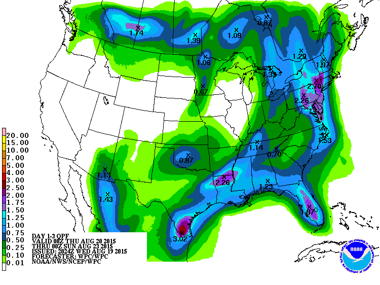
The last several computer model runs have been rather friendly with widespread rain (1-2 inches locally much higher) on Thursday for the Rio Grande Valley. Tomorrow will be interesting to see if the welcome rains verifies or not. :D

On a side note McAllen Airport had a low of 84 this morning and currently sitting at 102 with a heat index of 114!!! I'm so ready for Fall/Winter lol
0 likes   
The following post is NOT an official forecast and should not be used as such. It is just the opinion of the poster and may or may not be backed by sound meteorological data. It is NOT endorsed by any professional institution including storm2k.org For Official Information please refer to the NHC and NWS products.

weatherdude1108
Category 5
Category 5
Posts: 4174
Joined: Tue Dec 13, 2011 1:04 pm
Location: Northwest Austin/Cedar Park, TX

Re: Texas Summer-2015

#474 Postby weatherdude1108 » Wed Aug 19, 2015 2:31 pm

Portastorm wrote:This is for you, weatherdude. :wink:

Imagevia Imgflip Meme Maker


:A:
Haha! Yep.
0 likes   

Brent
S2K Supporter
S2K Supporter
Posts: 37143
Age: 35
Joined: Sun May 16, 2004 10:30 pm
Location: Tulsa Oklahoma
Contact:

Re: Texas Summer-2015

#475 Postby Brent » Wed Aug 19, 2015 3:30 pm

weatherdude1108 wrote:
Portastorm wrote:This is for you, weatherdude. :wink:

Imagevia Imgflip Meme Maker


:A:
Haha! Yep.


Story of winter and hurricane season too. :P
0 likes   
#neversummer

weatherdude1108
Category 5
Category 5
Posts: 4174
Joined: Tue Dec 13, 2011 1:04 pm
Location: Northwest Austin/Cedar Park, TX

#476 Postby weatherdude1108 » Wed Aug 19, 2015 3:32 pm

Speaking of models, a lot of talk on the models with our forecasting office. What happened to go ole' instinct forecasting, like Bill does in TWISTER?
:P
Image

000
FXUS64 KEWX 191950
AFDEWX

AREA FORECAST DISCUSSION
NATIONAL WEATHER SERVICE AUSTIN/SAN ANTONIO TX
250 PM CDT WED AUG 19 2015

.SHORT TERM (TODAY THROUGH THURSDAY)...
A COLD FRONT IS FORECAST TO PUSH ACROSS SOUTH CENTRAL TEXAS
TONIGHT AND STALLS NEAR HIGHWAY 90 OVERNIGHT. SCATTERED SHOWERS
AND THUNDERSTORMS ARE EXPECTED AHEAD AND ALONG THE
BOUNDARY...ESPECIALLY ACROSS THE EASTERN COUNTIES WHERE THE BEST
MOISTURE RESIDES. BOTH HIRES AND MEDIUM RANGE MODELS ARE HAVING
DIFFICULTIES ON HANDLING THE BOUNDARY AS WELL AS QPF VALUES.
BASED
ON RADAR TRENDS ACROSS THE HGX CWA...CANT RULE OUT ISOLATED BUT
HEAVY DOWNPOURS ACROSS THE COASTAL PLAINS AREA AND WHEN THE COLD
FRONT ARRIVES TO THE HILL COUNTRY AREA. SOME OF THESE STORMS COULD
BE STRONG WITH HEAVY RAIN...CLOUD TO GROUND LIGHTNING STRIKES AND
STRONG WIND GUSTS UP TO 50 MPH.
THERE MAY BE A BREAK OVERNIGHT
BEFORE SHOWERS AND STORMS PICK AGAIN THURSDAY MORNING MAINLY ALONG
AND EAST OF I-35. A COOL AIRMASS WILL SPREAD ACROSS THE AREA
OVERNIGHT INTO THURSDAY
WITH EXPECTED MAX TEMPS TO REACH ONLY THE
UPPER 80S ACROSS THE HILL COUNTRY TO LOWER AND MID 90S ELSEWHERE.

&&

.LONG TERM (THURSDAY NIGHT THROUGH TUESDAY)...
A DRIER WEATHER PATTERN WILL SETUP LATE THURSDAY INTO FRIDAY. ISOLATED
TO SCATTERED SHOWERS AND THUNDERSTORMS ARE ANTICIPATED FOR AREAS
ALONG THE COASTAL PLAINS MAINLY INDUCED BY SEABREEZE CONVECTION.
THE HOT SUMMER TEMPERATURES RETURN OVER THE WEEKEND WITH HIGHS IN
THE MID TO UPPER 90S. THERE IS A SLIGHT CHANCE OF RAIN BOTH
SATURDAY AND SUNDAY AFTERNOONS ACROSS THE SOUTHEASTERN COUNTIES.
ANOTHER COLD FRONT IS FORECAST TO APPROACH THE HILL COUNTRY EARLY
NEXT WEEK...HOWEVER...MEDIUM RANGE MODELS ARE NOT IN GOOD
AGREEMENT THIS FAR OUT. THEREFORE...THE EXTENDED FORECAST PERIOD
IS RELATIVELY DRY BUT EXPECT THIS TO CHANGE AS GUIDANCE COME TO
A BETTER SOLUTION.


My hopes for this event are waning. :(
Last edited by weatherdude1108 on Wed Aug 19, 2015 10:51 pm, edited 2 times in total.
0 likes   
The preceding post is NOT an official forecast, and should not be used as such. It is only the opinion of the poster and may or may not be backed by sound meteorological data. It is NOT endorsed by any professional institution including storm2k.org. For Official Information please refer to the NHC and NWS products.

gpsnowman
S2K Supporter
S2K Supporter
Posts: 2733
Joined: Fri Jan 07, 2011 10:35 am
Location: Grand Prairie Tx

#477 Postby gpsnowman » Wed Aug 19, 2015 4:36 pm

Man that north wind feels nice for August. Man did we get robbed on the rain. I do not think I have ever seen an August day which consisted of a hot and humid morning followed by a strong north wind with sporadic raindrops with towering clouds producing very little in the form of storms, to a drier, much less humid afternoon with the same north wind. Strange to say the least. Tomorrow morning and tomorrow in general are going to feel fantastic. Just wish we could have had a downpour preceding the cooler air. Next time.
0 likes   

User avatar
Rgv20
S2K Supporter
S2K Supporter
Posts: 2456
Age: 37
Joined: Wed Jan 05, 2011 5:42 pm
Location: Edinburg/McAllen Tx

#478 Postby Rgv20 » Wed Aug 19, 2015 8:30 pm

Ohh Please Verify!!

Image
0 likes   
The following post is NOT an official forecast and should not be used as such. It is just the opinion of the poster and may or may not be backed by sound meteorological data. It is NOT endorsed by any professional institution including storm2k.org For Official Information please refer to the NHC and NWS products.

TarrantWx
Category 1
Category 1
Posts: 287
Age: 38
Joined: Thu Jan 30, 2014 10:38 am
Location: Keller, TX

#479 Postby TarrantWx » Wed Aug 19, 2015 10:26 pm

Storms are really blowing up across the metroplex. Caught me off guard while I was walking my dog and saw lightning! :D
0 likes   

Brent
S2K Supporter
S2K Supporter
Posts: 37143
Age: 35
Joined: Sun May 16, 2004 10:30 pm
Location: Tulsa Oklahoma
Contact:

Re: Texas Summer-2015

#480 Postby Brent » Thu Aug 20, 2015 12:36 am

65 glorious degrees here. :D
0 likes   
#neversummer


Return to “USA & Caribbean Weather”

Who is online

Users browsing this forum: No registered users and 57 guests