Texas Summer - 2014

U.S. & Caribbean Weather Discussions and Severe Weather Events

Moderator: S2k Moderators

Forum rules

The posts in this forum are NOT official forecast and should not be used as such. They are just the opinion of the poster and may or may not be backed by sound meteorological data. They are NOT endorsed by any professional institution or STORM2K.

Help Support Storm2K
Message
Author
WeatherGuesser
Category 5
Category 5
Posts: 2672
Joined: Tue Jun 29, 2010 6:46 am

Re: Re:

#461 Postby WeatherGuesser » Sat Jul 19, 2014 4:28 pm

dhweather wrote:I haven't really looked at all the pieces yet for winter, but my inclination is the WSI is going to drop exponentially.


Not really interested in a repeat of last winter.


Where is Diboll in relation to all this rain and could it have possibly had anything to do with the ceiling collapse at the jail there?
0 likes   

User avatar
Ntxw
Storm2k Moderator
Storm2k Moderator
Posts: 22784
Joined: Wed Oct 21, 2009 6:34 pm
Location: DFW, Texas

Re: Re:

#462 Postby Ntxw » Sat Jul 19, 2014 7:06 pm

dhweather wrote:
Ntxw wrote:Still hovering in mid 70s after the noon hour at DFW. This has got to be one of the coolest week ever for July and definitely mid to late July. If you were told a few months ago there would be a string of days below 80 for highs in July people would think you were nuts.


No doubt. I've worn jeans two straight days and have been comfortable outside - IN JULY. Unprecedented.


I haven't really looked at all the pieces yet for winter, but my inclination is the WSI is going to drop exponentially.


The freak cool snaps that began last spring (2013) has continued, nothing has deviated from the norm. Analogs suggests fall starts early this year, likely below normal.

78F is the high so far today at the airport. In the meantime it's going to warm back up and get hot again to near normal for July. But there is another major trough and cool air mass lurking in the long range. Possibly residual effects of lingering WPAC typhoon activity.

Image

Image
0 likes   
The above post and any post by Ntxw is NOT an official forecast and should not be used as such. It is just the opinion of the poster and may or may not be backed by sound meteorological data. It is NOT endorsed by any professional institution including Storm2k. For official information, please refer to NWS products.

  Help support Storm2K!
Help Support Storm2K

User avatar
TheProfessor
Professional-Met
Professional-Met
Posts: 3506
Age: 28
Joined: Tue Dec 03, 2013 10:56 am
Location: Wichita, Kansas

#463 Postby TheProfessor » Sat Jul 19, 2014 8:36 pm

:uarrow: speaking of fall starting early this year, in a post before I said to watch and see how big the ant hills get as we approach fall and yesterday I saw the first large anthill of the summer. It seemed to have been built pretty fast.
0 likes   
An alumnus of The Ohio State University.

Your local National Weather Service office is your best source for weather information.

gpsnowman
S2K Supporter
S2K Supporter
Posts: 3185
Joined: Fri Jan 07, 2011 10:35 am
Location: Grand Prairie Tx

#464 Postby gpsnowman » Sat Jul 19, 2014 10:01 pm

What an incredible, record breaking, refreshing period of mid summer weather we have been able enjoy the last few days here in North Texas. Taking a step outside feeling and breathing this cool air can not be beat for July. Too bad it has to end. The dreaded heat will make comeback it seems. But wait! Another front could be on the way. Yes. Please.
0 likes   

User avatar
Ntxw
Storm2k Moderator
Storm2k Moderator
Posts: 22784
Joined: Wed Oct 21, 2009 6:34 pm
Location: DFW, Texas

#465 Postby Ntxw » Sun Jul 20, 2014 12:43 am

Last July one of our seasoned posters (Texas Snowman) posted JB's tweet on the CFSv2's winter forecast. It was spot on the money, so what does it have this July?

Image

Looks like your classic El Nino/-NAO couplet
0 likes   
The above post and any post by Ntxw is NOT an official forecast and should not be used as such. It is just the opinion of the poster and may or may not be backed by sound meteorological data. It is NOT endorsed by any professional institution including Storm2k. For official information, please refer to NWS products.


  Help support Storm2K!

Help Support Storm2K


User avatar
gboudx
S2K Supporter
S2K Supporter
Posts: 4080
Joined: Thu Sep 04, 2003 1:39 pm
Location: Rockwall, Tx but from Harvey, La

Re:

#466 Postby gboudx » Sun Jul 20, 2014 10:43 am

TheProfessor wrote::uarrow: speaking of fall starting early this year, in a post before I said to watch and see how big the ant hills get as we approach fall and yesterday I saw the first large anthill of the summer. It seemed to have been built pretty fast.


Probably because of all the rain. I have a couple of them now too.
0 likes   

User avatar
TheProfessor
Professional-Met
Professional-Met
Posts: 3506
Age: 28
Joined: Tue Dec 03, 2013 10:56 am
Location: Wichita, Kansas

#467 Postby TheProfessor » Sun Jul 20, 2014 12:29 pm

:uarrow: maybe, but why would they build it after it rains? maybe there's going to be a lot more rain later on this year. I've never seen ants build such a large mound after 1 big heavy rain event, especially after it has occurred?

P.S we only got about 2-2.5 inches (still good) here so are rain event wasn't as much as cities 15+ miles north of me.
0 likes   
An alumnus of The Ohio State University.

Your local National Weather Service office is your best source for weather information.

User avatar
gboudx
S2K Supporter
S2K Supporter
Posts: 4080
Joined: Thu Sep 04, 2003 1:39 pm
Location: Rockwall, Tx but from Harvey, La

#468 Postby gboudx » Sun Jul 20, 2014 4:57 pm

You can find the answer to the question about ant mounds and rain with a Google search. Here's one I'll share:
Why do mounds pop up after a rain? The ants are actively working the mounds – cleaning out tunnels and perhaps even preparing for a nuptial flight of reproductive ants (see question6).


http://www.uaex.edu/publications/pdf/FSA-7052.pdf

I did yard work today and there are fire ants everywhere, including more mounds. But we're off topic with this discussion at this point. I have noticed the NWS forecasted high temps have been trending downward for this week. Still hot, but not triple digits like a couple days ago.
0 likes   

User avatar
Ntxw
Storm2k Moderator
Storm2k Moderator
Posts: 22784
Joined: Wed Oct 21, 2009 6:34 pm
Location: DFW, Texas

#469 Postby Ntxw » Sun Jul 20, 2014 5:55 pm

Nothing new of late to add. Back to July heat, then we begin August with a cold front and unusual cool air. Trough will be centered over the Lakes but according the ENS the anomaly departures will be greatest similar to the recent blast.
0 likes   
The above post and any post by Ntxw is NOT an official forecast and should not be used as such. It is just the opinion of the poster and may or may not be backed by sound meteorological data. It is NOT endorsed by any professional institution including Storm2k. For official information, please refer to NWS products.


  Help support Storm2K!

Help Support Storm2K


User avatar
Tireman4
S2K Supporter
S2K Supporter
Posts: 5853
Age: 59
Joined: Fri Jun 30, 2006 1:08 pm
Location: Humble, Texas
Contact:

Re:

#470 Postby Tireman4 » Sun Jul 20, 2014 6:40 pm

Ntxw wrote:Nothing new of late to add. Back to July heat, then we begin August with a cold front and unusual cool air. Trough will be centered over the Lakes but according the ENS the anomaly departures will be greatest similar to the recent blast.


Man, this is really looking weirdly like 2004. What I mean is ( I swear I alluded to this before..LOL) that we had an August cold front come all the way through to Houston. It broke records too. I remember my beautiful bride and I standing in front of Lake Houston and nary a sweat to be had in those pictures. Now, Larry Cosgrove says he doubts this next cold front will come through Houston, but who knows.


See August 13-16 of 2004. See how low the temperatures were.


August 13 64 - 2004
August 14 65 - 2004
August 15 61 - 2004
August 16 63 - 2004

http://www.srh.noaa.gov/hgx/?n=climate_iah_normals_aug

What does this mean? I have no idea. I am just a guy trying to make a living. It just feels eerie, that is all.
0 likes   

User avatar
Ntxw
Storm2k Moderator
Storm2k Moderator
Posts: 22784
Joined: Wed Oct 21, 2009 6:34 pm
Location: DFW, Texas

#471 Postby Ntxw » Sun Jul 20, 2014 6:43 pm

Dr Ventrice posted this on his twitter page of the ECMWF to end July and begin August.

Image

All this at the hottest climo 2-3 weeks of the year. Better take a closer look at Matmo (WPAC).
0 likes   
The above post and any post by Ntxw is NOT an official forecast and should not be used as such. It is just the opinion of the poster and may or may not be backed by sound meteorological data. It is NOT endorsed by any professional institution including Storm2k. For official information, please refer to NWS products.


  Help support Storm2K!

Help Support Storm2K


WeatherGuesser
Category 5
Category 5
Posts: 2672
Joined: Tue Jun 29, 2010 6:46 am

Re: Re:

#472 Postby WeatherGuesser » Sun Jul 20, 2014 7:53 pm

Tireman4 wrote:Man, this is really looking weirdly like 2004. What I mean is ( I swear I alluded to this before..LOL) that we had an August cold front come all the way through to Houston. It broke records too. I remember my beautiful bride and I standing in front of Lake Houston and nary a sweat to be had in those pictures. Now, Larry Cosgrove says he doubts this next cold front will come through Houston, but who knows.


See August 13-16 of 2004. See how low the temperatures were.


August 13 64 - 2004
August 14 65 - 2004
August 15 61 - 2004
August 16 63 - 2004

http://www.srh.noaa.gov/hgx/?n=climate_iah_normals_aug


Ha! I just asked about that in another thread.
0 likes   

User avatar
TeamPlayersBlue
Category 5
Category 5
Posts: 3445
Joined: Tue Feb 02, 2010 1:44 am
Location: Denver/Applewood, CO

#473 Postby TeamPlayersBlue » Mon Jul 21, 2014 9:59 am

The post from JB looks similar to last years prediction except cooler in Houston. I believe due to more moisture or 'rain.' Yes, last year his prediction was spot on.
0 likes   
Personal Forecast Disclaimer:
The posts in this forum are NOT official forecast and should not be used as such. They are just the opinion of the poster and may or may not be backed by sound meteorological data. They are NOT endorsed by any professional institution or storm2k.org. For official information, please refer to the NHC and NWS products.

User avatar
Portastorm
Storm2k Moderator
Storm2k Moderator
Posts: 9914
Age: 63
Joined: Fri Jul 11, 2003 9:16 am
Location: Round Rock, TX
Contact:

Re: Texas Summer - 2014

#474 Postby Portastorm » Mon Jul 21, 2014 11:09 am

Meanwhile, back at the ranch, it looks like Heat Miser has full control of the Texas weather this week. Heat indices will be above 100 in too many places early this week and high temps will be sizzling. That's ok ... it's summer and it's Texas ... we have to have at least a little classic summer weather, right?! Besides if wxman57 doesn't get his way now ... he might be tough to deal with later in the year when most of us want to see much colder and wetter conditions. :wink:
0 likes   
Any forecasts under my name are to be taken with a grain of salt. Get your best forecasts from the National Weather Service and National Hurricane Center.

User avatar
Tireman4
S2K Supporter
S2K Supporter
Posts: 5853
Age: 59
Joined: Fri Jun 30, 2006 1:08 pm
Location: Humble, Texas
Contact:

Re: Texas Summer - 2014

#475 Postby Tireman4 » Mon Jul 21, 2014 11:13 am

Portastorm wrote:Meanwhile, back at the ranch, it looks like Heat Miser has full control of the Texas weather this week. Heat indices will be above 100 in too many places early this week and high temps will be sizzling. That's ok ... it's summer and it's Texas ... we have to have at least a little classic summer weather, right?! Besides if wxman57 doesn't get his way now ... he might be tough to deal with later in the year when most of us want to see much colder and wetter conditions. :wink:


Yep, all his moaning and groaning. Uggh. Goodness gracious.
0 likes   

User avatar
gboudx
S2K Supporter
S2K Supporter
Posts: 4080
Joined: Thu Sep 04, 2003 1:39 pm
Location: Rockwall, Tx but from Harvey, La

#476 Postby gboudx » Mon Jul 21, 2014 1:19 pm

It would be awesome if Heat Miser is on a work-related trip to somewhere cold this week. And by "cold" I mean 60's for highs.
0 likes   

weatherdude1108
Category 5
Category 5
Posts: 4228
Joined: Tue Dec 13, 2011 1:04 pm
Location: Northwest Austin/Cedar Park, TX

#477 Postby weatherdude1108 » Mon Jul 21, 2014 3:55 pm

I cherished that 69-degree morning on Saturday while it lasted. Last Friday and Saturday reminded me of Autumn. Re-energized me. :D Should have known it would not last. Heat Miser's influence was bound to overtake our joy at some point in July. :grrr: Now we bask in the sauna of the saturated soils being baked, with no trigger to stir up the buoyancy. :roll:

Ah well. Like I said, it should be hot and dry this time of year in Texas. But, a possible caveat to break this spell would be some potential tropical action brewing in the Atlantic, moving towards the Gulf, perhaps? :wink:

Texas Storm Chasers posted this:
http://www.texasstormchasers.com/2014/0 ... -atlantic/

Meanwhile:
EWX Discussion
FXUS64 KEWX 212028
AFDEWX

AREA FORECAST DISCUSSION
NATIONAL WEATHER SERVICE AUSTIN/SAN ANTONIO TX
328 PM CDT MON JUL 21 2014

.SHORT TERM (TONIGHT THROUGH TUESDAY NIGHT)...
PERSISTENT UPPER RIDGING OVER THE EASTERN ROCKIES AND HIGH PLAINS WILL CONTINUE THE SLOW WARMING TREND AS GROUND MOISTURE IS BAKED OUT OF AREA SOILS. AREAS ALONG AND EAST OF I-35 WILL SEE ENHANCED HEAT INDICES OF 102-107 DEGREES THIS AFTERNOON AND TUESDAY DUE TO THE HIGHER AMOUNTS OF RECENT RAINS COMBINED WITH DEEPER SOIL DEPTH BEFORE REACHING BEDROCK. TEMPERATURES AT NIGHT ARE EXPECTED TO
FALL INTO THE LOW TO MID 70S DUE TO LIGHT OVERNIGHT WINDS...SO THE THREAT OF REACHING HEAT ADVISORY CRITERIA IS LOW.

.LONG TERM (WEDNESDAY THROUGH MONDAY)...
HEAT INDICES MAY REACH AROUND 105 FOR ANOTHER DAY WEDNESDAY...AS MODELS SHOW A SLIGHT INCREASE IN PWAT VALUES SPREADING WEST FROM EAST TX. SOME OF THIS INCREASED MOISTURE COULD BE ACCOMPANIED BY INCREASED MID AND HIGH LEVEL CLOUDS WITH THE NAM MOST AGGRESSIVE AMONG SYNOPTIC MODELS TO GENERATE A CHANCE OF RAIN. BELIEVE THE 12Z NAM WAS TOO AGGRESSIVE ON MOISTURE ANALYSIS OVER SOUTH TX TODAY AND AM SKEPTICAL THAT MOISTURE WILL COME IN AS AGGRESSIVE AS ADVERTISED FOR WEDNESDAY. DPROG-DT OF THE GFS AND ECMWF SHOW AN INCREASE IN AN E-W EXTENSION OF THE UPPER RIDGE AXIS...WHICH SHOULD MAKE IT LESS LIKELY FOR PERTURBATIONS FROM DRIFTING SW FROM NE TX AS WAS DEPICTED BY THE 12Z NAM AND EARLIER RUNS OF THE GFS/ECMWF.
THE EXTENSION OF THE E-W UPPER RIDGE AXIS ALONG THE RED RIVER
CONTINUES IN RECENT MODEL TRENDS THROUGH THE WEEKEND...AND THE SHIFT TOWARD A MORE UNSTABLE MERIDIONAL PATTERN ALOFT OVER CENTRAL TEXAS EARLY NEXT WEEK COULD BE IN JEOPARDY. IF THE RIDGING TREND CONTINUES...MULTIPLE DAYS OF 100 DEGREE PLUS HEAT MAY BE IN THE WORKS FOR THE I-35 CORRIDOR AND POINTS WEST.
0 likes   
The preceding post is NOT an official forecast, and should not be used as such. It is only the opinion of the poster and may or may not be backed by sound meteorological data. It is NOT endorsed by any professional institution including storm2k.org. For Official Information please refer to the NHC and NWS products.

BrokenGlassRepublicn
Category 1
Category 1
Posts: 481
Joined: Sun Nov 20, 2011 8:07 pm
Location: Richardson, Texas

Re: Texas Summer - 2014

#478 Postby BrokenGlassRepublicn » Mon Jul 21, 2014 4:03 pm

Portastorm wrote:Meanwhile, back at the ranch, it looks like Heat Miser has full control of the Texas weather this week. Heat indices will be above 100 in too many places early this week and high temps will be sizzling. That's ok ... it's summer and it's Texas ... we have to have at least a little classic summer weather, right?! Besides if wxman57 doesn't get his way now ... he might be tough to deal with later in the year when most of us want to see much colder and wetter conditions. :wink:

I can't believe I'm about to say this, but I say bring it on for a few weeks. Because of the harsh winter and cool spring, the St. Augustine in North Texas was very slow to enter the growing season. I have a back yard that I'm desparatly trying to fill in with thicker grass before the fall, lest my dogs track in mud all winter.
0 likes   

TexasBreeze
Tropical Depression
Tropical Depression
Posts: 81
Joined: Mon Jul 07, 2014 12:50 pm

#479 Postby TexasBreeze » Mon Jul 21, 2014 4:51 pm

Hopefully maps showing below average temps around Texas come to fruition! It is nice to think about now while sitting here with a heat index of 109 by Tomball/Hooks airport.
0 likes   

aggiecutter
Category 5
Category 5
Posts: 1753
Joined: Thu Oct 14, 2004 9:22 pm
Location: Texarkana

Re: Texas Summer - 2014

#480 Postby aggiecutter » Tue Jul 22, 2014 7:17 pm

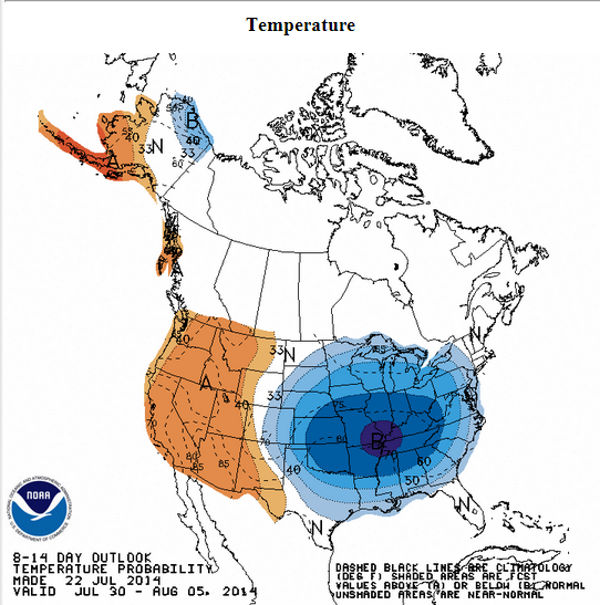
The cool weather returns next week:

Image
0 likes   


Return to “USA & Caribbean Weather”

Who is online

Users browsing this forum: No registered users and 8 guests