Texas Summer - 2013

U.S. & Caribbean Weather Discussions and Severe Weather Events

Moderator: S2k Moderators

Forum rules

The posts in this forum are NOT official forecast and should not be used as such. They are just the opinion of the poster and may or may not be backed by sound meteorological data. They are NOT endorsed by any professional institution or STORM2K.

Help Support Storm2K
Message
Author
User avatar
vbhoutex
Storm2k Executive
Storm2k Executive
Posts: 29112
Age: 73
Joined: Wed Oct 09, 2002 11:31 pm
Location: Cypress, TX
Contact:

Re:

#421 Postby vbhoutex » Fri Aug 23, 2013 2:34 pm

Ntxw wrote:Little update from guidance. Big dome of high pressure is going to anchor itself in the central plains roughly around Missouri. Texas is on the southern periphery. SE Texas and South Texas are going to see daily pop up scattered showers not unlike what's been going on for a few days. The feature in the eastern gulf is heading west and will roundabout underneath the flow of the high. Once this thing gets to TX we'll see more numerous showers especially the southern half of the state. The hottest temps will remain in the north 93-98 and mid 80s to lower 90s in the south in the more humid air to end the month.


LOL!! Sure it will!! I want some of what you are having!!! :P :roll: :lol:
I know what you stated above as far as the pattern is true, but I WILL BELIEVE IT WHEN IT HAPPENS!! I HOPE IT HAPPENS!! Those temps are fantasy for us in SE TX right now. 95f and rising. Not enough on radar right now to give me hope. We did have enough cloudiness yesterday that we only made it to 94f.
0 likes   
Skywarn, C.E.R.T.
Please click below to donate to STORM2K to help with the expenses of keeping the site going:
Image

gpsnowman
S2K Supporter
S2K Supporter
Posts: 3185
Joined: Fri Jan 07, 2011 10:35 am
Location: Grand Prairie Tx

#422 Postby gpsnowman » Fri Aug 23, 2013 9:17 pm

Man this a boring pattern we are in. Heat and humidity as far the forecast eye will see. Is it too early for the first cold front predictions? Come on people smarter than me, we need some bold guesses! I will just sit here and wait. :D
0 likes   

weatherdude1108
Category 5
Category 5
Posts: 4228
Joined: Tue Dec 13, 2011 1:04 pm
Location: Northwest Austin/Cedar Park, TX

#423 Postby weatherdude1108 » Fri Aug 23, 2013 10:08 pm

Something more interesting I came across today. Possible development of this little disturbance in the Gulf :eek: , according to Bob Rose. BRING IT. :rain: :rain: :rain:

http://www.lcra.org/water/conditions/we ... olumn.html
0 likes   
The preceding post is NOT an official forecast, and should not be used as such. It is only the opinion of the poster and may or may not be backed by sound meteorological data. It is NOT endorsed by any professional institution including storm2k.org. For Official Information please refer to the NHC and NWS products.

User avatar
horselattitudesfarm
Category 1
Category 1
Posts: 315
Joined: Thu Jul 16, 2009 5:55 pm
Location: Asheville, NC (formerly from Dallas, TX)

Re:

#424 Postby horselattitudesfarm » Sat Aug 24, 2013 9:53 am

gpsnowman wrote:Man this a boring pattern we are in. Heat and humidity as far the forecast eye will see. Is it too early for the first cold front predictions? Come on people smarter than me, we need some bold guesses! I will just sit here and wait. :D

You and I are living in the wrong place for the kind of weather we like. Before '05 we used to get quite a lot of dynamic weather, but I saw more exiting weather driving through the Mojave desert in Arizona 2 weeks ago than what we are getting here lately. Its pretty bad when Scottdale is getting more rain than we are :eek:
I should put this in a travel brochure: "Where else can you get the heat of the desert, the dry brown look of Southern California, AND the soupy humidity of the tropics all in one package......Dallas, of course! Yes folks, come get all your favorite weather conditions all in one place"
........Uh.....I guess I haven't gotten to the acceptance phase of this drought yet, but humor is helping :wink: By the way here is a little cartoon that fits me well:

Image
I guess I'm at the depression stage. Anyway here is the NWS forecast for our lovely weather:

ALTHOUGH A FEW AREAS MAY SEE BENEFICIAL RAINFALL OVER THE NEXT
COUPLE OF DAYS...MOST AREAS WILL NOT SEE ANY MEASURABLE RAINFALL
THROUGH THE COMING WEEK. UNFORTUNATELY...THERE ARE NO STRONG
INDICATIONS THAT THE UPPER RIDGE WILL BREAK DOWN OR MOVE AS WE
HEAD INTO EARLY SEPTEMBER. THE ONLY GLIMMER OF HOPE FOR INCREASING
RAIN CHANCES CAN BE SEEN IN THE 00Z ECMWF SOLUTION WHICH DOES
SHIFT THE UPPER RIDGE AXIS EAST OF THE MISSISSIPPI BY LABOR DAY.
0 likes   

User avatar
Portastorm
Storm2k Moderator
Storm2k Moderator
Posts: 9914
Age: 63
Joined: Fri Jul 11, 2003 9:16 am
Location: Round Rock, TX
Contact:

Re: Texas Summer - 2013

#425 Postby Portastorm » Sat Aug 24, 2013 10:09 am

I am moderately encouraged by what I'm seeing in the Gulf this morning, especially when looking at the water vapor satellite loops. Lots of moisture out there and it is moving our way. Hopefully it'll provide enough fuel for at least a decent coverage statewide of diurnal showers/storms tomorrow and Monday. That's probably the best we can hope for at this point. I certainly think we're at least 3-4 weeks away from the first cold front of the "fall" season.
0 likes   
Any forecasts under my name are to be taken with a grain of salt. Get your best forecasts from the National Weather Service and National Hurricane Center.

weatherdude1108
Category 5
Category 5
Posts: 4228
Joined: Tue Dec 13, 2011 1:04 pm
Location: Northwest Austin/Cedar Park, TX

Re: Re:

#426 Postby weatherdude1108 » Sat Aug 24, 2013 4:20 pm

horselattitudesfarm wrote:
gpsnowman wrote:Man this a boring pattern we are in. Heat and humidity as far the forecast eye will see. Is it too early for the first cold front predictions? Come on people smarter than me, we need some bold guesses! I will just sit here and wait. :D

You and I are living in the wrong place for the kind of weather we like. Before '05 we used to get quite a lot of dynamic weather, but I saw more exiting weather driving through the Mojave desert in Arizona 2 weeks ago than what we are getting here lately. Its pretty bad when Scottdale is getting more rain than we are :eek:
I should put this in a travel brochure: "Where else can you get the heat of the desert, the dry brown look of Southern California, AND the soupy humidity of the tropics all in one package......Dallas, of course! Yes folks, come get all your favorite weather conditions all in one place"
........Uh.....I guess I haven't gotten to the acceptance phase of this drought yet, but humor is helping :wink: By the way here is a little cartoon that fits me well:

Image
I guess I'm at the depression stage. Anyway here is the NWS forecast for our lovely weather:

ALTHOUGH A FEW AREAS MAY SEE BENEFICIAL RAINFALL OVER THE NEXT
COUPLE OF DAYS...MOST AREAS WILL NOT SEE ANY MEASURABLE RAINFALL
THROUGH THE COMING WEEK. UNFORTUNATELY...THERE ARE NO STRONG
INDICATIONS THAT THE UPPER RIDGE WILL BREAK DOWN OR MOVE AS WE
HEAD INTO EARLY SEPTEMBER. THE ONLY GLIMMER OF HOPE FOR INCREASING
RAIN CHANCES CAN BE SEEN IN THE 00Z ECMWF SOLUTION WHICH DOES
SHIFT THE UPPER RIDGE AXIS EAST OF THE MISSISSIPPI BY LABOR DAY.


Haha!! :lol: I laugh at the truth of this cartoon. I think I'm at the acceptance stage, feeling guilty for having any green in my lawn, with thoughts of how I am helping to accelerate the draining of Lake Travis to its all-time record low with every drop that hits the blades of water hogging St. Augustine. But, I am still obeying the once a week rules we have in place. Give it a deeper soaking to get it through the week of 100s.

Still, they need to up our water rates BECAUSE of the restrictions. Still costs the city money for the pumping and water treatment. Less used, less revenue, so they make up for it through raising the customer rates. Cruel irony! :x :roll:
0 likes   

weatherdude1108
Category 5
Category 5
Posts: 4228
Joined: Tue Dec 13, 2011 1:04 pm
Location: Northwest Austin/Cedar Park, TX

Re: Texas Summer - 2013

#427 Postby weatherdude1108 » Sat Aug 24, 2013 4:30 pm

Portastorm wrote:I am moderately encouraged by what I'm seeing in the Gulf this morning, especially when looking at the water vapor satellite loops. Lots of moisture out there and it is moving our way. Hopefully it'll provide enough fuel for at least a decent coverage statewide of diurnal showers/storms tomorrow and Monday. That's probably the best we can hope for at this point. I certainly think we're at least 3-4 weeks away from the first cold front of the "fall" season.


Raining here at the Weatherdude Center!! :rain: 97 degree steam bath! :rain:
0 likes   

User avatar
Ntxw
Storm2k Moderator
Storm2k Moderator
Posts: 22784
Joined: Wed Oct 21, 2009 6:34 pm
Location: DFW, Texas

#428 Postby Ntxw » Sun Aug 25, 2013 5:06 pm

Well it looks like I'm going to be wrong about summer ending early. I was hoping a decent named tropical system would effect us by now and yet to have done so. The ridge of high pressure over the central plains is impressive (arguably stronger than the one that effected us early in August). Good thing is it is not anchored over us but it does look like 100s are returning to the northern half of the state.
0 likes   
The above post and any post by Ntxw is NOT an official forecast and should not be used as such. It is just the opinion of the poster and may or may not be backed by sound meteorological data. It is NOT endorsed by any professional institution including Storm2k. For official information, please refer to NWS products.

  Help support Storm2K!
Help Support Storm2K

User avatar
Portastorm
Storm2k Moderator
Storm2k Moderator
Posts: 9914
Age: 63
Joined: Fri Jul 11, 2003 9:16 am
Location: Round Rock, TX
Contact:

Re:

#429 Postby Portastorm » Sun Aug 25, 2013 5:11 pm

Ntxw wrote:Well it looks like I'm going to be wrong about summer ending early. I was hoping a decent named tropical system would effect us by now and yet to have done so. The ridge of high pressure over the central plains is impressive (arguably stronger than the one that effected us early in August). Good thing is it is not anchored over us but it does look like 100s are returning to the northern half of the state.


Yep. That same high pressure ridge you're speaking of will be what limits our rain chances in south central Texas despite a healthy amount of tropical moisture moving into the state from the Gulf. Austin will see two days (Mon-Tue) of decent rain chances and then that's it. The high pressure ridge will exert its control into the Labor Day weekend.
0 likes   
Any forecasts under my name are to be taken with a grain of salt. Get your best forecasts from the National Weather Service and National Hurricane Center.

User avatar
Tireman4
S2K Supporter
S2K Supporter
Posts: 5853
Age: 59
Joined: Fri Jun 30, 2006 1:08 pm
Location: Humble, Texas
Contact:

Re:

#430 Postby Tireman4 » Sun Aug 25, 2013 5:49 pm

Ntxw wrote:Well it looks like I'm going to be wrong about summer ending early. I was hoping a decent named tropical system would effect us by now and yet to have done so. The ridge of high pressure over the central plains is impressive (arguably stronger than the one that effected us early in August). Good thing is it is not anchored over us but it does look like 100s are returning to the northern half of the state.


It will cool off...late September, but it will cool off. LOL
0 likes   

weatherdude1108
Category 5
Category 5
Posts: 4228
Joined: Tue Dec 13, 2011 1:04 pm
Location: Northwest Austin/Cedar Park, TX

#431 Postby weatherdude1108 » Sun Aug 25, 2013 7:36 pm

I saw the Farmer's Almanac prediction. Looks great for Texas! I'm betting on another false promise as this multi-year drought negative PDO continues. But, I'm always hoping for a miracle. :wink:

http://www.texasstormchasers.com/2013/0 ... -forecast/
0 likes   
The preceding post is NOT an official forecast, and should not be used as such. It is only the opinion of the poster and may or may not be backed by sound meteorological data. It is NOT endorsed by any professional institution including storm2k.org. For Official Information please refer to the NHC and NWS products.

User avatar
horselattitudesfarm
Category 1
Category 1
Posts: 315
Joined: Thu Jul 16, 2009 5:55 pm
Location: Asheville, NC (formerly from Dallas, TX)

Re:

#432 Postby horselattitudesfarm » Mon Aug 26, 2013 10:18 am

weatherdude1108 wrote:I saw the Farmer's Almanac prediction. Looks great for Texas! I'm betting on another false promise as this multi-year drought negative PDO continues. But, I'm always hoping for a miracle. :wink:

http://www.texasstormchasers.com/2013/0 ... -forecast/

I can't believe they can still publish that kind of garbage! :grr: I guess it still waxes nostalgic for us hopeful ones, and it is kind of a humorous read. I think your third sentence uncovers the hard scientific truth: negative PDO. This, combined with the global warming signature of 2 degrees F since the 1970's pretty much sums up our predicament in this state. (As quoted from John Neilson Gammon from the KXAN article about Texas drought referred to on a previous post:

"The state temperature has increased on average by about 2 degrees Fahrenheit since the 1970s, and so that impacts drought through evaporation and loss of water once it reaches the ground," he said. "While there is greater hurricane activity over the water that tends to suppress ordinary summer thunderstorm activity over land.")
0 likes   

User avatar
Rgv20
S2K Supporter
S2K Supporter
Posts: 2466
Age: 38
Joined: Wed Jan 05, 2011 5:42 pm
Location: Edinburg/McAllen Tx

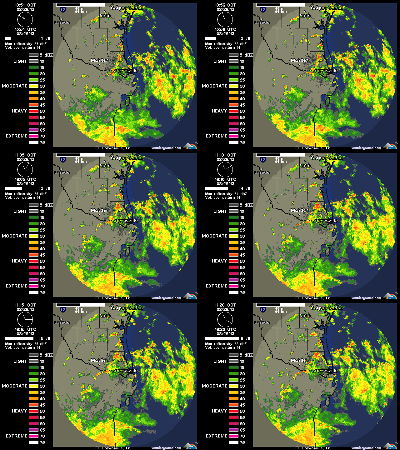
#433 Postby Rgv20 » Mon Aug 26, 2013 11:27 am

Radar sure looks busy! :D

Image
0 likes   
The following post is NOT an official forecast and should not be used as such. It is just the opinion of the poster and may or may not be backed by sound meteorological data. It is NOT endorsed by any professional institution including storm2k.org For Official Information please refer to the NHC and NWS products.

User avatar
Ntxw
Storm2k Moderator
Storm2k Moderator
Posts: 22784
Joined: Wed Oct 21, 2009 6:34 pm
Location: DFW, Texas

#434 Postby Ntxw » Mon Aug 26, 2013 1:54 pm

Not a bad day to be in Houston either huh? Mid 70s at IAH and raining. Wxman57 must be freaking out at the chill!

Image
0 likes   
The above post and any post by Ntxw is NOT an official forecast and should not be used as such. It is just the opinion of the poster and may or may not be backed by sound meteorological data. It is NOT endorsed by any professional institution including Storm2k. For official information, please refer to NWS products.


  Help support Storm2K!

Help Support Storm2K


weatherdude1108
Category 5
Category 5
Posts: 4228
Joined: Tue Dec 13, 2011 1:04 pm
Location: Northwest Austin/Cedar Park, TX

#435 Postby weatherdude1108 » Mon Aug 26, 2013 3:05 pm

:uarrow:
I'm watching it inch its way SLOWLY towards Austin from the east. Maybe we can get peak heating in to fuel this stuff(?). Time and again, I see gust fronts form ahead of the convection on radar. It gets breezy and cools off as the gust front blows through. That, in turn, cuts off the heating, and we get no rain. Hoping history does not repeat itself! Today and tomorrow are our only shots for rain, for who knows how long(?).

A silver lining is I did see that tomorrow's forecast rain chances here went from 30% to 40%.
0 likes   
The preceding post is NOT an official forecast, and should not be used as such. It is only the opinion of the poster and may or may not be backed by sound meteorological data. It is NOT endorsed by any professional institution including storm2k.org. For Official Information please refer to the NHC and NWS products.

User avatar
Portastorm
Storm2k Moderator
Storm2k Moderator
Posts: 9914
Age: 63
Joined: Fri Jul 11, 2003 9:16 am
Location: Round Rock, TX
Contact:

Re:

#436 Postby Portastorm » Mon Aug 26, 2013 4:07 pm

weatherdude1108 wrote::uarrow:
I'm watching it inch its way SLOWLY towards Austin from the east. Maybe we can get peak heating in to fuel this stuff(?). Time and again, I see gust fronts form ahead of the convection on radar. It gets breezy and cools off as the gust front blows through. That, in turn, cuts off the heating, and we get no rain. Hoping history does not repeat itself! Today and tomorrow are our only shots for rain, for who knows how long(?).

A silver lining is I did see that tomorrow's forecast rain chances here went from 30% to 40%.


It's the Austin Screwjob once again, weatherdude1108. Any popup showers are dissipating quickly in our area. Today our friends in SE and South Texas, including San Antonio, are winning the liquid gold lottery. Maybe tomorrow for us. Like you said, that'll be our last chance for at least another week if not two weeks. :roll:
0 likes   
Any forecasts under my name are to be taken with a grain of salt. Get your best forecasts from the National Weather Service and National Hurricane Center.

weatherdude1108
Category 5
Category 5
Posts: 4228
Joined: Tue Dec 13, 2011 1:04 pm
Location: Northwest Austin/Cedar Park, TX

Re: Re:

#437 Postby weatherdude1108 » Mon Aug 26, 2013 4:19 pm

Portastorm wrote:
weatherdude1108 wrote::uarrow:
I'm watching it inch its way SLOWLY towards Austin from the east. Maybe we can get peak heating in to fuel this stuff(?). Time and again, I see gust fronts form ahead of the convection on radar. It gets breezy and cools off as the gust front blows through. That, in turn, cuts off the heating, and we get no rain. Hoping history does not repeat itself! Today and tomorrow are our only shots for rain, for who knows how long(?).

A silver lining is I did see that tomorrow's forecast rain chances here went from 30% to 40%.


It's the Austin Screwjob once again, weatherdude1108. Any popup showers are dissipating quickly in our area. Today our friends in SE and South Texas, including San Antonio, are winning the liquid gold lottery. Maybe tomorrow for us. Like you said, that'll be our last chance for at least another week if not two weeks. :roll:


I just looked at the water vapor loop. Looks like we are between the moisture to the south and the dry (orange color) air to the north where our Dallas friends are trapped at the moment. Looks like the moisture is creeping north, trying to push the dry air back. I don't understand the clockwise motion of the plume(?) near Houston. It looks like the entire mass is moving north, but it is circulating clockwise back towards the Gulf like the Death ridge is fighting with it. :grr:
0 likes   
The preceding post is NOT an official forecast, and should not be used as such. It is only the opinion of the poster and may or may not be backed by sound meteorological data. It is NOT endorsed by any professional institution including storm2k.org. For Official Information please refer to the NHC and NWS products.

User avatar
South Texas Storms
Professional-Met
Professional-Met
Posts: 4224
Joined: Thu Jun 24, 2010 12:28 am
Location: Houston, TX

Re: Re:

#438 Postby South Texas Storms » Mon Aug 26, 2013 4:28 pm

Portastorm wrote:
weatherdude1108 wrote::uarrow:
I'm watching it inch its way SLOWLY towards Austin from the east. Maybe we can get peak heating in to fuel this stuff(?). Time and again, I see gust fronts form ahead of the convection on radar. It gets breezy and cools off as the gust front blows through. That, in turn, cuts off the heating, and we get no rain. Hoping history does not repeat itself! Today and tomorrow are our only shots for rain, for who knows how long(?).

A silver lining is I did see that tomorrow's forecast rain chances here went from 30% to 40%.


It's the Austin Screwjob once again, weatherdude1108. Any popup showers are dissipating quickly in our area. Today our friends in SE and South Texas, including San Antonio, are winning the liquid gold lottery. Maybe tomorrow for us. Like you said, that'll be our last chance for at least another week if not two weeks. :roll:


Actually it looks like San Antonio is gonna get screwed today too, as current radar now shows the rain weakening as it enters Bexar country from the east. I'm gonna be really disappointed if we don't get a drop from this event as the majority of the models showed us getting at least .25-.50 inch today through tomorrow. :(
0 likes   

User avatar
Portastorm
Storm2k Moderator
Storm2k Moderator
Posts: 9914
Age: 63
Joined: Fri Jul 11, 2003 9:16 am
Location: Round Rock, TX
Contact:

Re: Texas Summer - 2013

#439 Postby Portastorm » Mon Aug 26, 2013 5:00 pm

It is raining at my office at the moment (5 pm). Kinda surprised based on my look-see at the radar about 30 minutes ago.

STS, no rain in SA? You're kidding me?! It looked like a sure thing for y'all.
0 likes   
Any forecasts under my name are to be taken with a grain of salt. Get your best forecasts from the National Weather Service and National Hurricane Center.

User avatar
South Texas Storms
Professional-Met
Professional-Met
Posts: 4224
Joined: Thu Jun 24, 2010 12:28 am
Location: Houston, TX

Re: Texas Summer - 2013

#440 Postby South Texas Storms » Mon Aug 26, 2013 5:31 pm

Portastorm wrote:It is raining at my office at the moment (5 pm). Kinda surprised based on my look-see at the radar about 30 minutes ago.

STS, no rain in SA? You're kidding me?! It looked like a sure thing for y'all.


Just mainly some drizzle and light rain so far today. I really hope we can get some more within the next 24 hours before our rain chances sadly go away for at least the next 5 days.
0 likes   


Return to “USA & Caribbean Weather”

Who is online

Users browsing this forum: No registered users and 6 guests