Texas Spring-2015
Moderator: S2k Moderators
Forum rules

The posts in this forum are NOT official forecast and should not be used as such. They are just the opinion of the poster and may or may not be backed by sound meteorological data. They are NOT endorsed by any professional institution or STORM2K.
-
somethingfunny

- ChatStaff

- Posts: 3926
- Age: 37
- Joined: Thu May 31, 2007 10:30 pm
- Location: McKinney, Texas
-
gboudx

- S2K Supporter

- Posts: 4090
- Joined: Thu Sep 04, 2003 1:39 pm
- Location: Rockwall, Tx but from Harvey, La
Re:
dhweather wrote:RAIN, I WANT MORE RAIN!!! The soil at the surface is saturated, thus rain runs off into the LAKES.
Promptly, it looks pretty dry for the next week. BOOOOOO!!!
Sure is nice seeing the graphical linear increase in levels for both Lavon and Ray Hubbard right now.


0 likes
-
weatherdude1108
- Category 5

- Posts: 4228
- Joined: Tue Dec 13, 2011 1:04 pm
- Location: Northwest Austin/Cedar Park, TX
I'm driving to Huntsville tomorrow morning. What are the chances of running into rain in that area tomorrow (Thursday)? I guess I'll take a raincoat just in case.

0 likes
The preceding post is NOT an official forecast, and should not be used as such. It is only the opinion of the poster and may or may not be backed by sound meteorological data. It is NOT endorsed by any professional institution including storm2k.org. For Official Information please refer to the NHC and NWS products.
-
South Texas Storms

- Professional-Met

- Posts: 4258
- Joined: Thu Jun 24, 2010 12:28 am
- Location: Houston, TX
Re:
weatherdude1108 wrote:I'm driving to Huntsville tomorrow morning. What are the chances of running into rain in that area tomorrow (Thursday)? I guess I'll take a raincoat just in case.
There is about a 50% chance of rain in Huntsville tomorrow. I would take a raincoat just in case.
0 likes
-
weatherdude1108
- Category 5
- Posts: 4228
- Joined: Tue Dec 13, 2011 1:04 pm
- Location: Northwest Austin/Cedar Park, TX
Re: Re:
South Texas Storms wrote:weatherdude1108 wrote:I'm driving to Huntsville tomorrow morning. What are the chances of running into rain in that area tomorrow (Thursday)? I guess I'll take a raincoat just in case.
There is about a 50% chance of rain in Huntsville tomorrow. I would take a raincoat just in case.
Ok. I figured. Thanks!
0 likes

Last week the Euro was spinning up a low in the Gulf. Sure enough, there is a low in the gulf, just not a tropical storm.
0 likes
The above post and any post by dhweather is NOT an official forecast and should not be used as such. It is just the opinion of the poster and may or may not be backed by sound meteorological data. It is NOT endorsed by any professional institution including storm2k.org. For official information, please refer to NWS products.
-
gboudx
- S2K Supporter
- Posts: 4090
- Joined: Thu Sep 04, 2003 1:39 pm
- Location: Rockwall, Tx but from Harvey, La
Update from jeff on the Gulf low.
Fairly impressive surface low wrapping up east of Brownsville currently with a large rain shield heading for the upper TX coast.
CRP and BRO radars show a well defined circulation moving NNE over the western Gulf of Mexico with widespread light to moderate rainfall encompassing nearly the entire western Gulf. This rain shield should begin to spread inland this afternoon and short range guidance is becoming increasingly aggressive with rainfall tonight into early Thursday as this feature moves inland over SE TX.
Will increase rainfall amounts into the 1-2 inch range east of I-45 and .5 to 1.0 inch west of I-45 with amounts closer to .25 of an inch from Matagorda Bay to College Station. There will be a fairly strong rainfall gradient across the region with the eastern counties seeing the most and the western counties seeing the least.
This additional rainfall could have impacts on the ongoing flood waves on many of the local rivers.
0 likes

+PDO Nino win


0 likes
The above post and any post by Ntxw is NOT an official forecast and should not be used as such. It is just the opinion of the poster and may or may not be backed by sound meteorological data. It is NOT endorsed by any professional institution including Storm2k. For official information, please refer to NWS products.
Help support Storm2K!
-
weatherdude1108
- Category 5
- Posts: 4228
- Joined: Tue Dec 13, 2011 1:04 pm
- Location: Northwest Austin/Cedar Park, TX
Re:
dhweather wrote:Last week the Euro was spinning up a low in the Gulf. Sure enough, there is a low in the gulf, just not a tropical storm.
Or a Cat. 5.
0 likes
-
Ralph's Weather
- S2K Supporter
- Posts: 3371
- Age: 38
- Joined: Fri Dec 13, 2013 11:55 am
- Location: Lindale, TX
- Contact:
Re:
dhweather wrote:Last week the Euro was spinning up a low in the Gulf. Sure enough, there is a low in the gulf, just not a tropical storm.
It is looking kinda like an early season weak tropical system. SE TX and SW LA should see breezy conditions tonight along with the heavy rain. There have been plenty of weak tropical storms that have had less impact than this one will have.
0 likes
Follow on Facebook at Ralph's Weather.
-
srainhoutx

- S2K Supporter
- Posts: 6919
- Age: 68
- Joined: Sun Jan 14, 2007 11:34 am
- Location: Haywood County, NC
- Contact:
Re: Texas Spring-2015
From Nesdis:
SATELLITE PRECIPITATION ESTIMATES..DATE/TIME 03/11/15 1935Z
SATELLITE ANALYSIS BRANCH/NESDIS---NPPU---TEL.301-683-1404
LATEST DATA USED: 1915Z HANNA
.
LOCATION...LOUISIANA...TEXAS...
.
ATTN WFOS...LIX...LCH...HGX...
ATTN RFCS...LMRFC...WGRFC...
.
EVENT...SATELLITE FEATURES FOR DEVELOPING LOW IN W GULF
.
SATELLITE ANALYSIS AND TRENDS...WATER VAPOR IMAGERY SHOWED LARGE SCALE
PATTERN TO HAVE AN ANOMALOUS MID LEVEL TROF FROM THE S CNTRL STATES
EXTENDING S TO THE SUBTROPICAL E PAC. SHORTWAVE IMPULSE WAS EJECTING
OUT OF THE BASE OF THE TROF IN RESPONSE TO A STRONGER UPSTREAM IMPULSE
AMPLIFYING AND CLOSING OFF OVER W CNTRL MX. THE EJECTING DOWNSTREAM
IMPULSE HAS BEEN SHOWING SIGNS OF CLOSING OFF IN THE MID LEVELS AS A
COMMA HEAD HAS BEGUN TO DEVELOP OVER THE PAST FEW HOURS IN RESPONSE TO
A MID LEVEL JET STREAK LIFTING N THROUGH THE W GULF. THIS WOULD IMPLY
CYCLOGENESIS SHOULD CONTINUE JUST E OF THE COMMA HEAD NEAR 26N/94W AS
SYSTEM CONTINUES TO DEVELOP N THROUGHOUT THE AFTERNOON AND INTO THE
EVENING. SURFACE/SHIP/BUOY OBSERVATIONS ALONG WITH MOST RECENT METOP
ASCAT PASS INDICATE THAT SYNOPTIC BOUNDARY WAS SITUATED FROM ROUGHLY THE
MOUTH OF THE MS RIVER EXTENDING SW TOWARDS W GULF SURFACE LOW. HEAVIEST
RAINFALL HAS BEEN CONFINED TO NEAR BETTER GOES SOUNDER INSTABILITY AXIS
ALONG FRONTAL BOUNDARY BUT LIGHT TO MODERATE RAINFALL HAS BEEN APPROACHING
COASTAL AREAS WITHIN AREA OF DEFORMATION AND ALONG THE LEADING EDGE OF
STRENGTHENING LOW LEVEL FRONTOGENESIS N/NW OF SYSTEM. PROXIMITY TO LOW
LEVEL BOUNDARY AND INSTABILITY AXIS SHOULD ALLOW FOR THE POTENTIAL FOR
LOCALIZED HEAVY RAINFALL THREAT TO BEGIN APPROACHING PORTIONS OF SE LA
OVER THE NEXT FEW HOURS. BEYOND THAT, AS MID LEVEL JET STREAK CONTINUES
TO LIFT N OVER THE W GULF THROUGHOUT THE AFTERNOON AND INTO THE EVENING
IT SHOULD BEGIN TO COUPLE WITH DOWNSTREAM JET STREAK NEAR CREST OF MID
LEVEL RIDGE AXIS. THE LOW LEVEL RESPONSE TO THIS AND DECREASING HALF WAVE
LENGTH BETWEEN SHORTWAVE TROF AND RIDGE SHOULD BE A STRENGTHENING SE LLJ
NEAR REGION OF ANOMALOUS MOISTURE OVER THE NW GULF ON LATEST BLENDED
PW ANALYSIS. THIS SHOULD ALLOW FOR AN ENHANCED AREA OF INTEGRATED
MOISTURE TRANSPORT AND LOW LEVEL FRONTOGENESIS OVER REMNANT SYNOPTIC
BOUNDARY TO DEVELOP N/NW TOWARDS COASTAL LOCATIONS OF SW LA/SE TX DURING
THE EVENING HOURS SPREADING LOCALIZED HEAVY RAIN THREAT INTO THIS REGION.
SEE JUST ISSUED QPFERD AND QPFPFD FOR ADDITIONAL INFORMATION.
0 likes
Carla/Alicia/Jerry(In The Eye)/Michelle/Charley/Ivan/Dennis/Katrina/Rita/Wilma/Ike/Harvey
Member: National Weather Association
Wx Infinity Forums
http://wxinfinity.com/index.php
Facebook.com/WeatherInfinity
Twitter @WeatherInfinity
Member: National Weather Association
Wx Infinity Forums
http://wxinfinity.com/index.php
Facebook.com/WeatherInfinity
Twitter @WeatherInfinity

-
wxman57

- Moderator-Pro Met

- Posts: 23175
- Age: 68
- Joined: Sat Jun 21, 2003 8:06 pm
- Location: Houston, TX (southwest)
Re: Texas Spring-2015
It's a fairly typical west Gulf frontal low. Nothing tropical about it. We've seen quite a few out there this season. Strongest one I've ever seen was March 12-13, 1993 - the "Storm of the Century".
http://www.erh.noaa.gov/ilm/archive/Superstorm93/
http://ww2010.atmos.uiuc.edu/%28Gh%29/arch/cases/930312/sat/vis.rxml
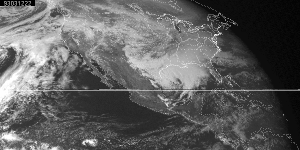
http://www.erh.noaa.gov/ilm/archive/Superstorm93/
http://ww2010.atmos.uiuc.edu/%28Gh%29/arch/cases/930312/sat/vis.rxml
0 likes
-
Ralph's Weather
- S2K Supporter
- Posts: 3371
- Age: 38
- Joined: Fri Dec 13, 2013 11:55 am
- Location: Lindale, TX
- Contact:
Today was forecasted to be partly cloudy, but the clouds have yet to break. After the early week storm I am up over 12" of liquid for the year with another couple inches possible tonight and tomorrow. The average to this date is around 8". Already around 5" in March so far.
0 likes
Follow on Facebook at Ralph's Weather.

Re: Texas Spring-2015
an outer band from that low has made it to Austin. Light rain falling here at my house. Won't be much but it's going to keep the soil nice and damp.
0 likes
Resident Rain Miser
I am a weather hobbyist living 3.5 miles south of Downtown Austin and in no way or fashion should anything I say concerning forecasts be taken seriously. Please check your local NWS for accurate weather forecasting and conditions.
I am a weather hobbyist living 3.5 miles south of Downtown Austin and in no way or fashion should anything I say concerning forecasts be taken seriously. Please check your local NWS for accurate weather forecasting and conditions.
-
Montgomery
- Tropical Wave

- Posts: 7
- Age: 53
- Joined: Tue Sep 30, 2014 7:56 am
- Location: Montgomery, TX (AKA 60 miles North of Houston)
Re: Texas Spring-2015
wxman57 wrote:It's a fairly typical west Gulf frontal low. Nothing tropical about it. We've seen quite a few out there this season. Strongest one I've ever seen was March 12-13, 1993 - the "Storm of the Century".
http://www.erh.noaa.gov/ilm/archive/Superstorm93/
http://ww2010.atmos.uiuc.edu/%28Gh%29/arch/cases/930312/sat/vis.rxml
http://ww2010.atmos.uiuc.edu/%28Gh%29/a ... 031222.gif
That was an impressive storm for sure.
0 likes
Anything I post shouldn't even been read, much less considered to be true!!
-
wxman57
- Moderator-Pro Met
- Posts: 23175
- Age: 68
- Joined: Sat Jun 21, 2003 8:06 pm
- Location: Houston, TX (southwest)
Re: Texas Spring-2015
The low center is right on the upper TX coast south of Port Arthur. Nothing tropical about it. Winds 20-25 kts offshore, typical of a weak west Gulf frontal low. Satellite indicates some sunshine mostly west of a line from Dallas to Austin. I wonder what the sun looks like...
0 likes
-
Portastorm

- Storm2k Moderator

- Posts: 9955
- Age: 63
- Joined: Fri Jul 11, 2003 9:16 am
- Location: Round Rock, TX
- Contact:
Re: Texas Spring-2015
wxman57 wrote:The low center is right on the upper TX coast south of Port Arthur. Nothing tropical about it. Winds 20-25 kts offshore, typical of a weak west Gulf frontal low. Satellite indicates some sunshine mostly west of a line from Dallas to Austin. I wonder what the sun looks like...
It looks great! Bright sunshine and a little breeze here in the capital of Texas. Beautiful weather. Come over, wxman57!
0 likes
Any forecasts under my name are to be taken with a grain of salt. Get your best forecasts from the National Weather Service and National Hurricane Center.
-
wxman57
- Moderator-Pro Met
- Posts: 23175
- Age: 68
- Joined: Sat Jun 21, 2003 8:06 pm
- Location: Houston, TX (southwest)
Re: Texas Spring-2015
Portastorm wrote:wxman57 wrote:The low center is right on the upper TX coast south of Port Arthur. Nothing tropical about it. Winds 20-25 kts offshore, typical of a weak west Gulf frontal low. Satellite indicates some sunshine mostly west of a line from Dallas to Austin. I wonder what the sun looks like...
It looks great! Bright sunshine and a little breeze here in the capital of Texas. Beautiful weather. Come over, wxman57!
I'll be there March 30th for the NHC.
0 likes
-
Lagreeneyes03
- Category 2

- Posts: 610
- Joined: Mon Dec 09, 2013 10:53 am
- Location: Luxurious Lake Grapevine
Return to “USA & Caribbean Weather”
Who is online
Users browsing this forum: Brent, Cpv17, opticsguy, txtwister78, wxman22 and 105 guests