Next round of severe weather 7th May Onwards?

U.S. & Caribbean Weather Discussions and Severe Weather Events

Moderator: S2k Moderators

Forum rules

The posts in this forum are NOT official forecast and should not be used as such. They are just the opinion of the poster and may or may not be backed by sound meteorological data. They are NOT endorsed by any professional institution or STORM2K.

Help Support Storm2K
Message
Author
User avatar
KWT
Category 5
Category 5
Posts: 31415
Joined: Tue Aug 17, 2004 11:02 am
Location: UK!!!

Re:

#381 Postby KWT » Mon May 10, 2010 5:48 pm

Texas Snowman wrote:MASSIVE TORNADO on the ground in or very near eastern Norman.

Trailer park reportedly demolished...


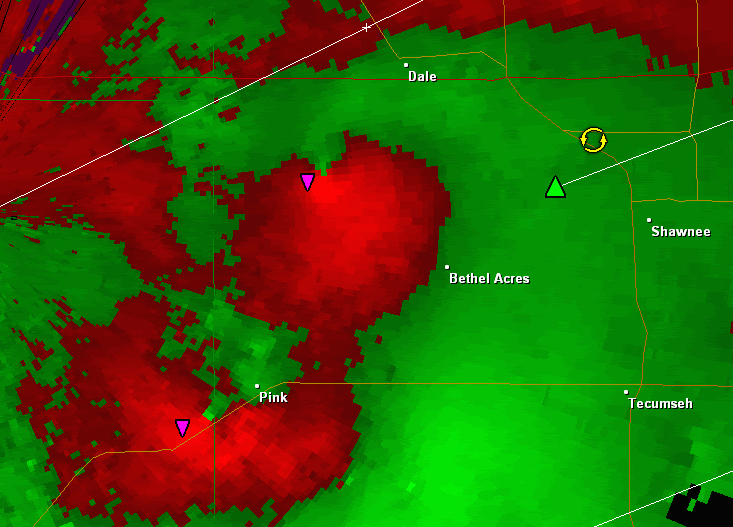
Yep, the storm just coming out of the radar clutter now so will be interesting to see just how good it looks on radar...
0 likes   
Personal Forecast Disclaimer:
The posts in this forum are NOT official forecast and should not be used as such. They are just the opinion of the poster and may or may not be backed by sound meteorological data. They are NOT endorsed by any professional institution or storm2k.org. For official information, please refer to the NHC and NWS products

CrazyC83
Professional-Met
Professional-Met
Posts: 34002
Joined: Tue Mar 07, 2006 11:57 pm
Location: Deep South, for the first time!

#382 Postby CrazyC83 » Mon May 10, 2010 5:48 pm

I'll probably need to have that article done by this evening. Once the tornadoes clear OKC, I'll start working on it.

SPC is still working BTW.
0 likes   

User avatar
Dave
Retired Staff
Retired Staff
Posts: 13442
Age: 74
Joined: Tue Aug 01, 2006 3:57 pm
Location: Milan Indiana
Contact:

#383 Postby Dave » Mon May 10, 2010 5:49 pm

Got 4 TVS's on the OKC cell
0 likes   

CrazyC83
Professional-Met
Professional-Met
Posts: 34002
Joined: Tue Mar 07, 2006 11:57 pm
Location: Deep South, for the first time!

#384 Postby CrazyC83 » Mon May 10, 2010 5:49 pm

Official or not, treat this as a Tornado Emergency for the SE metro.
0 likes   

User avatar
Dave
Retired Staff
Retired Staff
Posts: 13442
Age: 74
Joined: Tue Aug 01, 2006 3:57 pm
Location: Milan Indiana
Contact:

#385 Postby Dave » Mon May 10, 2010 5:53 pm

Image
0 likes   

CrazyC83
Professional-Met
Professional-Met
Posts: 34002
Joined: Tue Mar 07, 2006 11:57 pm
Location: Deep South, for the first time!

#386 Postby CrazyC83 » Mon May 10, 2010 5:53 pm

Radar indicated? Communications to Norman must be down since they are all ground-confirmed. Should be a Tornado Emergency here.

WWUS54 KOUN 102252 RRA
SVSOUN

SEVERE WEATHER STATEMENT
NATIONAL WEATHER SERVICE NORMAN OK
552 PM CDT MON MAY 10 2010

OKC027-081-109-125-102315-
/O.CON.KOUN.TO.W.0012.000000T0000Z-100510T2315Z/
LINCOLN OK-OKLAHOMA OK-POTTAWATOMIE OK-CLEVELAND OK-
552 PM CDT MON MAY 10 2010

...A TORNADO WARNING REMAINS IN EFFECT UNTIL 615 PM CDT FOR
NORTHEASTERN CLEVELAND...NORTHERN POTTAWATOMIE...SOUTHEASTERN
OKLAHOMA AND SOUTHWESTERN LINCOLN COUNTIES...

AT 550 PM CDT...NATIONAL WEATHER SERVICE RADAR DETECTED SEVERE
THUNDERSTORMS CAPABLE OF PRODUCING FOUR TORNADOES. ONE CIRCULATION
WAS LOCATED SOUTH OF HARRAH. ANOTHER CIRCULATION WAS SOUTHWEST OF
DALE. TWO OTHER CIRCULATIONS WERE LOCATED JUST EAST OF LAKE
THUNDERBIRD AND THEN ALONG HIGHWAY NINE JUST PAST THE COUNTYLINE
INTO POTTAWATOMIE COUNTY...MOVING EAST AT 45 TO 50 MPH.

* LOCATIONS IN THE WARNING INCLUDE EASTERN NORMAN...SHAWNEE AND
SOUTHEASTERN OKLAHOMA CITY.

THIS INCLUDES INTERSTATE 40 BETWEEN MILE MARKERS 160 AND 192.

PRECAUTIONARY/PREPAREDNESS ACTIONS...

IN ADDITION TO A TORNADO THREAT... THIS STORM LIKELY CONTAINS
DAMAGING HAIL TO THE SIZE OF BASEBALLS OR LARGER.

TAKE COVER NOW. LEAVE MOBILE HOMES AND VEHICLES. IF POSSIBLE...MOVE
TO A BASEMENT OR STORM SHELTER. OTHERWISE MOVE TO AN INTERIOR ROOM OR
HALLWAY ON THE LOWEST FLOOR. STAY AWAY FROM WINDOWS AND OUTSIDE
WALLS.

&&

LAT...LON 3515 9731 3542 9739 3567 9686 3517 9678
TIME...MOT...LOC 2250Z 253DEG 42KT 3525 9716

$$


MAXWELL
0 likes   

User avatar
Dave
Retired Staff
Retired Staff
Posts: 13442
Age: 74
Joined: Tue Aug 01, 2006 3:57 pm
Location: Milan Indiana
Contact:

#387 Postby Dave » Mon May 10, 2010 5:54 pm

Southern OK...new one...

BULLETIN - EAS ACTIVATION REQUESTED
TORNADO WARNING
NATIONAL WEATHER SERVICE NORMAN OK
549 PM CDT MON MAY 10 2010

THE NATIONAL WEATHER SERVICE IN NORMAN HAS ISSUED A

* TORNADO WARNING FOR...
WESTERN CARTER COUNTY IN SOUTHERN OKLAHOMA...
NORTHEASTERN JEFFERSON COUNTY IN SOUTHERN OKLAHOMA...
SOUTHEASTERN STEPHENS COUNTY IN SOUTHERN OKLAHOMA...

* UNTIL 615 PM CDT

* AT 549 PM CDT...RADAR AND STORM SPOTTERS OBSERVED A TORNADO 9 MILES
WEST OF CORNISH...MOVING EAST AT 45 MPH.

* LOCATIONS IN THE WARNING INCLUDE CORNISH...FOX...GRAHAM...
HEALDTON...MILO...RINGLING AND WILSON.

PRECAUTIONARY/PREPAREDNESS ACTIONS...

TAKE COVER NOW. LEAVE MOBILE HOMES AND VEHICLES. IF POSSIBLE...MOVE
TO A BASEMENT OR STORM SHELTER. OTHERWISE MOVE TO AN INTERIOR ROOM OR
HALLWAY ON THE LOWEST FLOOR. STAY AWAY FROM WINDOWS AND OUTSIDE
WALLS.
0 likes   

User avatar
brunota2003
S2K Supporter
S2K Supporter
Posts: 9476
Age: 34
Joined: Sat Jul 30, 2005 9:56 pm
Location: Stanton, KY...formerly Havelock, NC
Contact:

#388 Postby brunota2003 » Mon May 10, 2010 5:54 pm

One large, violent tornado and 3 satellite tornadoes perhaps?
0 likes   

User avatar
KWT
Category 5
Category 5
Posts: 31415
Joined: Tue Aug 17, 2004 11:02 am
Location: UK!!!

#389 Postby KWT » Mon May 10, 2010 5:55 pm

Yeah as you say Crazy totally confirmed on the ground, I was wondering why they have kept calling it radar indicated tornado...
0 likes   
Personal Forecast Disclaimer:
The posts in this forum are NOT official forecast and should not be used as such. They are just the opinion of the poster and may or may not be backed by sound meteorological data. They are NOT endorsed by any professional institution or storm2k.org. For official information, please refer to the NHC and NWS products

CrazyC83
Professional-Met
Professional-Met
Posts: 34002
Joined: Tue Mar 07, 2006 11:57 pm
Location: Deep South, for the first time!

#390 Postby CrazyC83 » Mon May 10, 2010 5:55 pm

Widespread damage across OKC Metro, some of it severe to catastrophic.

Probably multiple tornadoes, some EF3 to EF5.
0 likes   

User avatar
Dave
Retired Staff
Retired Staff
Posts: 13442
Age: 74
Joined: Tue Aug 01, 2006 3:57 pm
Location: Milan Indiana
Contact:

#391 Postby Dave » Mon May 10, 2010 5:55 pm

MAY 10 183200 EDT
TSTM WND GST
2 SE NORMAN
64 MPH
CLEVELAND CTY
OK
NWS EMPLOYEE
56 KT WIND GUST MEASURED BY
ANEMOMETER AT NW CENTER AS
FUNNEL PASSED NEARBY
0 likes   

User avatar
Texas Snowman
Storm2k Moderator
Storm2k Moderator
Posts: 6179
Joined: Fri Jan 25, 2008 11:29 am
Location: Denison, Texas

Re: Next round of severe weather 7th May Onwards?

#392 Postby Texas Snowman » Mon May 10, 2010 5:56 pm

Reports of lots of homes damaged near I-40, the Loyld Noble Center (OU Basketball) possibly damaged, Sonic restaraunt destroyed in Norman...

Mike Beatis of TWC reporting visual on large tornado west of Shawnee (?)
0 likes   
The above post and any post by Texas Snowman is NOT an official forecast and should not be used as such. It is just the opinion of the poster and may or may not be backed by sound meteorological data. It is NOT endorsed by any professional institution including storm2k.org. For official information, please refer to NWS products.

User avatar
Dave
Retired Staff
Retired Staff
Posts: 13442
Age: 74
Joined: Tue Aug 01, 2006 3:57 pm
Location: Milan Indiana
Contact:

#393 Postby Dave » Mon May 10, 2010 5:56 pm

LINCOLN OK-
552 PM CDT MON MAY 10 2010

...A TORNADO WARNING REMAINS IN EFFECT UNTIL 615 PM CDT FOR NORTHERN
LINCOLN COUNTY...

AT 552 PM CDT...NATIONAL WEATHER SERVICE RADAR DETECTED A SEVERE
THUNDERSTORM CAPABLE OF PRODUCING A TORNADO NEAR TRYON...MOVING
NORTHEAST AT 55 MPH.

* LOCATIONS IN THE WARNING INCLUDE AGRA...AVERY...CARNEY...
KENDRICK...PARKLAND AND TRYON.
0 likes   

User avatar
KatDaddy
Category 5
Category 5
Posts: 2815
Joined: Mon Oct 21, 2002 6:23 pm
Location: League City, Texas

#394 Postby KatDaddy » Mon May 10, 2010 5:56 pm

Where are you hearing that CrazyC83????
0 likes   
The following post is NOT an official forecast and should not be used as such. It is just the opinion of the poster and may or may not be backed by sound meteorological data. It is NOT endorsed by any professional institution including storm2k.org For Official Information please refer to the NHC and NWS products.

CrazyC83
Professional-Met
Professional-Met
Posts: 34002
Joined: Tue Mar 07, 2006 11:57 pm
Location: Deep South, for the first time!

Re:

#395 Postby CrazyC83 » Mon May 10, 2010 5:57 pm

KWT wrote:Yeah as you say Crazy totally confirmed on the ground, I was wondering why they have kept calling it radar indicated tornado...


They may not have communications to the building right now from spotters. Surprised they didn't call in Tulsa (or whoever their backup is).
0 likes   

CrazyC83
Professional-Met
Professional-Met
Posts: 34002
Joined: Tue Mar 07, 2006 11:57 pm
Location: Deep South, for the first time!

Re:

#396 Postby CrazyC83 » Mon May 10, 2010 5:57 pm

KatDaddy wrote:Where are you hearing that CrazyC83????


KWTV coverage had multiple areas of severe damage. The ratings are a guess - I doubt there was an EF5 but who knows.
0 likes   

User avatar
Bunkertor
Category 5
Category 5
Posts: 3397
Joined: Tue May 09, 2006 3:48 pm

#397 Postby Bunkertor » Mon May 10, 2010 5:57 pm

Fu*k
0 likes   

CrazyC83
Professional-Met
Professional-Met
Posts: 34002
Joined: Tue Mar 07, 2006 11:57 pm
Location: Deep South, for the first time!

#398 Postby CrazyC83 » Mon May 10, 2010 5:58 pm

Lone Grove, devastated last year, faces another tornado...now warned...
0 likes   

User avatar
Dave
Retired Staff
Retired Staff
Posts: 13442
Age: 74
Joined: Tue Aug 01, 2006 3:57 pm
Location: Milan Indiana
Contact:

#399 Postby Dave » Mon May 10, 2010 5:58 pm

Looking west from Shawnee OK

Image
0 likes   

snoopj
Category 2
Category 2
Posts: 530
Joined: Wed Sep 10, 2003 9:46 pm
Location: KCMO
Contact:

#400 Postby snoopj » Mon May 10, 2010 5:58 pm

KOCO is showing some damage from the their chopper from East Norman. Some pretty significant damage to buildings.
0 likes   


Return to “USA & Caribbean Weather”

Who is online

Users browsing this forum: snownado, TomballEd and 29 guests