Texas Summer 2016

U.S. & Caribbean Weather Discussions and Severe Weather Events

Moderator: S2k Moderators

Forum rules

The posts in this forum are NOT official forecast and should not be used as such. They are just the opinion of the poster and may or may not be backed by sound meteorological data. They are NOT endorsed by any professional institution or STORM2K.

Help Support Storm2K
Message
Author
weatherdude1108
Category 5
Category 5
Posts: 4228
Joined: Tue Dec 13, 2011 1:04 pm
Location: Northwest Austin/Cedar Park, TX

Re: Texas Summer 2016

#361 Postby weatherdude1108 » Fri Jul 29, 2016 2:56 pm

My model interpretation was affirmed by the EWX office in their last paragraph. :cheesy:

000
FXUS64 KEWX 291946 AAA
AFDEWX

Area Forecast Discussion...UPDATED
National Weather Service Austin/San Antonio TX
246 PM CDT FRI JUL 29 2016

.SHORT TERM (Tonight through Saturday)...

Main highlight will be the low-end rain chances today (20-30%)
that will drop further over the weekend while temperatures and
heat indices rise.

A combination of surface heating-driven instability and a weak
mid- to upper-level shear axis over central Texas is aiding in
isolated to scattered showers in the coastal plains and over the
Edwards Plateau. Earlier this morning a strong outflow boundary
from a previous storm complex in OK is now the focus of new
development in north-central Texas. It is unlikely that this
outflow will make it to south-central Texas. Just north across
Edwards Plateau however, exists scattered thunderstorms where the
shear axis and deeper mid to upper level moisture exist. Feel some
additional activity could develop across the Hill Country and the
southern Edwards Plateau through the afternoon. Coastal plains
storms will persist into the early evening hours and could produce
very localized 1-2 inch amounts. All activity will dissipate
through 8-9pm. Current heat indices are climbing into the 100-105
range as of 3pm and could top out in the 103-108 range through
6-7pm.

Clouds will return overnight with lows falling into the low to
mid 70s. Saturday will feature less shower coverage but still a
few isolated showers/storms could develop across the coastal
plains and again over the Edwards Plateau. A weak upper-level
vorticity max can be seen via water vapor satellite and this could
help increase coverage more than models suggest. Will need to
watch if 20-30% rain chances need to be expanded farther west
across Atascosa and into portions of the Rio Grande Plains. Heat
indices will once again rise into the 103-108 range for the
coastal plains on Saturday where rain showers do not occur.

&&

.LONG TERM (Sunday through Friday)...

Generally dry and above normal temperatures are expected through
much of next week with only small pockets of isolated showers and
storms.

The weak upper-level low will shift over the mid Rio Grande
Valley by Sunday but mid- to low-level ridging is expected to
strengthen at the same time. This additional suppression should
help quell shower activity more than today and Saturday.
Temperatures will also be ticking up with metro areas nearing the
100 mark again and Del Rio in the low 100s.

Through mid-week, the ridge strengthens further to 594 DM over
Texas and this should firmly place us with little rain and
continued hot temperatures each afternoon. A special weather
statement may be needed during this time for heat indices reaching
into the 105-109 range for a couple hours each afternoon.

By late week, another upper level-low will break off from the jet
stream and become centered over Texas the low to mid level ridging
breaks down. This should allow for slightly better shower coverage
across the coastal plains and inland.
One significance of this
ridge breakdown could come into play late next weekend as long
range models are suggesting the possibility of a tropical system
within the Gulf of Mexico. If the ridge breaks down, it could
allow for a tropical system of some type to shift farther north.
It is too far out to determine any details and whether this
solution will play out or not. Please stay through next week on
this possibility.
0 likes   
The preceding post is NOT an official forecast, and should not be used as such. It is only the opinion of the poster and may or may not be backed by sound meteorological data. It is NOT endorsed by any professional institution including storm2k.org. For Official Information please refer to the NHC and NWS products.

User avatar
TheProfessor
Professional-Met
Professional-Met
Posts: 3506
Age: 28
Joined: Tue Dec 03, 2013 10:56 am
Location: Wichita, Kansas

Re: Texas Summer 2016

#362 Postby TheProfessor » Fri Jul 29, 2016 3:16 pm

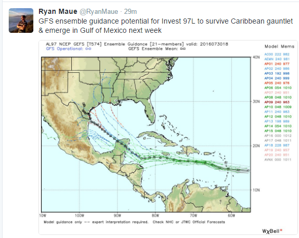
People on the Texas coast should keep an eye on 97L, Track and Speed will be important, but it looks like it could turn into a hurricane if it survives the Caribbean. We're still a week out though so a lot could change.
0 likes   
An alumnus of The Ohio State University.

Your local National Weather Service office is your best source for weather information.

User avatar
Ntxw
Storm2k Moderator
Storm2k Moderator
Posts: 22784
Joined: Wed Oct 21, 2009 6:34 pm
Location: DFW, Texas

Re: Texas Summer 2016

#363 Postby Ntxw » Sat Jul 30, 2016 10:57 am

This is it folks, this coming week through the 10th of August is the Climatological peak of summer for most in Texas (I-35 corridor and east). You will see averages decrease slowly starting with the overnight lows. This is summer's equivalent to February. The Arctic is getting darker, and colder.

If you are looking for rain in the coming months I would look towards the EPAC and for storms threatening the west coast of Mexico. Our second rainy season is always in tandem with this period (late Sept into October). Often not directly, but when fronts combine with their moisture, it works. As for the Atlantic, keep an eye but I've lost faith in this basin to bring us meaningful rain over the years. It's been east of us in subsidence or down into Mexico. Aside from tropical storm Bill last year, the only other named system to have brought meaningful rain for Texas was Hermine in 2010, 6 years ago and even she had origins from the Pacific side.
0 likes   
The above post and any post by Ntxw is NOT an official forecast and should not be used as such. It is just the opinion of the poster and may or may not be backed by sound meteorological data. It is NOT endorsed by any professional institution including Storm2k. For official information, please refer to NWS products.

  Help support Storm2K!
Help Support Storm2K

User avatar
Rgv20
S2K Supporter
S2K Supporter
Posts: 2466
Age: 38
Joined: Wed Jan 05, 2011 5:42 pm
Location: Edinburg/McAllen Tx

Re: Texas Summer 2016

#364 Postby Rgv20 » Sat Jul 30, 2016 3:02 pm

NWS Brwosville afternoon discussion regarding 97L.....Bears Watch!

A strong tropical wave located about 550 miles east of the Lesser
Antilles is moving rapidly west at 25 to 30 mph. By the middle of
the week, the disturbance should be in the western Caribbean,
where there may be a better chance of development. The GFS is the
more aggressive model in terms of developing something tropical in
the Bay of Campeche on Thursday and later, while the ECMWF and
Canadian are more conservative. In any case, deep South Texas
could potentially see some increase in tropical moisture by late
in the week. A model consensus begins to increase rain chances
around Thursday, slowly increasing the potential to around 40
percent through Friday and Saturday. This was not much different
from the inherited forecast and therefore felt comfortable
maintaining a persistent forecast pending later updates. Due to a
still meaningful geographic separation with the southwest Gulf,
most other longer term forecast fields were minimally impacted by
the somewhat more aggressive GFS solution.
0 likes   
The following post is NOT an official forecast and should not be used as such. It is just the opinion of the poster and may or may not be backed by sound meteorological data. It is NOT endorsed by any professional institution including storm2k.org For Official Information please refer to the NHC and NWS products.

aggiecutter
Category 5
Category 5
Posts: 1753
Joined: Thu Oct 14, 2004 9:22 pm
Location: Texarkana

Re: Texas Summer 2016

#365 Postby aggiecutter » Sat Jul 30, 2016 10:04 pm

Image
0 likes   

weatherdude1108
Category 5
Category 5
Posts: 4228
Joined: Tue Dec 13, 2011 1:04 pm
Location: Northwest Austin/Cedar Park, TX

Re: Texas Summer 2016

#366 Postby weatherdude1108 » Mon Aug 01, 2016 6:40 am

Cat. 5 in the Gulf? Granted it is model lala land right now, but YIKES.

Image

Image
0 likes   
The preceding post is NOT an official forecast, and should not be used as such. It is only the opinion of the poster and may or may not be backed by sound meteorological data. It is NOT endorsed by any professional institution including storm2k.org. For Official Information please refer to the NHC and NWS products.

User avatar
dhweather
S2K Supporter
S2K Supporter
Posts: 6199
Joined: Sat Aug 14, 2004 9:29 pm
Location: Heath, TX
Contact:

Re: Texas Summer 2016

#367 Postby dhweather » Mon Aug 01, 2016 11:06 am

weatherdude1108 wrote:Cat. 5 in the Gulf? Granted it is model lala land right now, but YIKES.


I like the way you think! :lol:
0 likes   
The above post and any post by dhweather is NOT an official forecast and should not be used as such. It is just the opinion of the poster and may or may not be backed by sound meteorological data. It is NOT endorsed by any professional institution including storm2k.org. For official information, please refer to NWS products.

User avatar
Tireman4
S2K Supporter
S2K Supporter
Posts: 5853
Age: 59
Joined: Fri Jun 30, 2006 1:08 pm
Location: Humble, Texas
Contact:

Re: Texas Summer 2016

#368 Postby Tireman4 » Mon Aug 01, 2016 12:54 pm

Boy if this were Winter, we would be LAUGHING...lol
0 likes   

User avatar
Tireman4
S2K Supporter
S2K Supporter
Posts: 5853
Age: 59
Joined: Fri Jun 30, 2006 1:08 pm
Location: Humble, Texas
Contact:

Re: Texas Summer 2016

#369 Postby Tireman4 » Mon Aug 01, 2016 12:55 pm

000
FXUS64 KHGX 011713
AFDHGX

Area Forecast Discussion
National Weather Service Houston/Galveston TX
1213 PM CDT MON AUG 1 2016

.AVIATION...
HRRR looks overdone as the radar remains clear of precip over SE
TX. Leaned toward a RAP/GFS blend for this afternoon. VFR conds
expected through 10-12z with some brief MVFR cigs possible after
sunrise at KCLL and KUTS. GFS soundings look wetter on Tuesday
afternoon but will refrain from mentioning precip at this time as
500 mb heights build and fcst soundings show a strengthening cap
between 850-700 mb. 43

&&

.PREV DISCUSSION... /ISSUED /

DISCUSSION...
The surface high pressure was helping to generate southwesterly
winds across SE Texas this morning. With the mid and upper level
high right overhead and the 850 mb temperatures around 20 Celsius,
expect afternoon highs may get to near 100 in some of the inland
locations. Also, a few isolated showers will persist over the Gulf
waters this morning.

40

PREV DISCUSSION... /ISSUED 351 AM CDT MON AUG 1 2016/

DISCUSSION...
Shower and thunderstorm activity yesterday was rather isolated in
coverage and confined to along the sea breeze boundary that
pushed inland during the afternoon. Outflow boundary interactions
helped initiate other storms but most of the activity was done by
early evening. Overall thinking for today will be much of the same
but possibly even less storm coverage. From the 00z sounding data
there is quite a gradient of precipitable water across SE Texas.
CRP had 1.6 inches while LCH had 2.1 inches of precipitable water.
LCH also had 500mb heights increase to 594 decameters indicating
that the ridge was building westward over the northern Gulf.
Forecast will keep some 20 PoPs for Houston/Galveston eastward for
mainly isolated storms that form with day time heating and the sea
breeze. The upper level ridge should expand over the S Plains
through the middle of the week. Subsidence should be quite strong
and doubt there will be enough lift/moisture to overcome any
subsidence for storms to form. Rain chances will be rather meager
going through the rest of the week. This also means high
temperatures will likely reach the upper 90s. Heat index values
will certainly be in the 102-107F range just below criteria for a
heat advisory. It will be possible for a few localized areas to
briefly reach heat index values 108F or higher for an hour.
Boundary layer mixing should be enough to keep dewpoints low
enough that heat index values should remain below 108F.

Next chance for rain looks to be for the end of the week but it
will largely depend upon how much tropical moisture moves into the
NW Gulf and if the upper level ridge weakens enough to allow
convection. Both the GFS and ECMWF are suggesting the ridge will
maintain strength or perhaps weaken slightly. It also looks like
the higher tropical moisture may not be quite as much as
previously forecast. With this much uncertainty between the ridge
strength and how much moisture will be available, the forecast
will keep mainly 20-40 PoPs for the end of the week and weekend.

Very strong tropical disturbance in the E Caribbean is looking
rather healthy on IR satellite imagery thanks to typical nocturnal
increases in convection. IR imagery showing cloud tops cooling to
-84C with a fairly symmetric cloud pattern. It is possible that a
closed circulation has formed under the deep convection or
possibly to the west or southwest of the coldest cloud tops. Water
vapor imagery shows a weak TUTT to the west of the disturbance
which may be supporting some shear near the disturbance. Possible
that the TUTT will be moving fast enough west that shear will not
be much of a factor and outflow from the disturbance will help
with its development. NHC gives this disturbance a high chance of
development over the next 48 hours. Potential track of the system
takes it towards the Yucatan. The system could emerge in the S Bay
of Campeche by Friday morning. System should then continue to
track westward towards Mexico as the upper level ridge over Texas
remains strong enough to provide steering. At this point we are
not expecting an impacts for SE Texas other than an increase in
moisture which could provide thunderstorm chances. This is still
an evolving situation so it deserves careful monitoring.

Overpeck

MARINE...
The persistent pattern of a lee trough to our west and high pressure
over the Eastern Gulf continues for at least the first half of the
week. This will maintain the generally light onshore flow and seas
of 3 feet or less. Overnight, weak land breezes may develop over the
Bays and possibly the nearshore waters of the Gulf. This would veer
winds, at least to the southwest for a few hours before winds back
towards onshore flow again later in the morning. By late in the
week, winds may increase some and seas may also increase as swells
propagate into the coastal waters. The exact degree to which these
occur will depend on the development and track of the tropical wave
currently south of Puerto Rico.

Luchs

&&

.PRELIMINARY POINT TEMPS/POPS...
College Station (CLL) 99 76 98 77 99 / 10 10 10 10 10
Houston (IAH) 97 78 97 78 97 / 20 10 10 10 10
Galveston (GLS) 91 82 91 82 92 / 20 10 10 10 10

&&

.HGX WATCHES/WARNINGS/ADVISORIES...
TX...NONE.
GM...NONE.
&&

$$

Discussion...40
Aviation/Marine...43
0 likes   

weatherdude1108
Category 5
Category 5
Posts: 4228
Joined: Tue Dec 13, 2011 1:04 pm
Location: Northwest Austin/Cedar Park, TX

Re: Texas Summer 2016

#370 Postby weatherdude1108 » Mon Aug 01, 2016 1:18 pm

dhweather wrote:
weatherdude1108 wrote:Cat. 5 in the Gulf? Granted it is model lala land right now, but YIKES.


I like the way you think! :lol:


:lol:
Thanks! I've seen it mentioned time and again over the years. How did that phrase originally start? I think it was before I joined this forum. Such a classic!
:cheesy:
0 likes   
The preceding post is NOT an official forecast, and should not be used as such. It is only the opinion of the poster and may or may not be backed by sound meteorological data. It is NOT endorsed by any professional institution including storm2k.org. For Official Information please refer to the NHC and NWS products.

weatherdude1108
Category 5
Category 5
Posts: 4228
Joined: Tue Dec 13, 2011 1:04 pm
Location: Northwest Austin/Cedar Park, TX

Re: Texas Summer 2016

#371 Postby weatherdude1108 » Mon Aug 01, 2016 3:37 pm

How the "tune" of the EWX changes like the flip of a switch in 24 hours. :roll: :grr: :(

Who knows, it may change again in 24 hours back to a weaker high pressure and higher rain chances for most of Texas based on a more favorable future run. But, given the climatology, I'm not betting on it. If this were September, maybe. :wink:


000
FXUS64 KEWX 011953
AFDEWX

Area Forecast Discussion
National Weather Service Austin/San Antonio TX
253 PM CDT MON AUG 1 2016

.SHORT TERM (Tonight through Tuesday Night)...
A 594 dm high pressure center sits comfortably over East Texas and
the lower Mississippi Valley. Very little mid or upper level
pattern change is expected over the next several days thus a
continued period of dry and hot conditions are expected.

Overnight, 20-25 kts of low level flow will bring in enough
shallow moisture to bring in morning stratus but will efficiently
mix out by mid morning. While RH values are expected to stay
rather low in the afternoon again tomorrow, the thickening
1000-500mb layer will cause temps to reach the upper 90s across
all of South Central Texas...with the Hill Country just a couple
degrees cooler. Thus heat indices will reach the triple digits
rather easily but still remain a degree or two below advisory
level.

&&

.LONG TERM (Wednesday through Monday)...
The focus of the long term period is mostly on elevated fire
weather conditions and potential advisory level heat indices late
in the week.

The aforementioned H5 high will broaden and encompass much of the
southern US by Wednesday. The center should shift over the Red
River Valley as well. This will serve to keep highs steadily in
the upper 90s through at least Wednesday.
By late in the week...
the high weakens slightly by about 4-5 dms and thus a slight
relief in afternoon highs is expected. However...better moisture
return from the gulf will cause afternoon RH values to increase as
well leaving heat indices as bad if not worse Thursday and
Friday...reaching up to 110 in the eastern zones.

Only opportunity for PoPs will be in the Coastal Plains counties
due to a combination of convective temperatures being reached and
possible sea breeze influences.

By the weekend...a more clear view of the tropical disturbance in
the Gulf will come and shed some light on it`s impacts to South
Central Texas...if any. For what it`s worth...both ECWMF and GFS
keep the system well south of Brownsville.
ECWMF/DGEX are a bit
more optimistic about moisture advection reaching the southern
half of the CWA while the Canadian/GFS keep things mostly dry.
With the general consensus in the H5 pattern maintaining high
pressure over the southern US over the weekend...feel like the
drier solutions may prevail. And with WPC 7 day guidance nil for
QPF...seems that opinion is currently shared.
0 likes   
The preceding post is NOT an official forecast, and should not be used as such. It is only the opinion of the poster and may or may not be backed by sound meteorological data. It is NOT endorsed by any professional institution including storm2k.org. For Official Information please refer to the NHC and NWS products.

User avatar
Ntxw
Storm2k Moderator
Storm2k Moderator
Posts: 22784
Joined: Wed Oct 21, 2009 6:34 pm
Location: DFW, Texas

Re: Texas Summer 2016

#372 Postby Ntxw » Mon Aug 01, 2016 3:57 pm

weatherdude1108 wrote:
dhweather wrote:
weatherdude1108 wrote:Cat. 5 in the Gulf? Granted it is model lala land right now, but YIKES.


I like the way you think! :lol:


:lol:
Thanks! I've seen it mentioned time and again over the years. How did that phrase originally start? I think it was before I joined this forum. Such a classic!
:cheesy:


I believe it was dhweather who coined this term for us, at least here...5 Cats in the Gulf!
0 likes   
The above post and any post by Ntxw is NOT an official forecast and should not be used as such. It is just the opinion of the poster and may or may not be backed by sound meteorological data. It is NOT endorsed by any professional institution including Storm2k. For official information, please refer to NWS products.


  Help support Storm2K!

Help Support Storm2K


User avatar
JDawg512
Category 5
Category 5
Posts: 1075
Age: 45
Joined: Mon Aug 26, 2013 8:56 pm
Location: Austin
Contact:

Re: Texas Summer 2016

#373 Postby JDawg512 » Mon Aug 01, 2016 4:28 pm

It does not look good for rain chances for the next two weeks. Given the history of this summer, I'd expect the high to stay strong and block the tropical system from moving into Texas. I'd even go as far and say that all of August will be below average rain and above average temps for the Austin area. Except for maybe southeast Travis county which saw up to 5 inches in a couple of spots, 4.18in at ABIA the other morning, the rest of the region should prepare for wildfires. If we couldn't escape them last year then it's even less likely we can avoid them this year.
0 likes   
Resident Rain Miser

I am a weather hobbyist living 3.5 miles south of Downtown Austin and in no way or fashion should anything I say concerning forecasts be taken seriously. Please check your local NWS for accurate weather forecasting and conditions.

User avatar
South Texas Storms
Professional-Met
Professional-Met
Posts: 4224
Joined: Thu Jun 24, 2010 12:28 am
Location: Houston, TX

Re: Texas Summer 2016

#374 Postby South Texas Storms » Mon Aug 01, 2016 4:51 pm

JDawg512 wrote:It does not look good for rain chances for the next two weeks. Given the history of this summer, I'd expect the high to stay strong and block the tropical system from moving into Texas. I'd even go as far and say that all of August will be below average rain and above average temps for the Austin area. Except for maybe southeast Travis county which saw up to 5 inches in a couple of spots, 4.18in at ABIA the other morning, the rest of the region should prepare for wildfires. If we couldn't escape them last year then it's even less likely we can avoid them this year.


I wouldn't be so sure of that. I was just talking to my long-range coworker and looking at the latest 12z GFS and CMC Ensembles and they show above normal moisture and rainfall arriving to much of the southern half of TX by the middle of this month. The steering flow for future tropical storms could be directed from the Caribbean to the NW Gulf later this month based on the latest long range signals.
0 likes   

User avatar
Ntxw
Storm2k Moderator
Storm2k Moderator
Posts: 22784
Joined: Wed Oct 21, 2009 6:34 pm
Location: DFW, Texas

Re: Texas Summer 2016

#375 Postby Ntxw » Mon Aug 01, 2016 5:20 pm

South Texas Storms wrote:I wouldn't be so sure of that. I was just talking to my long-range coworker and looking at the latest 12z GFS and CMC Ensembles and they show above normal moisture and rainfall arriving to much of the southern half of TX by the middle of this month. The steering flow for future tropical storms could be directed from the Caribbean to the NW Gulf later this month based on the latest long range signals.


This is what the CFSv2 is showing for weeks 2, 3, and 4. Folks near and south of I-10 likely best to get rainfall. Drier northward.

It's 101F outside, did I ever mention how much I hate summer? Worst time of the year ever.EVER. No matter how long you've lived here, it never gets better. I am astonished how early settlers managed to survive it without air conditioning...
0 likes   
The above post and any post by Ntxw is NOT an official forecast and should not be used as such. It is just the opinion of the poster and may or may not be backed by sound meteorological data. It is NOT endorsed by any professional institution including Storm2k. For official information, please refer to NWS products.


  Help support Storm2K!

Help Support Storm2K


Brent
S2K Supporter
S2K Supporter
Posts: 38088
Age: 36
Joined: Sun May 16, 2004 10:30 pm
Location: Tulsa Oklahoma
Contact:

Re: Texas Summer 2016

#376 Postby Brent » Mon Aug 01, 2016 5:57 pm

Ntxw wrote:
South Texas Storms wrote:I wouldn't be so sure of that. I was just talking to my long-range coworker and looking at the latest 12z GFS and CMC Ensembles and they show above normal moisture and rainfall arriving to much of the southern half of TX by the middle of this month. The steering flow for future tropical storms could be directed from the Caribbean to the NW Gulf later this month based on the latest long range signals.


This is what the CFSv2 is showing for weeks 2, 3, and 4. Folks near and south of I-10 likely best to get rainfall. Drier northward.

It's 101F outside, did I ever mention how much I hate summer? Worst time of the year ever.EVER. No matter how long you've lived here, it never gets better. I am astonished how early settlers managed to survive it without air conditioning...


I know right... it never gets better... and I don't get how people used to live. Lol. I'm just counting the weeks now... there aren't many more...
0 likes   
#neversummer

User avatar
Tireman4
S2K Supporter
S2K Supporter
Posts: 5853
Age: 59
Joined: Fri Jun 30, 2006 1:08 pm
Location: Humble, Texas
Contact:

Re: Texas Summer 2016

#377 Postby Tireman4 » Mon Aug 01, 2016 7:37 pm

Ntxw wrote:
South Texas Storms wrote:I wouldn't be so sure of that. I was just talking to my long-range coworker and looking at the latest 12z GFS and CMC Ensembles and they show above normal moisture and rainfall arriving to much of the southern half of TX by the middle of this month. The steering flow for future tropical storms could be directed from the Caribbean to the NW Gulf later this month based on the latest long range signals.


You are speaking preaching to the choir. Ugh I ate Summer. Wxman 57 can have it. Give me vWinter..

This is what the CFSv2 is showing for weeks 2, 3, and 4. Folks near and south of I-10 likely best to get rainfall. Drier northward.

It's 101F outside, did I ever mention how much I hate summer? Worst time of the year ever.EVER. No matter how long you've lived here, it never gets better. I am astonished how early settlers managed to survive it without air conditioning...
0 likes   

weatherdude1108
Category 5
Category 5
Posts: 4228
Joined: Tue Dec 13, 2011 1:04 pm
Location: Northwest Austin/Cedar Park, TX

Re: Texas Summer 2016

#378 Postby weatherdude1108 » Mon Aug 01, 2016 11:16 pm

Brent wrote:
Ntxw wrote:
South Texas Storms wrote:I wouldn't be so sure of that. I was just talking to my long-range coworker and looking at the latest 12z GFS and CMC Ensembles and they show above normal moisture and rainfall arriving to much of the southern half of TX by the middle of this month. The steering flow for future tropical storms could be directed from the Caribbean to the NW Gulf later this month based on the latest long range signals.


This is what the CFSv2 is showing for weeks 2, 3, and 4. Folks near and south of I-10 likely best to get rainfall. Drier northward.

It's 101F outside, did I ever mention how much I hate summer? Worst time of the year ever.EVER. No matter how long you've lived here, it never gets better. I am astonished how early settlers managed to survive it without air conditioning...


I know right... it never gets better... and I don't get how people used to live. Lol. I'm just counting the weeks now... there aren't many more...


The early settlers must have had homes built to accommodate breezes and made of adobe or brick, which retained less heat than a lot of modern urban materials (which you can fry eggs and bacon on, including your dashboard). Less concrete and pavement back then overall, fewer populations. It was hot, but felt less hot. Just a guess of course. :)
0 likes   
The preceding post is NOT an official forecast, and should not be used as such. It is only the opinion of the poster and may or may not be backed by sound meteorological data. It is NOT endorsed by any professional institution including storm2k.org. For Official Information please refer to the NHC and NWS products.

texas1836
Tropical Storm
Tropical Storm
Posts: 223
Age: 55
Joined: Fri Aug 17, 2012 10:10 am
Location: Ruidoso, New Mexico

Re: Texas Summer 2016

#379 Postby texas1836 » Tue Aug 02, 2016 8:09 am

The settlers had large windows and “Dog Runs”. Some had large porches so they could put their beds outside for better sleeping in the summer nights.
0 likes   

User avatar
gboudx
S2K Supporter
S2K Supporter
Posts: 4080
Joined: Thu Sep 04, 2003 1:39 pm
Location: Rockwall, Tx but from Harvey, La

Re: Texas Summer 2016

#380 Postby gboudx » Tue Aug 02, 2016 9:33 am

The settlers also had cable and not Directv. They made straw hats and mounds of cabbages.

Image
1 likes   


Return to “USA & Caribbean Weather”

Who is online

Users browsing this forum: No registered users and 12 guests