Texas Summer-2015

U.S. & Caribbean Weather Discussions and Severe Weather Events

Moderator: S2k Moderators

Forum rules

The posts in this forum are NOT official forecast and should not be used as such. They are just the opinion of the poster and may or may not be backed by sound meteorological data. They are NOT endorsed by any professional institution or STORM2K.

Help Support Storm2K
Message
Author
weatherdude1108
Category 5
Category 5
Posts: 4228
Joined: Tue Dec 13, 2011 1:04 pm
Location: Northwest Austin/Cedar Park, TX

Re:

#301 Postby weatherdude1108 » Tue Aug 04, 2015 3:44 pm

Ntxw wrote:12Z euro moves the ridge a little westward after Monday with deep eastern Conus trof bringing NW Flow to Texas which is a little less oppressive. However it is a 7+ day frame so we know the drill.

:uarrow:
Oh oh oh!!! You pegged it Ntxw with the NW flow over Texas!
Wow! You should be running the show at these weather service offices! :cheesy: Like you said, it is more than 7 days out, but at least it is more hopeful. Cool blurb(s)!
:D

000
FXUS64 KEWX 041922
AFDEWX

AREA FORECAST DISCUSSION
NATIONAL WEATHER SERVICE AUSTIN/SAN ANTONIO TX
222 PM CDT TUE AUG 4 2015

.SHORT TERM (TONIGHT THROUGH WEDNESDAY NIGHT)...
DEEPER MOISTURE HAS RETURNED TO SOUTH CENTRAL TEXAS WITH PWS OF 1.6
TO 2 INCHES. SOME SHOWERS AND THUNDERSTORMS ARE POSSIBLE ACROSS
AREAS NEAR THE COASTAL PLAINS THIS AFTERNOON. THE DEEPER MOISTURE
LINGERS INTO WEDNESDAY WITH THE SUBTROPICAL RIDGE REMAINING OVER
THE SOUTHWESTERN STATES. DEWPOINTS WILL NOT EASILY MIX OUT KEEPING
HEAT INDEX VALUES ELEVATED ON WEDNESDAY WITH VALUES APPROACHING
HEAT ADVISORY LEVELS OF 108 NEAR THE COASTAL PLAINS. CANNOT RULE
OUT ONE OR TWO SHOWERS NEAR THE COASTAL PLAINS WEDNESDAY AFTERNOON
ALONG THE SEABREEZE.

&&

.LONG TERM (THURSDAY THROUGH TUESDAY)...
THE SUBTROPICAL RIDGE BECOMES CENTERED OVER THE SOUTHERN PLAINS ON
THURSDAY AND REMAINS THERE THROUGH TUESDAY. TEMPERATURES WILL RISE
A DEGREE OR TWO AS BOUNDARY LAYER WARMS AND THICKNESSES INCREASE.
A MODERATE ONSHORE FLOW MAINTAINS A SUPPLY OF LOWER LEVEL MOISTURE
CAUSING HEAT INDEX VALUES TO RISE. HEAT ADVISORY CRITERIA WILL BE
APPROACHED AND COULD BE BRIEFLY REACHED IN THE AFTERNOON NEAR THE
COASTAL PLAINS WITH SATURDAY BEING THE HIGHEST THREAT DAY. WILL
CONTINUE MENTION IN HAZARDOUS WEATHER OUTLOOK AND SPECIAL WEATHER
STATEMENTS. ONSHORE FLOW WEAKENS NEXT WEEK ALLOWING LOWER LEVEL
MOISTURE TO DECREASE LOWERING THE HEAT INDEX. STRONG SUBSIDENCE
AND MID TO UPPER LEVEL DRYING LEADING TO BELOW NORMAL MOISTURE
LEVELS WITH PWS OF 1 TO 1.6 INCHES SHALL KEEP RAIN OUT OF THE
FORECAST.

JUST BEYOND THIS FORECAST FOR THE MIDDLE OF NEXT WEEK...SOME
MODELS ARE SHOWING THE RIDGE DRIFTING TO THE WEST
AND ALLOWING A
SURFACE BOUNDARY TO MOVE CLOSE TO SOUTH CENTRAL TEXAS ALONG WITH
AN INCREASE OF MOISTURE LEADING TO SHOWERS AND THUNDERSTORMS.

:rain: :lightning: :rain:
0 likes   
The preceding post is NOT an official forecast, and should not be used as such. It is only the opinion of the poster and may or may not be backed by sound meteorological data. It is NOT endorsed by any professional institution including storm2k.org. For Official Information please refer to the NHC and NWS products.

Brent
S2K Supporter
S2K Supporter
Posts: 38088
Age: 36
Joined: Sun May 16, 2004 10:30 pm
Location: Tulsa Oklahoma
Contact:

Re:

#302 Postby Brent » Tue Aug 04, 2015 4:20 pm

Ntxw wrote:112 in Houston? GFS is nuts, 109 is the hottest temperature there on record!


Yeah I've been suspect of the raw GFS for awhile now. Just some unrealistic temperatures.
0 likes   
#neversummer

User avatar
Ntxw
Storm2k Moderator
Storm2k Moderator
Posts: 22784
Joined: Wed Oct 21, 2009 6:34 pm
Location: DFW, Texas

Re: Re:

#303 Postby Ntxw » Tue Aug 04, 2015 4:38 pm

Brent wrote:
Ntxw wrote:112 in Houston? GFS is nuts, 109 is the hottest temperature there on record!


Yeah I've been suspect of the raw GFS for awhile now. Just some unrealistic temperatures.


It is an impressive upper ridge, but at the surface there isn't enough feedback and I suspect there will be some southerly flow. Something more like 104-106 seems reasonable for next Monday. Regardless, once you're past 105 it's just HOT there's no difference.

In other news Dr Ventrice tweeted this

Image

It's the biggest atmospheric response to the Nino on record (back to 1950). That's 4 SD's above normal something in record territory. So you'd think eventually it's going to win. Curious this week's update is at 1.7C well within strong threshold. Don't look for any rain help from the Atlantic, El Nino is screaming shear everywhere there. We haven't had a recurving EPAC Hurricane in awhile the threats have been towards Hawaii.
0 likes   
The above post and any post by Ntxw is NOT an official forecast and should not be used as such. It is just the opinion of the poster and may or may not be backed by sound meteorological data. It is NOT endorsed by any professional institution including Storm2k. For official information, please refer to NWS products.

  Help support Storm2K!
Help Support Storm2K

User avatar
Ntxw
Storm2k Moderator
Storm2k Moderator
Posts: 22784
Joined: Wed Oct 21, 2009 6:34 pm
Location: DFW, Texas

#304 Postby Ntxw » Tue Aug 04, 2015 4:59 pm

Check this out for July guys, the NWS did a good job of calling for the Nino analogs. They knew what they were doing.

Image

Top 5 El Nino analogs - Strong

Image
0 likes   
The above post and any post by Ntxw is NOT an official forecast and should not be used as such. It is just the opinion of the poster and may or may not be backed by sound meteorological data. It is NOT endorsed by any professional institution including Storm2k. For official information, please refer to NWS products.


  Help support Storm2K!

Help Support Storm2K


Brent
S2K Supporter
S2K Supporter
Posts: 38088
Age: 36
Joined: Sun May 16, 2004 10:30 pm
Location: Tulsa Oklahoma
Contact:

Re: Re:

#305 Postby Brent » Tue Aug 04, 2015 5:13 pm

Ntxw wrote:
Brent wrote:
Ntxw wrote:112 in Houston? GFS is nuts, 109 is the hottest temperature there on record!


Yeah I've been suspect of the raw GFS for awhile now. Just some unrealistic temperatures.


It is an impressive upper ridge, but at the surface there isn't enough feedback and I suspect there will be some southerly flow. Something more like 104-106 seems reasonable for next Monday. Regardless, once you're past 105 it's just HOT there's no difference.

In other news Dr Ventrice tweeted this

Image

It's the biggest atmospheric response to the Nino on record (back to 1950). That's 4 SD's above normal something in record territory. So you'd think eventually it's going to win. Curious this week's update is at 1.7C well within strong threshold. Don't look for any rain help from the Atlantic, El Nino is screaming shear everywhere there. We haven't had a recurving EPAC Hurricane in awhile the threats have been towards Hawaii.


Yeah the TV mets have around 104-105 on Monday.
0 likes   
#neversummer

newtotex
Tropical Storm
Tropical Storm
Posts: 231
Age: 37
Joined: Wed Jan 05, 2011 5:19 pm
Location: Denton, Tx

Re: Texas Summer-2015

#306 Postby newtotex » Tue Aug 04, 2015 7:54 pm

October is usually our 2nd or 3rd rainiest month and when our "secondary" severe weather season is, right? Since there is a strong El Niño, how is October looking for us here in DFW?
0 likes   

User avatar
vbhoutex
Storm2k Executive
Storm2k Executive
Posts: 29112
Age: 73
Joined: Wed Oct 09, 2002 11:31 pm
Location: Cypress, TX
Contact:

Re: Texas Summer-2015

#307 Postby vbhoutex » Tue Aug 04, 2015 10:57 pm

Even though I do find that 112 suspect, I have seen it at my house when it hit 109 at the airport. IAH is normally a few degrees cooler than my area. I am talking my thermometer and the WeatherBug stations near my house. I HOPE IT IS WRONG. We've already hit 104 on this side of town and that is plenty. When we hit that 112 the HI at the house was 135!!! :eek: :eek: :eek:
0 likes   
Skywarn, C.E.R.T.
Please click below to donate to STORM2K to help with the expenses of keeping the site going:
Image

TarrantWx
Category 1
Category 1
Posts: 287
Age: 39
Joined: Thu Jan 30, 2014 10:38 am
Location: Keller, TX

#308 Postby TarrantWx » Wed Aug 05, 2015 7:12 am

What's different about this heat wave that's causing dew points not to mix out as much as they have the rest of the year? IIRC the other times when DFW has exceeded 100 (or gotten close) this year, the dew point has generally mixed out to the point that the heat index was close to the actual air temperature. This time NWS FTW is calling for a high of 102 with heat index of 110. Kill me now... :roll:

THURSDAY
SUNNY. HIGHS AROUND 102. SOUTH WINDS 10 TO 15 MPH.
HIGHEST HEAT INDEX READINGS AROUND 110 IN THE AFTERNOON.
0 likes   

weatherdude1108
Category 5
Category 5
Posts: 4228
Joined: Tue Dec 13, 2011 1:04 pm
Location: Northwest Austin/Cedar Park, TX

#309 Postby weatherdude1108 » Wed Aug 05, 2015 8:38 am

I was listening to the radio on way into work this morning. The weather guy (David Yeomans) from KXAN said that the TEMPERATURE (not the heat index) by Sunday is expected to be 105 degrees. He said that would be the hottest temperature this area has seen in two years. Misery loves company. Hmmm. :cry: However, I just looked at the NWS site. They say a high of 102 on Sunday. That's better! I'll need to go find my jacket.
:cold:

I did not water at all, except maybe once before July. I have watered once a week whole month of July into August. Understandable, but I got so used to not watering. My watering day was today. I heavily watered the yard early this morning to try to keep the cracks in check and plants alive in prep. for the intensifying Death Ridge that won't budge. I'm almost scared to see the next water bill.

There was a big leak bubbling up out of someone's yard on our street this morning when I was walking dog.
:double:
By the time I left for work, the city truck was already there on it. I assume it was another ground shift with over a month of intense heat with no rain. That has happened a lot in our neighborhood over the past couple years. Dig up sidewalk, fix leak, put in dirt, repair sidewalk. Rinse and repeat.
0 likes   
The preceding post is NOT an official forecast, and should not be used as such. It is only the opinion of the poster and may or may not be backed by sound meteorological data. It is NOT endorsed by any professional institution including storm2k.org. For Official Information please refer to the NHC and NWS products.

User avatar
wxman57
Moderator-Pro Met
Moderator-Pro Met
Posts: 22978
Age: 67
Joined: Sat Jun 21, 2003 8:06 pm
Location: Houston, TX (southwest)

Re: Texas Summer-2015

#310 Postby wxman57 » Wed Aug 05, 2015 9:08 am

Good news! The 06Z GFS indicates a significant cold front will move through Houston next Tuesday evening! It drops our highs down from 113F Tuesday to a brisk 104F on Wednesday. (raw data, not my forecast)

Image
0 likes   

User avatar
PTrackerLA
Category 5
Category 5
Posts: 5277
Age: 41
Joined: Thu Oct 10, 2002 8:40 pm
Location: Lafayette, LA

Re: Texas Summer-2015

#311 Postby PTrackerLA » Wed Aug 05, 2015 9:43 am

Well the GFS is showing 109-110 for Lafayette while the Euro is going for 104-105 this coming Monday and Tuesday. I don't think I've ever seen temperatures forecast this high in the models. Our all-time record high is 107 :oops: .
0 likes   

User avatar
Ntxw
Storm2k Moderator
Storm2k Moderator
Posts: 22784
Joined: Wed Oct 21, 2009 6:34 pm
Location: DFW, Texas

#312 Postby Ntxw » Wed Aug 05, 2015 11:07 am

You know its bad when wxman57's posts become more frequent and with meteograms...we need winter and we need it now
0 likes   
The above post and any post by Ntxw is NOT an official forecast and should not be used as such. It is just the opinion of the poster and may or may not be backed by sound meteorological data. It is NOT endorsed by any professional institution including Storm2k. For official information, please refer to NWS products.


  Help support Storm2K!

Help Support Storm2K


User avatar
wxman57
Moderator-Pro Met
Moderator-Pro Met
Posts: 22978
Age: 67
Joined: Sat Jun 21, 2003 8:06 pm
Location: Houston, TX (southwest)

Re: Texas Summer-2015

#313 Postby wxman57 » Wed Aug 05, 2015 1:11 pm

And, speaking of me, here are a few meteograms from the 12Z GFS. Kind of chilly in Austin next Monday compared to Houston. Core of warm air appears to be centered south of Dallas and east of Austin.

Houston:
Image

Dallas/Ft. Worth:
Image

Austin:
Image
0 likes   

User avatar
Texas Snowman
Storm2k Moderator
Storm2k Moderator
Posts: 6179
Joined: Fri Jan 25, 2008 11:29 am
Location: Denison, Texas

#314 Postby Texas Snowman » Wed Aug 05, 2015 2:29 pm

:uarrow: He's having his fun now. It's his time of the year. In a few months, not so much! :D
0 likes   
The above post and any post by Texas Snowman is NOT an official forecast and should not be used as such. It is just the opinion of the poster and may or may not be backed by sound meteorological data. It is NOT endorsed by any professional institution including storm2k.org. For official information, please refer to NWS products.

User avatar
Tireman4
S2K Supporter
S2K Supporter
Posts: 5853
Age: 59
Joined: Fri Jun 30, 2006 1:08 pm
Location: Humble, Texas
Contact:

Re: Texas Summer-2015

#315 Postby Tireman4 » Wed Aug 05, 2015 2:53 pm

wxman57 wrote:Good news! The 06Z GFS indicates a significant cold front will move through Houston next Tuesday evening! It drops our highs down from 113F Tuesday to a brisk 104F on Wednesday. (raw data, not my forecast)

http://home.comcast.net/~cgh57/iahgfs6zaug5.gif


I cannot take this anymore. My gracious. Ughh....seriously...just rubbing it in....Sigh...
0 likes   

User avatar
Tireman4
S2K Supporter
S2K Supporter
Posts: 5853
Age: 59
Joined: Fri Jun 30, 2006 1:08 pm
Location: Humble, Texas
Contact:

Re:

#316 Postby Tireman4 » Wed Aug 05, 2015 2:54 pm

Texas Snowman wrote::uarrow: He's having his fun now. It's his time of the year. In a few months, not so much! :D


But the question is...will we survive the next two months...LOL
0 likes   

aggiecutter
Category 5
Category 5
Posts: 1753
Joined: Thu Oct 14, 2004 9:22 pm
Location: Texarkana

#317 Postby aggiecutter » Wed Aug 05, 2015 3:45 pm

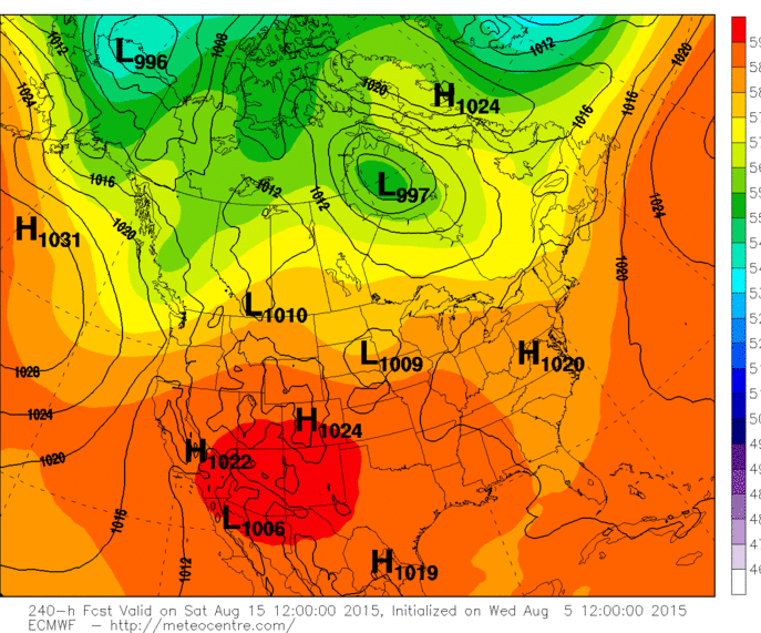
12z EURO sends the worst of the heat to the 4 corners area. That is where it belongs:

Image
0 likes   

Brent
S2K Supporter
S2K Supporter
Posts: 38088
Age: 36
Joined: Sun May 16, 2004 10:30 pm
Location: Tulsa Oklahoma
Contact:

Re: Re:

#318 Postby Brent » Wed Aug 05, 2015 5:01 pm

Tireman4 wrote:
Texas Snowman wrote::uarrow: He's having his fun now. It's his time of the year. In a few months, not so much! :D


But the question is...will we survive the next two months...LOL


2 months? Better be closer to a month. :roll:
0 likes   
#neversummer

User avatar
Tireman4
S2K Supporter
S2K Supporter
Posts: 5853
Age: 59
Joined: Fri Jun 30, 2006 1:08 pm
Location: Humble, Texas
Contact:

Re: Re:

#319 Postby Tireman4 » Wed Aug 05, 2015 5:45 pm

Brent wrote:
Tireman4 wrote:
Texas Snowman wrote::uarrow: He's having his fun now. It's his time of the year. In a few months, not so much! :D


But the question is...will we survive the next two months...LOL


2 months? Better be closer to a month. :roll:


Well I am thinking climo.so September 25....
0 likes   

User avatar
Ptarmigan
Category 5
Category 5
Posts: 5313
Joined: Wed Aug 16, 2006 9:06 pm

Re: Texas Summer-2015

#320 Postby Ptarmigan » Wed Aug 05, 2015 10:39 pm

wxman57 wrote:And, speaking of me, here are a few meteograms from the 12Z GFS. Kind of chilly in Austin next Monday compared to Houston. Core of warm air appears to be centered south of Dallas and east of Austin.

Houston:
Image

Dallas/Ft. Worth:
Image

Austin:
Image


The Cockroach Ridge returns. :grr:
0 likes   


Return to “USA & Caribbean Weather”

Who is online

Users browsing this forum: Google Adsense [Bot] and 18 guests