Texas Summer 2023
Moderator: S2k Moderators
Forum rules

The posts in this forum are NOT official forecast and should not be used as such. They are just the opinion of the poster and may or may not be backed by sound meteorological data. They are NOT endorsed by any professional institution or STORM2K.
-
bubba hotep

- S2K Supporter

- Posts: 6014
- Joined: Wed Dec 28, 2016 1:00 am
- Location: Collin County Texas
Re: Texas Summer 2023

Mesoscale Discussion 1089
NWS Storm Prediction Center Norman OK
0844 PM CDT Thu Jun 15 2023
Areas affected...far southern Oklahoma and portions of North Texas
Concerning...Tornado Watch 309...
Valid 160144Z - 160315Z
The severe weather threat for Tornado Watch 309 continues.
SUMMARY...A cluster of storms including several supercells across
the northern half of WW 309 should continue southeastward this
evening with a threat for damaging winds and a couple of tornadoes.
DISCUSSION...As of 0130z, several long-lived supercells were ongoing
across northern portions of WW309. Located along an effective warm
front near the Red River, area VADs show relatively large low-level
hodographs with 0-1km SRH of 150-200 m2/s2. As these supercells
continue southeastward, largely untouched buoyancy (4000-5000 J/kg
of MLCAPE) and the enhanced low-level shear should support a
continued threat for a couple of tornadoes for a few more hours this
evening. Some upscale growth/additional storm development has been
noted over the last 1-2 hours. The damaging wind threat may increase
this evening as storm interactions and upscale growth increase with
the intensifying low-level jet. Given the very favorable CAPE/shear
parameter space, the storms should continue southeast for several
more hours approaching the eastern edge of WW309 around 0300z.
..Lyons.. 06/16/2023
...Please see www.spc.noaa.gov for graphic product...
ATTN...WFO...SHV...TSA...FWD...OUN...
0 likes
Winter time post are almost exclusively focused on the DFW area.
-
rwfromkansas
- Category 5

- Posts: 3038
- Joined: Sat Aug 27, 2005 12:47 am
- Location: North Fort Worth
Re: Texas Summer 2023
A Facebook friend grew up in Perryton and knew the person who died. Sad.
0 likes
-
bubba hotep
- S2K Supporter
- Posts: 6014
- Joined: Wed Dec 28, 2016 1:00 am
- Location: Collin County Texas
Re: Texas Summer 2023
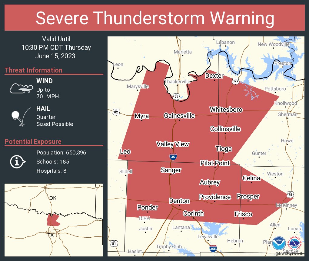
Still a Tornado Warning for Collin but this new Svr Tstorm warning for 70 mph winds for Denton County
0 likes
Winter time post are almost exclusively focused on the DFW area.
-
Texas Snowman

- Storm2k Moderator

- Posts: 6197
- Joined: Fri Jan 25, 2008 11:29 am
- Location: Denison, Texas
Re: Texas Summer 2023
Severe Weather Statement
National Weather Service Fort Worth TX
945 PM CDT Thu Jun 15 2023
TXC085-147-181-160315-
/O.CON.KFWD.TO.W.0058.000000T0000Z-230616T0315Z/
Collin TX-Grayson TX-Fannin TX-
945 PM CDT Thu Jun 15 2023
...A TORNADO WARNING REMAINS IN EFFECT UNTIL 1015 PM CDT FOR
NORTHEASTERN COLLIN...SOUTHEASTERN GRAYSON AND SOUTHWESTERN FANNIN
COUNTIES...
At 945 PM CDT, a severe thunderstorm capable of producing a tornado
was located over Melissa, moving southeast at 30 mph.
HAZARD...Tornado and half dollar size hail.
SOURCE...Radar indicated rotation.
IMPACT...Flying debris will be dangerous to those caught without
shelter. Mobile homes will be damaged or destroyed. Damage
to roofs, windows, and vehicles will occur. Tree damage is
likely.
PRECAUTIONARY/PREPAREDNESS ACTIONS...
TAKE COVER NOW! If you are outdoors, in a mobile home, or in a
vehicle, move to the closest substantial shelter now! Get to an
interior room on the lowest floor of a sturdy building and avoid
windows.
&&
1 likes
The above post and any post by Texas Snowman is NOT an official forecast and should not be used as such. It is just the opinion of the poster and may or may not be backed by sound meteorological data. It is NOT endorsed by any professional institution including storm2k.org. For official information, please refer to NWS products.
-
bubba hotep
- S2K Supporter
- Posts: 6014
- Joined: Wed Dec 28, 2016 1:00 am
- Location: Collin County Texas
Re: Texas Summer 2023
Surface winds are ripping pretty good out of the south IMBY. That would be backed relative to storm motion.
0 likes
Winter time post are almost exclusively focused on the DFW area.
-
bubba hotep
- S2K Supporter
- Posts: 6014
- Joined: Wed Dec 28, 2016 1:00 am
- Location: Collin County Texas
Re: Texas Summer 2023

Mesoscale Precipitation Discussion 0496
NWS Weather Prediction Center College Park MD
1049 PM EDT Thu Jun 15 2023
Areas affected...Portions of the Red River Valley of the South
Concerning...Heavy rainfall...Flash flooding possible
Valid 160248Z - 160848Z
SUMMARY...Well-organized showers and thunderstorms with very heavy
rainfall rates coupled with concerns for cell-mergers and
repeating cell-activity over the next several hours will foster
concerns for additional isolated instances of flash flooding.
DISCUSSION...The latest GOES-16 IR satellite imagery shows
clusters of strong to severe thunderstorms with very cold
convective tops organizing and advancing off to the east-southeast
across the Red River Valley of the South. This is all in
association with a rather strong shortwave trough ejecting out
across the southern Plains which is interacting with a
well-defined quasi-stationary front and the pooling of an
extremely unstable and very moist airmass along it.
In fact, MLCAPE values along and south of the front are on the
order of 5000 TO 5500 J/kg, and with PWs on the order of 1.75
inches. Surface dewpoints are as high as the mid to upper-70s
across much of north-central to northeast TX. All of this coupled
with very strong effective bulk shear values (60 to 80 kts) has
already been fostering long-lived supercell activity, and over the
next few hours, there will likely be some cell-merger activity and
upscale growth of convection into a larger scale and
forward-propagating MCS.
As these cell-mergers occur, and aside from well-defined severe
weather hazards (see SPC's latest MDs for more details), there
will be locally extreme rainfall rate potential with these
evolving and consolidating supercells. An increasing low-level jet
this evening will maintain a well-defined and extremely favorable
moisture/instability transport regime for convective sustenance
going well into the overnight hours, and especially with the level
of shear that is in place.
Expect some rainfall rates to easily exceed 2 inches/hour with the
stronger supercells. Some localized 3 to 5 inch rainfall totals
cannot be ruled out where some of these cell-mergers occur and
locally repeat over the same area over the next several hours.
Based on this, there will be a concern for at least isolated
instances of flash flooding.
Orrison
ATTN...WFO...FWD...OUN...SHV...TSA...
ATTN...RFC...ABRFC...LMRFC...WGRFC...NWC...
0 likes
Winter time post are almost exclusively focused on the DFW area.
-
bubba hotep
- S2K Supporter
- Posts: 6014
- Joined: Wed Dec 28, 2016 1:00 am
- Location: Collin County Texas
Re: Texas Summer 2023
Looks like the radar indicated tornado crossed the lake north of MBY. Constant lightning and low level clouds still streaming north.
0 likes
Winter time post are almost exclusively focused on the DFW area.
-
WeatherNewbie
- Tropical Storm

- Posts: 235
- Joined: Mon Mar 22, 2010 3:42 pm
- Location: Richardson, Texas
Re: Texas Summer 2023
Sirens going off in Far North Dallas/southern Richardson, but there isn't anything within 20 miles of us. 
1 likes
The above post is NOT an official forecast and should not be used as such. It is just the opinion of the poster and may or may not be backed by sound meteorological data. It is NOT endorsed by any professional institution including storm2k.org. For official information, please refer to NWS products.


Re: Texas Summer 2023
I don't see anything nearby either. Eventually the storms may get into north dallas.
https://twitter.com/DallasOEM/status/1669547361306136576
https://twitter.com/DallasOEM/status/1669547361306136576
1 likes
-
HockeyTx82
- S2K Supporter
- Posts: 2795
- Joined: Tue Oct 27, 2009 11:17 am
- Location: Ponder, TX
Re: Texas Summer 2023
WeatherNewbie wrote:Sirens going off in Far North Dallas/southern Richardson, but there isn't anything within 20 miles of us.
You can never be too careful.....
0 likes
Don't hold me accountable for anything I post on this forum. Leave the real forecasting up to the professionals.
Location: Ponder, TX (all observation posts are this location unless otherwise noted)
Location: Ponder, TX (all observation posts are this location unless otherwise noted)
-
bubba hotep
- S2K Supporter
- Posts: 6014
- Joined: Wed Dec 28, 2016 1:00 am
- Location: Collin County Texas
Re: Texas Summer 2023
WeatherNewbie wrote:Sirens going off in Far North Dallas/southern Richardson, but there isn't anything within 20 miles of us.
Uncanny, storms spit an outflow and then took on more of an eastern motion missing most of DFW.
0 likes
Winter time post are almost exclusively focused on the DFW area.
-
rwfromkansas
- Category 5
- Posts: 3038
- Joined: Sat Aug 27, 2005 12:47 am
- Location: North Fort Worth
Re: Texas Summer 2023
Heck, it may even go east of Dallas County entirely. They jumped the gun there. I am a little concerned there is some back-building along the Red River. If that turns, that would pose a greater threat.
3 likes
-
bubba hotep
- S2K Supporter
- Posts: 6014
- Joined: Wed Dec 28, 2016 1:00 am
- Location: Collin County Texas
Re: Texas Summer 2023
rwfromkansas wrote:Heck, it may even go east of Dallas County entirely. They jumped the gun there. I am a little concerned there is some back-building along the Red River. If that turns, that would pose a greater threat.
That should be elevated, given the massive outflow; this batch just dropped. Also, I'm sure they will find some way to miss all of us lol
0 likes
Winter time post are almost exclusively focused on the DFW area.
-
ElectricStorm

- Category 5
- Posts: 5147
- Age: 25
- Joined: Tue Aug 13, 2019 11:23 pm
- Location: Norman, OK
Re: Texas Summer 2023
Decent meso on that cell near Bowie, decent chance it goes tor warned soon imo
1 likes
B.S Meteorology, University of Oklahoma '25
Please refer to the NHC, NWS, or SPC for official information.
Please refer to the NHC, NWS, or SPC for official information.
-
rwfromkansas
- Category 5
- Posts: 3038
- Joined: Sat Aug 27, 2005 12:47 am
- Location: North Fort Worth
Re: Texas Summer 2023
3 fatalities in Perryton now, with 2 missing.
This is a huge loss for such a small community.
This is a huge loss for such a small community.
0 likes
-
WeatherNewbie
- Tropical Storm
- Posts: 235
- Joined: Mon Mar 22, 2010 3:42 pm
- Location: Richardson, Texas
Re: Texas Summer 2023
bubba hotep wrote:rwfromkansas wrote:Heck, it may even go east of Dallas County entirely. They jumped the gun there. I am a little concerned there is some back-building along the Red River. If that turns, that would pose a greater threat.
That should be elevated, given the massive outflow; this batch just dropped. Also, I'm sure they will find some way to miss all of us lol
Don't think Dallas County saw a single raindrop. Definitely jumped the gun on the sirens.
2 likes
The above post is NOT an official forecast and should not be used as such. It is just the opinion of the poster and may or may not be backed by sound meteorological data. It is NOT endorsed by any professional institution including storm2k.org. For official information, please refer to NWS products.

Re: Texas Summer 2023
The lightning last night was wild. Lots of lightning and loud thunder for almost an hour before it arrived (around midnight). Then a constant CG barrage for an hour it seemed. One knocked out power to my neighborhood. Probably had 60 mph gusts. I don't know if my weather station will give me the rain total while power is out, but I easily had 2"+.
I'm out and about early this morning. Most places around here are still without power.
I'm out and about early this morning. Most places around here are still without power.
2 likes
-
bubba hotep
- S2K Supporter
- Posts: 6014
- Joined: Wed Dec 28, 2016 1:00 am
- Location: Collin County Texas
Re: Texas Summer 2023
WeatherNewbie wrote:bubba hotep wrote:rwfromkansas wrote:Heck, it may even go east of Dallas County entirely. They jumped the gun there. I am a little concerned there is some back-building along the Red River. If that turns, that would pose a greater threat.
That should be elevated, given the massive outflow; this batch just dropped. Also, I'm sure they will find some way to miss all of us lol
Don't think Dallas County saw a single raindrop. Definitely jumped the gun on the sirens.
Can't really blame them. Those storms were tracking toward Dallas before shifting eastward at the last minute.
1 likes
Winter time post are almost exclusively focused on the DFW area.
-
bubba hotep
- S2K Supporter
- Posts: 6014
- Joined: Wed Dec 28, 2016 1:00 am
- Location: Collin County Texas
Re: Texas Summer 2023
12z HRRR might be trending towards a better setup for widespread NTX rain on Saturday. Storms fire well west of DFW and then build upscale into clusters as they enter DFW and then finally to a MCS farther east.
0 likes
Winter time post are almost exclusively focused on the DFW area.
Return to “USA & Caribbean Weather”
Who is online
Users browsing this forum: AnnularCane and 118 guests