Texas Summer - 2014

U.S. & Caribbean Weather Discussions and Severe Weather Events

Moderator: S2k Moderators

Forum rules

The posts in this forum are NOT official forecast and should not be used as such. They are just the opinion of the poster and may or may not be backed by sound meteorological data. They are NOT endorsed by any professional institution or STORM2K.

Help Support Storm2K
Message
Author
User avatar
Houstonia
S2K Supporter
S2K Supporter
Posts: 829
Age: 60
Joined: Fri Oct 11, 2002 9:45 am
Location: Sharpstown, Houston, Harris County, Southeast Texas.

Re: Texas Summer - 2014

#241 Postby Houstonia » Wed Jun 25, 2014 4:05 pm

Okay - how many think that that mass that moved off into the Gulf is going to sit there and become some kind of tropical mess? It's already tropical in nature... I don't back it up with any facts - just a long history of watching things move off over water and do weird things! :lol:

AFD for Hou/Gal this afternoon - "less bullish" on rain chances?


AREA FORECAST DISCUSSION
NATIONAL WEATHER SERVICE HOUSTON/GALVESTON TX
320 PM CDT WED JUN 25 2014

.DISCUSSION...
POCKETS OF HEAVY RAIN...BETWEEN 3 AND 5 INCHES FELL OVER THE
NORTHWEST ZONES FROM CALDWELL TO BRYAN TO CROCKETT WITH
CONSIDERABLY LIGHTER RAIN TO THE SOUTH AND SOUTHEAST. THE MORNING
CONVECTION THAT ROLLED THROUGH HOUSTON STABILIZED THINGS AND SENT
A LARGE OUTFLOW BOUNDARY INTO THE GULF. A LARGE MCS DEVELOPED ON
THE OUTFLOW BOUNDARY AND THIS FEATURE CUT OFF THE INFLOW AND
PRODUCED THICK CLOUD COVER TO RETARD HEATING. NOT EXPECTING MUCH
IN THE WAY OF REDEVELOPMENT THIS EVENING AS CLOUDS WILL LINGER
THROUGH THE REST OF THE AFTN...LIMITING HEATING. THAT SAID...
CLOUDS HAVE CLEARED OVER WESTERN LOUISIANA AND WEST OF MATAGORDA
BAY. BOTH AREAS SHOW INCREASING SHRA/TSRA COVERAGE SO NEED TO
WATCH CLEARING TREND THIS AFTERNOON. ANY APPRECIABLE HEATING WILL
TRIGGER SHRA/TSRA DEVELOPMENT. MODEL GUIDANCE LESS BULLISH WITH
RAIN CHANCES OVERNIGHT AND THURSDAY BUT NOT SURE WHY.
PW VALUES
ARE PROGGED TO REMAIN NEAR 2.00 INCHES WITH CONVECTIVE TEMPS IN
THE MIDDLE 80S. THE ECMWF MAINTAINS SOME UPPER LEVEL DIVERGENCE
ACROSS EAST TEXAS ON THURSDAY WHILE THE GFS SHOWS MORE OF A
CONFLUENT FLOW IN THE AFTN. WILL LEAN TOWARD THE ECMWF AND
MAINTAIN LIKELY POPS AND MENTION LOCALLY HEAVY RAIN SINCE THERE IS
SOME POTENTIAL FOR ADDITIONAL HEAVY RAIN. CONSIDERED A FLASH FLOOD
WATCH BUT AREAS THAT RECEIVED HEAVY RAIN TODAY DID NOT RECEIVE
MUCH RAIN IN PRIOR DAYS AND THE AREAS THAT RECEIVED HEAVY RAIN
YESTERDAY DID NOT RECEIVE MUCH RAINFALL TODAY. FLASH FLOOD
GUIDANCE IS STILL REASONABLY HIGH SO WILL FOREGO THE WATCH AT THIS
TIME. SHORT TERM GUIDANCE IS TRENDING DRIER FOR THURSDAY SO IT IS
WITH SHAKY CONFIDENCE THAT LOCALLY HEAVY RAIN IS MENTIONED.

PW VALUES ARE PROGGED TO BE AROUND 1.90 INCHES ON FRIDAY WHICH IS
STILL PLENTY MOIST. CONVECTIVE TEMPS ARE IN THE UPPER 80S WHICH IS
REACHABLE SO STILL EXPECTING A GOOD CHANCE OF SHRA/TSRA WITH
HEATING. PW VALUES DROP A BIT MORE ON SATURDAY AND FCST SOUNDINGS
SHOW SOME DRY AIR WORKING INTO THE SOUNDING BETWEEN 900-700 MB.
TRIMMED POPS BACK A LITTLE ON SATURDAY. LOOKS LIKE THE UPPER RIDGE
WILL BUILD INTO THE AREA SUN/MON. LOWERED RAIN CHANCES AND RAISED
TEMPS DUE TO INCREASING 850 MB TEMPS AND BUILDING HEIGHTS. 43
0 likes   

User avatar
srainhoutx
S2K Supporter
S2K Supporter
Posts: 6919
Age: 67
Joined: Sun Jan 14, 2007 11:34 am
Location: Haywood County, NC
Contact:

Re: Texas Summer - 2014

#242 Postby srainhoutx » Wed Jun 25, 2014 5:21 pm

From Nesdis:

SATELLITE PRECIPITATION ESTIMATES..DATE/TIME 06/25/14 2209Z
SATELLITE ANALYSIS BRANCH/NESDIS---NPPU---TEL.301-683-1404
LATEST DATA USED: GOES-13: 2130ZVOGT MILLER
.
LOCATION...TEXAS...OKLAHOMA...
.
ATTN WFOS...HGX...FWD...OUN...CRP...EWX...SJT...
ATTN RFCS...ABRFC...WGRFC...
.
EVENT... SLOW-MOVING CONVECTION/ HVY RAIN
.
SATELLITE ANALYSIS AND TRENDS...AS LARGE CONVECTIVE COMPLEX WEAKENS IN THE
NORTHERN GULF, NEW CONVECTION IS FORMING ALONG A SFC OUTFLOW BOUNDARY IN
SOUTHERN AND EASTERN TX/SRN OK. WV IMAGERY SHOWED A S/WV EMBEDDED IN THE
500 MB FLOW LIFTING NWD INTO SOUTHERN TX, LIKELY AIDING IN THE THE NEW
CONVECTIVE FORMATION. UPSTREAM, A 40 KT UL JET IS PUSHING INTO CENTRAL
TX, CREATING AN AREA OF UL DIFFLUENCE IN SOUTH-CENTRAL TX. THE BEST SFC
MOISTURE CONVERGENCE IS IN SOUTHERN TX INTO THE TX GULF COASTAL AREAS. GFS
WEST-NORTHWESTERLY C-VECTORS OPPOSE THE CELL MOTION ESPECIALLY IN
SOUTH-CENTRAL TX.... LEADING TO SLOW-MOVING HVY RAINFALL ACROSS THAT AREA.
.
SHORT TERM OUTLOOK VALID 2210-0110Z...MEDIUM CONFIDENCE FACTOR
IN SHORT TERM OUTLOOK...AREA OF PRIMARY CONCERN IS FOR SOUTH-CENTRAL TX
WHERE ONE FFW HAS ALREADY BEEN ISSUED. BUT AS THE S/WV LIFTS NWD, AND THE
UL JET PUSHES E, EXPECT MORE CONVECTION IN SOUTH-CENTRAL TX INVOF BANDERA
COUNTY (GOES-R EXPERIMENTAL CI ALGORITHM SHOWS ADDITIONAL CONVECTION
FORMING IN THIS AREA AS WELL).... SLOWEST MOVING HVY RAIN SHOULD REMAIN
MAINLY NEAR THE TX GULF COAST AND PTS NW. GIVEN THE HIGH-MOISTURE SOURCE
IN PLACE, 1-2"/HR RATES ARE POSSIBLE WITH THE SLOW-MOVING CONVECTION


Image
0 likes   
Carla/Alicia/Jerry(In The Eye)/Michelle/Charley/Ivan/Dennis/Katrina/Rita/Wilma/Ike/Harvey

Member: National Weather Association
Wx Infinity Forums
http://wxinfinity.com/index.php

Facebook.com/WeatherInfinity
Twitter @WeatherInfinity

User avatar
Ntxw
Storm2k Moderator
Storm2k Moderator
Posts: 22784
Joined: Wed Oct 21, 2009 6:34 pm
Location: DFW, Texas

Re: Texas Summer - 2014

#243 Postby Ntxw » Wed Jun 25, 2014 8:11 pm

It's going to be hard to build heat ridges with this. As in my post yesterday the first heat wave for the country will come early July, we'll probably feel it in the mid to upper 90s before it breaks down, but Texas is not directly under it's influence as we remain under the weakness between the Sonoran and SE ridge.

Image

Everything around here (for summer) is still relatively lush and green. I remember vividly how brown/dying things were not that long ago in summer's past.
0 likes   
The above post and any post by Ntxw is NOT an official forecast and should not be used as such. It is just the opinion of the poster and may or may not be backed by sound meteorological data. It is NOT endorsed by any professional institution including Storm2k. For official information, please refer to NWS products.

  Help support Storm2K!
Help Support Storm2K

User avatar
gboudx
S2K Supporter
S2K Supporter
Posts: 4080
Joined: Thu Sep 04, 2003 1:39 pm
Location: Rockwall, Tx but from Harvey, La

#244 Postby gboudx » Wed Jun 25, 2014 9:09 pm

From jeff:

After a round of morning thunderstorms the air mass inland stabilized while a large convective complex exploded just offshore. This complex helped to “rob” incoming Gulf moisture to inland areas today and held back surface heating with its mid and high level cloud canopy thus keeping the heavy rainfall focused offshore.

Clearing to the SW has resulted in another complex of thunderstorms stretching from Victoria to north of Corpus Christi. 88D indicates upwards of 6 inches of rainfall in the past few hours over Aransas and Refugio Counties. A circulation is clearly noted in the radar loops from San Antonio and Corpus suggesting some sort of mid level vort may be centered somewhere in all the activity between San Antonio and Corpus. Offshore complex over the NW Gulf has weakened considerably in the last few hours and expect air mass over our coastal waters to begin to destabilize with an influx of deep tropical moisture over the western Gulf. Meso models not supporting much development tonight, but given the “vort” off to our WSW and increasing nocturnal speed convergence over the nearshore waters expect activity to begin to fire off in the 100am-400am time period and at least spread toward the coast. This tends to be fairly common with these types of air masses and setups.

Main question becomes if and how far inland any coastal convection will penetrate on Thursday morning. Think main trough axis over SC TX will be closer to SE TX on Thursday morning and this will support a little better inland movement of activity however events in the past tend to favor convection anchoring near the coast or offshore and little inland development (ie today). Meso models are not really handling the potential for development very well and will trend more toward experience in these situations over short term model guidance and go with nearshore development late tonight moving into at least the coastal counties and possibly reaching US 59.

With the trough axis closer tomorrow storm motions may be slower than the last few days. Even with 15-25mph movement we have still been able to see 1-2 inch per hour rainfall rates with the stronger cells. Think motions on Thursday will be in the 10-15mph range and the air mass remains extremely moist so high hourly rainfall rates will be common. Flash Flood Guidance has shown only modest decreases as rains so far have been spotty and not overly concentrated and for the most part think we should be able to handle an additional 2-3 inches without major problems. Some concern for urban areas where tropical rainfall rates can easily overwhelm drainage systems even if the storm total is a couple of inches, but it all falls in 30-45 minutes.

Friday-weekend:
Upper ridging will at least attempt to gain a foothold across the region, but I have my doubts if it will be able to cut off rain chances. GFS drops rain chances from 61% Friday to 25% Saturday which seems a little aggressive with the drying. Models have been struggling with how fast and how strong the sub-tropical ridge builds over the region. Think the ridge will have a harder time gaining a foothold with fairly moist grounds and green vegetation compared to the past several summers and allow at least scattered seabreeze storms each day.

Ridge looks to finally overtake the area early next week, but again looks short lived as a westward moving tropical wave/TUTT low works is way from FL toward TX by the middle to end of next week. This may result in another surge of deep tropical moisture toward the July 3-4 time period with increasing rain chances again.
0 likes   

weatherdude1108
Category 5
Category 5
Posts: 4228
Joined: Tue Dec 13, 2011 1:04 pm
Location: Northwest Austin/Cedar Park, TX

#245 Postby weatherdude1108 » Wed Jun 25, 2014 11:03 pm

We received another 1/2 inch between 8 and 8:30 this evening from a pop up heavy shower over the Weatherdude Center. :D :rain: Lasted 5-10 minutes at most. Five minutes of INTENSE rain. A lot of water in a short time! Warm rain. Definitely had tropical characteristics.
0 likes   

User avatar
JDawg512
Category 5
Category 5
Posts: 1075
Age: 45
Joined: Mon Aug 26, 2013 8:56 pm
Location: Austin
Contact:

Re:

#246 Postby JDawg512 » Wed Jun 25, 2014 11:31 pm

weatherdude1108 wrote:We received another 1/2 inch between 8 and 8:30 this evening from a pop up heavy shower over the Weatherdude Center. :D :rain: Lasted 5-10 minutes at most. Five minutes of INTENSE rain. A lot of water in a short time! Warm rain. Definitely had tropical characteristics.


Yea, same thing occured here in South Austin not far from Soutj Austin Hospital although I have yet to check the amount. That made it 3 rounds of rain today. This mornings storm was very noisy and loud.
0 likes   
Resident Rain Miser

I am a weather hobbyist living 3.5 miles south of Downtown Austin and in no way or fashion should anything I say concerning forecasts be taken seriously. Please check your local NWS for accurate weather forecasting and conditions.

weatherdude1108
Category 5
Category 5
Posts: 4228
Joined: Tue Dec 13, 2011 1:04 pm
Location: Northwest Austin/Cedar Park, TX

Re: Re:

#247 Postby weatherdude1108 » Thu Jun 26, 2014 10:08 am

JDawg512 wrote:
weatherdude1108 wrote:We received another 1/2 inch between 8 and 8:30 this evening from a pop up heavy shower over the Weatherdude Center. :D :rain: Lasted 5-10 minutes at most. Five minutes of INTENSE rain. A lot of water in a short time! Warm rain. Definitely had tropical characteristics.


Yea, same thing occured here in South Austin not far from Soutj Austin Hospital although I have yet to check the amount. That made it 3 rounds of rain today. This mornings storm was very noisy and loud.


Yeah. The trees, shrubs, and grasses are so lush and green around here! Even plants on properties that are usually irrigated, look better and more healthy. Rain water is so much better than tap water. No comparison! Wish this would last the whole Summer.
0 likes   

User avatar
South Texas Storms
Professional-Met
Professional-Met
Posts: 4224
Joined: Thu Jun 24, 2010 12:28 am
Location: Houston, TX

Re: Texas Summer - 2014

#248 Postby South Texas Storms » Thu Jun 26, 2014 11:40 am

Another round of scattered tropical downpours are currently moving across south/central Texas. Rain chances decrease tomorrow.

Image

Uploaded with ImageShack.us
0 likes   

aggiecutter
Category 5
Category 5
Posts: 1753
Joined: Thu Oct 14, 2004 9:22 pm
Location: Texarkana

Re: Texas Summer - 2014

#249 Postby aggiecutter » Thu Jun 26, 2014 3:53 pm

On this day in 2012, Texarkana reported a daily record high of 105.
0 likes   

aggiecutter
Category 5
Category 5
Posts: 1753
Joined: Thu Oct 14, 2004 9:22 pm
Location: Texarkana

#250 Postby aggiecutter » Fri Jun 27, 2014 1:00 pm

Reed Timmer ‏@reedtimmerTVN 1h
Very deep high quality moisture across the southern/central Plains right now. Textbook summer El Niño pattern
0 likes   

User avatar
South Texas Storms
Professional-Met
Professional-Met
Posts: 4224
Joined: Thu Jun 24, 2010 12:28 am
Location: Houston, TX

Re: Texas Summer - 2014

#251 Postby South Texas Storms » Fri Jun 27, 2014 1:01 pm

It has been another wet week across much of Texas and some places received over 5 inches of rain! Unfortunately mostly dry weather is in the forecast for a large part of the state next week after a few more scattered rain showers this weekend.

Image

Uploaded with ImageShack.us
0 likes   

User avatar
JDawg512
Category 5
Category 5
Posts: 1075
Age: 45
Joined: Mon Aug 26, 2013 8:56 pm
Location: Austin
Contact:

Re: Texas Summer - 2014

#252 Postby JDawg512 » Fri Jun 27, 2014 1:07 pm

How does the 4th of July weekend look? Are the models still indicating a wet one or have they backed off?
0 likes   
Resident Rain Miser

I am a weather hobbyist living 3.5 miles south of Downtown Austin and in no way or fashion should anything I say concerning forecasts be taken seriously. Please check your local NWS for accurate weather forecasting and conditions.

weatherguy425
Tropical Storm
Tropical Storm
Posts: 180
Joined: Sun Aug 16, 2009 1:06 pm
Location: Houston, TX > Lubbock, TX > Savannah, GA
Contact:

Re: Texas Summer - 2014

#253 Postby weatherguy425 » Fri Jun 27, 2014 1:09 pm

Eyeing another potential 'sagging cold front' moving out of the Central Plains by the middle of next week. With another potential EPAC system on the way, and any added GOM moisture, this all could bring renewed rain chances mid & late next week. Unless, High pressure, really, really, gains some ground between now and then.
0 likes   

aggiecutter
Category 5
Category 5
Posts: 1753
Joined: Thu Oct 14, 2004 9:22 pm
Location: Texarkana

Re: Texas Summer - 2014

#254 Postby aggiecutter » Fri Jun 27, 2014 3:37 pm

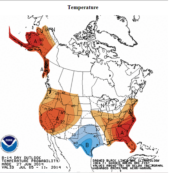
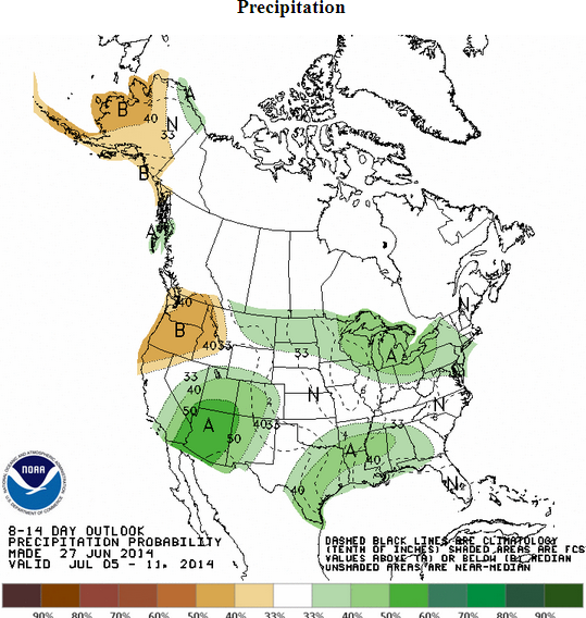
WPC says Texas will be cooler and wetter than normal over the next couple weeks:

Image


Image
0 likes   

gpsnowman
S2K Supporter
S2K Supporter
Posts: 3185
Joined: Fri Jan 07, 2011 10:35 am
Location: Grand Prairie Tx

#255 Postby gpsnowman » Mon Jun 30, 2014 5:15 pm

We are in the ho-hum part of the year. This humidity is disgusting. Coming over the I-20 West hill near Cedar Hill, you could see the thick sticky humidity covering the Metroplex. Thank goodness no 100's.......yet. Dreaming of winter fun. Have to say June has been a good month with rains and no triple digits. Just two more months of this and autumn comes knocking.
0 likes   

weatherdude1108
Category 5
Category 5
Posts: 4228
Joined: Tue Dec 13, 2011 1:04 pm
Location: Northwest Austin/Cedar Park, TX

#256 Postby weatherdude1108 » Mon Jun 30, 2014 10:44 pm

:uarrow:
I have noticed the haze down here the past couple days. Depressing! :cry:
I thought it was just the sun beating down on the widespread moist grounds, creating hazy humidity from recent rains. Looks like it may be our friend/foe the Saharan dust cloud(s) that made the trans-Atlantic Journey to pay us a visit. Fascinating how far it goes, but makes me miss every day without rain and clean air. :roll:

http://www.texasstormchasers.com/2014/0 ... -the-haze/
0 likes   
The preceding post is NOT an official forecast, and should not be used as such. It is only the opinion of the poster and may or may not be backed by sound meteorological data. It is NOT endorsed by any professional institution including storm2k.org. For Official Information please refer to the NHC and NWS products.

User avatar
Ntxw
Storm2k Moderator
Storm2k Moderator
Posts: 22784
Joined: Wed Oct 21, 2009 6:34 pm
Location: DFW, Texas

Re: Texas Summer - 2014

#257 Postby Ntxw » Tue Jul 01, 2014 7:01 am

It's July 1st. We have all survived 1/3rd of summer's assault! June, for the first time in ages, did not record a single 100 degree day at either DFW, Austin, Houston, or San Antonio!

The days continue to grow shorter but we approach the peak of heat. For the month as a whole wall to wall July is the hottest month (August levels off after the second week). There are no signs of any prolonged heat wave, still don't see anything that says 100s. We may sneak one in there but it will be an uphill battle for one. The pattern takes us to about mid July. Given this, statistically and mathematically it is very likely 2014 will end up with the lower percentile for days 100 and over. 2011 streak is almost realistically unobtainable unless we start now and be relentless.

Happy fourth later this week and hope nature gives us all some natural light shows, unless you have outdoor plans.
0 likes   
The above post and any post by Ntxw is NOT an official forecast and should not be used as such. It is just the opinion of the poster and may or may not be backed by sound meteorological data. It is NOT endorsed by any professional institution including Storm2k. For official information, please refer to NWS products.


  Help support Storm2K!

Help Support Storm2K


weatherdude1108
Category 5
Category 5
Posts: 4228
Joined: Tue Dec 13, 2011 1:04 pm
Location: Northwest Austin/Cedar Park, TX

Re: Texas Summer - 2014

#258 Postby weatherdude1108 » Tue Jul 01, 2014 8:42 am

Ntxw wrote:It's July 1st. We have all survived 1/3rd of summer's assault! June, for the first time in ages, did not record a single 100 degree day at either DFW, Austin, Houston, or San Antonio!

The days continue to grow shorter but we approach the peak of heat. For the month as a whole wall to wall July is the hottest month (August levels off after the second week). There are no signs of any prolonged heat wave, still don't see anything that says 100s. We may sneak one in there but it will be an uphill battle for one. The pattern takes us to about mid July. Given this, statistically and mathematically it is very likely 2014 will end up with the lower percentile for days 100 and over. 2011 streak is almost realistically unobtainable unless we start now and be relentless.

Happy fourth later this week and hope nature gives us all some natural light shows, unless you have outdoor plans.

:uarrow:
Yeah, they said on the local weather that this was the first time in four years (2010) that Austin did not reach 100 degrees in June. Love it! :D
0 likes   

weatherdude1108
Category 5
Category 5
Posts: 4228
Joined: Tue Dec 13, 2011 1:04 pm
Location: Northwest Austin/Cedar Park, TX

#259 Postby weatherdude1108 » Tue Jul 01, 2014 11:43 am

Bob Rose posted the stat about not reaching 100 in June since 2010. I wish it were the new norm.

Some June Climate Trivia: It appears the month of June will end with no 100-degree temperatures recorded across our region. This will be the first June since 2010 without any 100 degree readings. In Austin, there were 15 100-degree days in June 2011, 6 100-degree days in June of 2012 and 5 100-degree days in June of 2013. The temperature reached 106 degrees in June 2011, 109 degrees in June 2012 and 108 degrees in June 2013. This June, the hottest temperature recorded has been 95 degrees. At Camp Mabry, the average temperature for the month, with data through June 29th, has been 81.9 degrees, which is 0.3 degrees below normal.

What a difference a year makes!

Bob

http://www.lcra.org/water/river-and-wea ... ather.aspx
0 likes   
The preceding post is NOT an official forecast, and should not be used as such. It is only the opinion of the poster and may or may not be backed by sound meteorological data. It is NOT endorsed by any professional institution including storm2k.org. For Official Information please refer to the NHC and NWS products.

User avatar
dhweather
S2K Supporter
S2K Supporter
Posts: 6199
Joined: Sat Aug 14, 2004 9:29 pm
Location: Heath, TX
Contact:

Re: Texas Summer - 2014

#260 Postby dhweather » Tue Jul 01, 2014 11:59 am

Boy, rain chances look mighty slim through mid July. Jul 1 00Z euro run total precip

Image
0 likes   
The above post and any post by dhweather is NOT an official forecast and should not be used as such. It is just the opinion of the poster and may or may not be backed by sound meteorological data. It is NOT endorsed by any professional institution including storm2k.org. For official information, please refer to NWS products.


Return to “USA & Caribbean Weather”

Who is online

Users browsing this forum: Google Adsense [Bot] and 19 guests