Texas Spring 2020
Moderator: S2k Moderators
Forum rules

The posts in this forum are NOT official forecast and should not be used as such. They are just the opinion of the poster and may or may not be backed by sound meteorological data. They are NOT endorsed by any professional institution or STORM2K.
-
weatherdude1108
- Category 5

- Posts: 4228
- Joined: Tue Dec 13, 2011 1:04 pm
- Location: Northwest Austin/Cedar Park, TX
Re: Texas Spring 2020
Quite the storm. Lots of heavy rain and wind. Tree branches blown down - dead branches, so I got a complimentary tree trim!  0.5" of rain.
4 likes
The preceding post is NOT an official forecast, and should not be used as such. It is only the opinion of the poster and may or may not be backed by sound meteorological data. It is NOT endorsed by any professional institution including storm2k.org. For Official Information please refer to the NHC and NWS products.
-
bubba hotep

- S2K Supporter

- Posts: 6014
- Joined: Wed Dec 28, 2016 1:00 am
- Location: Collin County Texas
Re: Texas Spring 2020
Looks like a couple of days of svr wx and some potential miracle winter wx is bringing this thread back to life!
3 likes
Winter time post are almost exclusively focused on the DFW area.
-
Brent
- S2K Supporter
- Posts: 38755
- Age: 37
- Joined: Sun May 16, 2004 10:30 pm
- Location: Tulsa Oklahoma
- Contact:
Re: Texas Spring 2020
 why not have the most snow ever in April after almost hitting 100
4 likes
#neversummer
-
Haris

- Category 5
- Posts: 1814
- Joined: Mon Nov 27, 2017 8:19 pm
- Location: ( Bee Cave) West Austin, Texas
Re: Texas Spring 2020
weatherdude1108 wrote:Quite the storm. Lots of heavy rain and wind. Tree branches blown down - dead branches, so I got a complimentary tree trim!
Nice to hear that! For most of Central Texas though and especially S of Wil co, this was a very underachieving system. Only .2" at my place. Zero svr reports in Trav Co. Guess that isnt a bad thing
It is frustrating how its so hard to get decent svr wx down here. We will try again for the last time sat
3 likes
Weather geek and a storm spotter in West Austin. Not a degreed meteorologist. Big snow fan. Love rain and cold! Despise heat!
-
bubba hotep
- S2K Supporter
- Posts: 6014
- Joined: Wed Dec 28, 2016 1:00 am
- Location: Collin County Texas
Re: Texas Spring 2020
Euro has been pretty consistent with bulls eyeing DFW this weekend.

2 likes
Winter time post are almost exclusively focused on the DFW area.
-
weatherdude1108
- Category 5
- Posts: 4228
- Joined: Tue Dec 13, 2011 1:04 pm
- Location: Northwest Austin/Cedar Park, TX
Re: Texas Spring 2020
Haris wrote:weatherdude1108 wrote:Quite the storm. Lots of heavy rain and wind. Tree branches blown down - dead branches, so I got a complimentary tree trim!
Nice to hear that! For most of Central Texas though and especially S of Wil co, this was a very underachieving system. Only .2" at my place. Zero svr reports in Trav Co. Guess that isnt a bad thing
It is frustrating how its so hard to get decent svr wx down here. We will try again for the last time sat
Yeah. I'm glad it didn't hail though. I was out in backyard with the dog when the wind first picked up. Twigs falling everywhere, instant temperature drop!
2 likes
The preceding post is NOT an official forecast, and should not be used as such. It is only the opinion of the poster and may or may not be backed by sound meteorological data. It is NOT endorsed by any professional institution including storm2k.org. For Official Information please refer to the NHC and NWS products.
-
weatherdude1108
- Category 5
- Posts: 4228
- Joined: Tue Dec 13, 2011 1:04 pm
- Location: Northwest Austin/Cedar Park, TX
Re: Texas Spring 2020
weatherdude1108 wrote:Haris wrote:weatherdude1108 wrote:Quite the storm. Lots of heavy rain and wind. Tree branches blown down - dead branches, so I got a complimentary tree trim!
Nice to hear that! For most of Central Texas though and especially S of Wil co, this was a very underachieving system. Only .2" at my place. Zero svr reports in Trav Co. Guess that isnt a bad thing
It is frustrating how its so hard to get decent svr wx down here. We will try again for the last time sat
Yeah. I'm glad it didn't hail though! The way the weather service kept hyping it, I was wondering.
I was out in backyard with the dog when the wind first picked up. Twigs falling everywhere, instant temperature drop!
1 likes
The preceding post is NOT an official forecast, and should not be used as such. It is only the opinion of the poster and may or may not be backed by sound meteorological data. It is NOT endorsed by any professional institution including storm2k.org. For Official Information please refer to the NHC and NWS products.
-
captainbarbossa19

- Professional-Met

- Posts: 1094
- Age: 27
- Joined: Wed Aug 21, 2019 11:09 pm
- Location: Beaumont, TX
Re: Texas Spring 2020
weatherdude1108 wrote:Quite the storm. Lots of heavy rain and wind. Tree branches blown down - dead branches, so I got a complimentary tree trim!
Glad you got rain! The storm died before it reached me. Just a few rain drops fell. I just hope the weather isn't too harsh this weekend and it's just rain.
2 likes
-
Brent
- S2K Supporter
- Posts: 38755
- Age: 37
- Joined: Sun May 16, 2004 10:30 pm
- Location: Tulsa Oklahoma
- Contact:
Re: Texas Spring 2020
Dunno about snow or the severe weather but this will be a shock to the system 

4 likes
#neversummer
-
TheProfessor

- Professional-Met
- Posts: 3506
- Age: 29
- Joined: Tue Dec 03, 2013 10:56 am
- Location: Wichita, Kansas
Re: Texas Spring 2020
So that storm that hit Austin and College Station made it all the way here and knocked out power for me for 6 hours.
2 likes
An alumnus of The Ohio State University.
Your local National Weather Service office is your best source for weather information.
Your local National Weather Service office is your best source for weather information.
Re: Texas Spring 2020
Gorgeous spring day today. Cool breeze, bright sun and no humidity. Air smells good with the windows open. Looking forward to winter's last breath next week after the rain this weekend. Something to enjoy in this time of uncertainty.
2 likes
-
vbhoutex

- Storm2k Executive

- Posts: 29149
- Age: 74
- Joined: Wed Oct 09, 2002 11:31 pm
- Location: Cypress, TX
- Contact:
Re: Texas Spring 2020
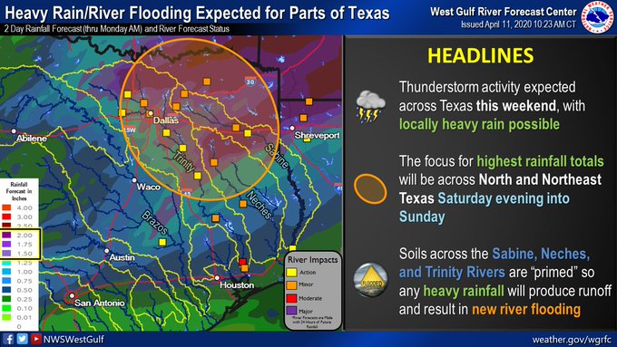
Jeff Lindner's take on this weekends weather:
Severe weather will be possible over a large portion of TX on Saturday into early Sunday.
Surface cool front has stalled over the Gulf waters this morning while a cooler and drier air mass has moved into the region from the NE. Today will feature mostly cloudy skies as WSW winds aloft ride over the top of the surface cooler air mass. Upper level storm system over the SW US will begin to move eastward toward TX later today and this will begin to set the stage of a widespread and potentially significant severe weather outbreak across the southern US Saturday into Sunday.
As the upper level low pressure system moves into New Mexico later today into Saturday, the surface front off the coast will begin to move northward as a warm front. A disturbance in the sub-tropical jet aloft over the region will move across SE TX on Saturday and interact with the northward moving warm front. Expect scattered showers and thunderstorms to develop over the region midday through the afternoon hours on Saturday. By Saturday evening the warm front will have cleared the entire are to the north and a warm and unstable air mass will be in place over SE TX. However there is also likely to be a building cap over the region from the SW to the NE by Saturday evening and this feature will play a big part on where and if there will be any severe storms on Sunday morning across the region.
Main storm system ejects across TX Saturday night and early Sunday. Parameters are certainly in place for strong to severe storms over SE TX with this feature, but as mentioned, capping in the mid levels could prevent severe storms from developing especially south of I-10 where the cap will be the strongest. For now will favor areas north of I-10 for a chance of severe storms early Sunday morning, even though SPC has the entire area in a slight risk. There is also a low potential around sunrise Sunday for a few supercells to develop near the upper TX coast…given the shear in place these storms could have a tornado threat, but the overall chance that they develop especially given the capping in that area appears low. A significant severe weather and tornado outbreak is likely across LA, MS, AL on Sunday including the threat for long tracked violent tornadoes.
Sunday evening a strong cold front will sweep across the region ushering in a much cooler and drier air mass. This air mass will clear out clouds and humidity for several days with lows in the 40’s and 50’s and highs in the 60’s and 70’s for the early to mid part of next week.
1 likes
Skywarn, C.E.R.T.
Please click below to donate to STORM2K to help with the expenses of keeping the site going:

Please click below to donate to STORM2K to help with the expenses of keeping the site going:

-
captainbarbossa19
- Professional-Met
- Posts: 1094
- Age: 27
- Joined: Wed Aug 21, 2019 11:09 pm
- Location: Beaumont, TX
Re: Texas Spring 2020
TheProfessor wrote:So that storm that hit Austin and College Station made it all the way here and knocked out power for me for 6 hours.
Are you in Louisiana?
0 likes
-
captainbarbossa19
- Professional-Met
- Posts: 1094
- Age: 27
- Joined: Wed Aug 21, 2019 11:09 pm
- Location: Beaumont, TX
Re: Texas Spring 2020
Cpv17 wrote:South of I-10 I’m not expecting much with this weekends event.
Don't discount anything yet. From what I have witnessed, the models have not been very good with depicting precipitation amounts and the areas that receive it. For example, yesterday many models showed the first line of storms were going to impact my area. Part of the line died once it reached western Liberty County. I just got a few rain drops out of the line. The funny part is that a secondary line formed later that evening and hit my location. I picked up almost 0.75 inches. You just never know. Models are more like guides; they are far from perfect and will more than likely never achieve perfection.
1 likes
-
cheezyWXguy

- Category 5
- Posts: 6282
- Joined: Mon Feb 13, 2006 12:29 am
- Location: Dallas, TX
Re: Texas Spring 2020
captainbarbossa19 wrote:Cpv17 wrote:South of I-10 I’m not expecting much with this weekends event.
Don't discount anything yet. From what I have witnessed, the models have not been very good with depicting precipitation amounts and the areas that receive it. For example, yesterday many models showed the first line of storms were going to impact my area. Part of the line died once it reached western Liberty County. I just got a few rain drops out of the line. The funny part is that a secondary line formed later that evening and hit my location. I picked up almost 0.75 inches. You just never know. Models are more like guides; they are far from perfect and will more than likely never achieve perfection.
Yeah there still seems to be quite a bit of disagreement among the models for how this will play out, at least for Texas. The NAM is much more ambitious on daytime convection for north and central Texas during the day Saturday, with a very strong cap overnight that drowns out most of the severe weather threat. The euro, on the other hand see a bit slower and shows less daytime convection and quite a high coverage during the overnight into Sunday morning period. The HRRR doesn’t go quite far enough out, but doesn’t show anywhere near the same level of storm coverage during the day Saturday as the NAM, but I’ve noticed it tends to underdo storm coverage while overdoing the discrete-ness of the storms it does show. We’ll see.
3 likes
-
captainbarbossa19
- Professional-Met
- Posts: 1094
- Age: 27
- Joined: Wed Aug 21, 2019 11:09 pm
- Location: Beaumont, TX
Re: Texas Spring 2020
cheezyWXguy wrote:captainbarbossa19 wrote:Cpv17 wrote:South of I-10 I’m not expecting much with this weekends event.
Don't discount anything yet. From what I have witnessed, the models have not been very good with depicting precipitation amounts and the areas that receive it. For example, yesterday many models showed the first line of storms were going to impact my area. Part of the line died once it reached western Liberty County. I just got a few rain drops out of the line. The funny part is that a secondary line formed later that evening and hit my location. I picked up almost 0.75 inches. You just never know. Models are more like guides; they are far from perfect and will more than likely never achieve perfection.
Yeah there still seems to be quite a bit of disagreement among the models for how this will play out, at least for Texas. The NAM is much more ambitious on daytime convection for north and central Texas during the day Saturday, with a very strong cap overnight that drowns out most of the severe weather threat. The euro, on the other hand see a bit slower and shows less daytime convection and quite a high coverage during the overnight into Sunday morning period. The HRRR doesn’t go quite far enough out, but doesn’t show anywhere near the same level of storm coverage during the day Saturday as the NAM, but I’ve noticed it tends to underdo storm coverage while overdoing the discrete-ness of the storms it does show. We’ll see.
Yes, I looked at an HRRR model run yesterday afternoon and it did not perform very well in my area. It sometimes does very well, but it does have its flaws just like any other model.
0 likes
-
TheProfessor
- Professional-Met
- Posts: 3506
- Age: 29
- Joined: Tue Dec 03, 2013 10:56 am
- Location: Wichita, Kansas
Re: Texas Spring 2020
captainbarbossa19 wrote:TheProfessor wrote:So that storm that hit Austin and College Station made it all the way here and knocked out power for me for 6 hours.
Are you in Louisiana?
Yep, north of lake Pontchartrain.
1 likes
An alumnus of The Ohio State University.
Your local National Weather Service office is your best source for weather information.
Your local National Weather Service office is your best source for weather information.

-
bubba hotep
- S2K Supporter
- Posts: 6014
- Joined: Wed Dec 28, 2016 1:00 am
- Location: Collin County Texas
Re: Texas Spring 2020
In addition to storms there will be a good bit of rain across N. Texas
4 likes
Winter time post are almost exclusively focused on the DFW area.
Return to “USA & Caribbean Weather”
Who is online
Users browsing this forum: No registered users and 134 guests