

Texas Summer - 2014
Moderator: S2k Moderators
Forum rules

The posts in this forum are NOT official forecast and should not be used as such. They are just the opinion of the poster and may or may not be backed by sound meteorological data. They are NOT endorsed by any professional institution or STORM2K.
Re: Texas Summer - 2014
Similar to the past several evenings clusters of storms have congealed into an MCS or similar feature in the Panhandle and moved S/SE. Either they kept going against guidance or they have been catalysts for daytime convection once they cross the state. We have another one now up there, lets see what they do tomorrow.
0 likes
The above post and any post by Ntxw is NOT an official forecast and should not be used as such. It is just the opinion of the poster and may or may not be backed by sound meteorological data. It is NOT endorsed by any professional institution including Storm2k. For official information, please refer to NWS products.
Help support Storm2K!
-
weatherdude1108
- Category 5

- Posts: 4228
- Joined: Tue Dec 13, 2011 1:04 pm
- Location: Northwest Austin/Cedar Park, TX
Re: Texas Summer - 2014
Ntxw wrote:Similar to the past several evenings clusters of storms have congealed into an MCS or similar feature in the Panhandle and moved S/SE. Either they kept going against guidance or they have been catalysts for daytime convection once they cross the state. We have another one now up there, lets see what they do tomorrow.
Love it!
0 likes
-
srainhoutx

- S2K Supporter

- Posts: 6919
- Age: 68
- Joined: Sun Jan 14, 2007 11:34 am
- Location: Haywood County, NC
- Contact:
Re: Texas Summer - 2014
From Nesdis:
SATELLITE PRECIPITATION ESTIMATES..DATE/TIME 06/25/14 1154Z
SATELLITE ANALYSIS BRANCH/NESDIS---NPPU---TEL.301-683-1404
LATEST DATA USED: GOES-EAST 1145Z GG
.
LOCATION...SW LOUISIANA...SE TEXAS...
.
ATTN WFOS...LCH...HGX...CRP...EWX...
ATTN RFCS...LMRFC...WGRFC...
.
EVENT...ISOLATED FF THREAT ALONG GULF BREEZE CONVERGENCE BOUNDARIES.
.
SHORT TERM OUTLOOK VALID 1200-1600Z...MEDIUM-HIGH CONFIDENCE FACTOR
IN SHORT TERM OUTLOOK...SATURATED LOW LEVELS WITH PWS IN EXCESS OF 2.0"
OVERLAY AN AREA THAT RECEIVED SUFFICIENT RAINFALL YESTERDAY TO LOWER
FFG VALUES INTO A RANGE THAT MAY BE EXCEEDED WITH TODAY'S ACTIVE GULF
BREEZE ALONG THE TX AND LA COAST. THIS SUBTLY ENHANCED BY WEAK UPPER
LEVEL TROFING ALLOWING FOR SOME ADDITIONAL WEAKER CONVECTION OVER THE
HILL COUNTRY AS WELL. WITH THIS WEAK TROF AND PRESSURE FALLS AHEAD
OF CONVECTIVE COMPLEX IN N TX... IS ALLOWING FOR INCREASED ONSHORE FLOW
AIDING MST FLUX TO ENVIRONMENT WITH 3000-4000 J/KG OF CAPES.
CURRENTLY ALONG THE WESTERN PORTION OF THE DISCUSSION AREA... DEEP
-65C COMPLEX HAS DEVELOPED OVER DEWITT AND KARNES COUNTY...
500-1000MB THICKNESS ANALYSIS SHOWS THIS AREA WITHIN THE CONVERGENT
TROF... INCREASING PROPAGATION VECTORS PARALLEL TO THE STRONG ONSHORE
FLOW WHICH NEARLY CANCELS OUT ALLOWING FOR REPEAT CONVECTION TO BUILD
OVER THE SAME AREAS. WITH HIGH PWS... RATES OF 1.5-2" ARE POSSIBLE.
FURTHER EXPANSION OF THIS SYTLE OF DEVELOPING IS PSBL INTO THE HILL
COUNTY AND FURTHER ENE UP THE GULF BREEZE.
FURTHER EAST ALONG THE TX/LA BOUNDARY... BETTER VEERED LOW LEVEL
FLOW IS BUILDING STRONGER SFC AND LOW LEVEL MST CONVERGENCE FOR
STRONGER/DEEPER/MORE EFFICIENT RAIN PRODUCTION WITH NUMEROUS CELLS TO -70C
AND COOLER....THOUGH INSTABILITIES ARE SLIGHTLY LOWER HERE... ONSHORE
MST FLUX AND SE PROPAGATION VECTORS COULD ALLOW FOR NEARLY STATIONARY
CONVECTIVE COMPLEX OVER THE NEXT FEW HOURS... THOUGH COLD POOL PROPAGATION
MAY NEGATE SOME OF THE TRAINING ALSO LIMITING FF THREAT TO ISOLATED.
0 likes
Carla/Alicia/Jerry(In The Eye)/Michelle/Charley/Ivan/Dennis/Katrina/Rita/Wilma/Ike/Harvey
Member: National Weather Association
Wx Infinity Forums
http://wxinfinity.com/index.php
Facebook.com/WeatherInfinity
Twitter @WeatherInfinity
Member: National Weather Association
Wx Infinity Forums
http://wxinfinity.com/index.php
Facebook.com/WeatherInfinity
Twitter @WeatherInfinity
Just incredible the influx of moisture into Texas. Get under any shower and it pours. It's nice being inbetween ridges for a summer instead of having one over you.
0 likes
The above post and any post by Ntxw is NOT an official forecast and should not be used as such. It is just the opinion of the poster and may or may not be backed by sound meteorological data. It is NOT endorsed by any professional institution including Storm2k. For official information, please refer to NWS products.
Help support Storm2K!
Help support Storm2K!
-
Portastorm

- Storm2k Moderator

- Posts: 9955
- Age: 63
- Joined: Fri Jul 11, 2003 9:16 am
- Location: Round Rock, TX
- Contact:
Re:
Ntxw wrote:Just incredible the influx of moisture into Texas. Get under any shower and it pours. It's nice being inbetween ridges for a summer instead of having one over you.
Just drove through one of "those" showers in the PWC chasemobile, Champ the Charger, on my way to work. Champ loved the bath as the intensity of the rain honestly mirrored what he gets in his favorite car wash. It was one of those I-can't-see-20-feet-ahead-of-me rainstorms.
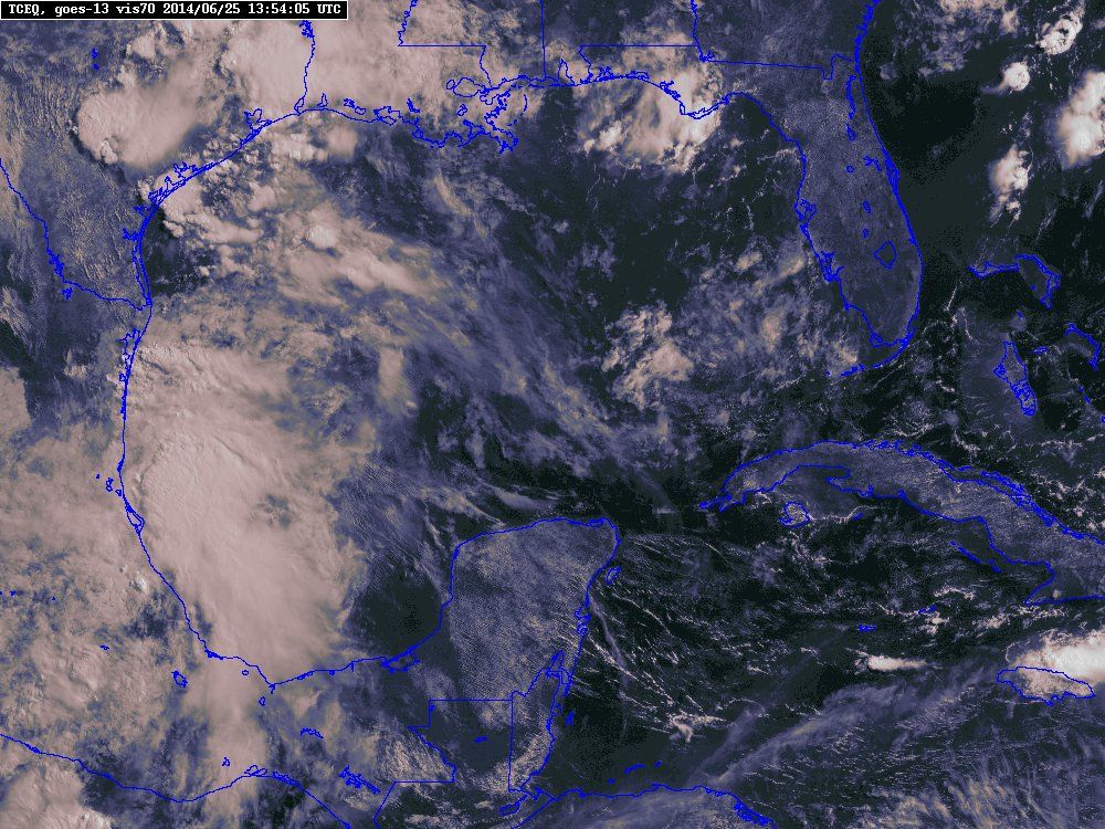
Radar lit up this morning throughout South Texas and check out that Western Gulf!
0 likes
Any forecasts under my name are to be taken with a grain of salt. Get your best forecasts from the National Weather Service and National Hurricane Center.
-
weatherdude1108
- Category 5
- Posts: 4228
- Joined: Tue Dec 13, 2011 1:04 pm
- Location: Northwest Austin/Cedar Park, TX


-
srainhoutx
- S2K Supporter
- Posts: 6919
- Age: 68
- Joined: Sun Jan 14, 2007 11:34 am
- Location: Haywood County, NC
- Contact:
Re: Re:
Portastorm wrote:Ntxw wrote:Just incredible the influx of moisture into Texas. Get under any shower and it pours. It's nice being inbetween ridges for a summer instead of having one over you.
Just drove through one of "those" showers in the PWC chasemobile, Champ the Charger, on my way to work. Champ loved the bath as the intensity of the rain honestly mirrored what he gets in his favorite car wash. It was one of those I-can't-see-20-feet-ahead-of-me rainstorms.
Radar lit up this morning throughout South Texas and check out that Western Gulf!
Steadily drifting N along the trough axis. Looks like a very wet 48 to possibly 72 hours at least. Next week may offer an inverted trough marching W across the Gulf from Florida putting us right back into a wet pattern.
0 likes
Carla/Alicia/Jerry(In The Eye)/Michelle/Charley/Ivan/Dennis/Katrina/Rita/Wilma/Ike/Harvey
Member: National Weather Association
Wx Infinity Forums
http://wxinfinity.com/index.php
Facebook.com/WeatherInfinity
Twitter @WeatherInfinity
Member: National Weather Association
Wx Infinity Forums
http://wxinfinity.com/index.php
Facebook.com/WeatherInfinity
Twitter @WeatherInfinity
-
Portastorm
- Storm2k Moderator
- Posts: 9955
- Age: 63
- Joined: Fri Jul 11, 2003 9:16 am
- Location: Round Rock, TX
- Contact:
Yeah, seeing dewpoints anywhere from upper 60s to mid 70s across much of the eastern two-thirds of the state is amazing! The moisture is plentiful.
0 likes
Any forecasts under my name are to be taken with a grain of salt. Get your best forecasts from the National Weather Service and National Hurricane Center.
-
South Texas Storms

- Professional-Met

- Posts: 4259
- Joined: Thu Jun 24, 2010 12:28 am
- Location: Houston, TX
Re: Texas Summer - 2014
Flash flooding is likely ongoing in the San Antonio, TX area this morning as heavy rain trains over the region. The San Antonio International Airport has already received nearly 3 inches of rain this morning! 
0 likes
-
gboudx

- S2K Supporter
- Posts: 4090
- Joined: Thu Sep 04, 2003 1:39 pm
- Location: Rockwall, Tx but from Harvey, La
Morning update from jeff. Mostly for you Central/South folks.
Excessive rainfall possible over the next 48 hours.
A lot of activity already ongoing this morning suggesting this tropical air mass needs little recovery time between rounds of heavy rainfall. Band of strong thunderstorms producing rainfall rates of .50 to .75 of an inch in 15-min is moving northward over central and eastern Harris County extending eastward along I-10 to Beaumont. Short fused street flooding is likely under this band of excessive rainfall.
Upstream air mass over the Gulf of Mexico is extremely moist with PWS ranging from 2.0-2.2 inches or very close to +2 SD above normal for late June on the Corpus Christi sounding. Such a tropical air mass will require little to no heating to produce rounds of heavy to excessive rainfall as clearly seen this morning. Suspect a short break over the next few hours after the passage of this line of weather followed by rapid redevelopment along the coast by late morning spreading inland once again this afternoon.
Short term models in a little better agreement that another break will occur this evening prior to the development of widespread and potentially significant rainfall on Thursday morning. Models are attempting to peg the area from Matagorda Bay to Houston to Liberty for deep convective development overnight and into Thursday morning as the central TX trough axis drifts eastward helping to focus lift over SE TX late tonight. Additionally, speed convergence near the coast/just inland will also result in lift as strong offshore winds weaken near the coast. Will have to keep a very close eye on short term guidance today to see if they continue this trend of a slow moving swath of heavy to excessive rainfall tonight which would likely lead to flooding.
Tropical air mass is firmly in place over the area with upstream satellite derived PWS over the southern Gulf pushing 2.4 inches, so the supply of moisture moving northward into the area will continue and with the weakness in the upper ridge over the area see no reason why it is not going to rain. Using PWS forecasting technique for slow moving or stalled convection suggest rainfall amounts could be on the order of several inches in a few hours. Thus far storms have shown good gust potential keeping them moving along their forward outflow boundaries, but any slowing of storm motions or cell training is going to get local areas into problems quickly. This air mass is very much capable of 2-4 inches of rainfall in an hour under heavy convection. HPC guidance is finally starting to look more realistic to the situation and shows widespread areal rainfall amounts of 1.0-3.0 inches through Friday and this still may be on the lower side especially if any sustained banding or training establishes itself. Could see isolated totals upwards of 8 inches or greater on top of what has already fallen. Yesterday alone nearly 4.0 inches fell on the NW side of Matagorda Bay and 2.0-3.0 inches over SE Harris County.
1-hr flash flood guidance is on the order of 2.0-3.0 inches over much of the region with 6-hr guidance in the 4.0-5.0 inch range. This air mass will be capable of exceeding these values over the next 48 hours generating significant run-off and rises on area stream, creeks, bayous, and rivers. Urban flooding is also likely given the high rainfall rates which will easily overwhelm local drainage systems.
0 likes
Re: Texas Summer - 2014
Very heavy rain falling here near the coast, probably around 4"/hr at this point. The street flooded in less than 20 minutes.
0 likes
-
srainhoutx
- S2K Supporter
- Posts: 6919
- Age: 68
- Joined: Sun Jan 14, 2007 11:34 am
- Location: Haywood County, NC
- Contact:
Re: Texas Summer - 2014
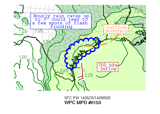
MESOSCALE PRECIPITATION DISCUSSION 0153
NWS WEATHER PREDICTION CENTER COLLEGE PARK MD
1204 PM EDT WED JUN 25 2014
AREAS AFFECTED...MIDDLE TX COAST
CONCERNING...HEAVY RAINFALL...FLASH FLOODING POSSIBLE
VALID 251603Z - 252203Z
SUMMARY...A GROWING MASS OF CONVECTION IS BUILDING WHILE SLOWLY
MOVING ASHORE THE MIDDLE TX COAST. DESPITE THE HIGH FLASH FLOOD
GUIDANCE VALUES, A FEW SPOTS OF FLASH FLOODING ARE POSSIBLE IN
THIS AREA.
DISCUSSION...AN OUTFLOW BOUNDARY FROM MORNING CONVECTION IS MOVING
DOWN THE TX COAST AT THE PRESENT TIME. NEAR AND AHEAD OF IT, A
COUPLE THUNDERSTORM COMPLEXES WITH COOLING TOPS ARE DEVELOPING
OVER THE NORTHWEST GULF OF MEXICO, WITH THUNDERSTORMS STARTING TO
ROLL INLAND. THE 0-6 KM SHEAR IS NEAR 25 KTS PER THE 14Z RAP,
INDICATING THAT ORGANIZED CONVECTION IS POSSIBLE IN THIS REGION.
PRECIPITABLE WATER VALUES OF 2-2.25" ARE MOVING INTO THE REGION,
WHICH ARE ABOVE THE 90TH PERCENTILE FOR LATE JUNE. CAPES OF
2000-3000 J/KG ARE DRIVING THE ACTIVITY. THE WET BULB ZERO HEIGHT
IN THE 12Z CORPUS CHRISTI AND LAKE CHARLES SOUNDINGS WAS ~14,500
FEET -- HIGH ENOUGH THAT WARM RAIN PROCESSES COULD BE AT PLAY
WHICH COULD LEAD TO RAINFALL AMOUNTS EXCEEDING RADAR ESTIMATES.
THE EXPECTATION IS THAT THE OUTFLOW BOUNDARY FROM SOUTHEAST TX
WILL DRIFT SOMEWHAT FURTHER DOWN THE COAST, AND THAT THE ACTIVITY
FROM THE GULF OF MEXICO MOVING INLAND WILL SET UP A COASTAL
CONVERGENCE ZONE DUE TO THE RAIN-COOLED AIR SETTING UP INLAND AND
THE CAPES BECOMING EXHAUSTED ASHORE. CORFIDI VECTORS ALMOST
DIRECTLY OPPOSE CELL MOTION AND THE WEAK LOW-LEVEL INFLOW, WHICH
COULD LEAD TO SLOW THUNDERSTORM MOVEMENT. RAINFALL RATES UP TO 3"
AN HOUR ARE POSSIBLE HERE IN STRONGER/MORE EFFICIENT STORMS.
SEVERAL PIECES OF MESOSCALE GUIDANCE -- THE LAST COUPLE HRRR RUNS,
THE 06Z CANADIAN REGIONAL, THE 12Z PARALLEL NAM CONEST, AND A
SIGNAL WITHIN THE 00Z SPC WRF INDICATE THAT LOCAL AMOUNTS OF 6-8"
ARE POSSIBLE HERE. DESPITE THE HIGH FLASH FLOOD GUIDANCE VALUES,
A FEW SPOTS COULD RECEIVE FLASH FLOODING WITHIN THE DEFINED AREA.
ROTH
ATTN...WFO...HGX...CRP...EWX...BRO...
ATTN...RFC...WGRFC...
0 likes
Carla/Alicia/Jerry(In The Eye)/Michelle/Charley/Ivan/Dennis/Katrina/Rita/Wilma/Ike/Harvey
Member: National Weather Association
Wx Infinity Forums
http://wxinfinity.com/index.php
Facebook.com/WeatherInfinity
Twitter @WeatherInfinity
Member: National Weather Association
Wx Infinity Forums
http://wxinfinity.com/index.php
Facebook.com/WeatherInfinity
Twitter @WeatherInfinity

-
Houstonia

- S2K Supporter
- Posts: 829
- Age: 61
- Joined: Fri Oct 11, 2002 9:45 am
- Location: Sharpstown, Houston, Harris County, Southeast Texas.
Re: Texas Summer - 2014
Here in downtown Houston at least, we aren't getting nearly as much rain as yesterday. No big downpours, no dark as night sky. Is anyone else in the Houston area getting rain?
0 likes
-
srainhoutx
- S2K Supporter
- Posts: 6919
- Age: 68
- Joined: Sun Jan 14, 2007 11:34 am
- Location: Haywood County, NC
- Contact:
Re: Texas Summer - 2014
Houstonia wrote:Here in downtown Houston at least, we aren't getting nearly as much rain as yesterday. No big downpours, no dark as night sky. Is anyone else in the Houston area getting rain?
The atmosphere stabilized after the early morning storms across most of Metro Houston. The cloud debris has kept the convective temperatures in check. The general thinking is additional storms will develop overnight as a stronger surge of moisture from the Western Gulf arrives. Areas that have seen breaks in the clouds like near Bryan/College Station are reporting extensive street flooding. The shorter term guidance is suggesting some areas from the Middle Texas Coast into the Houston area could see an additional 4-6 inches of rain tonight into tomorrow with some isolated locations possibly picking up 6 to 10 inches of heavy rainfall above what has already fallen.
0 likes
Carla/Alicia/Jerry(In The Eye)/Michelle/Charley/Ivan/Dennis/Katrina/Rita/Wilma/Ike/Harvey
Member: National Weather Association
Wx Infinity Forums
http://wxinfinity.com/index.php
Facebook.com/WeatherInfinity
Twitter @WeatherInfinity
Member: National Weather Association
Wx Infinity Forums
http://wxinfinity.com/index.php
Facebook.com/WeatherInfinity
Twitter @WeatherInfinity
-
SeGaBob
Re:
DonWrk wrote:Pretty amazing how any storms that get close to my area suddenly weaken and drop away 20-30 miles before they get here.
That happens here too. We had a line of storms coming towards us weaken unexpectedly on Monday and then reform on the other side of us. It stalled out after passing our area and put down 8-10 inches in some spots 1 or 2 counties to the south and east.(I only got a light shower out of it.) Depressing for sure as we've been in a dry spell lately.
I am glad some people in Texas are getting some good rains though.
0 likes
Re: Re:
SeGaBob wrote:DonWrk wrote:Pretty amazing how any storms that get close to my area suddenly weaken and drop away 20-30 miles before they get here.
That happens here too. We had a line of storms coming towards us weaken unexpectedly on Monday and then reform on the other side of us. It stalled out after passing our area and put down 8-10 inches in some spots 1 or 2 counties to the south and east.(I only got a light shower out of it.) Depressing for sure as we've been in a dry spell lately.
I am glad some people in Texas are getting some good rains though.
Ouch! I know it happens everywhere but man, it's been pretty bad here lately! I won't even go into details.
0 likes
-
TheProfessor

- Professional-Met
- Posts: 3506
- Age: 29
- Joined: Tue Dec 03, 2013 10:56 am
- Location: Wichita, Kansas
-
Portastorm
- Storm2k Moderator
- Posts: 9955
- Age: 63
- Joined: Fri Jul 11, 2003 9:16 am
- Location: Round Rock, TX
- Contact:
Re: Texas Summer - 2014
If you read this AFD and then go back and read the one issued early this morning, you'll see how EWX's initial thoughts of the trough/shear axis over much of central/eastern Texas have changed. Some of the models for days have tried to diminish or move this thing and it just isn't happening. More welcomed rains coming for many of us, I believe.
AREA FORECAST DISCUSSION
NATIONAL WEATHER SERVICE AUSTIN/SAN ANTONIO TX
330 PM CDT WED JUN 25 2014
.SHORT TERM (TONIGHT THROUGH THURSDAY NIGHT)...
ISOLATED TO SCATTERED SHOWERS AND THUNDERSTORMS CONTINUED ACROSS
SOUTH CENTRAL TEXAS DUE TO A MOIST AIRMASS (PWS 1.7 TO 2 INCHES)
WITH INSTABILITY DEVELOPING DUE TO SOLAR HEATING UNDERNEATH AN
UPPER LEVEL TROUGH CENTERED OVER CENTRAL TEXAS. SHOWERS AND
THUNDERSTORMS WILL DECREASE THIS EVENING AS THE AIRMASS STABILIZES
SOMEWHAT WITH SUNSET. THE TROUGH WILL NOT MOVE MUCH OVERNIGHT INTO
THURSDAY AND MAY EVEN GET REENERGIZED BY AN UPPER LEVEL SHORT-WAVE
MOVING INTO WEST TEXAS THIS AFTERNOON. THE MOIST AIRMASS REMAINS
NEAR AND TO THE EAST OF THE TROUGH. EXPECT SHOWERS AND
THUNDERSTORMS TO REDEVELOP TOWARD MORNING SIMILAR TO EARLIER TODAY
AND ALONG AN ENHANCED SEABREEZE DURING THE AFTERNOON. THERE COULD
BE SOME LOCALLY HEAVY RAINFALL THAT MAY CAUSE SOME FLOODING
PROBLEMS. THE SHOWERS AND THUNDERSTORMS DECREASE THURSDAY EVENING
AS THE AIRMASS AGAIN STABILIZES.
&&
.LONG TERM (FRIDAY THROUGH WEDNESDAY)...
MODELS CONTINUE THEIR TRENDS TO WEAKEN THE TROUGH INTO A SHEAR
AXIS WHILE STRENGTHENING THE SUBTROPICAL RIDGE OVER THE
SOUTHWESTERN STATES. THE AIRMASS ALOFT SLOWLY DRIES WITH WARMING
MID LEVEL TEMPERATURES OVER THE NEXT FEW DAYS. SHOWERS AND
THUNDERSTORMS ARE EXPECTED ACROSS THE EASTERN HALF OF SOUTH
CENTRAL TEXAS FRIDAY INTO THIS WEEKEND DURING THE DAYTIME INTO
EVENING HOURS AS WEAK TROUGHING AND INSTABILITY REMAINS. SHOWERS
AND THUNDERSTORMS WILL BECOME MAINLY FORCED BY THE SEABREEZE AND
CONFINED TO AREAS NEAR THE COASTAL PLAINS NEXT WEEK AS THE RIDGE
BUILDS EAST INTO TEXAS
0 likes
Any forecasts under my name are to be taken with a grain of salt. Get your best forecasts from the National Weather Service and National Hurricane Center.
-
South Texas Storms
- Professional-Met
- Posts: 4259
- Joined: Thu Jun 24, 2010 12:28 am
- Location: Houston, TX
Re: Texas Summer - 2014
What a wet morning it was across much of San Antonio! The San Antonio International Airport has received 2.98 inches of rain so far today. This makes today the 12th wettest June day on record! More rain chances are in the forecast through Friday with locally heavy rainfall possible across the eastern half of Texas.

Uploaded with ImageShack.us
0 likes
Return to “USA & Caribbean Weather”
Who is online
Users browsing this forum: No registered users and 193 guests