Texas Spring-2015
Moderator: S2k Moderators
Forum rules
The posts in this forum are NOT official forecast and should not be used as such. They are just the opinion of the poster and may or may not be backed by sound meteorological data. They are NOT endorsed by any professional institution or STORM2K.
-
weatherdude1108
- Category 5

- Posts: 4228
- Joined: Tue Dec 13, 2011 1:04 pm
- Location: Northwest Austin/Cedar Park, TX
- Portastorm
- Storm2k Moderator

- Posts: 9955
- Age: 63
- Joined: Fri Jul 11, 2003 9:16 am
- Location: Round Rock, TX
- Contact:
Re:
weatherdude1108 wrote:About an inch from this morning's activity and still raining.
Got close to an inch and a half here at the Portastorm Weather Center in not-so-scenic (today) southwestern Travis County.
0 likes
Any forecasts under my name are to be taken with a grain of salt. Get your best forecasts from the National Weather Service and National Hurricane Center.
-
aggiecutter
- Category 5

- Posts: 1755
- Joined: Thu Oct 14, 2004 9:22 pm
- Location: Texarkana
- wxman57
- Moderator-Pro Met

- Posts: 23175
- Age: 68
- Joined: Sat Jun 21, 2003 8:06 pm
- Location: Houston, TX (southwest)
Re: Texas Spring-2015
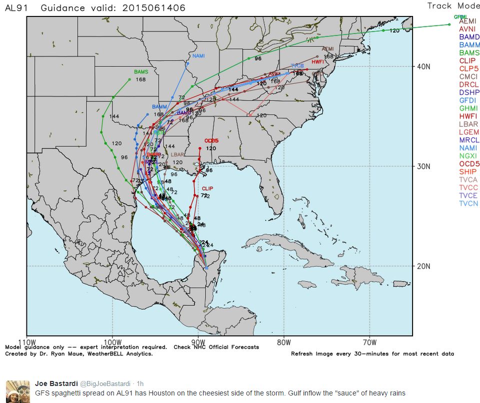
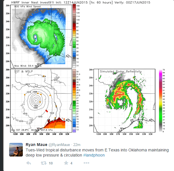
I think that the models are initializing the center too far south, maybe by 150 miles. That would shift the heavier rain threat east a bit to between Houston and the mid LA coast, possibly.
0 likes
- TeamPlayersBlue
- Category 5

- Posts: 3531
- Joined: Tue Feb 02, 2010 1:44 am
- Location: Denver/Applewood, CO
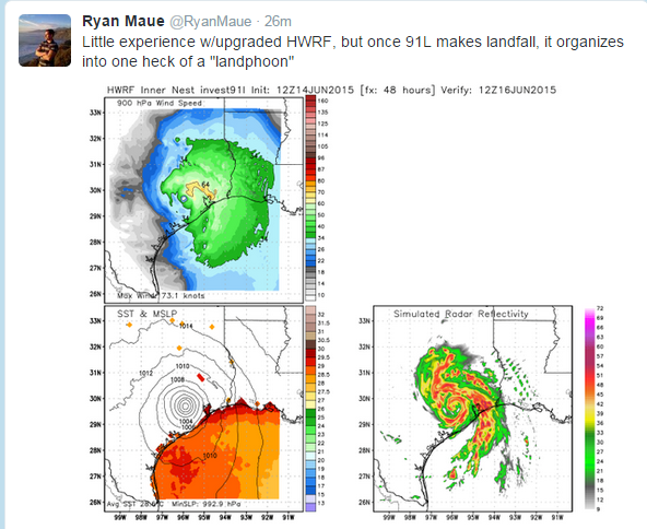
Havent had to use the links in forever but what do the steering currents look like? The HWRF is showing a 992 max wind at 52 winds while its still a tad off the coast but the next plot is onshore.
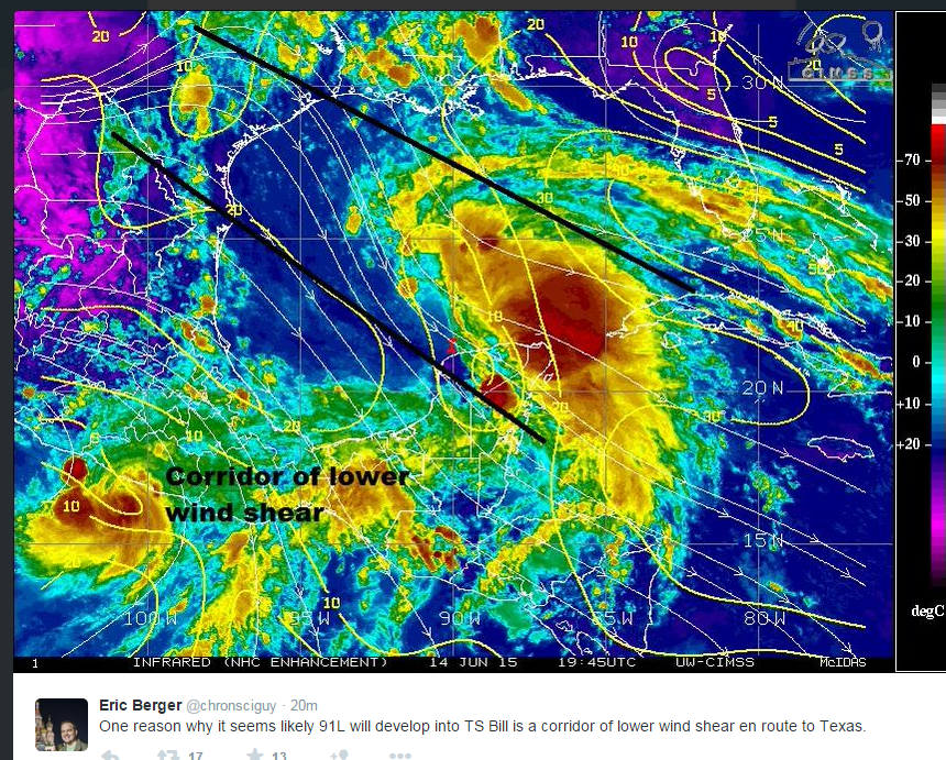
Havent looked at the shear yet but we have seen these storms spin up very very quickly. Must keep an eye on it.
Havent looked at the shear yet but we have seen these storms spin up very very quickly. Must keep an eye on it.
0 likes
Personal Forecast Disclaimer:
The posts in this forum are NOT official forecast and should not be used as such. They are just the opinion of the poster and may or may not be backed by sound meteorological data. They are NOT endorsed by any professional institution or storm2k.org. For official information, please refer to the NHC and NWS products.
The posts in this forum are NOT official forecast and should not be used as such. They are just the opinion of the poster and may or may not be backed by sound meteorological data. They are NOT endorsed by any professional institution or storm2k.org. For official information, please refer to the NHC and NWS products.
-
aggiecutter
- Category 5

- Posts: 1755
- Joined: Thu Oct 14, 2004 9:22 pm
- Location: Texarkana
-
aggiecutter
- Category 5

- Posts: 1755
- Joined: Thu Oct 14, 2004 9:22 pm
- Location: Texarkana
Re: Re:
Portastorm wrote:weatherdude1108 wrote:About an inch from this morning's activity and still raining.
Got close to an inch and a half here at the Portastorm Weather Center in not-so-scenic (today) southwestern Travis County.
I recorded 2.21 inches with this mornings rain at my house. It really came down hard. The elongated storm moved right overhead through south central and central Travis County.
0 likes
Resident Rain Miser
I am a weather hobbyist living 3.5 miles south of Downtown Austin and in no way or fashion should anything I say concerning forecasts be taken seriously. Please check your local NWS for accurate weather forecasting and conditions.
I am a weather hobbyist living 3.5 miles south of Downtown Austin and in no way or fashion should anything I say concerning forecasts be taken seriously. Please check your local NWS for accurate weather forecasting and conditions.
- TheProfessor
- Professional-Met

- Posts: 3506
- Age: 29
- Joined: Tue Dec 03, 2013 10:56 am
- Location: Wichita, Kansas
0 likes
The above post and any post by Ntxw is NOT an official forecast and should not be used as such. It is just the opinion of the poster and may or may not be backed by sound meteorological data. It is NOT endorsed by any professional institution including Storm2k. For official information, please refer to NWS products.
-
weatherdude1108
- Category 5

- Posts: 4228
- Joined: Tue Dec 13, 2011 1:04 pm
- Location: Northwest Austin/Cedar Park, TX
Re: Re:
JDawg512 wrote:Portastorm wrote:weatherdude1108 wrote:About an inch from this morning's activity and still raining.
Got close to an inch and a half here at the Portastorm Weather Center in not-so-scenic (today) southwestern Travis County.
I recorded 2.21 inches with this mornings rain at my house. It really came down hard. The elongated storm moved right overhead through south central and central Travis County.
We got a couple heavy tropical downpours around the 4pm hour this afternoon. Another 1.2 inches. With this morning's rain, I am at 2.4 inches today.
0 likes
- 1900hurricane
- Category 5

- Posts: 6063
- Age: 34
- Joined: Fri Feb 06, 2015 12:04 pm
- Location: Houston, TX
- Contact:
I'd really be paying attention if I lived in the eastern half of the EWX area. After the several inches of rain many areas saw today, the slight westward edging of 91L's model consensus is somewhat concerning.
0 likes
Contract Meteorologist. TAMU & MSST. Fiercely authentic, one of a kind. We are all given free will, so choose a life meant to be lived. We are the Masters of our own Stories.
Opinions expressed are mine alone.
Follow me on Twitter at @1900hurricane : Read blogs at https://1900hurricane.wordpress.com/
Opinions expressed are mine alone.
Follow me on Twitter at @1900hurricane : Read blogs at https://1900hurricane.wordpress.com/
Re:
1900hurricane wrote:I'd really be paying attention if I lived in the eastern half of the EWX area. After the several inches of rain many areas saw today, the slight westward edging of 91L's model consensus is somewhat concerning.
Everyone in the eastern half of the state needs to. As many have had historic May rainfalls, June is going to follow it up with some big totals.
0 likes
The above post and any post by Ntxw is NOT an official forecast and should not be used as such. It is just the opinion of the poster and may or may not be backed by sound meteorological data. It is NOT endorsed by any professional institution including Storm2k. For official information, please refer to NWS products.
- TheProfessor
- Professional-Met

- Posts: 3506
- Age: 29
- Joined: Tue Dec 03, 2013 10:56 am
- Location: Wichita, Kansas
- Portastorm
- Storm2k Moderator

- Posts: 9955
- Age: 63
- Joined: Fri Jul 11, 2003 9:16 am
- Location: Round Rock, TX
- Contact:
Re: Re:
Ntxw wrote:1900hurricane wrote:I'd really be paying attention if I lived in the eastern half of the EWX area. After the several inches of rain many areas saw today, the slight westward edging of 91L's model consensus is somewhat concerning.
Everyone in the eastern half of the state needs to. As many have had historic May rainfalls, June is going to follow it up with some big totals.
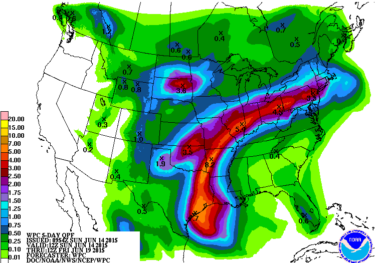
Pretty much anyone along or east of the I-35 corridor is now " in play" best on the west model trends overnight. Very serious if not catastrophic flooding appears likely by Wednesday.
0 likes
Any forecasts under my name are to be taken with a grain of salt. Get your best forecasts from the National Weather Service and National Hurricane Center.
-
weatherdude1108
- Category 5

- Posts: 4228
- Joined: Tue Dec 13, 2011 1:04 pm
- Location: Northwest Austin/Cedar Park, TX
Re: Re:
Portastorm wrote:Ntxw wrote:1900hurricane wrote:I'd really be paying attention if I lived in the eastern half of the EWX area. After the several inches of rain many areas saw today, the slight westward edging of 91L's model consensus is somewhat concerning.
Everyone in the eastern half of the state needs to. As many have had historic May rainfalls, June is going to follow it up with some big totals.
Pretty much anyone along or east of the I-35 corridor is now " in play" best on the west model trends overnight. Very serious if not catastrophic flooding appears likely by Wednesday.
Of course the threat is not over the Lake Buchanan watershed, which is 16 feet below average and about 25 feet below its conservation pool. It still has a flood "cushion." Travis has a flood cushion also, but not as much as early May.
http://hydromet.lcra.org/lakevolume/systemprofile.aspx
0 likes
The preceding post is NOT an official forecast, and should not be used as such. It is only the opinion of the poster and may or may not be backed by sound meteorological data. It is NOT endorsed by any professional institution including storm2k.org. For Official Information please refer to the NHC and NWS products.
It's interesting it's pressures continues to lower over land on some guidance. That HWRF Ryan Maue posted yesterday doesn't look so far-fetched today. Looking at the flow the area between I-35 and I-45 looks like the bullseye (at this time). I'd go ahead if I were the NWS and put flood watches up and down the region between the two.
0 likes
The above post and any post by Ntxw is NOT an official forecast and should not be used as such. It is just the opinion of the poster and may or may not be backed by sound meteorological data. It is NOT endorsed by any professional institution including Storm2k. For official information, please refer to NWS products.
- TheProfessor
- Professional-Met

- Posts: 3506
- Age: 29
- Joined: Tue Dec 03, 2013 10:56 am
- Location: Wichita, Kansas
- TeamPlayersBlue
- Category 5

- Posts: 3531
- Joined: Tue Feb 02, 2010 1:44 am
- Location: Denver/Applewood, CO
Just had our first tropical shower come through and oh my word, went from drizzle to straight DOWNPOUR in an instant.
Also, who else saw the projected PW at 4.2 inches. I have never seen a 3 inch PW. Thats insane. I think Maue posted it yesterday
Also, who else saw the projected PW at 4.2 inches. I have never seen a 3 inch PW. Thats insane. I think Maue posted it yesterday
0 likes
Personal Forecast Disclaimer:
The posts in this forum are NOT official forecast and should not be used as such. They are just the opinion of the poster and may or may not be backed by sound meteorological data. They are NOT endorsed by any professional institution or storm2k.org. For official information, please refer to the NHC and NWS products.
The posts in this forum are NOT official forecast and should not be used as such. They are just the opinion of the poster and may or may not be backed by sound meteorological data. They are NOT endorsed by any professional institution or storm2k.org. For official information, please refer to the NHC and NWS products.
-
weatherdude1108
- Category 5

- Posts: 4228
- Joined: Tue Dec 13, 2011 1:04 pm
- Location: Northwest Austin/Cedar Park, TX
This is a "stay tuned" kind of update.
000
FXUS64 KEWX 151614
AFDEWX
AREA FORECAST DISCUSSION
NATIONAL WEATHER SERVICE AUSTIN/SAN ANTONIO TX
1114 AM CDT MON JUN 15 2015
.UPDATE...BROAD AREA OF LOW PRESSURE ACROSS THE SOUTH-CENTRAL GULF
OF MEXICO CONTINUES TRACKING TO THE NORTHWEST. EASTERLY FLOW
ACROSS THE REGION WITH AMPLE MOISTURE IN PLACE...AND DE-STABILIZATION
THROUGH THE DAY WILL LEAD TO THE DEVELOPMENT OF SCATTERED SHOWERS
AND THUNDERSTORMS THROUGH THE DAY ACROSS CENTRAL AND EASTERN
ZONES. IN ADDITION...WHAT APPEARS TO BE A REMNANT MCV ACROSS WEST-
CENTRAL TEXAS MAY ENHANCE SHOWERS AND THUNDERSTORMS ACROSS THE
EDWARDS PLATEAU/NORTHERN HILL COUNTRY THIS AFTERNOON. CURRENT POP
FORECAST FOR TODAY WITH LOCALLY HEAVY RAINFALL MENTION ACROSS THE
EAST LOOK GOOD AND NO UPDATES PLANNED AT THIS TIME TO TODAYS
FORECAST. MORE COMING IN THE AFTERNOON PACKAGE ON THE HEAVY
RAINFALL POTENTIAL WITH THE TROPICAL SYSTEM.
0 likes
The preceding post is NOT an official forecast, and should not be used as such. It is only the opinion of the poster and may or may not be backed by sound meteorological data. It is NOT endorsed by any professional institution including storm2k.org. For Official Information please refer to the NHC and NWS products.
Return to “USA & Caribbean Weather”
Who is online
Users browsing this forum: Brent, txtwister78, wxman22 and 97 guests


